This is Our Planet From a Million Miles Away
Earth imaged on July 6, 2015 by NOAA's DSCOVR satellite from L1. Credit: NOAA/NASA/GSFC
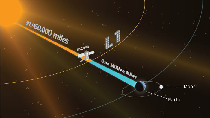
This picture of our home planet truly is EPIC – literally! The full-globe image was acquired with NASA’s Earth Polychromatic Imaging Camera (aka EPIC; see what they did there) on board NOAA’s DSCOVR spacecraft, positioned nearly a million miles (1.5 million km) away at L1.
L1 is one of five Lagrange points that exist in space where the gravitational pull between Earth and the Sun are sort of canceled out, allowing spacecraft to be “parked” there. (Learn more about Lagrange points here.) Launched aboard a SpaceX Falcon 9 on Feb. 11, 2015, the Deep Space Climate Observatory (DSCOVR) arrived at L1 on June 8 and, after a series of instrument checks, captured the image of Earth’s western hemisphere above on July 6.
The EPIC instrument has the capability to capture images in ten narrowband channels from infrared to ultraviolet; the true-color picture above was made from images acquired in red, green, and blue visible-light wavelengths.
More than just a pretty picture of our blue marble, this image will be used by the EPIC team to help calibrate the instrument to remove some of the blue atmospheric haze from subsequent images. Once the camera is fully set to begin operations daily images of our planet will be made available on a dedicated web site starting in September.
Designed to provide early warnings of potentially-disruptive geomagnetic storms resulting from solar outbursts, DSCOVR also carries Earth-observing instruments that will monitor ozone and aerosols in the atmosphere and measure the amount of energy received, reflected, and emitted by Earth – the planet’s “energy budget.”
But also, from its permanent location a million miles away, DSCOVR will be able to get some truly beautiful – er, EPIC – images of our world.
DSCOVR is a joint mission between NOAA, NASA, and the U.S. Air Force. Learn more about DSCOVR here.
Source: NASA
UPDATE: President Obama liked this image so much, he decided to Tweet about it with a message of planetary conservation!
UPDATE 7/29/15: Here’s another view from DSCOVR on July 6, showing Europe, Africa, and the Middle East:
Recent Posts
Black Holes Can Halt Star Formation in Massive Galaxies
It’s difficult to actually visualise a universe that is changing. Things tend to happen at…
Mapping the Milky Way’s Magnetic Field in 3D
We are all very familiar with the concept of the Earth’s magnetic field. It turns…

NASA’s New Solar Sail Has Launched and Deployed
Solar Sails are an enigmatic and majestic way to travel across the gulf of space.…
Here’s Why We Should Put a Gravitational Wave Observatory on the Moon
Scientists detected the first long-predicted gravitational wave in 2015, and since then, researchers have been…
TESS Finds its First Rogue Planet
Well over 5,000 planets have been found orbiting other star systems. One of the satellites…
There are Four Ways to Build with Regolith on the Moon
Over the last few years I have been renovating my home. Building on Earth seems…