
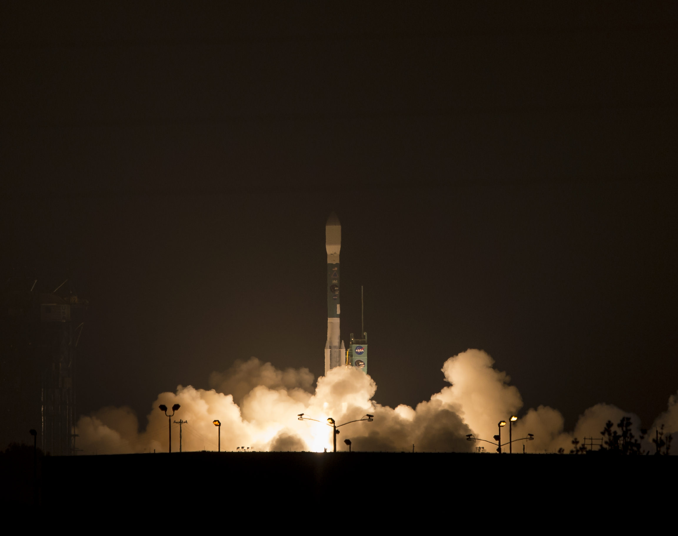
NASA’s Soil Moisture Active Passive (SMAP) observatory, on a United Launch Alliance Delta II rocket, is seen after the mobile service tower was rolled back Friday, Jan. 30 at Space Launch Complex 2, Vandenberg Air Force Base, Calif.
Image Credit: NASA/Bill Ingalls
Story updated[/caption]
At dawn this morning (Jan. 31) NASA launched an advanced Earth science satellite aimed at making measurements of our planet’s surface soil moisture and freeze/thaw states from space that will revolutionize our understanding of the water, energy, and carbon cycles driving all life on Earth, aid weather forecasting and improve climate change models.
NASA’s new Soil Moisture Active Passive (SMAP) observatory thundered off the pad at 6:22 a.m. PST (9:22 a.m. EST) Saturday atop a two stage United Launch Alliance Delta II rocket from Space Launch Complex 2 on Vandenberg Air Force Base, California.
The $916 million satellite successfully separated from the rocket’s second stage some 57 minutes after the flawless liftoff and was injected into an initial 411- by 425-mile (661- by 685-kilometer) orbit. The spacecraft then deployed its solar arrays and telemetry indicated it was in excellent health.
“We’re in contact with SMAP and everything looks good right now,” NASA Launch Manager Tim Dunn said.
“Deployment of the solar arrays is underway. We just couldn’t be happier.”
SMAP separated from the second stage while pointed toward the sun as seen in the video below from a rocket mounted camera:
Video Caption: A camera on the second stage of the Delta II rocket captured this footage as the SMAP spacecraft pushed itself away from the rocket to complete the delivery of the Earth-observing spacecraft to its proper orbit following Jan. 31, 2015 liftoff. Credit: NASA TV/ULA
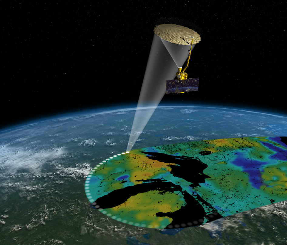
SMAP is NASA’s 1st Earth observing satellite designed to make high resolution global observations of Earth’s vital surface soil moisture content and freeze/thaw cycle just below your feet. It will aid global forecasting and have broad applications for science and society.
SMAP’s combined radar and radiometer instruments will peer into the top 2 inches (5 centimeters) of soil, through clouds and moderate vegetation cover, day and night, to produce the highest-resolution, most accurate soil moisture maps ever obtained from space, says NASA.
The blastoff of SMAP successfully concluded NASA’s ambitious plans to launch a record breaking total of five Earth science satellites in less than a year’s time.
“The launch of SMAP completes an ambitious 11-month period for NASA that has seen the launch of five new Earth-observing space missions to help us better understand our changing planet,” said NASA Administrator Charles Bolden.
“Scientists and policymakers will use SMAP data to track water movement around our planet and make more informed decisions in critical areas like agriculture and water resources.”
SMAP is projected to last for at least a three year primary mission.
The prior NASA Earth science instrument launched was the Cloud Aerosol Transport System (CATS) payload hauled to space by the SpaceX CRS-4 Dragon on Jan. 10, 2015 and recently installed on the exterior of the ISS. Read my CATS installation story – here.
The three earlier NASA Earth science missions launched over the past year included ISS-RapidScat in September 2014, the Global Precipitation Measurement (GPM) Core Observatory, a joint mission with the Japan Aerospace Exploration Agency, in February 2014, and the Orbiting Carbon Observatory-2 (OCO-2) carbon observatory in July 2014.
“Congratulations to the NASA Launch Services Program team, JPL and all of our mission partners on today’s successful launch of the SMAP satellite,” said Jim Sponnick, ULA vice president, Atlas and Delta Programs.
“It is our honor to launch this important Earth science mission to help scientists observe and predict natural hazards, and improve our understanding of Earth’s water, energy and carbon cycles.”
SMAP will provide high-resolution, space-based measurements of soil moisture and its state — frozen or thawed — a new capability that will allow scientists to better predict natural hazards of extreme weather, climate change, floods and droughts, and help reduce uncertainties in our understanding of Earth’s water, energy and carbon cycles, according to a NASA description.
The mission will map the entire globe every two to three days for at least three years and provide the most accurate and highest-resolution maps of soil moisture ever obtained. The spacecraft’s final circular polar orbit will be 426 miles (685 kilometers), at an inclination of 98.1 degrees. The spacecraft will orbit Earth once every 98.5 minutes and repeat the same ground track every eight days.
“All subsystems are being powered on and checked out as planned,” Kent Kellogg, the SMAP project manager, during a post-launch press conference.
“Communications, guidance and control, computers and power are all operating nominally.”
The observatory is in excellent health. Its instruments will be turned on in 11 days.
Today’s blastoff of SMAP marks ULA’s second successful launch this month as well as the second of 13 planned for 2015. ULA’s first launch of 2015 was MUOS-3 from Cape Canaveral on Jan. 20.
ULA’s next launch involves NASA’s Magnetospheric Multiscale Mission (MMS) to study Earth’s magnetic reconnection. It is scheduled for launch on an Atlas V 421 booster on March 12 from Cape Canaveral. See my up close visit with MMS and NASA Administrator Charles Bolden at NASA Goddard Space Flight Center detailed in my story – here.
Stay tuned here for Ken’s continuing Earth and planetary science and human spaceflight news.
I got up early to watch this launch. MAN-O-MANN, that Delta II just leaped into the sky! Of course, the low cloud deck didn’t help matters. The rocket was in the marine layer and out of sight almost instantly.
I’d read somewhere that this launch MIGHT be visible from the S.F. Bay Area, so I looked for it, only to be disappointed. MAYBE it was visible down in the SOUTH Bay.. but not up here in the NORTH Bay. Drat…