Danny – First Atlantic Hurricane of 2015 as Seen from Space Station by Scott Kelly

NASA Astronaut Scott Kelly took this picture of Hurricane Danny on August 20 at 6 a.m. EDT from aboard the International Space Station. Credits: NASA

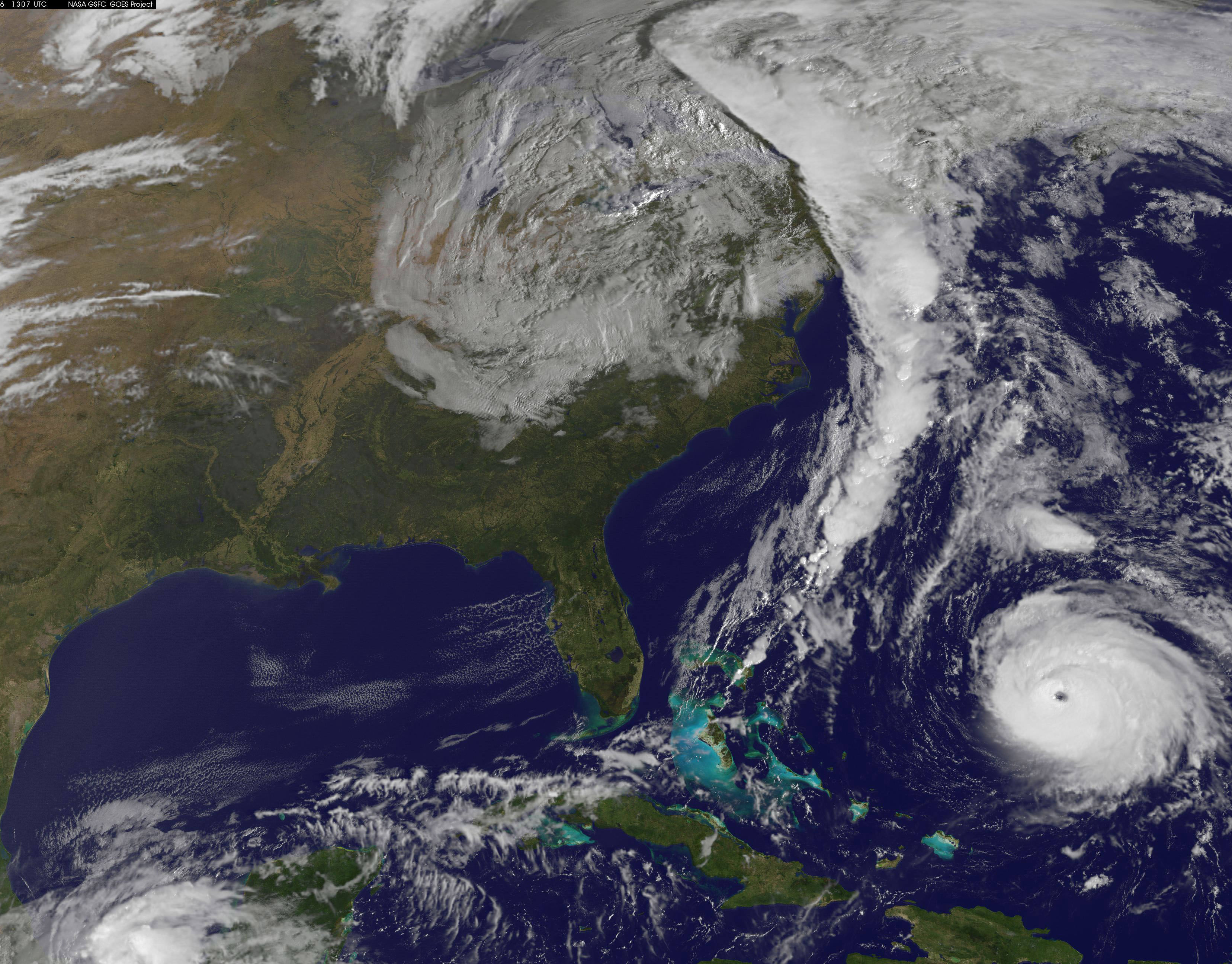
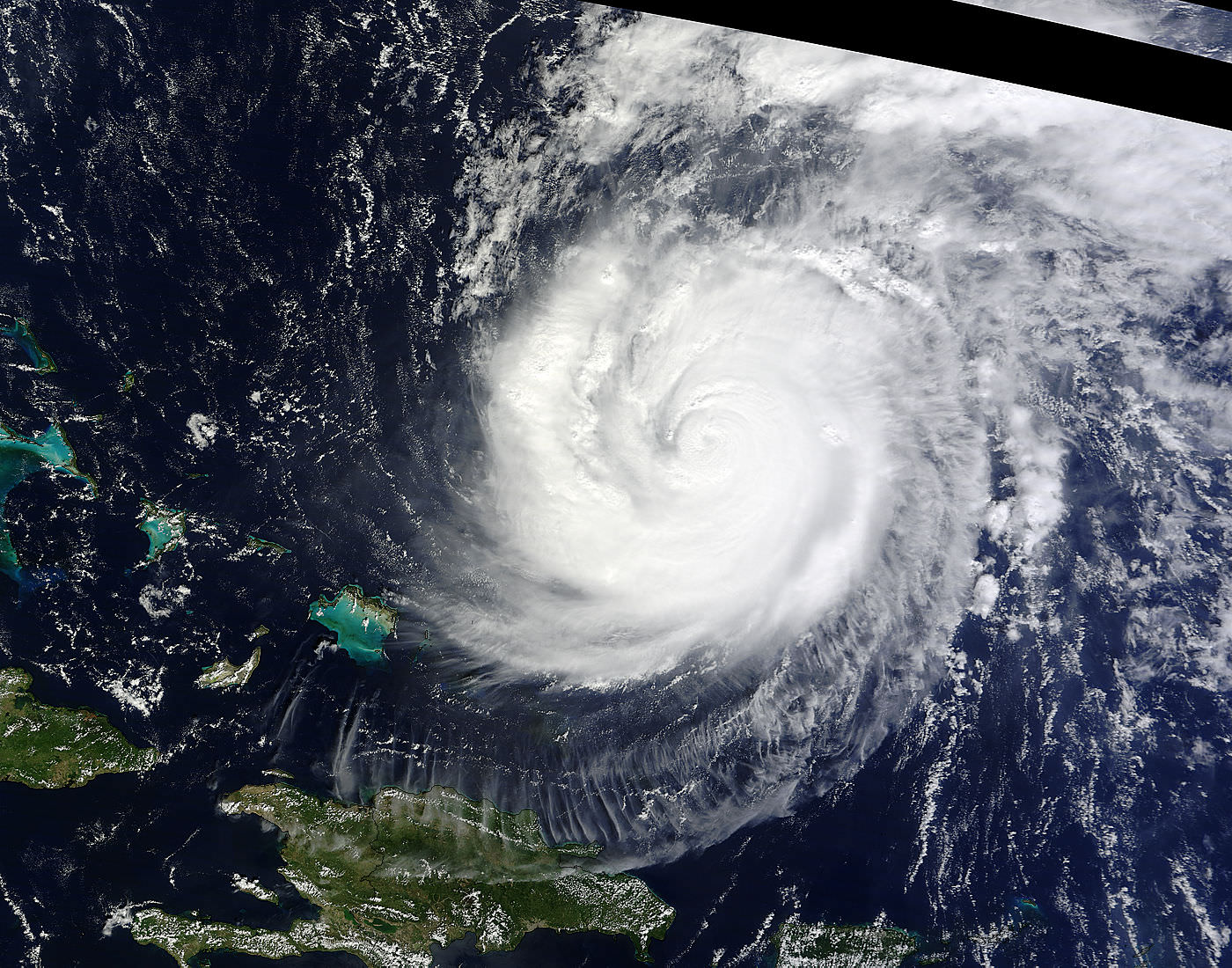
Hurricane Danny, the first Atlantic Ocean hurricane of the 2015 season has been caught on camera by NASA astronaut Scott Kelly, in a beautiful image taken on Thursday, August 20 at 6 a.m. EDT from his glorious perch aboard the International Space Station (ISS).

Poking majestically down at the sprawling hurricane is the space stations Canadian-built robotic arm that will be used by Kelly in a few days to grapple Kounotori, the Japanese cargo ship launched earlier this week and berth it at a docking port.

Kelly is nearly five months into his year-long stay aboard the ISS and is a prolific photographer of the natural wonders of our home planet.

“Hurricane Danny. Keeping an eye on you from the International Space Station. Looks like you’re 1st in the Atlantic this year. Stay safe below! #YearInSpace,” wrote Kelly on his Facebook and twitter pages.

Danny had risen to a Category 3 hurricane by Friday afternoon, August 21, with winds over 115 mph and was moving westward in the Central Atlantic Ocean towards the Leeward Islands in the Caribbean.

By 11 a.m. EDT (1500 UTC) on Friday, August 21, the eye of Hurricane Danny was located near latitude 14.0 North, longitude 48.2 West, according to NASA. The center of Danny was about 930 miles (1,195 km) east of the Leeward Islands. With maximum sustained winds of near 105 mph (165 kph), Danny was a Category 2 hurricane on the Saffir-Simpson Hurricane Wind Scale.

By 8:00 p.m. Friday evening, Friday, the National Hurricane Center said Danny was located over the central tropical Atlantic Ocean about 800 miles east of the Leeward Islands.

Late this evening at 11 p.m., the National Hurricane Center said it had weakened slightly back to a Category 2 storm with maximum winds of 110 mph and was located at 14.8°N and 49.8°W while moving west northwest at 10 mph.

The NASA GOES-East animation below combines visible and infrared imagery showing Hurricane Danny’s movement in the eastern and central Atlantic Ocean from Aug. 18 to 21, 2015.

Video caption: Hurricane Danny Seen By GOES-East. This animation of visible and infrared imagery of Hurricane Danny in the Central Atlantic Ocean was taken from NOAA’s GOES-East satellite from Aug. 18 to 21. Credits: NASA/NOAA GOES Project

Forecasters with the National Hurricane Center think it may weaken over the next few days as it heads towards the Caribbean islands.

“Vertical shear is expected to increase further during the next couple of days, which should allow drier air in the surrounding environment to penetrate into Danny’s circulation. Therefore,there is no change in the thinking that Danny should weaken as it approaches and moves across the Leeward Islands and the Greater Antilles during the forecast period.”

Danny could reach Puerto Rico by Monday in a weakened state.

Although it’s still far away from the US, it’s not expected to impact the East Coast but that could change.

If Danny were to take aim at the US, it could impact plans to launch the Air Force MUOS-4 satellite on Aug. 31 from Cape Canaveral Air Force Station by United Launch Alliance (ULA).

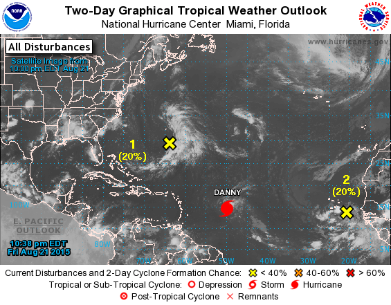
Here’s a map showing the current location:

Hurricane Danny location on Aug. 21, 2015. Credit: National Hurricane Center

On Aug. 19, NASA’s Global Precipitation Measurement (GPM) mission core satellite passed over Danny and analyzed the structure of its rainfall, as seen in this image.

On Aug. 19, 2015 GPM saw Danny's rain structure was still asymmetric as noted by the large rain band (identified by the green arc indicating moderate rain) being located mainly on the eastern side of the storm. Within this rain band, GPM detected rain rates of up to 73.9 mm/hour (shown in darker red).Credits: SSAI/NASA, Hal Pierce
On Aug. 19, 2015 GPM saw Danny’s rain structure was still asymmetric as noted by the large rain band (identified by the green arc indicating moderate rain) being located mainly on the eastern side of the storm. Within this rain band, GPM detected rain rates of up to 73.9 mm/hour (shown in darker red).Credits: SSAI/NASA, Hal Pierce

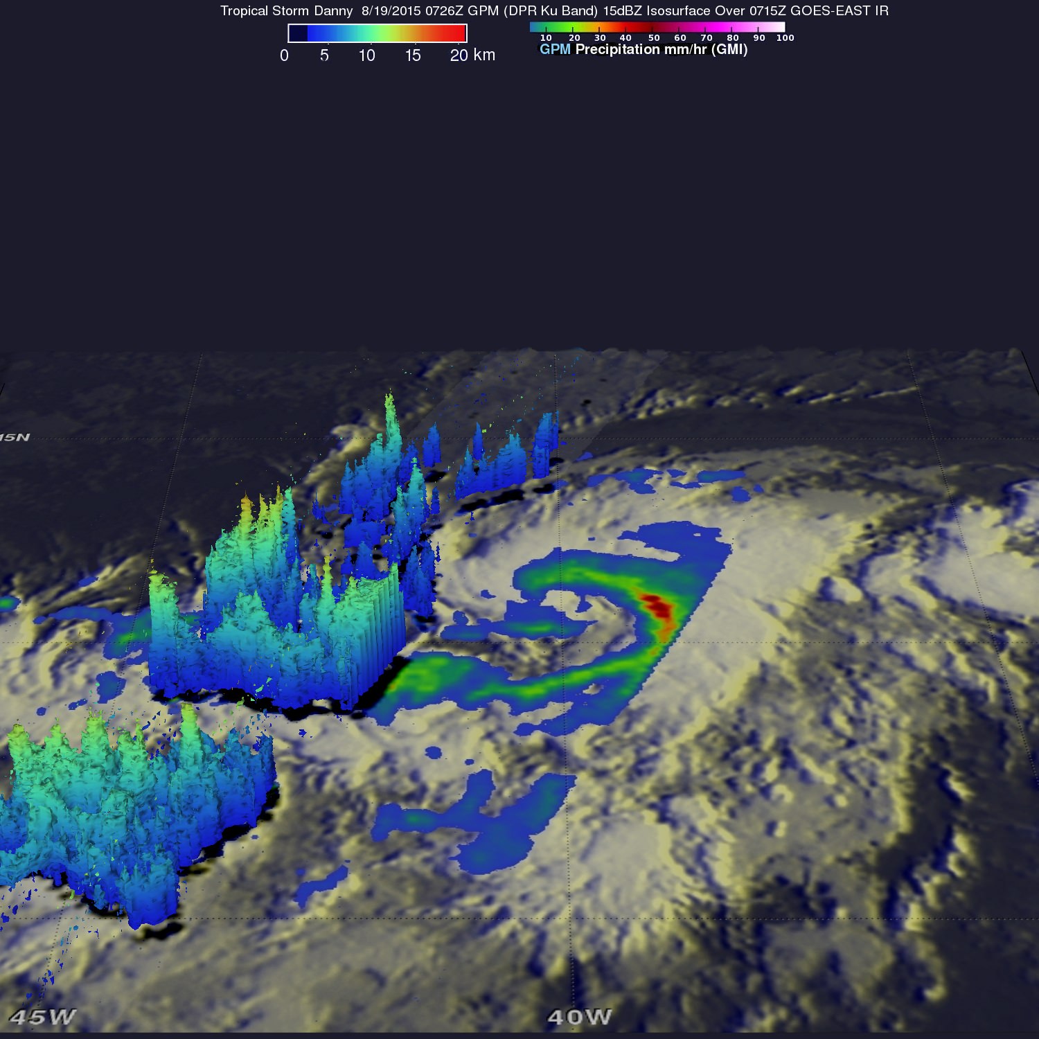
A research team at NASA’s Goddard Space Flight Center in Greenbelt, Maryland, created a 3-D rendering of Danny using data from the GPM DPR (Dual-frequency Precipitation Radar) instrument.

“GPM showed that Danny was still in the process of becoming organized. The rain structure was still very asymmetric as noted by a large rain band being located mainly on the eastern side of the storm. Within this rain band, GPM detected rain rates of up to 73.9 mm/hour. At the time of this image, Danny was still a minimal tropical storm with sustained winds estimated at 50 mph by the National Hurricane Center (NHC),” said officials.

And dont forget that you can watch Commander Scott Kelly and his five international crew mates on a regular basis as they soar overhead. Just click on NASA’s Spot the Station link and plug in your location.

ISS crosses the Big Dipper over NJ.  Credit: Ken Kremer/kenkremer.com
ISS crosses the Big Dipper over NJ. Credit: Ken Kremer/kenkremer.com

Stay tuned here for Ken’s continuing Earth and planetary science and human spaceflight news.

Ken Kremer

Moon Transits Earth in Eye-poppingly EPIC View from 1 Million Miles Away

This animation shows images of the far side of the moon, illuminated by the sun, as it crosses between the DISCOVR spacecraft's Earth Polychromatic Imaging Camera (EPIC) camera and telescope, and the Earth - one million miles away. Credit: NASA/NOAA

This animation shows images of the far side of the moon, illuminated by the sun, as it crosses between the DISCOVR spacecraft’s Earth Polychromatic Imaging Camera (EPIC) camera and telescope, and the Earth – one million miles away. Credit: NASA/NOAA
See YouTube version and EPIC camera below[/caption]

An eye-poppingly ‘EPIC’ view of the sunlit far side of the Moon transiting the sunlit side of Earth was recently captured by NASA’s Earth Polychromatic Imaging Camera (EPIC) camera from one million miles away. “Wow!” – is an understatement!

The stunning animation of the Moon crossing in front of the Earth, shown above, and seemingly unlike anything else, was created from a series of images taken in July by NASA’s EPIC camera flying aboard the orbiting Deep Space Climate Observatory (DSCOVR), a space weather monitoring satellite, according to a NASA statement.

Have just witnessed NASA’s New Horizons flyby of the Pluto-Charon double planet system, the similarity to what some call the Earth-Moon double planet system is eerie. You could imagine ones heart going out to Earth’s Australian continent as an upside down version of Pluto’s bright heart shaped ‘Tombaugh Regio’ region in the southern hemisphere.

EPIC is a four megapixel CCD camera and telescope mounted on DSCOVR and orbiting at the L1 Lagrange Point – a neutral gravity point that lies on the direct line between Earth and the sun.

The goal of the $340 million DSCOVR is to monitor the solar wind and aid very important forecasts of space weather at Earth from L1.

EPIC will capture “a constant view of the fully illuminated Earth as it rotates, providing scientific observations of ozone, vegetation, cloud height and aerosols in the atmosphere.”

L1 is located 1.5 million kilometers (932,000 miles) sunward from Earth. At L1 the gravity between the sun and Earth is perfectly balanced and the DSCOVR satellite orbits about that spot just like a planet.

The EPIC images “were taken between 3:50 p.m. and 8:45 p.m. EDT on July 16, showing the moon moving over the Pacific Ocean near North America,” NASA said.

This image shows images of the far side of the moon, illuminated by the sun, as it crosses between the DISCOVR spacecraft's Earth Polychromatic Imaging Camera (EPIC) camera and telescope, and the Earth - one million miles away.  Credits: NASA/NOAA
This image shows images of the far side of the moon, illuminated by the sun, as it crosses between the DISCOVR spacecraft’s Earth Polychromatic Imaging Camera (EPIC) camera and telescope, and the Earth – one million miles away. Credits: NASA/NOAA

You can see Earth’s North Pole at the upper left side of the images which results from the orbital tilt of Earth from the vantage point of the spacecraft at the L1 Lagrange Point.

EPIC will take full disk color images of the sunlit side of Earth at least six times per day.

They will be made publically available by NASA at a dedicated website, when the camera starts its regular daily science observation campaign of the home planet in about a month during September.

NASA says the images will show varying views of the rotating Earth and they will be posted online some 12 to 36 hours after they are acquired.

Each image is actually a composite of three images taken in the red, green and blue channels of the EPIC camera to provide the final “natural color” image of Earth. Since the images are taken about 30 seconds apart as the moon is moving there is a slight but noticeable artifact on the right side of the moon, NASA explained.

Altogether, “ EPIC takes a series of 10 images using different narrowband spectral filters — from ultraviolet to near infrared — to produce a variety of science products. The red, green and blue channel images are used in these color images.”

EPIC should capture these Earth-Moon transits about twice per year as the orbit of DSCOVR crosses the orbital plane of the moon.

The closest analog according to NASA came in May 2008 when NASA’s Deep Impact spacecraft “captured a similar view of Earth and the moon from a distance of 31 million miles away. The series of images showed the moon passing in front of our home planet when it was only partially illuminated by the sun.”

We never see the far side of the moon from Earth since the bodies are tidally locked. And its quite apparent from the images, that the moon’s far side looks completely different from the side facing Earth. The far side lacks the large, dark, basaltic plains, or maria, that are so prominent on the Earth-facing side.

“It is surprising how much brighter Earth is than the moon,” said Adam Szabo, DSCOVR project scientist at NASA’s Goddard Space Flight Center in Greenbelt, Maryland, in a statement.

“Our planet is a truly brilliant object in dark space compared to the lunar surface.”

DSCOVR is a joint mission between NOAA, NASA, and the U.S Air Force (USAF) that is managed by NOAA. The satellite and science instruments were provided by NASA and NOAA.

Technician works on NASA Earth science instruments and Earth imaging EPIC camera (white circle) housed on NOAA/NASA Deep Space Climate Observatory (DSCOVR) inside NASA Goddard Space Flight Center clean room in November 2014.  Credit: Ken Kremer/kenkremer.com/AmericaSpace
Technician works on NASA Earth science instruments and Earth imaging EPIC camera (white circle) housed on NOAA/NASA Deep Space Climate Observatory (DSCOVR) inside NASA Goddard Space Flight Center clean room in November 2014. Credit: Ken Kremer/kenkremer.com

The couch sized probe was launched atop a SpaceX Falcon 9 on Feb. 11, 2015 from Cape Canaveral, Florida, to start a million mile journey to its deep space observation post. The rocket was funded by the USAF.

DSCOVR was first proposed in 1998 by then US Vice President Al Gore as the low cost ‘Triana’ satellite to take near continuous views of the Earth’s entire globe to feed to the internet as a means of motivating students to study math and science. It was eventually built as a much more capable Earth science satellite that would also conduct the space weather observations.

But Triana was shelved for purely partisan political reasons and the satellite was placed into storage at NASA Goddard and the science was lost until now.

It was also dubbed “Goresat.’

Stay tuned here for Ken’s continuing Earth and planetary science and human spaceflight news.

Ken Kremer

Video caption: This animation shows images of the far side of the moon, illuminated by the sun, as it crosses between the DISCOVR spacecraft’s Earth Polychromatic Imaging Camera (EPIC) camera and telescope, and the Earth – one million miles away. Credit: NASA/NOAA

NOAA/NASA Deep Space Climate Observatory (DSCOVR) undergoes processing in NASA Goddard Space Flight Center clean room. Solar wind instruments at right. DSCOVER will launch in February 2015 atop SpaceX Falcon 9 rocket.  Credit: Ken Kremer/kenkremer.com/AmericaSpace
NOAA/NASA Deep Space Climate Observatory (DSCOVR) undergoes processing in NASA Goddard Space Flight Center clean room. Solar wind instruments at right. DSCOVER launched in February 2015 atop SpaceX Falcon 9 rocket. Credit: Ken Kremer/kenkremer.com
Launch of NOAA DSCOVR satellite from Cape Canaveral Air Force Station on Feb. 11, 2015 to monitor solar storms and space weather.   Credit:  Julian Leek
Launch of NOAA DSCOVR satellite from Cape Canaveral Air Force Station on Feb. 11, 2015 to monitor solar storms and space weather. Credit: Julian Leek

This is Our Planet From a Million Miles Away

Earth imaged on July 6, 2015 by NOAA's DSCOVR satellite from L1. Credit: NOAA/NASA/GSFC

This picture of our home planet truly is EPIC – literally! The full-globe image was acquired with NASA’s Earth Polychromatic Imaging Camera (aka EPIC; see what they did there) on board NOAA’s DSCOVR spacecraft, positioned nearly a million miles (1.5 million km) away at L1.

L1 is one of five Lagrange points that exist in space where the gravitational pull between Earth and the Sun are sort of canceled out, allowing spacecraft to be “parked” there. (Learn more about Lagrange points here.) Launched aboard a SpaceX Falcon 9 on Feb. 11, 2015, the Deep Space Climate Observatory (DSCOVR) arrived at L1 on June 8 and, after a series of instrument checks, captured the image of Earth’s western hemisphere above on July 6.

The EPIC instrument has the capability to capture images in ten narrowband channels from infrared to ultraviolet; the true-color picture above was made from images acquired in red, green, and blue visible-light wavelengths.

More than just a pretty picture of our blue marble, this image will be used by the EPIC team to help calibrate the instrument to remove some of the blue atmospheric haze from subsequent images. Once the camera is fully set to begin operations daily images of our planet will be made available on a dedicated web site starting in September.

DSCOVR's location at L1 (NOAA/NASA)
DSCOVR’s location at L1 (NOAA/NASA)

Designed to provide early warnings of potentially-disruptive geomagnetic storms resulting from solar outbursts, DSCOVR also carries Earth-observing instruments that will monitor ozone and aerosols in the atmosphere and measure the amount of energy received, reflected, and emitted by Earth – the planet’s “energy budget.

But also, from its permanent location a million miles away, DSCOVR will be able to get some truly beautiful – er, EPIC – images of our world.

DSCOVR is a joint mission between NOAA, NASA, and the U.S. Air Force. Learn more about DSCOVR here.

Source: NASA

UPDATE: President Obama liked this image so much, he decided to Tweet about it with a message of planetary conservation!

The POTUS' Tweet about the DSCOVR image on July 20, 2015.
The POTUS’ Tweet about the DSCOVR image on July 20, 2015.

UPDATE 7/29/15: Here’s another view from DSCOVR on July 6, showing Europe, Africa, and the Middle East:

DSCOVR image of Earth from July 6, 2015. (NASA/NOAA)

Space Weather Storm Monitoring Satellite Blasts off for Deep Space on SpaceX Rocket

NOAA's DSCOVR satellite launches from Cape Canaveral Air Force Station on Feb. 11, 2015. DSCOVR will provide NOAA space weather forecasters more reliable measurements of solar wind conditions, improving their ability to monitor potentially harmful solar activity. Credit: Alan Walters/AmericaSpace

After a 17 year long wait, a new American mission to monitor intense solar storms and warn of impeding space weather disruptions to vital power grids, telecommunications satellites and public infrastructure was launched atop a SpaceX Falcon 9 on Wednesday, Feb. 11, from Cape Canaveral, Florida, to start a million mile journey to its deep space observation post.

The third time proved to be the charm when the Deep Space Climate Observatory, or DSCOVR science satellite lifted off at 6:03 p.m. EST Wednesday from Space Launch Complex 40 at Cape Canaveral Air Force Station in Florida.

The spectacular sunset blastoff came after two scrubs this week forced by a technical problem with the Air Force tracking radar and adverse weather on Sunday and Tuesday.

The $340 million DSCOVR has a critical mission to monitor the solar wind and aid very important forecasts of space weather at Earth at an observation point nearly a million miles from Earth. It will also take full disk color images of the sunlit side of Earth at least six times per day that will be publicly available and “wow” viewers.

Launch of NOAA DSCOVR satellite from Cape Canaveral Air Force Station on Feb. 11, 2015 to monitor solar storms and space weather.   Credit:  Julian Leek
Launch of NOAA DSCOVR satellite from Cape Canaveral Air Force Station on Feb. 11, 2015 to monitor solar storms and space weather. Credit: Julian Leek

The couch sized probe was targeted to the L1 Lagrange Point, a neutral gravity point that lies on the direct line between Earth and the sun located 1.5 million kilometers (932,000 miles) sunward from Earth. At L1 the gravity between the sun and Earth is perfectly balanced and the satellite will orbit about that spot just like a planet.

L1 is a perfect place for the science because it lies outside Earth’s magnetic environment. The probe will measure the constant stream of solar wind particles from the sun as they pass by.

The DSCOVR spacecraft (3-axis stabilized, 570 kg) will be delivered to the Sun-Earth L1 point, 1.5 million km (1 million miles) from the Earth, directly in front of the Sun. A Halo (Lissajous) orbit will stabilize the craft's position around the L1 point while keeping it outside the radio noise emanating from the Sun. (Illustratin Credit: NASA)
The DSCOVR spacecraft (3-axis stabilized, 570 kg) will be delivered to the Sun-Earth L1 point, 1.5 million km (1 million miles) from the Earth, directly in front of the Sun. A Halo (Lissajous) orbit will stabilize the craft’s position around the L1 point while keeping it outside the radio noise emanating from the Sun. (Illustratin Credit: NASA)

DSCOVR is a joint mission between NOAA, NASA, and the U.S Air Force (USAF) that will be managed by NOAA. The satellite and science instruments are provided by NASA and NOAA. The rocket was funded by the USAF.

The mission is vital because its solar wind observations are crucial to maintaining accurate space weather forecasts to protect US infrastructure such as power grids, aviation, planes in flight, all types of Earth orbiting satellites for civilian and military needs, telecommunications, ISS astronauts and GPS systems.

It will take about 150 days to reach the L1 point and complete satellite and instrument checkouts.

DSCOVR will then become the first operational space weather mission to deep space and function as America’s primary warning system for solar magnetic storms.

It will replace NASA’s aging Advanced Composition Explorer (ACE) satellite which is nearly 20 years old and far beyond its original design lifetime.

“DSCOVR is the latest example of how NASA and NOAA work together to leverage the vantage point of space to both understand the science of space weather and provide direct practical benefits to us here on Earth,” said John Grunsfeld, associate administrator of NASA’s Science Mission Directorate in Washington.

DSCOVR was first proposed in 1998 by then US Vice President Al Gore as the low cost ‘Triana’ satellite to take near continuous views of the Earth’s entire globe to feed to the internet as a means of motivating students to study math and science. It was eventually built as a much more capable Earth science satellite that would also conduct the space weather observations.

But Triana was shelved for purely partisan political reasons and the satellite was placed into storage at NASA Goddard and the science was lost until now.

DSCOVR mission logo.  Credit: NOAA/NASA/U.S. Air Force
DSCOVR mission logo. Credit: NOAA/NASA/U.S. Air Force

DSCOVR is equipped with a suite of four continuously operating solar science and Earth science instruments from NASA and NOAA.

It will make simultaneous scientific observations of the solar wind and the entire sunlit side of Earth.

The 750-kilogram (1250 pound) DSCOVR probe measures 54 inches by 72 inches.

Technician works on NASA Earth science instruments and Earth imaging EPIC camera (white circle) housed on NOAA/NASA Deep Space Climate Observatory (DSCOVR) inside NASA Goddard Space Flight Center clean room in November 2014.  Credit: Ken Kremer/kenkremer.com/AmericaSpace
Technician works on NASA Earth science instruments and Earth imaging EPIC camera (white circle) housed on NOAA/NASA Deep Space Climate Observatory (DSCOVR) inside NASA Goddard Space Flight Center clean room in November 2014. Credit: Ken Kremer/kenkremer.com/AmericaSpace

The two Earth science instruments from NASA are the Earth Polychromatic Imaging Camera (EPIC) and the National Institute of Standards and Technology Advanced Radiometer (NISTAR).

EPIC will provide true color spectral images of the entire sunlit face of Earth at least six times per day, as viewed from an orbit around L1. They will be publically available within 24 hours via NASA Langley.

It will view the full disk of the entire sunlit Earth from sunrise to sunset and collect a variety of science measurements including on ozone, aerosols, dust and volcanic ash, vegetation properties, cloud heights and more.

Listen to my post launch interview with the BBC about DSCOVR and ESA’s successful IXV launch on Feb. 11.

A secondary objective by SpaceX to recover the Falcon 9 first stage booster on an ocean going barge had to be skipped due to very poor weather and very high waves in the Atlantic Ocean making a safe landing impossible. The stage did successfully complete a soft landing in the ocean.

Stay tuned here for Ken’s continuing Earth and planetary science and human spaceflight news.

Ken Kremer

NOAA/NASA Deep Space Climate Observatory (DSCOVR) undergoes processing in NASA Goddard Space Flight Center clean room. Solar wind instruments at right. DSCOVER will launch in February 2015 atop SpaceX Falcon 9 rocket.  Credit: Ken Kremer/kenkremer.com/AmericaSpace
NOAA/NASA Deep Space Climate Observatory (DSCOVR) undergoes processing in NASA Goddard Space Flight Center clean room. Solar wind instruments at right. DSCOVER will launch in February 2015 atop SpaceX Falcon 9 rocket. Credit: Ken Kremer/kenkremer.com/AmericaSpace
Launch of NOAA DSCOVR satellite from Cape Canaveral Air Force Station on Feb. 11, 2015 to monitor solar storms and space weather.   Credit:  John Studwell
Launch of NOAA DSCOVR satellite from Cape Canaveral Air Force Station on Feb. 11, 2015 to monitor solar storms and space weather. Credit: John Studwell
Prelaunch view of SpaceX rocket on Cape Canaveral launch pad taken from LC-39 at the Kennedy Space Center.  Credit: Chuck Higgins
Prelaunch view of SpaceX rocket on Cape Canaveral launch pad taken from LC-39 at the Kennedy Space Center. Credit: Chuck Higgins

NOAA/NASA/USAF Deep Space Climate Observatory (DSCOVR) Launching Feb. 8 to Monitor Solar Winds

DSCOVR mission logo. Credit: NOAA/NASA/U.S. Air Force

The long awaited Deep Space Climate Observatory, or DSCOVR science satellite is slated to blast off atop a SpaceX Falcon 9 on Sunday, Feb. 8, from Cape Canaveral, Florida on a mission to monitor the solar wind and aid very important forecasts of space weather at Earth.

DSCOVR is a joint mission between NOAA, NASA, and the U.S Air Force (USAF) that will be managed by NOAA. The satellite and science instruments are provided by NASA and NOAA.

Update Feb 8: Hold, Hold, Hold !!! 6:10 PM 2/8/15 Terminal Count aborted at T Minus 2 min 26 sec due to a tracking issue. NO launch of Falcon 9 today. rocket being safed now. next launch opportunity is Monday. Still TBD.

The rocket is provided by the USAF. SpaceX will try to recover the first stage via a guided descent to a floating barge in the Atlantic Ocean.

The weather outlook is currently very promising with a greater than 90 percent chance of favorable weather at launch time shortly after sunset on Sunday which could make for a spectacular viewing opportunity for spectators surrounding the Florida Space coast.

Liftoff atop the SpaceX Falcon 9 rocket is targeted for at 6:10:12 p.m. EST on Feb. 8, from Cape Canaveral Air Force Station Space Launch Complex 40.

There is an instantaneous launch window, meaning that any launch delay due to weather, technical or other factors will force a scrub to Monday.

The launch will be broadcast live on NASA TV: http://www.nasa.gov/nasatv

NASA’s DSCOVR launch blog coverage of countdown and liftoff will begin at 3:30 p.m. Sunday.

NOAA/NASA Deep Space Climate Observatory (DSCOVR) undergoes processing in NASA Goddard Space Flight Center clean room. Solar wind instruments at right. DSCOVER will launch in February 2015 atop SpaceX Falcon 9 rocket.  Credit: Ken Kremer/kenkremer.com/AmericaSpace
NOAA/NASA Deep Space Climate Observatory (DSCOVR) undergoes processing in NASA Goddard Space Flight Center clean room. Solar wind instruments at right. DSCOVER will launch in February 2015 atop SpaceX Falcon 9 rocket. Credit: Ken Kremer/kenkremer.com/AmericaSpace

“DSCOVR is NOAA’s first operational space weather mission to deep space,” said Stephen Volz, assistant administrator of the NOAA Satellite and Information Service in Silver Spring, Maryland, at the pre-launch briefing today (Feb. 7) at the Kennedy Space Center in Florida.

The mission of DSCOVR is vital because its solar wind observations are crucial to maintaining accurate space weather forecasts to protect US infrastructure from disruption by approaching solar storms.

“DSCOVR will maintain the nation’s solar wind observations, which are critical to the accuracy and lead time of NOAA’s space weather alerts, forecasts, and warnings,” according to a NASA description.

“Space weather events like geomagnetic storms caused by changes in solar wind can affect public infrastructure systems, including power grids, telecommunications systems, and aircraft avionics.”

DSCOVR will replace NASA’s aging Advanced Composition Explorer (ACE) satellite which is nearly 20 years old and far beyond its original design lifetime.

The couch sized probe is being targeted to the L1 Lagrange Point, a neutral gravity point that lies on the direct line between Earth and the sun located 1.5 million kilometers (932,000 miles) sunward from Earth. At L1 the gravity between the sun and Earth is perfectly balanced and the satellite will orbit about that spot just like a planet.

L1 is a perfect place for the science because it lies outside Earth’s magnetic environment. The probe will measure the constant stream of solar wind particles from the sun as they pass by.

Diagram of the five Lagrange points associated with the sun-Earth system, showing DSCOVR orbiting the L-1 point. Image is not to scale.  Credit:  NASA/WMAP Science Team
Diagram of the five Lagrange points associated with the sun-Earth system, showing DSCOVR orbiting the L-1 point. Image is not to scale. Credit: NASA/WMAP Science Team

This will enable forecasters to give a 15 to 60 minute warning of approaching geomagnetic storms that could damage valuable infrastructure.

DSCOVR is equipped with a suite of four continuously operating solar science and Earth science instruments from NASA and NOAA.

It will make simultaneous scientific observations of the solar wind and the entire sunlit side of Earth.

Three instruments will help measure the solar wind on the DSCOVR mission: (shown from left to right), the Faraday cup to monitor the speed and direction of positively-charged solar wind particles, the electron spectrometer to monitor electrons, and a magnetometer to measure magnetic fields.  Credit: NASA/DSCOVR
Three instruments will help measure the solar wind on the DSCOVR mission: (shown from left to right), the Faraday cup to monitor the speed and direction of positively-charged solar wind particles, the electron spectrometer to monitor electrons, and a magnetometer to measure magnetic fields. Credit: NASA/DSCOVR

The 750-kilogram DSCOVR probe measures 54 inches by 72 inches.

I saw the DSCOVR spacecraft up close at NASA Goddard Space Flight Center in Maryland last fall during processing in the clean room.

NOAA/NASA/USAF Deep Space Climate Observatory (DSCOVR) undergoes processing in NASA Goddard Space Flight Center clean room.  Probe will launch in February atop SpaceX Falcon 9 rocket.  Credit: Ken Kremer - kenkremer.com
NOAA/NASA/USAF Deep Space Climate Observatory (DSCOVR) undergoes processing in NASA Goddard Space Flight Center clean room. Probe will launch in February atop SpaceX Falcon 9 rocket. Credit: Ken Kremer – kenkremer.com

A secondary objective of the rocket launch for SpaceX is to conduct their second attempt to recover the Falcon 9 first stage booster on an ocean going barge. Read my articles about the first attempt in January 2015, starting here.

It was originally named ‘Triana’ (aka Goresat) and was conceived by then US Vice President Al Gore as a low cost satellite to take near continuous views of the Earth’s entire globe to feed to the internet as a means of motivating students to study math and science. It was eventually built as a much more capable Earth science satellite as well as to conduct the space weather observations.

But Triana was shelved for purely partisan political reasons and the satellite was placed into storage and the science was lost until now.

Stay tuned here for Ken’s continuing Earth and planetary science and human spaceflight news.

Ken Kremer

The team is ready for the launch of NASA's DSCOVR spacecraft aboard a SpaceX Falcon 9 rocket. L/R Mike Curie KSC NASA News Chief, Stephen Volz, assistant administrator NOAA, Tom Berger, director of NOAA Space Weather Prediction Center Boulder Colorado,Steven Clark, NASA Joint Agency Satellite Division, Col. D. Jason Cothern, Space Demonstration Division chief at Kirkland AFB NM. Hans Koenigsmann, VP of mission assurance at SpaceX in Hawthorne, California, Mike McAlaneen, launch weather officer 45th Space wing Cape Canaveral Air Force Station, Florida.  Credit: Julian Leek
The team is ready for the launch of NASA’s DSCOVR spacecraft aboard a SpaceX Falcon 9 rocket. L/R Mike Curie KSC NASA News Chief, Stephen Volz, assistant administrator NOAA, Tom Berger, director of NOAA Space Weather Prediction Center Boulder Colorado,Steven Clark, NASA Joint Agency Satellite Division, Col. D. Jason Cothern, Space Demonstration Division chief at Kirkland AFB NM. Hans Koenigsmann, VP of mission assurance at SpaceX in Hawthorne, California, Mike McAlaneen, launch weather officer 45th Space wing Cape Canaveral Air Force Station, Florida. Credit: Julian Leek

NASA and NOAA Satellites Image Crippling Blizzard of 2015 Pounding New England

NASA-NOAA Suomi NPP satellite captures blizzard near peak intensity as it moves over New York and Boston regions at 1:45 am EST, Jan. 27, 2015. This view is a combination of the day-night band and high resolution infrared imagery from Suomi NPP showing the historic blizzard near peak intensity as it moves over the New York through Boston Metropolitan areas at 06:45Z (1:45 a.m. EST) on January 27, 2015. Credit: NOAA/NASA

NEW JERSEY – Record breaking snow from the ‘Blizzard of 2015’ hit vast regions of the US Northeast today, Jan. 27, 2015, stretching from Long Island to New England.

NASA and NOAA Earth orbiting satellites are keeping track of the storm affecting millions of residents.

This afternoon the agencies provided a new set of night-time and daytime views of the Blizzard of 2015 taken by the Suomi NPP and the GOES-East satellites.

The crippling blizzard is causing misery, extensive destruction to homes and businesses in localized areas, power outages, traffic accidents, breaks in some sea walls and deaths.

The satellite image above shows a combination of the day-night band and high resolution infrared imagery from the NASA-NOAA’s Suomi NPP satellite.

It was taken as the historic blizzard neared peak intensity as it moved over the New York area and through the Boston Metropolitan areas at 06:45Z (1:45 a.m. EST) on January 27, 2015.

The high cloud tops from the most intense parts of the storm blurred the regions normally bright nighttime lights in the satellite image.

Although the snow totals were about half the over two feet forecast for the New York Metropolitan region, many areas to the north and east were inundated with very heavy to historic snow fall totals, as bad or worse than the forecasters predicted.

Over two feet of snow fell on areas of New York’s Long Island and stretching north to vast regions of Connecticut, Massachusetts, New Hampshire and into Maine.

Near hurricane force waves are crashing into some coastal towns along the Massachusetts shoreline. Wind gusts as high as 78 mph have been recorded.

“Highest snowfall report has been Auburn, MA with 32.5 inches! Wind gust reports as high as 78 mph in Nantucket, MA,” according to a tweet this evening from the National Weather Service (NWS).

Worchester, Mass had a record breaking 31 inches of snow. And it’s still falling this evening in the 2nd largest city in New England.

A flood emergency is in effect in Marshfield, Mass., where an 80 foot section of the seawall was smashed by crashing waves and is destroying homes as shown on NBC Nightly News.

Blinding snow is raging in Portland, Maine this evening according on a live NBC News report.

On January 27, 2015 at 17:35 UTC (12:35 p.m. EST) NOAA's Geostationary Operational Environmental or GOES- East satellite captured an image of the nor'easter over New England. Credit: NASA/NOAA GOES Project
On January 27, 2015 at 17:35 UTC (12:35 p.m. EST) NOAA’s Geostationary Operational Environmental or GOES- East satellite captured an image of the nor’easter over New England. Credit: NASA/NOAA GOES Project

“At 10 a.m. EST, the National Weather Service noted “the powerful nor’easter that brought moderate to heavy snowfall and blizzard conditions to the Northeast on Monday will continue to affect the region on Tuesday, with heavy snow and blizzard conditions expected from eastern Long Island to Maine as the system slowly moves to the northeast. Snow and strong winds will being tapering off from south to north Tuesday night into Wednesday morning,” wrote NASA’s Rob Gutro of NASA’s Goddard Space Flight Center in an update.

“Later on January 27, 2015 at 17:35 UTC (12:35 p.m. EST) NOAA’s Geostationary Operational Environmental or GOES-East satellite captured an image of the nor’easter over New England. The image was created by the NASA/NOAA GOES Project and showed the clouds associated with the nor’easter blanketing New England. An occluded front extended north and eastward out of the low pressure area’s center out into the Atlantic Ocean.”

The latest NOAA forecast as of 4 PM, Jan. 27 states:

HIGH WINDS AND HEAVY SNOW WILL BEGIN TO GRADUALLY TAPER OFF FROM SOUTH TO NORTH TONIGHT…BUT WILL LAST INTO EARLY WEDNESDAY MORNING ACROSS PORTIONS OF MAINE. HEAVY SNOWFALL WILL COMBINE WITH SUSTAINED WINDS OF 30 TO 40 MPH…AND GUSTS IN EXCESS OF 50 MPH…TO CREATE LIFE-THREATENING WHITEOUT OR BLIZZARD CONDITIONS. THESE WINDS MAY LEAD TO DOWNED TREES AND POWER LINES RESULTING IN POWER OUTAGES. TRAVEL WILL BE IMPOSSIBLE AND LIFE-THREATENING IN MANY AREAS. ALONG THE IMMEDIATE COASTLINE…WIND GUSTS TO NEAR 65 MPH WILL BE POSSIBLE. COASTAL FLOODING AND SEVERE BEACH EROSION WILL ALSO BE A POSSIBILITY…AND VULNERABLE ROADS AND STRUCTURES MAY BE FLOODED OR DAMAGED.

Stay tuned here for Ken’s continuing Earth and planetary science and human spaceflight news.

Reporting from snowy New Jersey.

Ken Kremer

Having a Rough Winter? Here it is … From Space

The northeastern US and southeastern Canada, as seen from space on January 13, 2015. Image is from the Moderate Resolution Imaging Spectroradiometer (MODIS) on NASA’s Terra satellite. acquired top image on January 13, 2015.

Yes, its been a snowy, icy winter in parts of the US, Canada and Europe and these satellite images look about as miserable as it’s felt for some of us. And no, those aren’t icicles hanging off the coast of Maine and Nova Scotia; those are called ‘cloud streets,’ which are long parallel bands of cumulus clouds that form when cold air blows over warmer waters (like the ocean) and a warmer air layer (temperature inversion) rests over the top of both.

But don’t let the recent cold weather and snow fool you. The Earth as a whole continues to warm, and NASA and NOAA announced today that their analysis puts 2014 as Earth’s warmest year since 1880. 2014 was the 38th straight year with above average global annual temperatures, and December 2014 was the hottest December on record. Additionally, 6 of the 12 months last year set heat records. Even though you might feel cold right now, the last time there was a monthly average global temperatures that set a record for cold was in 1916.

OK, now back to the regularly scheduled feeling sorry for ourselves for the recent cold, snowy weather… see more satellite images below.

Winter storms brought snow and ice to a large portion of the U.S. Midwest and Northeast. NASA’s Aqua satellite acquired this image on January 10, 2015. Credit: NASA.
Snow and 'cloud streets' over the Black Sea on January 8, 2015. Image is from  the Moderate Resolution Imaging Spectroradiometer (MODIS) on the Aqua satellite. Credit: NASA.
Snow and ‘cloud streets’ over the Black Sea on January 8, 2015. Image is from the Moderate Resolution Imaging Spectroradiometer (MODIS) on the Aqua satellite. Credit: NASA.

Here’s a video from NASA about the latest findings on Earth’s changing climate:

Sources: NASA Earth Observatory (US/Canada images), NASA Earth Observatory (Black Sea image), NASA, NOAA Find 2014 Warmest Year in Modern Record

New Mission: DSCOVR Satellite will Monitor the Solar Wind

Artist's concept of the DSCOVR satellite in orbit. Credit: NOAA

Solar wind – that is, the stream of charged electrons and protons that are released from the upper atmosphere of the Sun – is a constant in our Solar System and generally not a concern for us Earthlings. However, on occasion a solar wind shock wave or Coronal Mass Ejection can occur, disrupting satellites, electronics systems, and even sending harmful radiation to the surface.

Little wonder then why NASA and the National Oceanic and Atmospheric Administration (NOAA) have made a point of keeping satellites in orbit that can maintain real-time monitoring capabilities. The newest mission, the Deep Space Climate Observatory (DSCOVR) is expected to launch later this month.

A collaborative effort between NASA, the NOAA, and the US Air Force, the DSCOVR mission was originally proposed in 1998 as a way of providing near-continuous monitoring of Earth. However, the $100 million satellite has since been re-purposed as a solar observatory.

In this capacity, it will provide support to the National Weather Service’s Space Weather Prediction Center, which is charged with providing advanced warning forecasts of approaching geomagnetic storms for people here on Earth.

Illustration showing the DSCOVR satellite in orbit L1 orbit, located one million miles away from Earth. At this location, the satellite will be in the best position to monitor the constant stream of particles from the sun, known as solar wind, and provide warnings of approaching geomagnetic storms caused by solar wind about an hour before they reach Earth. Credit: NOAA
Illustration showing the DSCOVR satellite in L1 orbit, located 1.5 million km  (930,000 mi) away from Earth. Credit: NOAA

These storms, which are caused by large-scale fluctuations in solar wind, have the potential of disrupting radio signals and electronic systems, which means that everything from telecommunications, aviation, GPS systems, power grids, and every other major bit of infrastructure is vulnerable to them.

In fact, a report made by the National Research Council estimated that recovering from the most extreme geomagnetic storms could take up to a decade, and cost taxpayers in the vicinity of $1 to $2 trillion dollars. Add to the that the potential for radiation poisoning to human beings (at ground level and in orbit), as well as flora and fauna, and the need for alerts becomes clear.

Originally, the satellite was scheduled to be launched into space on Jan. 23rd from the Cape Canaveral Air Force Station, Florida. However, delays in the latest resupply mission to the International Space Station have apparently pushed the date of this launch back as well.

According to a source who spoke to SpaceNews, the delay of the ISS resupply mission caused scheduling pressure, as both launches are being serviced by SpaceX from Cape Canaveral. However, the same source indicated that there are no technical problems with the satellite or the Falcon 9 that will be carrying it into orbit. It is now expected to be launched on Jan. 29th at the latest.

Credit: NOAA
SpaceX will be providing the launch service for DSCOVR, which is now expected to be launched by the end of Jan aboard a Falcon 9 rocket (pictured here). Credit: NOAA

Once deployed, DSCOVR will eventually take over from NASA’s aging Advanced Composition Explorer (ACE) satellite, which has been in providing solar wind alerts since 1997 and is expected to remain in operation until 2024. Like ACE, the DSCOVER will orbit Earth at Lagrange 1 Point (L1), the neutral gravity point between the Earth and sun approximately 1.5 million km (930,000 mi) from Earth.

From this position, DSCOVR will be able to provide advanced warning, roughly 15 to 60 minutes before a solar wind shockwave or CME reaches Earth. This information will be essential to emergency preparedness efforts, and the data provided will also help improve predictions as to where a geomagnetic storm will impact the most.

These sorts of warnings are essential to maintaining the safety and integrity of infrastructure, but also the health and well-being of people here on Earth. Given our dependence on high-tech navigation systems, electricity, the internet, and telecommunications, a massive geomagnetic storm is not something we want to get caught off guard by!

And be sure to check out this video of the DSCOVR mission, courtesy of the NOAA:

Further Reading: NOAA

Compromises Lead to Climate Change Deal

Secretary-General Addresses Lima Climate Action High-level Meeting. Credit: UN Photo/Mark Garten

Earlier this month, delegates from the various states that make up the UN met in Lima, Peru, to agree on a framework for the Climate Change Conference that is scheduled to take place in Paris next year. For over two weeks, representatives debated and discussed the issue, which at times became hotly contested and divisive.

In the end, a compromise was reached between rich and developing nations, which found themselves on opposite sides for much of the proceedings.

And while few member states walked away feeling they had received all they wanted, many expressed that the meeting was an important step on the road to the 2015 Climate Change Conference. It is hoped that this conference will, after 20 years of negotiations, create the first binding and universal agreement on climate change.

The 2015 Paris Conference will be the 21st session of the Conference of the Parties who signed the 1992 United Nations Framework Convention on Climate Change (UNFCCC) and the 11th session of the Meeting of the Parties who drafted the 1997 Kyoto Protocol.

The objective of the conference is to achieve a legally binding and universal agreement on Climate Change specifically aimed at curbing greenhouse gas emissions to limit global temperature increases to an average of 2 degrees Celsius above pre-industrial levels.

This map represents global temperature anomalies averaged from 2008 through 2012. Credit: NASA Goddard Institute for Space Studies/NASA Goddard's Scientific Visualization Studio.
This map represents global temperature anomalies averaged from 2008 through 2012. Credit: NASA Goddard Institute for Space Studies/NASA Goddard’s Scientific Visualization Studio.

This temperature increase is being driven by increased carbon emissions that have been building steadily since the late 18th century and rapidly in the 20th. According to NASA, CO² concentrations have not exceeded 300 ppm in the upper atmosphere for over 400,000 years, which accounts for the whole of human history.

However, in May of last year, the National Oceanic and Atmospheric Administration (NOAA) announced that these concentrations had reached 400 ppm, based on ongoing observations from the Mauna Loa Observatory in Hawaii.

Meanwhile, research conducted by the U.S. Global Change Research Program indicates that by the year 2100, carbon dioxide emissions could either level off at about 550 ppm or rise to as high as 800. This could mean the difference between a temperature increase of 2.5 °C, which is sustainable, and an increase of 4.5 °C (4.5 – 8 °F), which would make life untenable for many regions of the planet.

Hence the importance of reaching, for the first time in over 20 years of UN negotiations, a binding and universal agreement on the climate that will involve all the nations of the world. And with the conclusion of the Lima Conference, the delegates have what they believe will be a sufficient framework for achieving that next year.

While many environmental groups see the framework as an ineffectual compromise, it was hailed by members of the EU as a step towards the long-awaited global climate deal that began in 1992.

“The decisions adopted in Lima pave the way for the adoption of a universal and meaningful agreement in 2015,” said UN Secretary-General Ban Ki-moon in a statement issued at the conclusion of the two-week meeting. In addition, Peru’s environment minister – Manuel Pulgar-Vidal, who chaired the summit – was quoted by the BBC as saying: “As a text it’s not perfect, but it includes the positions of the parties.”

Al Gore and UNEP Executive Director Achim Steiner at the China Pavilion. Credit: UNEP
Al Gore and UNEP Executive Director Achim Steiner at the China Pavilion at the Lima Conference. Credit: UNEP

Amongst the criticisms leveled by environmental groups is the fact that many important decisions were postponed, and that the draft agreement contained watered-down language.

For instance, on national pledges, it says that countries “may” include quantifiable information showing how they intend to meet their emissions targets, rather than “shall”. By making this optional, environmentalists believe that signatories will be entering into an agreement that is not binding and therefore has no teeth.

However, on the plus side, the agreement kept the 194 members together and on track for next year. Concerns over responsibilities between developed and developing nations were alleviated by changing the language in the agreement, stating that countries have “common but differentiated responsibilities”.

Other meaningful agreements were reached as well, which included boosted commitments to a Green Climate Fund (GCF), financial aid for “vulnerable nations”, new targets to be set for carbon emission reductions, a new process of Multilateral Assessment to achieve new levels of transparency for carbon-cutting initiatives, and new calls to raise awareness by putting climate change into school curricula.

In addition, the Lima Conference also led to the creation of The 1 Gigaton Coalition, a UN-coordinated group dedicated to promoting renewable energy. As stated by the UNEP, this group was created “to boost efforts to save billions of dollars and billions of tonnes of CO² emissions each year by measuring and reporting reductions of greenhouse gas emissions resulting from projects and programs that promote renewable energy and energy efficiency in developing countries.”

A massive, over 7-metre-high balloon, representing one tonne of carbon dioxide (CO2). Credit: UN Photo/Mark Garten

Coordinated by the United Nations Environment Programme (UNEP) with the support of the Government of Norway, they will be responsible for measuring CO² reductions through the application of renewable energy projects. The coalition was formed in light of the fact that while many nations have such initiatives in place, they are not measuring or reporting the drop in greenhouse gases that result.

They believe that, if accurately measured, these drops in emissions would equal 1 Gigaton by the year 2020. This would not only be beneficial to the environment, but would result in a reduced financial burden for governments all across the world.

As UNEP Executive Director Achim Steiner stated in a press release: “Our global economy could be $18 trillion better off by 2035 if we adopted energy efficiency as a first choice, while various estimates put the potential from energy efficient improvements anywhere between 2.5 and 6.8 gigatons of carbon per year by 2030.”

Ultimately, the 1 Gigaton Coalition hopes to provide the information that demonstrates unequivocally that energy efficiency and renewables are helping to close the gap between current emissions levels and what they will need to come down to if we hope to meet a temperature increase of just 2 °C. This, as already stated, could mean the difference between life and death for many people, and ultimately for the environment as a whole.

The location of UNFCCC talks are rotated by regions throughout United Nations countries. The 2015 conference will be held at Le Bourget from 30 November to 11 December 2015.

Further Reading: UN, UNEP, UNFCCC

Cat 4 Hurricane Gonzalo Threatens Bermuda and Delays Antares Launch to Space Station

NOAA's GOES-East satellite captured this image of Hurricane Gonzalo off the U.S. East Coast on Oct. 16 at 13:07 UTC (9:07 a.m. EDT). Gonzalo is classified as Category 4 storm. Credit: NASA/NOAA GOES Project

Hurricane Gonzalo, the first major Atlantic Ocean basin hurricane in three years, has strengthened to a dangerous Category 4 storm, threatening Bermuda and forcing a postponement of the upcoming launch of the Orbital Sciences Antares rocket to the space station from the Virginia shore to no earlier than Oct. 27.

A hurricane warning is in effect for the entire island of Bermuda.

NASA and Orbital Sciences had no choice but to delay the Antares blastoff from Oct. 24 to no earlier than Oct. 27 because Bermuda is home to an “essential tracking site” that must be operational to ensure public safety in case of a launch emergency situation.

Antares had been slated for an early evening liftoff with the Cygnus cargo carrier on the Orb-3 mission to the International Space Station (ISS).

NASA and Orbital issued the following statement:

“Due to the impending arrival of Hurricane Gonzalo on the island of Bermuda, where an essential tracking site used to ensure public safety during Antares launches is located, the previously announced “no earlier than” (NET) launch date of October 24 for the Orb-3 CRS mission to the International Space Station for NASA is no longer feasible.”

Orbital Sciences Corporation Antares rocket and Cygnus spacecraft prior to blast off on July 13  2014 from Launch Pad 0A at NASA Wallops Flight Facility , VA, on the Orb-2 mission bound for the International Space Station.  Credit: Ken Kremer - kenkremer.com
Orbital Sciences Corporation Antares rocket and Cygnus spacecraft prior to blast off on July 13 2014 from Launch Pad 0A at NASA Wallops Flight Facility , VA, on the Orb-2 mission bound for the International Space Station. Credit: Ken Kremer – kenkremer.com

The powerful Gonzalo is currently expected to make a direct hit on Bermuda on Friday afternoon, Oct. 17. It’s packing devastating maximum sustained winds exceeding 145 mph (225 kph).

NASA and NOAA satellites including the Terra, Aqua and GOES-East satellites are providing continuous coverage of Hurricane Gonzalo as it moves toward Bermuda, according to a NASA update today.

The ISS-RapidScat payload tracking ocean winds, that was just attached to the exterior of the ISS, is also designed to help with hurricane monitoring and forecasting.

Tropical storm force winds and 20 to 30 foot wave heights are expected to impact Bermuda throughout Friday and continue through Saturday and into Sunday.

“The National Hurricane Center expects hurricane-force winds, and rainfall totals of 3 to 6 inches in Bermuda. A storm surge with coastal flooding can be expected in Bermuda, with large and destructive waves along the coast. In addition, life-threatening surf and riptide conditions are likely in the Virgin Islands, Puerto Rico, Dominican Republic, Bahamas. Those dangerous conditions are expected along the U.S. East Coast and Bermuda today, Oct. 16,” according to NASA.

On Oct. 15 at 15:30 UTC (11:30 a.m. EDT) NASA's Terra satellite captured this image of Hurricane Gonzalo in the Atlantic Ocean. Credit: NASA Goddard MODIS Rapid Response Team
On Oct. 15 at 15:30 UTC (11:30 a.m. EDT) NASA’s Terra satellite captured this image of Hurricane Gonzalo in the Atlantic Ocean. Credit: NASA Goddard MODIS Rapid Response Team

After the hurricane passes, a team will be sent to assess the impact of the storm on Bermuda and the tracking station. Further delays are possible if Bermuda’s essential infrastructure systems are damaged, such as power, transportation and communications.

The Antares/Cygnus rocket and cargo ship launch from the Mid-Atlantic Regional Spaceport at NASA’s Wallops Flight Facility along the eastrn shore of Virginia.

Liftoff is currently target for October 27 at 6:44 p.m. (EDT). The rendezvous and berthing of Cygnus with the ISS remains on November 2, with grapple of the spacecraft by the station’s robotic arm at approximately 4:58 a.m. (EST), according to a NASA update.

Stay tuned here for Ken’s continuing Earth and Planetary science and human spaceflight news.

Ken Kremer