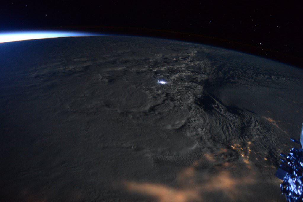
Rare #thundersnow visible from @Space_Station in #blizzard2016! Jan. 23, 2016. Credit: NASA/Scott Kelly/@StationCDRKelly
Rare #thundersnow visible from @Space_Station in #blizzard2016! Jan. 23, 2016. Credit: NASA/Scott Kelly/@StationCDRKelly
NEW JERSEY – NASA astronaut Scott Kelly captured a rare and spectacular display of ‘thundersnow’ from space as Snowzilla’s blast pummeled much of the US East Coast this weekend with two feet or more of paralyzing snow from the nations’ capital to New York City and beyond.
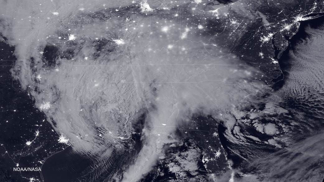
NASA-NOAA's Suomi NPP satellite snapped this image of the approaching blizzard around 2:35 a.m. EST on Jan. 22, 2016 using the Visible Infrared Imaging Radiometer Suite (VIIRS) instrument's Day-Night band. Credit: NOAA/NASA
NASA-NOAA’s Suomi NPP satellite snapped this image of the approaching blizzard around 2:35 a.m. EST on Jan. 22, 2016 using the Visible Infrared Imaging Radiometer Suite (VIIRS) instrument’s Day-Night band. Credit: NOAA/NASA
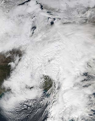
NEW JERSEY- The monstrous ‘Blizzard of 2016’ predicted by weather forecasters for days has struck a wide swath of the US East Coast from the Gulf coast to the Carolinas to New York and soon into New England, with full fury today, Friday, Jan. 22.
NASA and NOAA satellites are tracking the storm which is already inundating the biggest population centers, affecting some 85 million people in 20 states up and down the Atlantic Coast, as it moves in a northeasterly direction.
This afternoon, NASA and NOAA released a series of eyepopping satellite images showing the massive extent of the storm, which may drop historic amounts of snow on Washington DC and other cities over the next 24 to 48 hours.
The two agencies released a particularly striking image, shown above, showing the storm swarming over virtually the entire eastern half of the continental US as it was barreling towards the East coast cites.
It was taken Friday afternoon by the NASA-NOAA’s Suomi NPP satellite showing the approaching blizzard around 2:35 a.m. EST on Jan. 22, 2016 using the Visible Infrared Imaging Radiometer Suite (VIIRS) instrument’s Day-Night band.
States of Emergency have been declared by Governors of states from the mid-Atlantic to New England, including North Carolina, Virginia, Maryland, New York, Pennsylvania, New Jersey, Kentucky, Georgia, Tennessee, West Virginia, the District of Columbia and the list is growing.
The heaviest snowfall is expected in and around Washington DC with estimates of 24 inches of snow or more. 18 to 24 inches may fall along the metropolitan Northeast corridor on Baltimore, Philadelphia, Trenton and New York City.
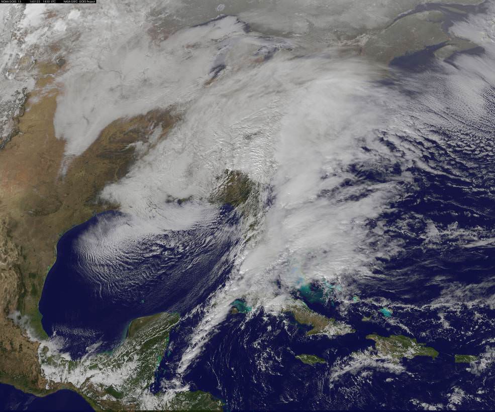
This visible image from NOAA’s GOES-East satellite at 1830 UTC (1:30 p.m. EST) on Jan. 22, 2016 shows the major winter storm now affecting the U.S. East coast. Credits: NASA/NOAA GOES Project
The heavy, blinding snow was already hitting Virginia and Washington by Friday afternoon. Governors, Mayors and Federal officials warned drivers to get off the roads by early Friday afternoon.
Stay off the roadways !!
Widespread treacherous driving with icy roads, sleet, rain, low visibility and whiteout conditions are causing numerous auto accidents as the blizzard bashes the region.
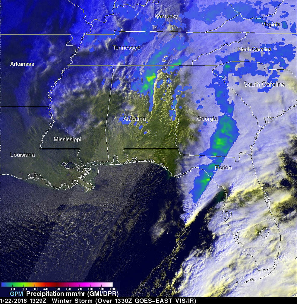
“The winter storm that caused damage during the night along the Gulf Coast has deepened and has started to spread heavy rain, freezing rain, sleet and snow northward into the Mid-Atlantic region. NASA’s GPM and NOAA’s GOES satellites are providing data on rainfall, cloud heights, extent and movement of the storm” wrote NASA’s Rob Gutro in an update on Friday.
On January 22 at 1329 UTC (8:29 a.m. EST) the GPM core satellite saw precipitation falling at a rate of over 64 mm (2.5 inches) per hour in storms over northern Alabama. Credits: SSAI/NASA/JAXA, Hal Pierce
The National Weather Service (NWS) Weather Prediction Center in College Park, Maryland said “An area of low pressure centered over the southeastern U.S. will continue developing into a major winter storm which will impact a large portion of the East Coast from the southern Appalachians through the Mid-Atlantic States from Friday into the weekend. Snowfall totals may exceed 2 feet in portions of these areas, including the Baltimore and Washington D.C. metropolitan areas.”
The monster storm has already caused at least ten deaths. Thousands of motorists are stranded.
High winds up to 55 mph are expected to batter the New Jersey shore, causing significant beach erosion, coastal flooding and property destruction in the same areas devastated by Superstorm Sandy. Thousands of people have been evacuated.
The blizzard has also impacted the US Presidential campaigns and forced New Jersey Governor Chris Christie to temporary cancel campaign appearances in New Hampshire on Friday and Saturday, to deal first hand with the storm back home.
Heavy ice and snow accumulations could cause falling tress resulting in downed power lines and days long power outages during brutally cold temperatures.
Here’s a cool supercomputer animation model:
Video caption: A NASA Center for Climate Simulation supercomputer model that shows the flow of #Blizzard2016 thru Sunday, January 24, 2015. Credit: NASA
Many airports have been closed and some seven thousand flights have also been canceled.
The storm is expected to last into Sunday, Jan. 24
Looking massive from space…. This view of the winter storm over the eastern United States was captured on Friday, January 22, 2016 at 1:55 pm ET via the Visible Infrared Imaging Radiometer Suite (VIIRS) instrument on the Suomi NPP satellite. Credit: NASA/Goddard/Suomi NPP/VIIRS
Stay tuned here for Ken’s continuing Earth and Planetary science and human spaceflight news.
SpaceX Falcon 9 First stage approaches center of landing droneship in Pacific Ocean. Credit: SpaceX
SpaceX Falcon 9 first stage tips over and explodes on Pacific ocean droneship after landing leg fails to lock in place on Jan 17, 2016. Credit: SpaceX
See landing video below
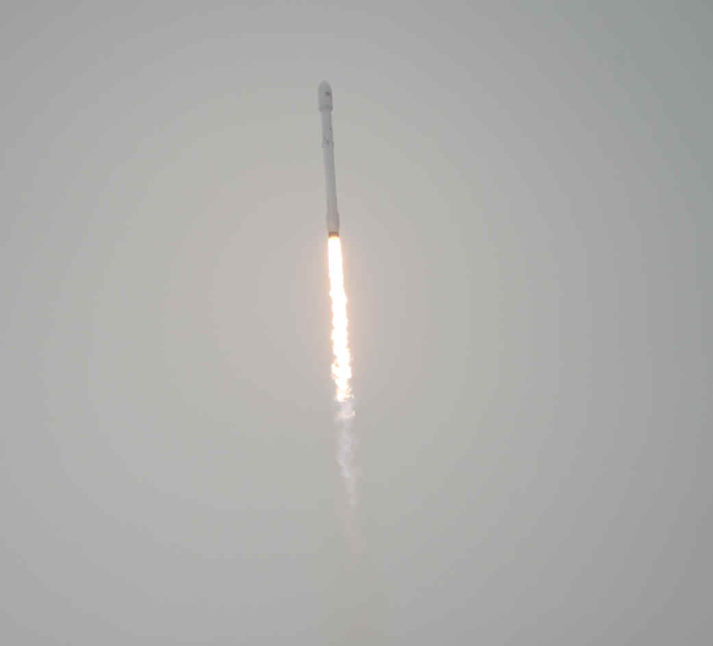
The SpaceX Falcon 9 rocket is seen as it launches from Vandenberg Air Force Base Space Launch Complex 4 East with the Jason-3 spacecraft onboard, , Sunday, Jan. 17, 2016, Vandenberg Air Force Base, California. Jason-3, an international mission led by the National Oceanic and Atmospheric Administration (NOAA), will help continue U.S.-European satellite measurements of global ocean height changes. Photo Credit: (NASA/Bill Ingalls)
The SpaceX Falcon 9 rocket is seen as it launches from Vandenberg Air Force Base Space Launch Complex 4 East with the Jason-3 spacecraft onboard, Sunday, Jan. 17, 2016, Vandenberg Air Force Base, California. Jason-3, an international mission led by the National Oceanic and Atmospheric Administration (NOAA), will help continue U.S.-European satellite measurements of global ocean height changes. Photo Credit: (NASA/Bill Ingalls)
The weather forecast is outstanding! And you can watch all the excitement live!
The primary goal is to deliver Jason-3 to low Earth orbit, where it will gather global measurements of ocean topography, or wave heights, using radar altimitry. These data provide scientists with essential information about global and regional changes in the Earth’s seas such as tracking sea level rise that threatens the resilience of coastal communities and the health of our environment. Continue reading “SpaceX Launching NASA Jason-3 Ocean Surveillance Satellite Jan. 17; with Barge Rocket Landing – Watch Live”
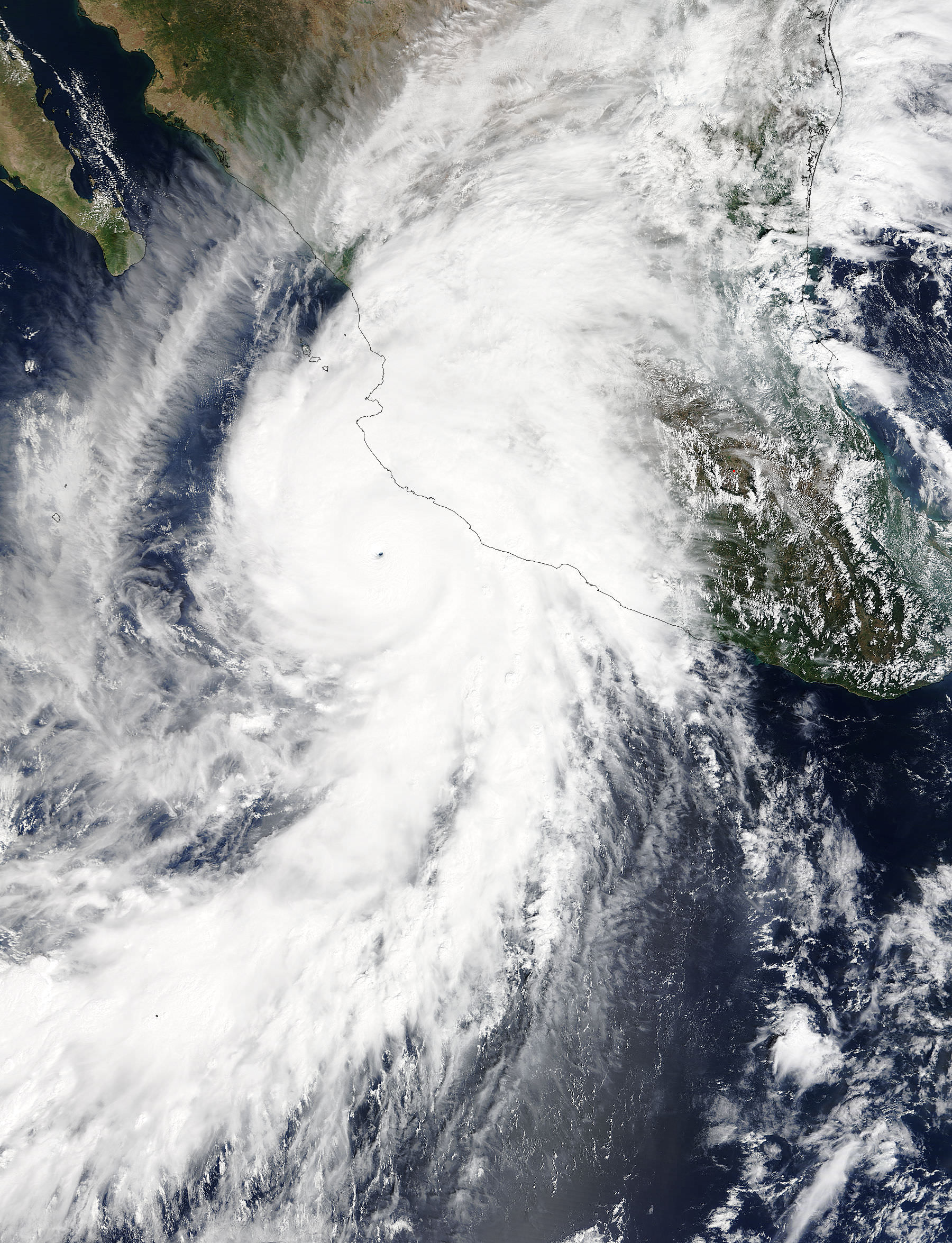
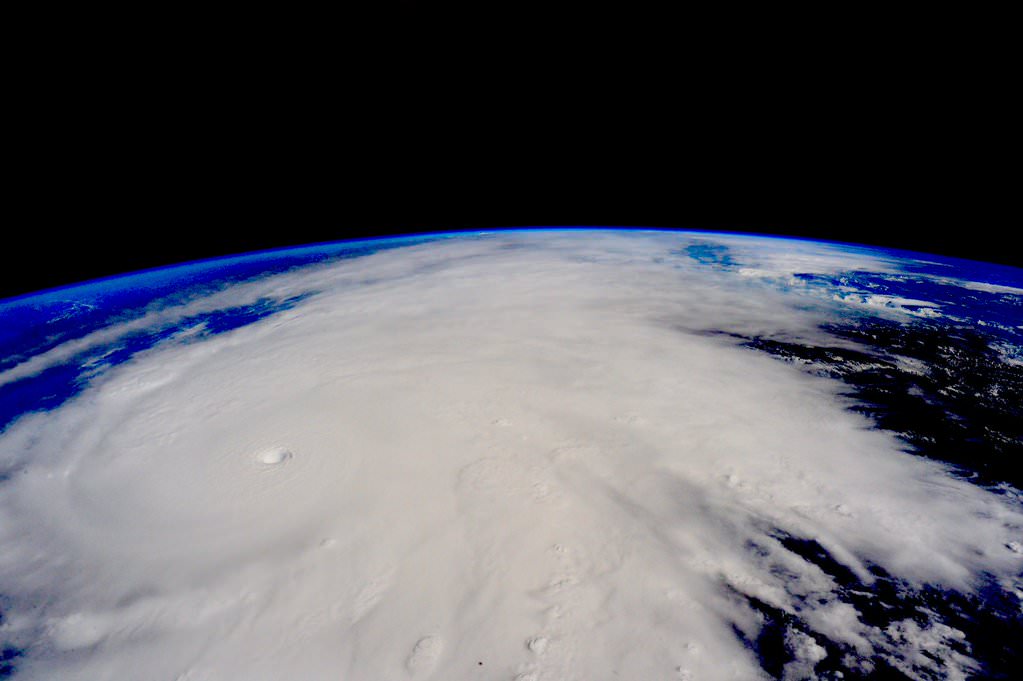
“Hurricane #Patricia approaches #Mexico. It's massive. Be careful” in this image taken by NASA astronaut Scott Kelly aboard the ISS on Oct. 23, 2015. Credit: NASA/Scott Kelly
“Hurricane #Patricia approaches #Mexico. It’s massive. Be careful” in this image taken by NASA astronaut Scott Kelly aboard the ISS on Oct. 23, 2015. Credit: NASA/Scott Kelly
More images and videos below[/caption]
Hurricane Patricia, the strongest storm in recorded history with winds exceeding 190 mph (305 km/h) is right now menacing millions in Mexico after suddenly intensifying with little warning over the past day, threatening widespread catastrophic destruction as it barrels towards frightened residents along the nations Pacific coast and makes landfall this evening, Friday, Oct. 23.
Other NASA and NOAA weather satellites are actively monitoring and measuring the strongest storm on the planet right now.
“Hurricane #Patricia approaches #Mexico. It’s massive. Be careful,” Kelly wrote on his twitter account with a pair of images taken from the ISS.
Patricia unexpectedly intensified quite rapidly to a Category 5 storm from a tropical storm in the space of just 24 hours from yesterday to today with the significant potential for loss of life and likely widespread catastrophic damage.
This morning Patricia had sustained winds of 190 mph (305 km/h) , on the Saffir-Simpson Hurricane Wind Scale, with gusts up to 235 mph. That’s comparable to an EF-4 tornado, but its much wider.
Weather forecasters say that unusually warm waters, possibly from the current El Niño weather pattern may be causing the rapid intensification of the storm to unprecedented power never before seen.
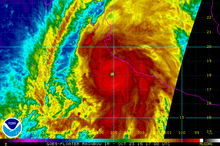
On Oct. 23 at 17:30 UTC (1:30 p.m. EDT) NASA’s Terra satellite saw the eastern quadrant of Hurricane Patricia over Mexico and the storm’s pinhole eye. Credits: NASA’s Goddard MODIS Rapid Response Team
“Hurricane #Patricia looks menacing from @space_station. Stay safe below,” tweeted Kelly, who just broke the American record for most time spent in space.
Patricia is making landfall near the tourist resort of Puerto Vallarta, the town of Cuixmala and the city of Manzanillo along Mexico’s Pacific coast, as it slightly weakens to 165 mph (265 km/h) with destructive force.
Here is the latest Hurricane Patricia animation from NOAA:
Patricia is the most powerful storm ever to make landfall and many millions live in its path that is expected to track eastwards across inland areas of Mexico and then move up into the United States at Texas with flooding rains.
The Mexican government has warned millions to take shelter to evacuate. Over 15000 tourists have been evacuated from Puerto Vallarta to other regions. But the effort was hampered since the airport has been closed.
Catastrophic destruction to homes, businesses and infrastructure is feared.
Some 10 to 20 inches of rain is expected along the coast, causing mudslides across Mexico.
Waves heights exceeding 30 feet are also expected.
Heavy rains and flash flooding will continue into the US with the heaviest downpours expected in Texas and Louisiana.
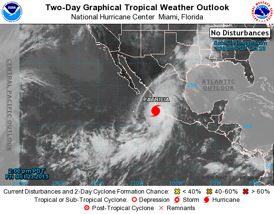
Hurricane Patricia on Oct. 23, 2015 from the National Hurricane Center
Here’s the 7 PM CDT advisory from the National Hurricane Center:
“EXTREMELY DANGEROUS HURRICANE PATRICIA MOVING FARTHER INLAND OVER SOUTHWESTERN MEXICO”
“The center of Hurricane Patricia was located near latitude 19.5 North, longitude 104.9 West. Patricia ismoving toward the north-northeast near 15 mph (24 km/h) and this motion is expected to continue with some increase in forward speed tonight and Saturday. On the forecast track, the center of Patricia should continue to move inland over southwestern Mexico.
Patricia is expected to move quickly north-northeastward across western and northern Mexico through Saturday.
Satellite images indicate that Patricia has continued to weaken, and maximum sustained winds are estimated to be near 160 mph (260 km/h) with higher gusts. Patricia is a category 5 hurricane on the Saffir-Simpson Hurricane Wind Scale. Patricia is forecast to rapidly weaken over the mountains of Mexico and dissipate on Saturday.
Hurricane force winds extend outward up to 35 miles (55 km) from the center and tropical storm force winds extend outward up to 175 miles (280 km).
The estimated minimum central pressure is 924 mb (27.29 inches).”
Here’s a video of Hurricane Patricia from the ISS taken today, Oct 23, 2015.
Video caption: Outside the International Space Station, cameras captured dramatic views of Hurricane Patricia at 12:15 p.m. EDT on October 23, 2015 as the mammoth system moved north at about 10 mph, heading for a potentially catastrophic landfall along the southwest coast of Mexico sometime during the day, according to the National Hurricane Center. Packing winds of 200 miles per hour, Patricia is the strongest in recorded history in the southeastern Pacific Ocean. The National Hurricane Center says that once Patricia crosses the Mexican coast it should weaken quickly and dissipate Oct. 24 due to upper level winds and mountainous terrain, but likely will introduce copious amounts of rainfall to the Texas coast through the weekend. Credit: NASA
Stay tuned here for Ken’s continuing Earth and planetary science and human spaceflight news.
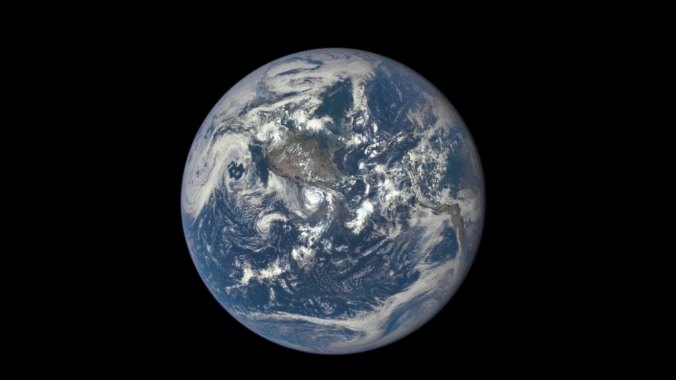
Earth rotates through an entire day as captured in this animation of 22 still images taken on Sept. 17, 2015 by NASA’s Earth Polychromatic Imaging Camera (EPIC) camera on the Deep Space Climate Observatory (DSCOVR) spacecraft. Credits: NASA
The EPIC camera, which stands for Earth Polychromatic Imaging Camera (EPIC), is located a million miles away on the DSCOVR real time space weather monitoring satellite and is designed to take full disk color images of the sunlit side of our home planet multiple times per day.
The EPIC NASA images are literally just a finger tip away, after a 17 year wait to get the satellite into the launch queue since it was first proposed by former VP Al Gore. They are all easily viewed at NASA’s new EPIC camera website which went online today, Monday, October 19, 2015.
This EPIC image was taken on Oct.17 and shows the Australian continent and a portion of Asia.
EPIC image taken on Oct. 17, 2015 showing the continent of Australia and a portion of Asia. Credit: NASA
An annotated guide map illustration identifying the visible land masses accompanies each EPIC image and follows along as the Earth rotates daily.
What a great geography learning tool for student classrooms worldwide!
Annotated guide map identifying the visible land masses accompanies each EPIC image. Credit: NASA
DSCOVR is a joint mission between NOAA, NASA, and the U.S Air Force (USAF) that is managed by NOAA. The satellite and science instruments were provided by NASA and NOAA.
EPIC is a four megapixel CCD camera and telescope mounted on DSCOVR and orbiting around the L1 Lagrange Point – a neutral gravity point that lies on the direct line between Earth and the sun.
NASA says that once per day they will post “at least a dozen new color images of Earth acquired from 12 to 36 hours earlier” taken by the agency’s EPIC camera. The EPIC images will be stored in an archive searchable by date and continent.
The image sequence will show “the Earth as it rotates, thus revealing the whole globe over the course of a day.”
“The effective resolution of the DSCOVR EPIC camera is somewhere between 6.2 and 9.4 miles (10 and 15 kilometers),” said Adam Szabo, DSCOVR project scientist at NASA’s Goddard Space Flight Center, Greenbelt, Maryland, in a statement.
“The color Earth images are created by combining three separate single-color images to create a photographic-quality image equivalent to a 12-megapixel camera. The camera takes a series of 10 images using different narrowband filters — from ultraviolet to near infrared — to produce a variety of science products. The red, green and blue channel images are used to create the color images. Each image is about 3 megabytes in size.”
EPIC will capture “a constant view of the fully illuminated Earth as it rotates, providing scientific observations of ozone, vegetation, cloud height and aerosols in the atmosphere.”
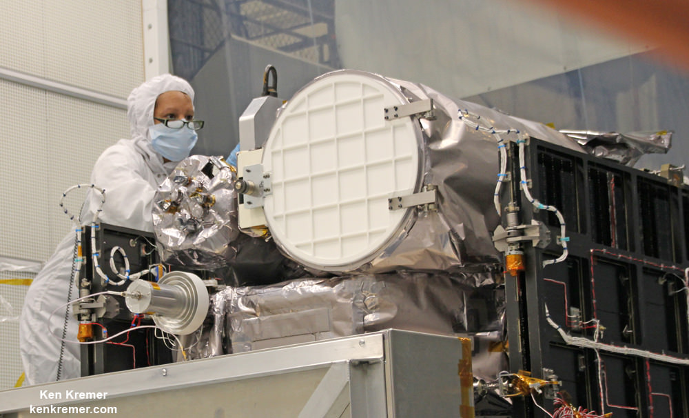
Technician works on NASA Earth science instruments and Earth imaging EPIC camera (white circle) housed on NOAA/NASA Deep Space Climate Observatory (DSCOVR) inside NASA Goddard Space Flight Center clean room in November 2014. Credit: Ken Kremer/kenkremer.com
The couch sized probe was launched atop a SpaceX Falcon 9 on Feb. 11, 2015 from Cape Canaveral, Florida, to start the million mile journey to its deep space observation post at L1. The rocket was funded by the USAF.
The primary goal of the $340 million DSCOVR satellite is to monitor the solar wind and aid very important forecasts of space weather at Earth from L1.
L1 is located 1.5 million kilometers (932,000 miles) sunward from Earth. At L1 the gravity between the sun and Earth is perfectly balanced and the DSCOVR satellite orbits about that spot just like a planet.
The mission is vital because its solar wind observations are crucial to maintaining accurate space weather forecasts to protect US infrastructure such as power grids, aviation, planes in flight, all types of Earth orbiting satellites for civilian and military needs, telecommunications, ISS astronauts and GPS systems.
This animation shows images of the far side of the moon, illuminated by the sun, as it crosses between the DISCOVR spacecraft’s Earth Polychromatic Imaging Camera (EPIC) camera and telescope, and the Earth – one million miles away. Credit: NASA/NOAA
DSCOVR was first proposed in 1998 by then US Vice President Al Gore as the low cost ‘Triana’ satellite to take near continuous views of the Earth’s entire globe to feed to the internet as a means of motivating students to study math and science.
It was also dubbed “Goresat.”
The probe was eventually resurrected and partially rebuilt at NASA Goddard Space Flight Center as a much more capable Earth science satellite that would also conduct the space weather observations.
But Triana was shelved for purely partisan political reasons and the satellite was placed into storage at NASA Goddard.
Thus the practical and teachable science and daily scenes of the gorgeously rotating Earth were lost – until now!
Former VP Al Gore was clearly delighted with today’s launch of NASA’s EPIC website in this pair of tweets:
“Today @NASA launched its site for #DSCOVR’s daily images. I look forward to seeing more from #DSCOVR,” tweeted Al Gore.
“DSCOVR’s site displaying new daily images of Earth from L1 was launched today! Congratulations to all those who made this happen!”
Stay tuned here for Ken’s continuing Earth and planetary science and human spaceflight news.
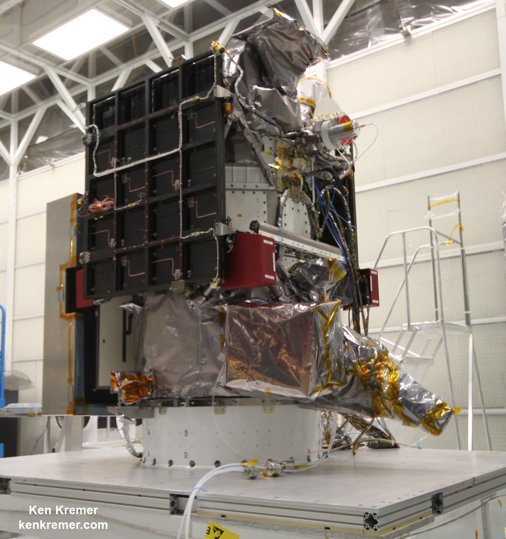
NOAA/NASA Deep Space Climate Observatory (DSCOVR) undergoes processing in NASA Goddard Space Flight Center clean room. Solar wind instruments at right. DSCOVER launched in February 2015 atop SpaceX Falcon 9 rocket. Credit: Ken Kremer/kenkremer.comNOAA/NASA/USAF Deep Space Climate Observatory (DSCOVR) undergoes processing in NASA Goddard Space Flight Center clean room. Probe launched in February 2015 atop SpaceX Falcon 9 rocket. Credit: Ken Kremer/kenkremer.com
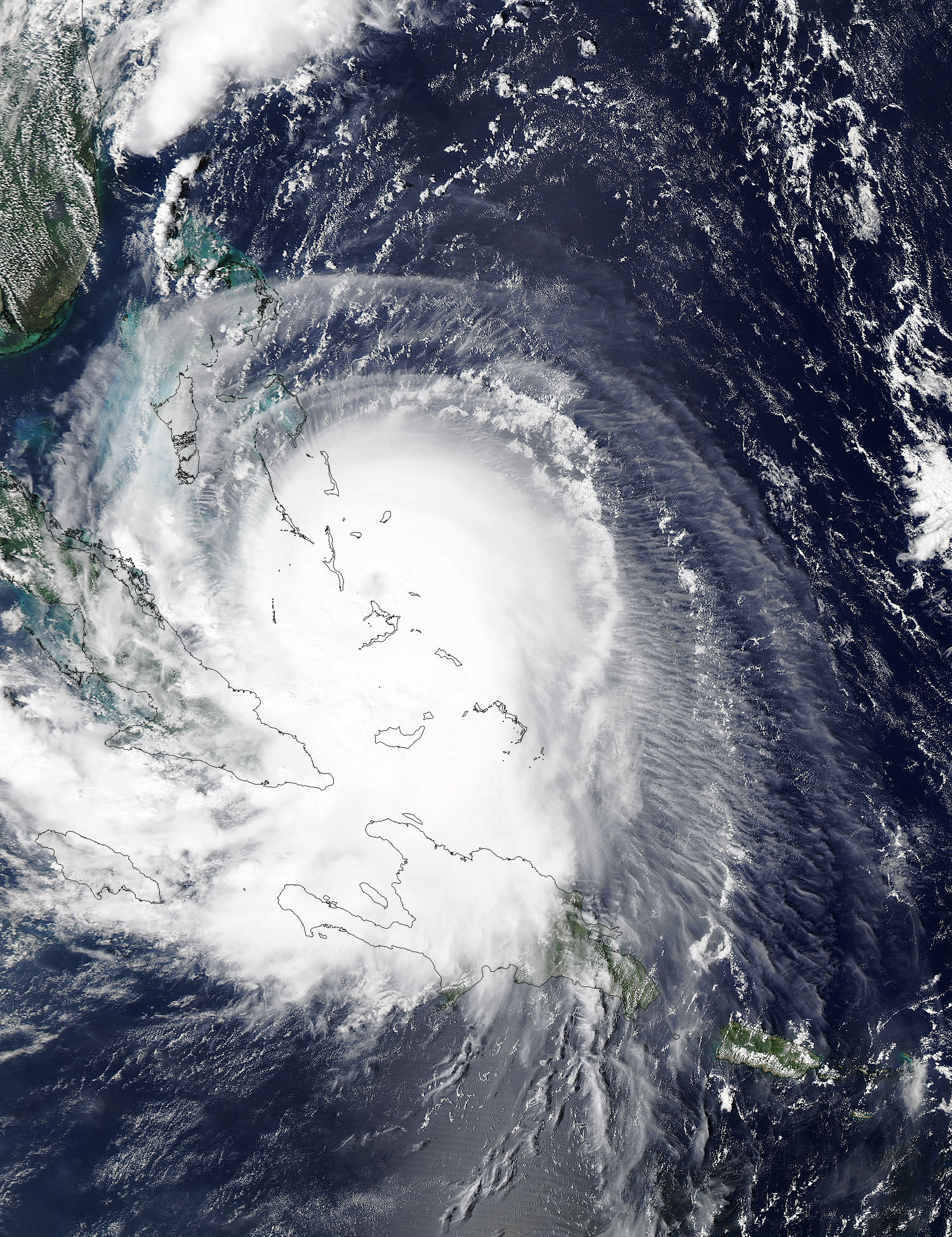
Hurricane Joaquin captured on Oct. 2, 2015 by NASA Astronaut Scott Kelly from the International Space Station. Credit: NASA/Scott Kelly
As the powerful category 4 Hurricane Joaquin was pounding the Bahamas and packing winds of over 130 mph, NASA astronaut Scott Kelly captured a stunning photo of Joaquin on Friday morning, Oct. 2 from his perch aboard the International Space Station (ISS). As of today, Oct. 3. Joaquin has gained strength to 150 mph and is a borderline Cat 5 storm!
Kelly’s spectacular storm photo shows the eye of Hurricane Joaquin over the Caribbean and off the US eastern seaboard with the limb of the Earth and our atmosphere in beautiful detail.
Huge thunderstorms can been off to the north of the immense category 4 storm.
And as of today, Saturday, Oct. 3, Hurricane Joaquin has further strengthened and is now packing maximum sustained winds of 150 MPH or 240 KM/H, according to the latest advisory issued by the National Hurricane Center (NHC) as of 5 p.m. EDT.
Kelly posted the Oct. 2 photo of Joaquin with this caption on his twitter account:
“Early morning shot of Hurricane #Joaquin from @space_station before reaching #Bahamas. Hope all is safe. #YearInSpace.”
Two of the stations solar panels are seen in the photo as well as portions of the US east coast including Florida.
The latest NHC forecast shows Joaquin veering away from the US East Coast. But it’s still creating hurricane force winds and high waves that is threatening Bermuda.
“SEVERE HURRICANE JOAQUIN THREATENING BERMUDA,” said the NHC today.
It is moving northeast at 45 degrees at 17 MPH or 28 KM/H.
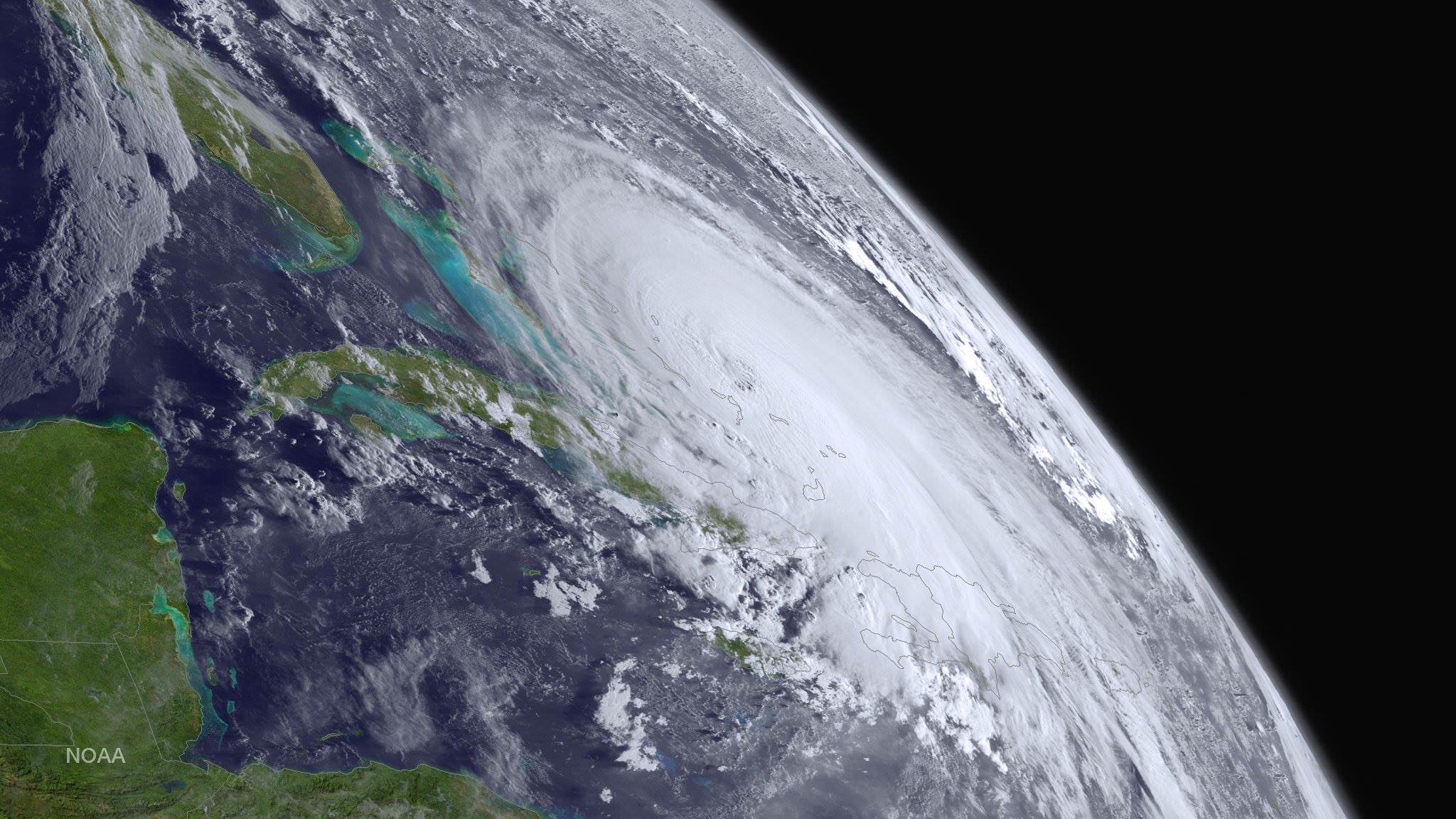
Kelly snapped another telling view of Joaquin on Thursday, Oct. 1 showing the Bahamas and Miami in the field of view.
Kelly tweeted; “#HurricaneJoaquin churns over the #Bahamas with #Miami in the field of view from @Space_Station.”
#HurricaneJoaquin churns over the #Bahamas with #Miami in the field of view from @Space_Station #YearInSpace. Credit: NASA/Scott Kelly
Scott Kelly is a member of the first ever 1 year ISS mission crew comprising Kelly and Russian cosmonaut Mikhail Kornienko.
They arrived at the ISS in March and had just reached the midpoint of their nearly 12 month stay aimed at conducting research to explore the impact of long term stays in space on the human body and aid NASA’s long term plans for a human‘Journey to Mars’ in the 2030s.
NASA and NOAA satellites are keeping constant watch on the progress of the powerful Hurricane Joaquin, that earlier had the potential to barrel towards tens of millions of US coastal residents.
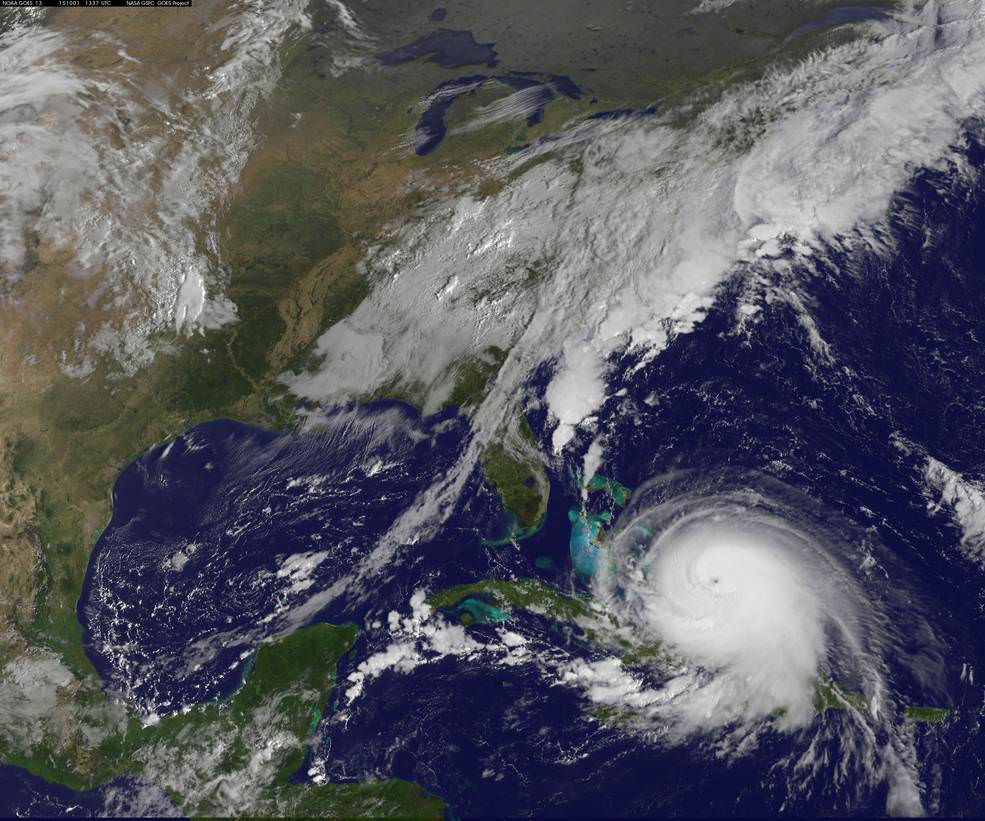
Here’s another stunning view of Hurricane Joaquin taken by the GOES-West satellite on Oct. 1.
This stunning image of Hurricane Joaquin is from NOAA’s GOES West satellite on Oct. 1 2015. Many portions of the eastern U.S. are currently experiencing heavy rains and gusty winds associated with a frontal system. Credit: NOAA
This visible image from NASA’s Aqua satellite shows Hurricane Joaquin over Bahamas on Oct. 1.
NASA’s Aqua satellite captured this visible image of Hurricane Joaquin over Bahamas on Oct. 1 at 17:55 UTC (1:55 p.m. EDT). Credits: NASA Goddard MODIS Rapid Response Team
Stay tuned here for Ken’s continuing Earth and planetary science and human spaceflight news.
NOAA's GOES-East satellite captured this visible image of Hurricane Joaquin affecting the Bahamas on Thursday, Oct. 1 at 1255 UTC. Credits: NASA/NOAA GOES Project
Video caption: This animation of images captured from September 29 to October 1, 2015 from NOAA’s GOES-East satellite shows Hurricane Joaquin become a major hurricane in the Bahamas. Credits: NASA/NOAA GOES Project
NEW JERSEY – A wide swath of the US East Coast is bracing for impact in the coming days as ‘Hurricane Joaquin’ strengthened to a major and dangerous Category 4 storm, today, Thursday, Oct. 1, as NASA and NOAA satellites keep constant watch as it barrels potentially towards tens of millions of coastal residents.
Joaquin is already packing winds exceeding 130 mph with even higher wind gusts as the storm continues to strengthen at this hour and the pressure is decreasing. See the latest Hurricane Joaquin animation and imagery from NASA and NOAA, above and below.
A ULA Atlas V is slated to lift off Friday from Cape Canaveral Air Force Station in Florida at 6:08 a.m. EDT with the Morelos-3 communications satellite for Mexico, before the hurricane gets closer to Florida.
The National Hurricane Center declared Joaquin had intensified into a massive Category 4 hurricane on the Saffir-Simpson Wind Scale, as of 2 PM EDT today, Oct. 1.
You can watch the launch on ULA’s live webcast starting at 5:48 a.m. Oct 2: http://www.ulalaunch.com
The governors of three states – New Jersey, Virginia and North Carolina – have already declared ‘States of Emergency’ in anticipation of potentially destructive winds, potentially life threatening drenching rains and floods, downed power lines and ocean rip currents with high waves in local areas.
Multiple NASA and NOAA satellites are intensively and continuously observing Joaquin, and are providing absolutely critical data to forecasters and government officials with the most current and best information available.
NASA’s GPM, Terra and NPP-Suomi satellites and NOAA’s GOES-East satellite are tracking Joaquin and have seen powerful thunderstorms today which indicates continued strengthening.
At this time we still don’t whether the US eastern seaboard will suffer a major hit but officials are taking no chances after suffering through Superstorm Sandy which caused many deaths, widespread power outages and billions and billions of dollars of damage – from which we are still recovering.
Joaquin is currently over The Bahamas in the Caribbean and is expected to make a sharp right turn on Friday Oct 2 and head northwards to the east coast and the Atlantic Ocean. It could start impacting the Carolinas and regions further north as soon as Sunday, Oct. 4, based on current forecasts, and drop double digits inches of torrential rainfall.
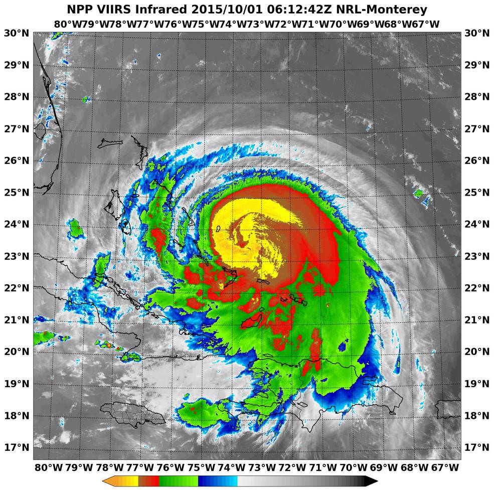
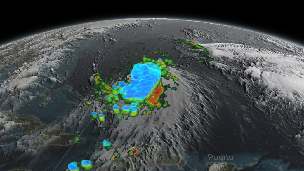
NASA-NOAA’s Suomi NPP satellite passed over Joaquin at 06:10 UTC (2:10 a.m. EDT) on Oct. 1 as it was strengthening from a Category 2 to a Category 3 hurricane. It’s now a Category 4. Imagery showed cloud top temperatures colder than -63F/-53C (yellow). Credits: NRL/NASA/NOAA
Its pounding the Bahamas right now and is creating a disaster with hurricane force winds and heavy rainfall, say weather forecasters, as it remains over the island for some 24 hours or more and may drop over 10 inches of rain.
But there is a very wide cone of uncertainly of where it could hit as the possible storm track extends from the Carolinas to Maine. It may or may not directly impact the eastern US. The storm may shift to the right and spare the east coast. But no one knows at this time.
Some areas on the US East coast stretching from Virginia to Maine have already suffered from torrential rains and severe flooding from an unrelated storm the past few days and also right now today, Thursday.
So the grounds are already saturated in parts of the Carolina’s, Virginia, Maine and elsewhere.
NASA/JAXA’s GPM satellite provided a 3-D side view of Tropical Storm Joaquin on Sept. 29 showing the internal precipitation structure. The areas in blue are frozen precipitation. Areas in green and red are liquid precipitation. Credits: Scientific Visualization Studio, NASA’s Goddard Space Flight Center
Coastal flood warnings and watches are already in effect in many areas along the eastern seaboard where local areas could be drenched by some 12 to 18 inches of additional rain which could fall even before the hurricane hits.
Significant beach erosion has already occurred in the Carolinas over the past few days and more is expected up and down the entire coast up to Maine.
And 10 foot high defense berms of sand are being constructed at this moment along miles and miles of the Jersey Shore – areas that suffered devastating damage from Superstorm Sandy.
There is a potential risk of deadly flooding, flash flooding and damage to houses, buildings, businesses, roadways and infrastructure.
“At 2 p.m. EDT (1800 UTC), the center of Hurricane Joaquin was located near latitude 23.0 North, longitude 74.2 West. Joaquin was moving generally southwestward at about 6 mph (9 kph), and the National Hurricane Center forecast a turn toward the northwest and north on Friday, Oct. 2. On the forecast track, the center of Joaquin will move near or over portions of the central Bahamas today and tonight and pass near or over portions of the northwestern Bahamas on Friday, Oct. 2,” according to NASAs Rob Gutro.
The weather forecast for Friday’s launch from Cape Canaveral , Florida is currently 70 percent GO for liftoff of the United Launch Alliance Atlas V rocket at 6:08 a.m. EDT. The Atlas V will launch with the Morelos-3 mission for Mexico’s Secretaria de Comunicaciones y Transportes (Ministry of Communications and Transportation).
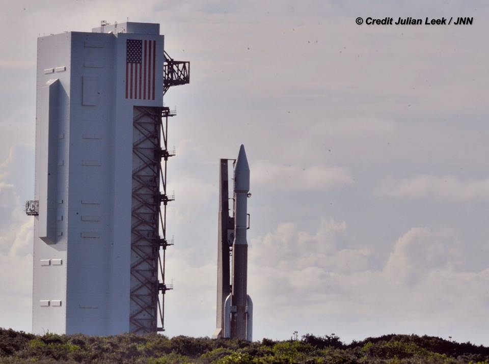
Morelos-3 will be part of the Mexsat constellation of satellites that delivers advanced telecommunications throughout Mexico. United Launch Alliance Atlas V rocket after rollout to Pad 41 at Cape Canaveral Air Force Station, Florida for planned Oct. 2 launch at 6:08 a.m. EDT with the Morelos-3 mission for Mexico’s Ministry of Communications and Transportation. In progress assembly of the commercial crew access tower is seen at right, now under construction for the Boeing Starliner space taxi for astronaut crews launching to the ISS. Credit: Julian Leek
Stay tuned here for Ken’s continuing Earth and planetary science and human spaceflight news.
United Launch Alliance Atlas V rocket during rollout to Space Launch Complex-41 at Cape Canaveral Air Force Station, Florida on Oct. 1 for planned Oct. 2 launch at 6:08 a.m. EDT with the Morelos-3 mission for Mexico’s Ministry of Communications and Transportation. Credit: Julian Leek