The rim of Tooting Crater on Mars, rendered from HiRISE data using Autodesk Maya and Adobe Photoshop. Credit: NASA/JPL/University of Arizona/USGS/image editing by Kevin Gill.
By day, Kevin Gill is a software engineer at the Jet Propulsion Laboratory. But on nights and weekends he takes data from spacecraft and turns them into scenes that can transport you directly to the surface of Mars.
Gill is one of many so-called “amateur” image editing enthusiasts that take real, high-resolution data from spacecraft and create views that can make you feel like you are standing on the surface of Mars, or out flying around the Solar System.
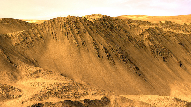
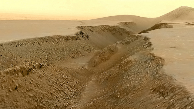
Gasa Crater on Mars. Rendered using Autodesk Maya and Adobe Photoshop. HiRISE data processed using HiView and gdal. Credit: NASA/JPL/University of Arizona/USGS/image editing by Kevin Gill.
Some of the best data around for these purposes come from the HiRISE camera on board the Mars Reconnaissance Orbiter. Data known as Digital Terrain Model (DTM) files, the HiRISE DTMs are made from two or more images of the same area of a region on Mars, taken from different angles. This data isn’t just for making stunning images or amazing movies. For scientists, DTMs are very powerful research tools, used to take measurements such a elevation information and model geological processes.
So, just how do you go from this DTM image from HiRISE:
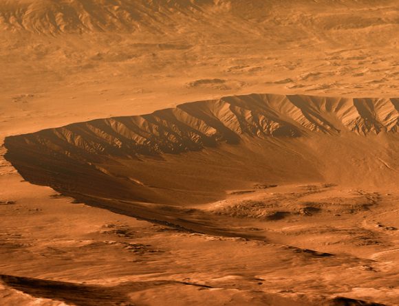
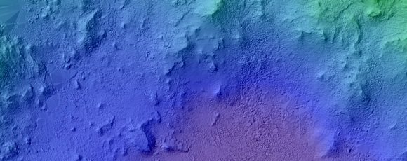
DTM image of the Central Peak of Elorza Crater on Mars. Credit: NASA/JPL/University of Arizona/USGS
To this amazing image?
Martian sunrise over the Central Peak of Elorza Crater. Rendered using Autodesk Maya and Adobe Photoshop. HiRISE data processed using HiView and gdal. Credit: NASA/JPL/University of Arizona/USGS/image editing by Kevin Gill
I’m going to let Kevin explain it:
To prep the data, I use Photoshop (to convert the JP2 file to a TIFF), and then standard GIS tools like gdal (Geospatial Data Abstraction Library) to create textures for 3D modeling. Using Autodesk Maya, I input those into a material as a color texture (orthoimagery) or displacement map (the DTM data).
I connect that material to a NURBS plane (sort of like a polygon mesh) that is scaled similarly to the physical properties of the data. I set up a camera at a nice angle (it takes a number of low-resolution test renders to get an angle I like) and let it render.
Then I just pull that render into Photoshop where I have a series of monochromatic color tints which gives the image it’s Martian feel. For the sky, I use either a sky from a MSL MastCam image or one that I took outside with my cell phone. If I’m using a sky I took with my cell phone, I’ll adjust the colors to make it look more like it would on Mars. If the colors in the image are still boring at this point, I may run a HDR adjustment on it in Photoshop.
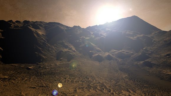
Fissure in the Cerberus region. This false color view of a volcanic fissure in the Cerberus region of Mars was created using a digital terrain model (DTM) from the High Resolution Imaging Science Experiment (HiRISE) camera aboard NASA’s Mars Reconnaissance Orbiter. The horizon was taken from Curiosity Mastcam imagery. Credit: NASA/JPL-Caltech/University of Arizona/ image editing by Kevin Gill.
What all this means is that you can create all these amazing view, plus incredible flyover videos, like this one Kevin put together of Endeavour Crater:
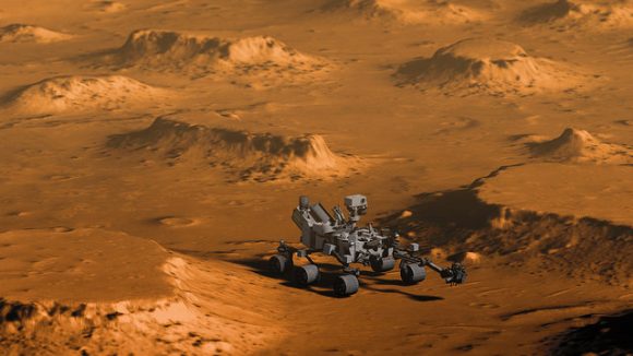
Or you can have some fun and visualize where the Curiosity rover is sitting:
Doin’ Science with Curiosity. Created using HiRIST DTM and Ortho data and NASA model of Curiosity. Rendered using Autodesk Maya and Adobe Photoshop. Curiosity Model: Brian Kumanchik, NASA/JPL-Caltech. Image editing by Kevin Gill.
We’ve written about this type of image editing previously, with the work of the people at UnmannedSpaceflight.com and others. Of course, the image editing software keeps improving, along with all the techniques.
Kevin also wanted to point out the work of other image editing enthusiast, Sean Doran.
“Sean’s work is resulting in views similar to mine,” Kevin said via email. “I know he’s using a process very different from mine, but we are thinking along the same lines in what we want out of the end product. His are quite impressive.”
For example, here is a flyover video of the Opportunity rover sitting along the rim of Endeavour Crater:
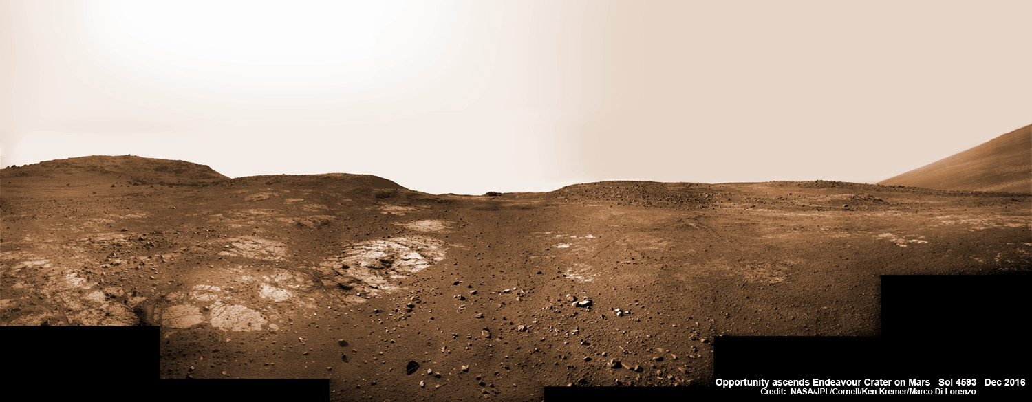
13 Years on Mars! On Christmas Day 2016, NASA’s Opportunity rover scans around vast Endeavour crater as she ascends steep rocky slopes on the way to reach a water carved gully along the eroded craters western rim. This navcam camera photo mosaic was assembled from raw images taken on Sol 4593 (25 Dec. 2016) and colorized. Credit: NASA/JPL/Cornell/Ken Kremer/kenkremer.com/Marco Di Lorenzo
13 Years on Mars!
On Christmas Day 2016, NASA’s Opportunity rover scans around vast Endeavour crater as she ascends steep rocky slopes on the way to reach a water carved gully along the eroded craters western rim. This navcam camera photo mosaic was assembled from raw images taken on Sol 4593 (25 Dec. 2016) and colorized. Credit: NASA/JPL/Cornell/Ken Kremer/kenkremer.com/Marco Di Lorenzo
NASA’s truly outstanding Opportunity rover continues “making new discoveries about ancient Mars” as she commemorates 13 Years since bouncing to a touchdown on Mars, in a feat that is “truly amazing” – the deputy chief scientist Ray Arvidson told Universe Today exclusively.
“Reaching the 13th year anniversary with a functioning rover making new discoveries about ancient Mars on a continuing basis is truly amazing,” Ray Arvidson, Opportunity Deputy Principal Investigator of Washington University in St. Louis, told Universe Today.
Put another way Opportunity is 13 YEARS into her 3 MONTH mission! And still going strong!
During the past year the world famous rover discovered “more extensive aqueous alteration within fractures and more mild alteration within the bedrock outcrops” at Endeavour crater, Arvidson elaborated.
And now she is headed to her next target – an ancient water carved gully!
The gully is situated about 0. 6 mile (1.6 km) south of the robots current location.
But to get there she first has to heroically ascend steep rocky slopes inclined over 20 degrees along the eroded craters western rim – and it’s no easy task! Slipping and sliding along the way and all alone on difficult alien terrain.
Furthermore she is 51 times beyond her “warrantied” life expectancy of merely 90 Sols promised at the time of landing so long ago – roving the surface of the 4th rock from the Sun during her latest extended mission; EM #10.
How was this incredible accomplishment achieved?
“Simply a well-made and thoroughly tested American vehicle,” Arvidson responded.
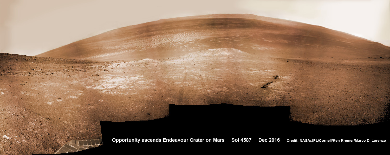
NASA’s Opportunity rover scans around and across to vast Endeavour crater on Dec. 19, 2016, as she climbs steep slopes on the way to reach a water carved gully along the eroded craters western rim. Note rover wheel tracks at center. This navcam camera photo mosaic was assembled from raw images taken on Sol 4587 (19 Dec. 2016) and colorized. Credit: NASA/JPL/Cornell/Ken Kremer/kenkremer.com/Marco Di Lorenzo
The six wheeled rover landed on Mars on January 24, 2004 PST on the alien Martian plains at Meridiani Planum -as the second half of a stupendous sister act.
Her twin sister Spirit, had successfully touched down 3 weeks earlier on January 3, 2004 inside 100-mile-wide Gusev crater and survived more than six years.
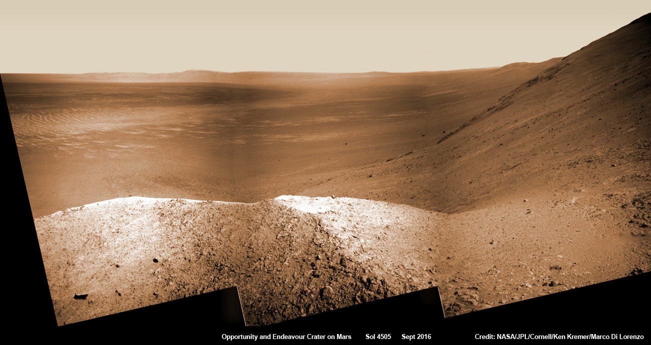
NASA’s Opportunity explores Spirit Mound after descending down Marathon Valley and looks out across the floor of vast Endeavour crater. This navcam camera photo mosaic was assembled from raw images taken on Sol 4505 (25 Sept 2016) and colorized. Credit: NASA/JPL/Cornell/ Ken Kremer/kenkremer.com/Marco Di Lorenzo
Opportunity concluded 2016 and starts 2017 marching relentlessly towards an ancient water carved gully along the eroded rim of vast Endeavour crater – the next science target on her heroic journey traversing across never before seen Red Planet terrains.
Huge Endeavour crater spans some 22 kilometers (14 miles) in diameter.
Throughout 2016 Opportunity was investigating the ancient, weathered slopes around the Marathon Valley location in Endeavour crater. The area became a top priority science destination after the slopes were found to hold a motherlode of ‘smectite’ clay minerals based on data from the CRISM spectrometer circling overhead aboard a NASA Mars orbiter.
The smectites were discovered via extensive, specially targeted Mars orbital measurements gathered by the CRISM (Compact Reconnaissance Imaging Spectrometer for Mars) spectrometer on NASA’s Mars Reconnaissance Orbiter (MRO) – accomplished earlier at the direction of Arvidson.
Opportunity was descending down Marathon Valley the past year to investigate the clay minerals formed in water. They are key to helping determine the habitability of the Red Planet when it was warmer and wetter billions of years ago.
What did Opportunity accomplish scientifically at Marathon Valley during 2016?
“Key here is the more extensive aqueous alteration within fractures and more mild alteration within the bedrock outcrops,” Arvidson explained to me.
“Fractures have red pebbles enhanced in Al and Si (likely by leaching out more soluble elements), hematite, and in the case of our scuffed fracture, enhanced sulfate content with likely Mg sulfates and other phases. Also the bedrock is enriched in Mg and S relative to other Shoemaker rocks and these rocks are the smectite carrier as observed from CRISM ATO data.”
Marathon Valley measures about 300 yards or meters long. It cuts downhill through the west rim of Endeavour crater from west to east – the same direction in which Opportunity drove downhill from a mountain summit area atop the crater rim.
Opportunity has been exploring Endeavour since arriving at the humongous crater in 2011. Endeavour crater was formed when it was carved out of the Red Planet by a huge meteor impact billions of years ago.
“Endeavour crater dates from the earliest Martian geologic history, a time when water was abundant and erosion was relatively rapid and somewhat Earth-like,” explains Larry Crumpler, a science team member from the New Mexico Museum of Natural History & Science.
Opportunity has been climbing up very steep and challenging slopes to reach the top of the crater rim. Then she will drive south to Cape Byron and the gully system.
“We have had some mobility issues climbing steep, rocky slopes. Lots of slipping and skidding, but evaluating the performance of the rover on steep, rocky and soil-covered slopes was one of the approved extended mission objectives,” Arvidson explained.
“We are heading out of Cape Tribulation, driving uphill to the southwest to reach the Meridiani plains and then to drive to the western side of Cape Byron to the head of a gully system.”
What’s ahead for 2017? What’s the importance of exploring the gully?
“Finish up work on Cape Tribulation, traverse to the head of the gully system and head downhill into one or more of the gullies to characterize the morphology and search for evidence of deposits,” Arvidson elaborated.
“Hopefully test among dry mass movements, debris flow, and fluvial processes for gully formation. The importance is that this will be the first time we will acquire ground truth on a gully system that just might be formed by fluvial processes. Will search for cross bedding, gravel beds, fining or coarsening upward sequences, etc., to test among hypotheses.”
How long will it take to reach the gully?
“Months to the gully,” replied Arvidson. After arriving at the top of the crater rim, the rover will actually drive part of the way on the Martian plains again during the southward trek to the gully.
“And we will be driving on the plains to drive relatively long distances with an intent of getting to the gully well before the winter season.”
As of today, Jan 31, 2017, long lived Opportunity has survived 4630 Sols (or Martian days) roving the harsh environment of the Red Planet.
Opportunity has taken over 216,700 images and traversed over 27.26 miles (43.87 kilometers) – more than a marathon.
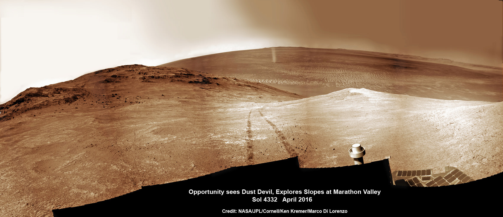
NASA’s Opportunity rover discovers a beautiful Martian dust devil moving across the floor of Endeavour crater as wheel tracks show robots path today exploring the steepest ever slopes of the 13 year long mission, in search of water altered minerals at Knudsen Ridge inside Marathon Valley on 1 April 2016. This navcam camera photo mosaic was assembled from raw images taken on Sol 4332 (1 April 2016) and colorized. Credit: NASA/JPL/Cornell/ Ken Kremer/kenkremer.com/Marco Di Lorenzo
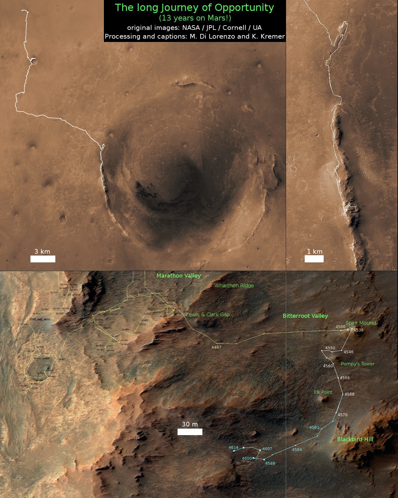
See our updated route map below. It shows the context of the rovers over 13 year long traverse spanning more than the 26 mile distance of a Marathon runners race.
The rover surpassed the 27 mile mark milestone on November 6, 2016 (Sol 4546).
The power output from solar array energy production is currently 416 watt-hours, before heading into another southern hemisphere Martian winter in 2017. It will count as Opportunities 8th winter on Mars.
Meanwhile Opportunity’s younger sister rover Curiosity traverses and drills into the lower sedimentary layers at the base of Mount Sharp.
Stay tuned here for Ken’s continuing Earth and planetary science and human spaceflight news.
13 Year Traverse Map for NASA’s Opportunity rover from 2004 to 2017. This map shows the entire 43 kilometer (27 mi) path the rover has driven on the Red Planet during more than 13 years and more than a marathon runners distance for over 4614 Sols, or Martian days, since landing inside Eagle Crater on Jan 24, 2004 – to current location at the western rim of Endeavour Crater. After descending down Marathon Valley and after studying Spirit Mound, the rover is now ascending back uphill on the way to a Martian water carved gully. Rover surpassed Marathon distance on Sol 3968 after reaching 11th Martian anniversary on Sol 3911. Opportunity discovered clay minerals at Esperance – indicative of a habitable zone – and searched for more at Marathon Valley. Credit: NASA/JPL/Cornell/ASU/Marco Di Lorenzo/Ken Kremer/kenkremer.com
Using its HiRISE camera, the MRO has noted existence of tall networks of ridges on Mars that have diverse origins. Credit: NASA/JPL-Caltech/Univ. of Arizona
Mars has some impressive geological features across its cold, desiccated surface, many of which are similar to featured found here on Earth. By studying them, scientists are able to learn more about the natural history of the Red Planet, what kinds of meteorological phenomena are responsible for shaping it, and how similar our two planets are. A perfect of example of this are the polygon-ridge networks that have been observed on its surface.
One such network was recently discovered by the Mars Reconnaissance Orbiter (MRO) in the Medusae Fossae region, which straddles the planet’s equator. Measuring some 16 story’s high, this ridge network is similar to others that have been spotted on Mars. But according to a survey produced by researchers from NASA’s Jet Propulsion Laboratory, these ridges likely have different origins.
This survey, which was recently published in the journal Icarus, examined both the network found in the Medusae Fossae region and similar-looking networks in other regions of the Red Planet. These ridges (sometimes called boxwork rides), are essentially blade-like walls that look like multiple adjoining polygons (i.e. rectangles, pentagons, triangles, and similar shapes).
Shiprock, a ridge-feature in northwestern New Mexico that is 10 meters (30 feet) tall, which formed from lava filling an underground fracture that resisted erosion better than the material around it did. Credit: NASA
While similar-looking ridges can be found in many places on Mars, they do not appear to be formed by any single process. As Laura Kerber, of NASA’s Jet Propulsion Laboratory and the lead author of the survey report, explained in a NASA press release:
“Finding these ridges in the Medusae Fossae region set me on a quest to find all the types of polygonal ridges on Mars… Polygonal ridges can be formed in several different ways, and some of them are really key to understanding the history of early Mars. Many of these ridges are mineral veins, and mineral veins tell us that water was circulating underground.”
Such ridges have also been found on Earth, and appear to be the result of various processes as well. One of the most common involves lava flowing into preexisting fractures in the ground, which then survived when erosion stripped the surrounding material away. A good example of this is the Shiprock (shown above), a monadrock located in San Juan County, New Mexico.
Examples of polygon ridges on Mars include the feature known as “Garden City“, which was discovered by the Curiosity rover mission. Measuring just a few centimeters in height, these ridges appeared to be the result of mineral-laden groundwater moving through underground fissures, which led to standing mineral veins once the surrounding soil eroded away.
Mineral veins at the “Garden City” site, examined by NASA’s Curiosity Mars rover. Credit: NASA/JPL
At the other end of the scale, ridges that measure around 2 kilometers (over a mile) high have also been found. A good example of this is “Inca City“, a feature observed by the Mars Global Surveyor near Mars’ south pole. In this case, the feature is believed to be the result of underground faults (which were formed from impacts) filling with lava over time. Here too, erosion gradually stripped away the surrounding rock, exposing the standing lava rock.
In short, these features are evidence of underground water and volcanic activity on Mars. And by finding more examples of these polygon-ridges, scientists will be able to study the geological record of Mars more closely. Hence why Kerber is seeking help from the public through a citizen-science project called Planet Four: Ridges.
Established earlier this month on Zooniverse – a volunteer-powered research platform – this project has made images obtained by the MRO’s Context Camera (CTX) available to the public. Currently, this and other projects using data from CTX and HiRISE have drawn the participation of more than 150,000 volunteers from around the world.
By getting volunteers to sort through the CTX images for ridge formations, Kerber and her team hopes that previously-unidentified ones will be identified and that their relationship with other Martian features will be better understood.
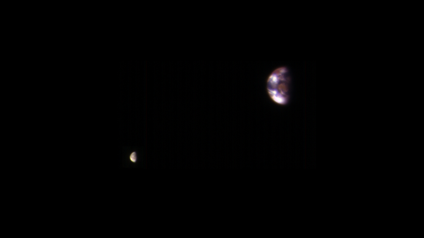
A view of Earth and its Moon, as seen from Mars. It combines two images acquired on Nov. 20, 2016, by the HiRISE camera on NASA's Mars Reconnaissance Orbiter, with brightness adjusted separately for Earth and the moon to show details on both bodies. Credit: NASA/JPL-Caltech/Univ. of Arizona.
The incredible HiRISE camera on board the Mars Reconnaissance Orbiter turned its eyes away from its usual target – Mars’ surface – and for calibration purposes only, took some amazing images of Earth and our Moon. Combined to create one image, this is a marvelous view of our home from about 127 million miles (205 million kilometers) away.
Alfred McEwen, principal investigator for HiRISE said the image is constructed from the best photo of Earth and the best photo of the Moon from four sets of images. Interestingly, this combined view retains the correct positions and sizes of the two bodies relative to each other. However, Earth and the Moon appear closer than they actually are in this image because the observation was planned for a time at which the Moon was almost directly behind Earth, from Mars’ point of view, to see the Earth-facing side of the Moon.
A view of Earth and its Moon, as seen from Mars. It combines two images acquired on Nov. 20, 2016, by the HiRISE camera on NASA’s Mars Reconnaissance Orbiter, with brightness adjusted separately for Earth and the moon to show details on both bodies. Credit: NASA/JPL-Caltech/Univ. of Arizona.
“Each is separately processed prior to combining (in correct relative positions and sizes), so that the Moon is bright enough to see,” McEwen wrote on the HiRISE website. “The Moon is much darker than Earth and would barely show up at all if shown at the same brightness scale as Earth. Because of this brightness difference, the Earth images are saturated in the best Moon images, and the Moon is very faint in the best (unsaturated) Earth image.”
Earth looks reddish because the HiRISE imaging team used color filters similar to the Landsat images where vegetation appears red.
“The image color bandpasses are infrared, red, and blue-green, displayed as red, green, and blue, respectively,” McEwen explained. “The reddish blob in the middle of the Earth image is Australia, with southeast Asia forming the reddish area (vegetation) near the top; Antarctica is the bright blob at bottom-left. Other bright areas are clouds. We see the western near-side of the Moon.”
HiRISE took these pictures on Nov. 20, 2016, and this is not the first time HiRISE has turned its eyes towards Earth.
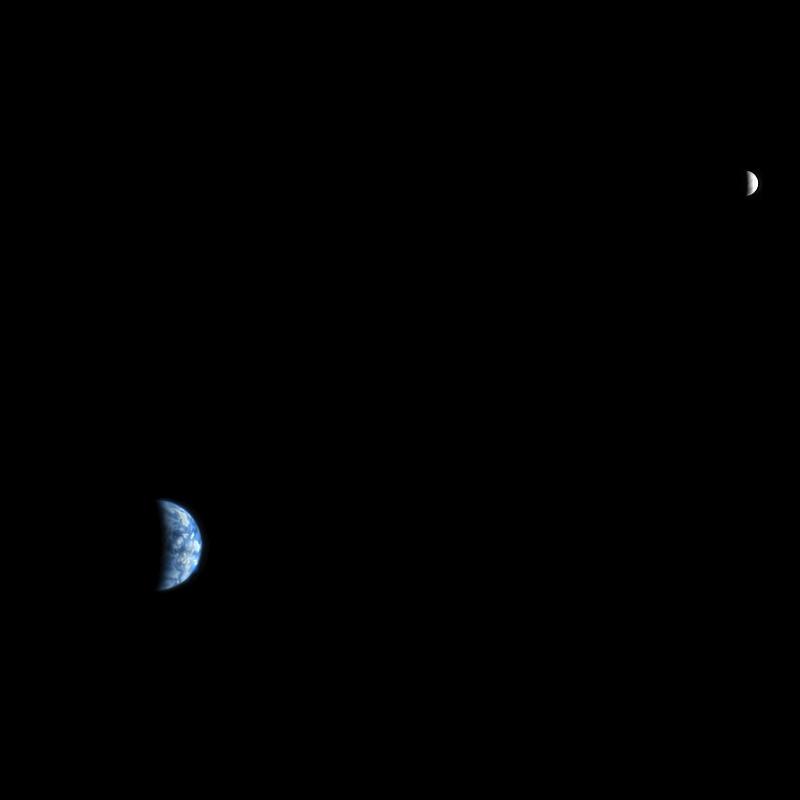
Back in 2007, HiRISE took this image, below, from Mars’ orbit when it was just 88 million miles (142 million km) from Earth. This one is more like how future astronauts might see Earth and the Moon through a telescope from Mars’ orbit.
An image of Earth and the Moon, acquired on October 3, 2007, by the HiRISE camera on NASA’s Mars Reconnaissance Orbiter. Credit: NASA/JPL-Caltech/University of Arizona.
If you look closely, you can make out a few features on our planet. The west coast outline of South America is at lower right on Earth, although the clouds are the dominant features. In fact, the clouds were so bright, compared with the Moon, that they almost completely saturated the filters on the HiRISE camera. The people working on HiRISE say this image required a fair amount of processing to make such a nice-looking picture.
You can see an image from a previous Mars’ orbiter, the Mars Global Surveyor, that took a picture of Earth, the Moon and Jupiter — all in one shot — back in 2003 here.
Artist's impression of geysers at the Martian south polar icecap as southern spring begins. Credit: NASA/JPL-Caltech/Arizona State University/Ron Miller
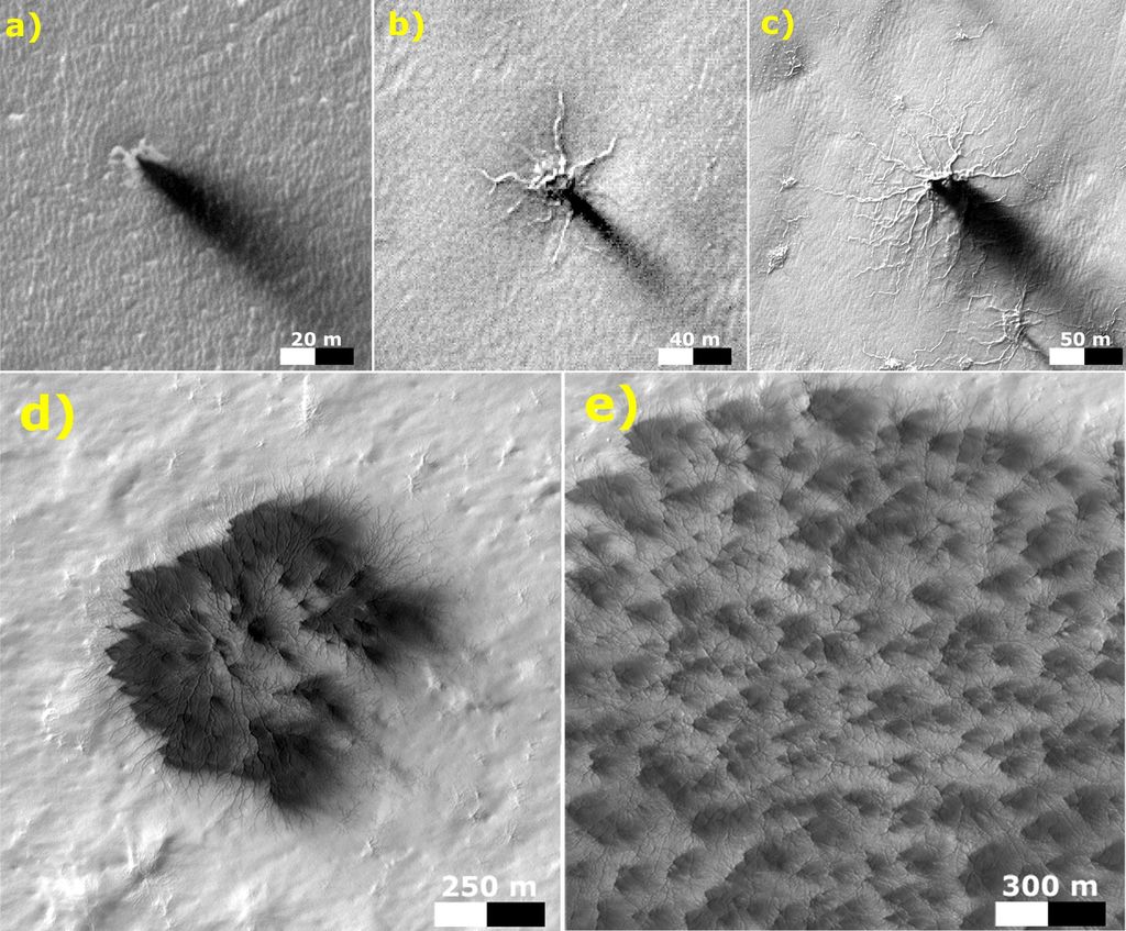
For years, scientists have understood that in Mars’ polar regions, frozen carbon dioxide (aka. dry ice) covers much of the surface during the winter. During the spring, this ice sublimates in places, causing the ice to crack and jets of CO² to spew forth. This leads to the formation of dark fans and features known as “spiders”, both of which are unique to Mars’ southern polar region.
For the past decade, researchers have failed to see these features changing from year-to-year, where repeated thaws have led to their growth. However, using data from the Mars Reconnaissance Orbiter‘s (MRO) HiRISE camera, a research team from the University of Colorado, Boulder and the Planetary Science Institute in Arizona have managed to catch sight of the cumulative growth of a spider for the first time from one spring to the next.
Spiders are so-named because of their appearance, where multiple channels converge on a central pit. Dark fans, on the other hand, are low-albedo patches that are darker than the surrounding ice sheet. For some time, astronomers have been observed these features in the southern polar region of Mars, and multiple theories were advanced as to their origin.
HiRISE images of the Martian landscape, showing outgassing and the formation of dark fans and “spiders”. Credit: NASA/JPL
In 2007, Hugh Kieffer of the Space Science Institute in Boulder, Colorado theorized that the dark fans and spiders were linked, and that both features were the result of spring thaws. In short, during Mars’ spring season – when the southern polar region is exposed to more sunlight – the Sun’s rays penetrates the ice sheets and warm the ground underneath.
This causes gas flows to form beneath the ice that build up pressure, eventually causing the ice to crack and triggering geysers. These geysers deposit mineral dust and sand across the surface downwind from the eruption, while the cracks in the ice grow and become visible from orbit. While this explanation has been widely-accepted, scientists have been unable to observe this process in action.
By using data from the MRO’s High Resolution Imaging Science Experiment (HiRISE), the research team was able to spot a small-channeled troughs in the southern region which persisted and grew over a three year period. In addition to closely resembling spidery terrain, it was in proximity to dark fan sites. From this, they determined that they were witnessing a spider that was in the process of formation.
As Dr. Ganna Portyankina – a researcher from the Laboratory for Atmospheric and Space Physics at the University of Colorado, Boulder, and the lead author on the team’s research paper – explained to Universe Today via email,
“We have observed different changes in the surface caused by CO² jets before. However, they all were either seasonal changes in surface albedo, like dark fans, or they were only short-lived and were gone the next year, like furrows. This time, the troughs have stayed over several years and they develop dendritic-type of extension – right the way we expect the large spiders to develop.”
Spiders trace a delicate pattern on top of the residual polar cap, after the seasonal carbon-dioxide ice slab has disappeared. Next spring, these will likely mark the sites of vents when the CO2 icecap returns. This MOC image is about 2 miles wide. Credit: NASA/JPL/MSSS
Furrows that were similar to the spidery terrain have been spotted at Mars’ north pole in the past, which coincided with a Martian spring. On these occasions, scientists using data from HiRISE instrument reported seeing small furrows on sand dunes, where eruptions had deposited dark fans. However, in what is typical of northern furrows, these were non-persisting annual occurrences, disappearing when summer winds deposited sand in them.
In contrast, the troughs Dr. Portyankina and her team observed in the southern polar region were persistent over a three-year period. During this time, these features extended and developed new “tributaries”, forming a dendritic pattern that resembled a Martian spider. From this, they concluded that the previously-observed northern furrows have the same cause – i.e. sublimation causing outgassing.
However, they also concluded that the northern furrows do not develop over time because of the high-mobility of dune material in the northern polar region. The difference, it seems, comes down to the presence of erosive sand material in the north and south, which creates (or starts) the erosive process that leads to the formation of spider-like troughs – which both kick-stars the process but can also erase it.
“Many locations in the south polar regions with seasonal dark fans show no visible sand deposits,” said Dr. Portyankina. “Dark fans in those locations might be only a mix of regolith and dust, or even just dust on its own – as it is really everywhere on Mars… [T]hose locations that have sand will experience higher erosion simply because there is granular material in the gas flow. Basically, it is old simple sandblasting. This means, it must be easier and faster to carve spiders in those locations.”
Images of dark spots (left) and fans (right) observed on top of the Martian south polar cap taken in southern spring. Credit: NASA/JPL/MSSS
In other words, where sand exists beneath the ice sheet, the ground beneath that is likely to be rockier (i.e. harder)> The formation of spider terrain may thereofre require that the ground beneath the ice be soft enough to be carved, but not so loose that it will refill the channels during a single seasonal cycle. In short, the formation of spidery terrain appears to be dependent upon the difference in surface composition between the poles.
In addition, from the many year’s of HiRISE data that has been accumulated, Dr. Portyankina and her team were also able to gauge the current rate of erosion in Mars’ southern polar region. Ultimately, they estimated that smaller spider-like furrows would require a thousand Martian years (about 1,900 Earth years) in order to become a full-scale spider.
This study is certainly significant, since understanding how seasonal changes and present-day erosion lead to the creation of new topographical features is important when it comes to understanding the processes that shape Mars’ polar regions. As we get closer and closer to the day when crewed missions and even settlement become a reality, knowing how these processes shape the planet will be fundamental to making a go of things on Mars.
A possible 'Recurring Slope Lineae (RSL), dark streaks on slopes that appeared to ebb and flow over time that may or may not be caused by water on Mars. This RSL is in Ceraunius Fossae. Credit: NASA/JPL/University of Arizona.
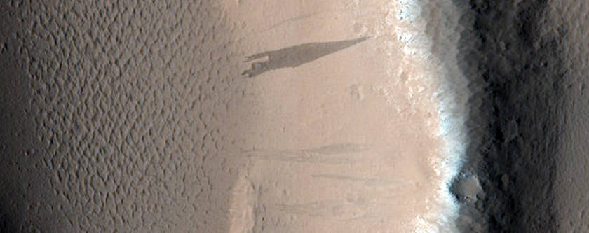
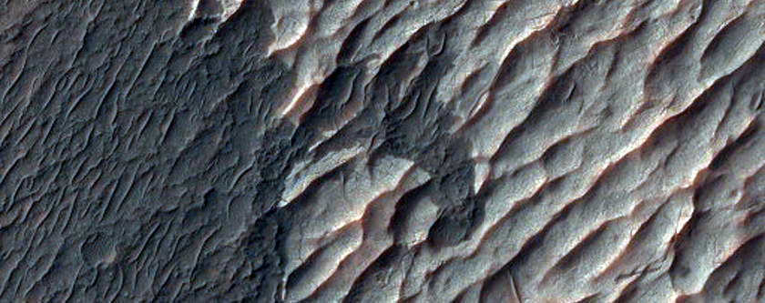
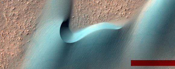
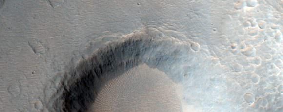
We frequently call the HiRISE camera on board the Mars Reconnaissance Orbiter “our favorite camera” and for good reason. HiRISE, the High Resolution Imaging Science Experiment, is the largest and most powerful camera ever flown on a planetary mission, sending back incredibly beautiful, high-resolution images of Mars. While previous cameras on other Mars orbiters can identify objects about the size of a school bus, HiRISE brings it to human scale, imaging objects as small as 3 feet (1 meter) across.
The HiRISE team has just released more than 1,000 new observations of Mars for the Planetary Data System archive, showing a wide range of gullies, dunes, craters, geological layering and other features on the Red Planet. Take a look at some of the highlights (click on each image for higher resolution versions and more info):
Chloride and Paleo Dunes in Terra Sirenum. Credit: NASA/JPL/University of Arizona.
MRO orbits at about 300 km above the Martian surface. The width of a HiRISE image covers about about 6 km, with a 1.2 km strip of color in the center. The length of the images can be up to 37 km. If you click on each of these images here, or go to the HiRISE website, you can see the full images in all their glory. To fully appreciate the images, you can download the special HiView application, which allows you to see the images in various formats.
Dunes Within Arkhangelsky Crater. Credit: NASA/JPL/University of Arizona
HiRISE has been nicknamed “The People’s Camera“ because the team allows the public to choose specific targets for the camera to image. Check out the HiWISH page here if you’d like a certain spot on Mars imaged.
Crater Near Hydaspis Chaos. Credit: NASA/JPL/University of Arizona.
The lead image (the link to the image on the HiRISE site is here) shows a possible recurring slope lineae (RSL), mysterious dark streaks on slopes that appeared to ebb and flow over time. They darken and appear to flow down steep slopes during warm seasons, and then fade in cooler seasons. One possibility is this is evidence of liquid water present on Mars today. Some scientists said it could be a salty, briny liquid water flowing down the slopes. But a recent analysis says the RSLs show no mineralogical evidence for abundant liquid water or its by-products, and so it might be mechanisms other than the flow of water — such as the freeze and thaw of carbon dioxide frost — as being the major drivers of recent RSLs.
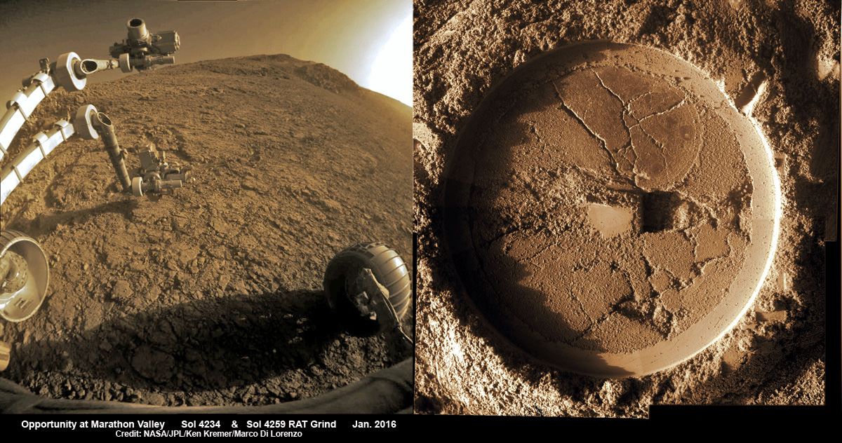
Composite hazcam camera image (left) shows the robotic arm in motion as NASA’s Mars Exploration Rover Opportunity places the tool turret on the target named “Private John Potts” on Sol 4234 to brush away obscuring dust. Rover is actively working on the southern side of “Marathon Valley” which slices through western rim of Endeavour Crater. On Sol 4259 (Jan. 16, 2016), Opportunity completed grinds with the Rock Abrasion Tool (RAT) to exposure rock interior for elemental analysis, as seen in mosaic (right) of four up close images taken by Microscopic Imager (MI). Credit: NASA/JPL/Cornell/Ken Kremer/kenkremer.com/Marco Di Lorenzo
Composite hazcam camera image (left) shows the robotic arm in motion as NASA’s Mars Exploration Rover Opportunity places the tool turret on the target named “Private John Potts” on Sol 4234 to brush away obscuring dust. Rover is actively working on the southern side of “Marathon Valley” which slices through western rim of Endeavour Crater. On Sol 4259 (Jan. 16, 2016), Opportunity completed grinds with the Rock Abrasion Tool (RAT) to exposure rock interior for elemental analysis, as seen in mosaic (right) of four up close images taken by Microscopic Imager (MI). Credit: NASA/JPL/Cornell/Ken Kremer/kenkremer.com/Marco Di Lorenzo
NASA’s world famous Mars Exploration RoverOpportunity continues blazing a daily trail of unprecedented science first’s, still swinging her robotic arm robustly into action at a Martian “Mining Zone” on the 12th anniversary of her hair-raising Red Planet touchdown this week, a top rover scientist told Universe Today.
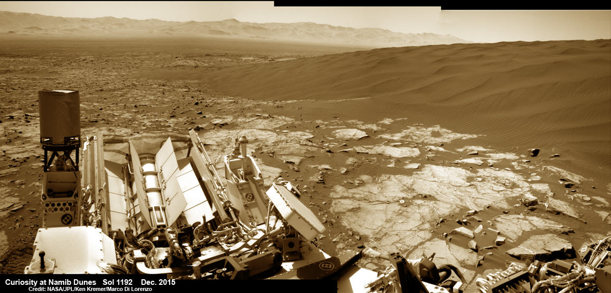
Curiosity explores Namib Dunes at base of Mount Sharp, for first in-place study of an active sand dune anywhere other than Earth. See Gale Crater rim in the distance.This colorized photo mosaic is stitched from navcam camera raw images taken on Sol 1192, Dec. 13, 2015. Credit: NASA/JPL/Ken Kremer/kenkremer.com/Marco Di Lorenzo
Curiosity’s View on Mars Today
Curiosity explores Namib Dunes at base of Mount Sharp, for first in-place study of an active sand dune anywhere other than Earth. See Gale Crater rim in the distance.This colorized photo mosaic is stitched from navcam camera raw images taken on Sol 1192, Dec. 13, 2015. Credit: NASA/JPL/Ken Kremer/kenkremer.com/Marco Di Lorenzo
After many months of painstaking driving, NASA’s Curiosity Mars rover has reached the edge of a massive field of spectacular rippled sand dunes located at the base of Mount Sharp that range up to two stories tall. And she has now begun humanity’s first up-close investigation of currently active sand dunes anywhere beyond Earth.
Artist's conception of Mars, with asteroids nearby. Credit: NASA
Mars represents something of a conundrum for scientists. In many respects, it is significantly different from Earth. It’s cold, it’s dry, there is little atmosphere or precipitation to speak of, and nothing grows there. By our standards, that makes it an incredibly inhospitable place. And yet, in many other respects, it is quite similar to our world.
For instance, Mars’ internal structure is differentiated between a metallic core and a silicate mantle and crust. It also has plenty of water, though the majority of it is concentrated in the polar regions as water ice (and as a permanent layer of permafrost under much of the surface). But perhaps most striking of all, a day on Mars is almost the same as a day here on Earth.
In fact, a day on Mars is roughly 40 minutes longer than a day is here on Earth. Compared to other bodies in our Solar System where a day is either incredibly short (Jupiter’s rotates once on its axis every 9 hours, 55 minutes and 29.69 seconds) or incredibly long (a day on Venus lasts for 116 days and 18 hours), this similarity is quite astounding.
However, there are some things that need to be addressed before we go about declaring just how long a day is on another planet. In fact, there are two ways to determine the length of a day on a celestial body, the sidereal day and the solar day; both of which are used by astronomers for determining the passage on time.
Sidereal vs. Solar:
By definition, a sidereal day on Mars is the length of time that it takes the planet to rotate once on its axis so that stars appear in the same place in the night sky. On Earth, this takes exactly 23 hours, 56 minutes and 4.1 seconds. In comparison, on Mars, a sidereal day lasts 24 hours, 37 minutes, and 22 seconds.
The solar day, by contrast, is the time it takes for the Earth to rotate on its axis so that the Sun appears in the same position in the sky. This position changes slightly each day, but on Earth, a mean solar day works out to being 24 hours long. On Mars, a solar day lasts 24 hours, 39 minutes, and 35 seconds. Rounding that out, we say that a day here on Earth works out to an even 24 hours while on Mars, a day lasts 24 hours and 40 minutes.
Want to know about some other interesting similarities Mars has with Earth? Read on!
Seasonal Changes:
Mars also has a seasonal cycle that is similar to that of Earth’s. This is due in part to the fact that Mars also has a tilted axis, which is inclined 25.19° to its orbital plane (compared to Earth’s axial tilt of approx. 23.44°). It’s also due to Mars orbital eccentricity, which mean that it ranges in distance from 206.7 million to249.2 million kilometers from the Sun.
This change in distance causes significant variations in temperature. While the planet’s average temperature is -46 °C (51 °F), this ranges from a low of -143 °C (-225.4 °F) during the winter at the poles to a high of 35 °C (95 °F) during summer and midday at the equator. This high in temperatures is what allows for liquid water to still flow, albeit intermittently, on the surface of Mars.
It also snows on Mars. In 2008, NASA’s Phoenix Landerfound water ice in the polar regions of the planet. This was an expected finding, but scientists were not prepared to observe snow falling from clouds. The snow, combined with soil chemistry experiments, led scientists to believe that the landing site had a wetter and warmer climate in the past.
The eccentricity in Mars’ orbit is what causes some significant variations in temperature. Credit: NASA
And then in 2012, data obtained by the Mars Reconnaissance Orbiter revealed that carbon-dioxide snowfalls occur in the southern polar region of Mars. For decades, scientists have known that carbon-dioxide ice is a permanent part of Mars’ seasonal cycle and exists in the southern polar caps. But this was the first time that such a phenomena was detected, and it remains the only known example of carbon-dioxide snow falling anywhere in our solar system.
For starters, soil samples and orbital observation have demonstrated conclusively that roughly 3.7 billion years ago, the planet had more water on its surface than is currently in the Atlantic Ocean. Similarly, atmospheric studies conducted on the surface and from space have proven that Mars also had a viable atmosphere at that time, one which was slowly stripped away by solar wind.
Weather Patterns:
Like Earth, Mars can have some pretty extreme weather. In the Red Planet’s case, this takes the form of dust storms that can dominated the surface from time to time. These storms have been known to grow to be thousands of kilometers across, occasionally encircling the entire planet and covering everything in a thick haze of dust. When these storms become that large, they prevent direct observation of the Martian surface.
Case in point: when the Mariner 9 orbiter became the first spacecraft to orbit Mars in 1971, it sent pictures back to Earth of a world consumed in haze. The entire planet was covered by a dust storm so massive that only Olympus Mons, the giant Martian volcano that measures 24 km high, could be seen above the clouds. This storm lasted for a full month, and delayed Mariner 9‘s attempts to photograph the planet in detail.
And then on June 9th, 2001, the Hubble Space Telescope spotted a dust storm in the Hellas Basin on Mars. By July, the storm had died down, but then grew again to become the largest storm in 25 years. So big was the storm that amateur astronomers using small telescopes were able to see it from Earth. And the cloud raised the temperature of the frigid Martian atmosphere by a stunning 30° Celsius.
Therein lies another thing Mars has in common with Earth – global warming! Much like warming trends here on Earth, warming on Mars is caused by the presence of particulate matter in the air that absorbs energy from the Sun and radiates it outward into the atmosphere. causing average temperatures to rise.
These storms tend to occur when Mars is closest to the Sun, and are the result of temperatures rising and triggering changes in the air and soil. As the soil dries, it becomes more easily picked up by air currents, which are caused by pressure changes due to increased heat. The dust storms cause temperatures to rise even further, so you could say Mars has a “greenhouse effect” of its own!
As you have probably concluded from all the facts listed above, Mars can be a harsh and volatile planet. Just knowing the answer to ”how long is a day on Mars?” only provides a small glimpse of what is going on there. At the end of the day (no pun intended!) there is plenty happening on Mars that makes it similar enough to Earth that many people are actually contemplating living there someday. And knowing exactly what sets Mars apart, and what we can work with, will be intrinsic to making that happen!
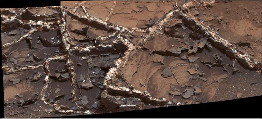
Panoramic view from NASA’s Opportunity rover looking down the floor of Marathon Valley and out to the vast expense of Endeavour Crater. Marathon Valley holds significant deposits of water altered clay minerals. This composite photo mosaic shows the rover’s robotic arm reaching out at left to investigate Martian rocks holding clues to the planets watery past, and robot shadow and wheel tracks visible at right. The mosaic combines a flattened fisheye hazcam image at left with a trio of navcam camera images taken on Sol 4144 (Sept. 20, 2015) and colorized. Credit: NASA/JPL/Cornell/Ken Kremer/kenkremer.com/Marco Di Lorenzo
As NASA’s Opportunity rover approaches the 12th anniversary of landing on Mars, her greatest science discoveries yet are likely within grasp in the coming months since she has successfully entered Marathon Valley from atop a Martian mountain and is now prospecting downhill for outcrops of water altered clay minerals.
The valley is the gateway to alien terrain holding significant caches of the water altered minerals that formed under environmental conditions conducive to support Martian microbial life forms, if they ever existed. But as anyone who’s ever climbed down a steep hill knows, you have to be extra careful not to slip and slide and break something, no matter how beautiful the view is – Because no one can hear you scream on Mars! See the downward looking valley view above.
After a years long Martian mountain climbing and mountain top exploratory trek, Opportunity entered a notch named Marathon Valley from atop a breathtakingly scenic ridge overlook atop the western rim of Endeavour Crater.
Marathon Valley measures about 300 yards or meters long and cuts downhill through the west rim of Endeavour crater from west to east. Endeavour crater spans some 22 kilometers (14 miles) in diameter.
See our photo mosaics illustrating Opportunity’s view around and about Marathon Valley and Endeavour Crater, created by the image processing team of Ken Kremer and Marco Di Lorenzo.
Our mosaic above affords a downward looking view from Marathon Valley on Sol 4144, Sept. 20. It uniquely combines raw images from the hazcam and navcam cameras to gain a wider perspective panoramic view of the steep walled valley, and also shows the rover at work stretching out the robotic arm to potential clay mineral rock targets at left. Opportunity’s shadow and wheel tracks are visible at right.
Mosaic view from Opportunity rover looking along the high walls and down the floor of Marathon Valley with deposits of water altered clay minerals and out to the vast expense of Endeavour Crater. This navcam camera photo mosaic was assembled from images taken on Sol 4159 (Oct. 5, 2015) and colorized. Credit: NASA/JPL/Cornell/Marco Di Lorenzo/Ken Kremer/kenkremer.com
In late July, Opportunity began the decent into the valley from the western edge and started investigating scientifically interesting rock targets by conducting a month’s long “walkabout” survey ahead of the upcoming frigid Martian winter – the seventh since touchdown at Meridiani Planum in January 2004.
The walkabout was done to identify targets of interest for follow up scrutiny in and near the valley floor. Opportunity’s big sister Curiosity conducted a similarly themed “walkabout” at the base of Mount Sharp near her landing site located on the opposite side of the Red Planet.
“The valley is somewhat like a chute directed into the crater floor, which is a long ways below. So it is somewhat scary, but also pretty interesting scenery,” writes Larry Crumpler, a science team member from the New Mexico Museum of Natural History & Science, in a mission update.
“Its named Marathon Valley because the rover traveled one marathon’s distance to reach it,” Prof. Ray Arvidson, the rover Deputy Principal Investigator of Washington University told Universe Today.
The NASA rover exceeded the distance of a marathon on the surface of Mars on March 24, 2015, Sol 3968. Opportunity has now driven over 26.46 miles (42.59 kilometers) over nearly a dozen Earth years.
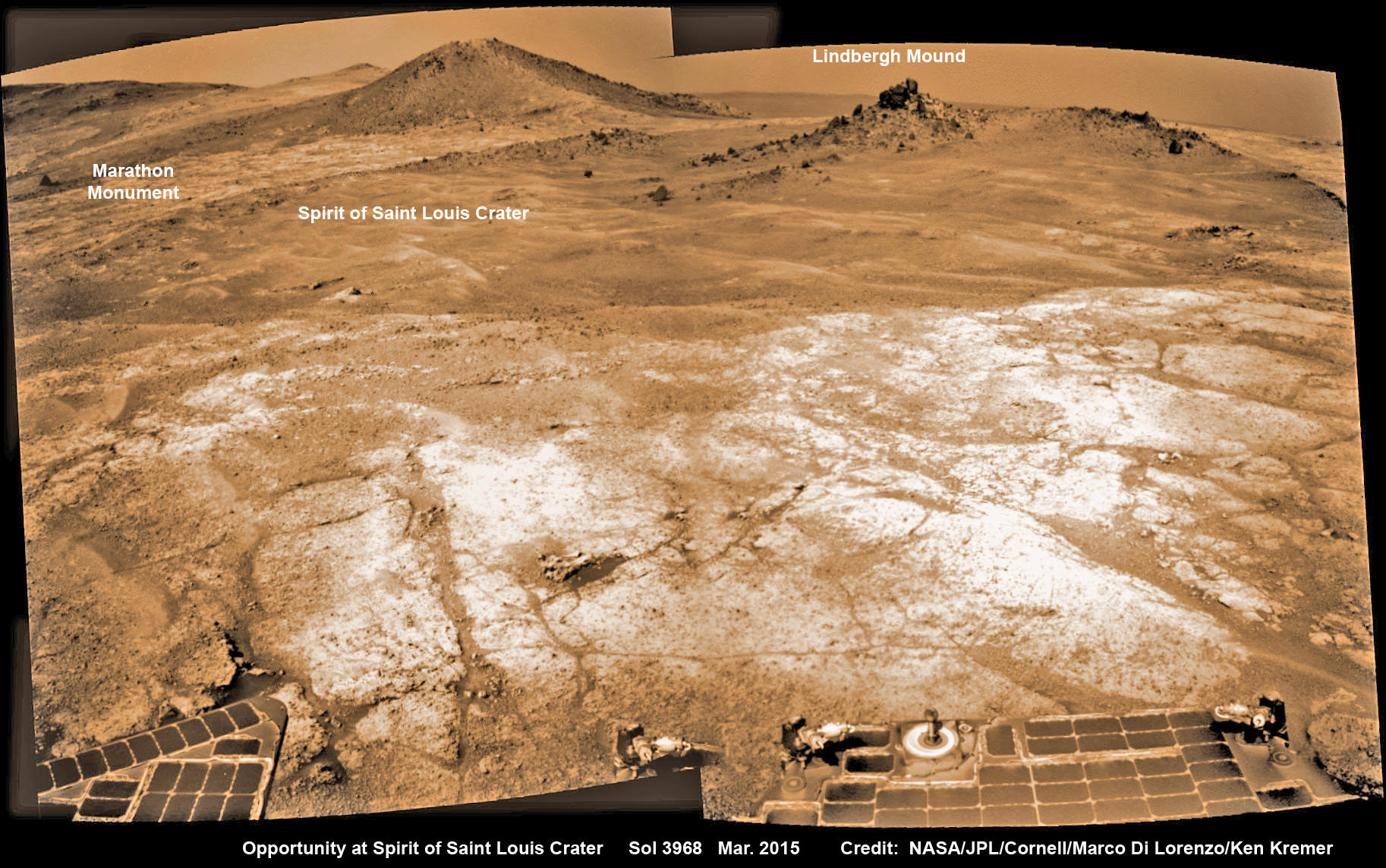
Opportunity’s view (annotated) on the day the NASA rover exceeded the distance of a marathon on the surface of Mars on March 24, 2015, Sol 3968 with features named in honor of Charles Lindbergh’s historic solo flight across the Atlantic Ocean in 1927. Rover stands at Spirit of Saint Louis Crater near mountaintop at Marathon Valley overlook and Martian cliffs at Endeavour crater holding deposits of water altered clay minerals. This navcam camera photo mosaic was assembled from images taken on Sol 3968 (March 24, 2015) and colorized. Credit: NASA/JPL/Cornell/Marco Di Lorenzo/Ken Kremer/kenkremer.com
Now for the first time in history, a human emissary has arrived to conduct an up close inspection of and elucidate clues into this regions potential regarding Martian habitability.
The ancient, weathered slopes around Marathon Valley hold a motherlode of ‘phyllosilicate’ clay minerals, based on data obtained from the extensive Mars orbital measurements gathered by the CRISM spectrometer on NASA’s Mars Reconnaissance Orbiter (MRO) – accomplished earlier at the direction of Arvidson.
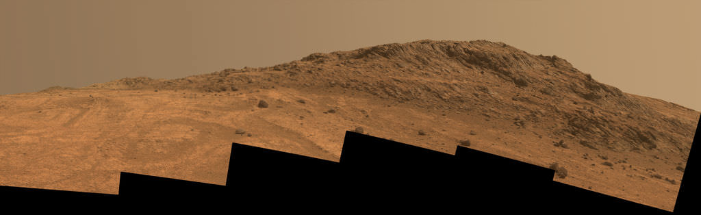
‘Hinners Point’ Above Floor of ‘Marathon Valley’ on Mars. This Martian scene shows contrasting textures and colors of “Hinners Point,” at the northern edge of “Marathon Valley,” and swirling reddish zones on the valley floor to the left. Credit: NASA/JPL-Caltech/Cornell Univ./Arizona State Univ.
Initially the science team was focused on investigating the northern region of the valley while the sun was still higher in the sky and generating more power for research activities from the life giving solar arrays.
“We have detective work to do in Marathon Valley for many months ahead,” said Opportunity Deputy Principal Investigator Ray Arvidson, of Washington University in St. Louis.
But now that the rover is descending into a narrow valley with high walls, the rovers engineering handlers back on Earth have to exercise added caution regarding exactly where they send the Opportunity on her science forays during each sols drive, in order to maintain daily communications.
The high walls to the north and west of the valley ridgeline has already caused several communications blackouts for the “low-elevation Ultra-High-Frequency (UHF) relay passes to the west,” according to the JPL team controlling the rover.
Indeed on two occasions in mid September – coinciding with the days just before and after our Sol 4144 (Sept. 20) photo mosaic view above, “no data were received as the orbiter’s flight path was below the elevation on the valley ridgeline.
On Sept 17 and Sept. 21 “the high ridgeline of the valley obscured the low-elevation pass” and little to no data were received. However the rover did gather imagery and spectroscopic measurements for later transmission.
Now that winter is approaching the rover is moving to the southern side of Marathon Valley to soak up more of the sun’s rays from the sun-facing slope and continue research activities.
“During the Martian late fall and winter seasons Opportunity will conduct its measurements and traverses on the southern side of the valley,” says Arvidson.
“When spring arrives the rover will return to the valley floor for detailed measurements of outcrops that may host the clay minerals.”
The shortest-daylight period of this seventh Martian winter for Opportunity will come in January 2016.
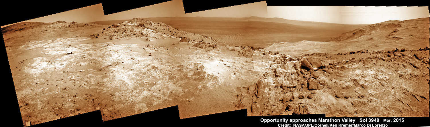
NASA’s Opportunity Rover scans along a spectacular overlook toward Marathon Valley on March 3, 2015, showing flat-faced rocks exhibiting a completely new composition from others examined earlier. Marathon Valley and Martian cliffs on Endeavour crater hold deposits of water altered clay minerals. This navcam camera photo mosaic was assembled from images taken on Sol 3948 (March 3, 2015) and colorized. Credit: NASA/JPL/Cornell/Ken Kremer/kenkremer.com/Marco Di Lorenzo
As of today, Sol 4168, Oct, 15, 2015 Opportunity has taken over 206,300 images and traversed over 26.46 miles (42.59 kilometers).
Stay tuned here for Ken’s continuing Earth and planetary science and human spaceflight news.
Nearly 12 Year Traverse Map for NASA’s Opportunity rover from 2004 to 2015
This map shows the entire path the rover has driven during almost 12 years and more than a marathon runners distance on Mars for over 4163 Sols, or Martian days, since landing inside Eagle Crater on Jan 24, 2004 – to current location at the western rim of Endeavour Crater and descending into Marathon Valley. Rover surpassed Marathon distance on Sol 3968 and marked 11th Martian anniversary on Sol 3911. Opportunity discovered clay minerals at Esperance – indicative of a habitable zone – and is currently searching for more at Marathon Valley. Credit: NASA/JPL/Cornell/ASU/Marco Di Lorenzo/Ken Kremer/kenkremer.com