‘The Martian’ is a Cinematic Triumph – Follow Mark Watney’s Trail across the Real Mars in Photos and Flyover Video

Scene from ‘The Martian’ starring Matt Damon as NASA astronaut Mark Watney contemplating magnificent panoramic vista while stranded alone on Mars. Credits: 20th Century Fox

Scene from ‘The Martian’ starring Matt Damon as NASA astronaut Mark Watney contemplating magnificent panoramic vista while stranded alone on Mars.
Credits: 20th Century Fox
See real Martian maps and flyover video from DLR and NSA below
Story/imagery updated[/caption]

Go now and experience Hollywood’s blockbuster new space epic ‘The Martian’ helmed by world renowned director Ridley Scott and starring Matt Damon as the protagonist, NASA astronaut Mark Watney. And you can follow Watney’s dramatic fictional path across the Red Planet in newly released real photos and a flyover video of the region, from DLR and NASA, as it looks today.

‘The Martian’ is a mesmerizingly enjoyable cinematic triumph for everyone that’s all about science, space exploration and one man’s struggle to survive while left totally isolated on the Red Planet in the face of seemingly insurmountable odds – relying on his wits alone to endure “on a planet where nothing grows” while hoping somehow for a rescue by NASA four years in the future.

The movie combines compelling and plausible storytelling with outstanding special effects that’s clearly delighting huge audiences worldwide with a positive and uplifting view of what could be achieved in the future – if only we really put our minds to it!

Based on the bestselling book by Andy Weir, ‘The Martian’ movie from 20th Century Fox tells the spellbinding story of how NASA astronaut Mark Watney is accidentally stranded on the surface of Mars during the future Ares 3 manned expedition in 2035, after a sudden and unexpectedly fierce dust storm forces the rest of the six person crew – commanded by Jessica Chastain as Commander Lewis – to quickly evacuate after they believe he is dead.
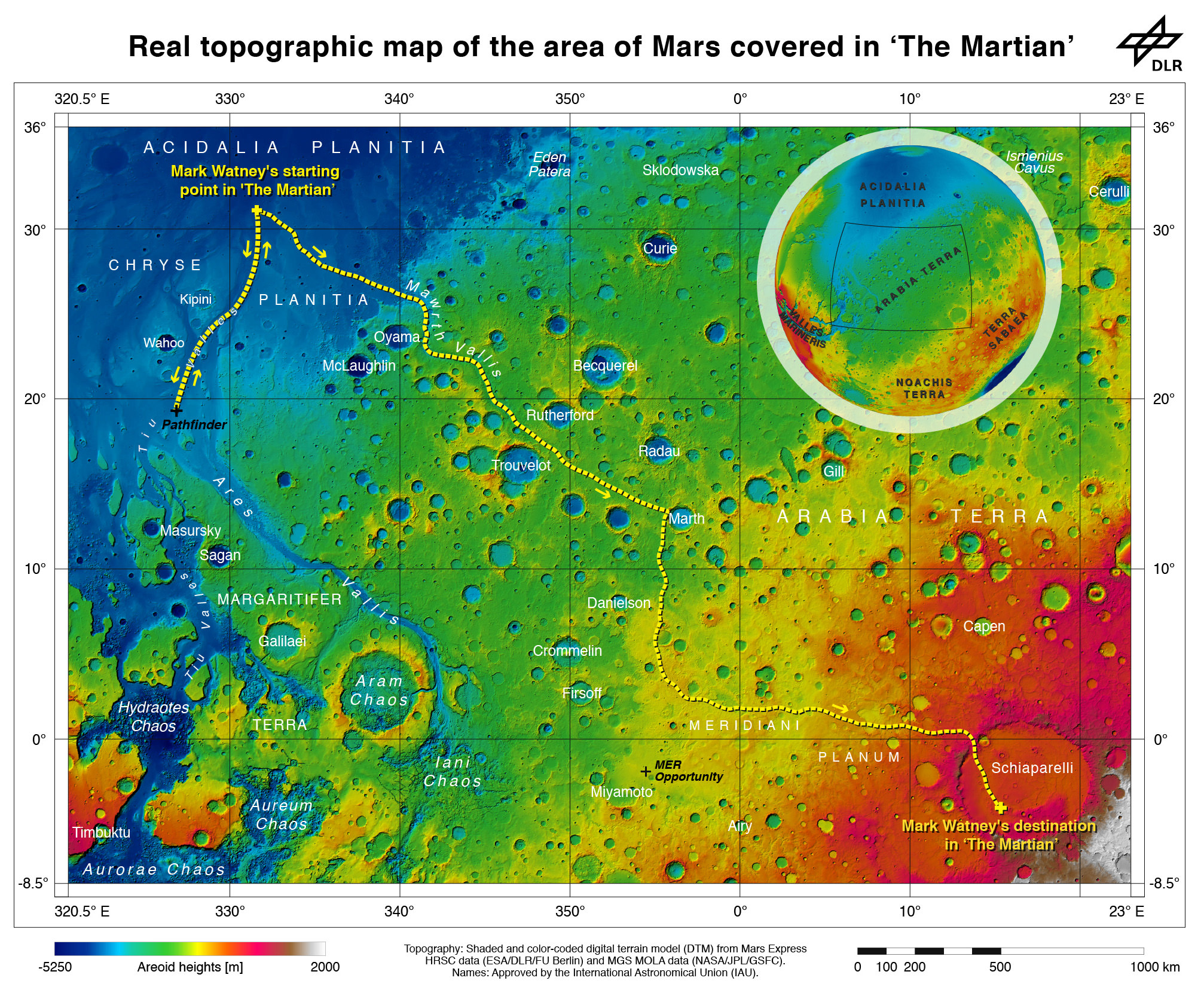
Real topographic map of the area of Mars covered in ‘The Martian.’ Follow the path of Mark Watney’s fictional endeavors from the Ares 3 landing site at Acidalia Planitia to NASA’s real Mars Pathfinder lander at the mouths of Ares Vallis and Tiu Valles and back, and finally to the Ares 4 landing site at  Schiaparelli Crater.  Credit: DLR/ESA
Real topographic map of the area of Mars covered in ‘The Martian.’ Follow the path of Mark Watney’s fictional endeavors from the Ares 3 landing site at Acidalia Planitia to NASA’s real Mars Pathfinder lander at the mouths of Ares Vallis and Tiu Valles and back, and finally to the Ares 4 landing site at Schiaparelli Crater. Credit: DLR/ESA/NASA

Now you can follow the fictional exploits of Mark Watney’s stunningly beautiful trail across the real Mars through a set of newly released maps, imagery and a 3D video created by the DLR, the German Aerospace Agency, and NASA – and based on photos taken by the European Space Agency’s Mars Express orbiter and NASA’s Mars Reconnaissance Orbiter (MRO).

DLR’s stunning 3D overflight video sequence was created from a dataset of 7300 stereo images covering roughly two-and-a-half million square kilometres of precisely mapped Martian landscape captured over the past 12 years by Mars Express High Resolution Stereo Camera (HRSC). The electric score is by Stephan Elgner.

Video Caption: Following the path of The Martian – video generated using images acquired by the Mars Express orbiter. Scientists from German Aerospace Center, DLR– who specialise in producing highly accurate topographical maps of Mars – reconstructed Watney’s route using stereo image data acquired by the High Resolution Stereo Camera on board European Space Agency’s #MarsExpress spacecraft. They then compiled this data into a video that shows the spectacular landscape that the protagonist would see ‘in the future’ on his trek from Ares 3 at Acidalia Planitia/Chryse Planitia to Ares 4 at Schiaparelli Crater. Credit: DLR/ESA

Ridley Scotts ‘The Martian’ takes place mostly on the surface of the Red Planet and is chock full of breathtakingly beautiful panoramic vistas. In the book you can only imagine Mars. In the movie Scott’s talents shine as he immerses you in all the action on the alien world of Mars from the opening scene.

Starting with the landing site for Watney’s Ares 3 mission crew at Acidalia Planitia, the book and movie follows his triumphs and tribulations, failures and successes as he logically solves one challenging problem after another – only to face increasingly daunting and unexpected hurdles as time goes by and supplies run low.

The DLR route map shows a real topographic view of Watney’s initial journey back and forth from the fictional Ares 3 landing site to the actual landing site of NASA’s 1997 Mars Pathfinder lander and Sojourner rover mission at the mouth of Ares Vallis.

People and technology from NASA's Jet Propulsion Laboratory aid fictional astronaut Mark Watney during his epic survival story in "The Martian."  Credits: 20th Century Fox
Mark Watney arrives at the NASA’s 1997 Pathfinder lander to gather communications gear in a scene from “The Martian.” People and technology from NASA’s Jet Propulsion Laboratory aid fictional astronaut Mark Watney during his epic survival story in “The Martian.” Credits: 20th Century Fox

The map continues with Watney’s months-long epic trek to the fictional landing site of Ares 4 Mars Ascent Vehicle (MAV) spacecraft at Schiaparelli Crater, by way of Marth Valles and other Martian landmarks, craters and valleys.

At the request of Andy Weir, the HiRISE camera on NASA’s MRO orbiter took photos of the Martian plain at the Ares 3 landing site in Acidalia Planitia, which is within driving distance from the Pathfinder lander and Sojourner rover in the book and movie.
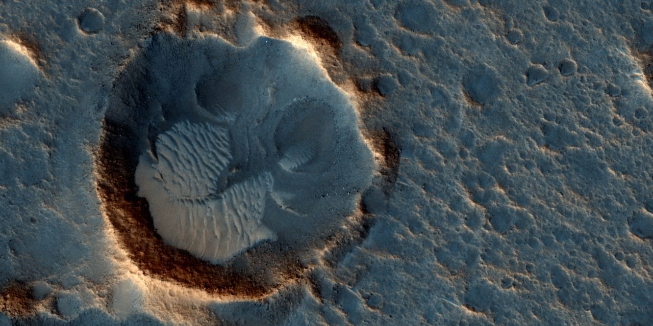
This May 2015 image from the HiRISE camera on NASA's Mars Reconnaissance Orbiter shows a location on Mars associated with the best-selling novel and Hollywood movie, "The Martian." It is in a region called Acidalia Planitia, at the landing site for the science-fiction tale's Ares 3 mission.  For the story's central character, Acidalia Planitia is within driving distance from where NASA's Mars Pathfinder, with its Sojourner rover, landed in 1997. Credits: NASA/JPL-Caltech/Univ. of Arizona
This May 2015 image from the HiRISE camera on NASA’s Mars Reconnaissance Orbiter shows a location on Mars associated with the best-selling novel and Hollywood movie, “The Martian.” It is in a region called Acidalia Planitia, at the landing site for the science-fiction tale’s Ares 3 mission. For the story’s central character, Acidalia Planitia is within driving distance from where NASA’s Mars Pathfinder, with its Sojourner rover, landed in 1997. Credits: NASA/JPL-Caltech/Univ. of Arizona

The Martian is all about how Watney uses his botany, chemistry and engineering skills to “Science the sh** out of it” to grow food and survive until the hoped for NASA rescue.

Learning how to live off the land will be a key hurdle towards enabling NASA’s real strategy for long term space voyages on a ‘Journey to Mars’ and back.

‘The Martian’ is a must see movie that broadly appeals to space enthusiasts and general audiences alike who can easily identify with Watney’s ingenuity and will to live.

Since its worldwide premiere on Oct. 2, ‘The Martian’ has skyrocketed to the top of the US box office for the second weekend in a row, hauling in some $37.3 million. The total domestic box office receipts now top $108 million and rockets to over $228 million worldwide in the first 10 days alone.

I absolutely loved ‘The Martian’ when I first saw the movie on opening weekend. And enjoyed it even more the second time, when I could pick up a few details I missed the first time around.

Matt Damon stars as NASA astronaut Mark Watney in ‘The Martian.' Credit: 20th Century Fox
Matt Damon stars as NASA astronaut Mark Watney in ‘The Martian.’ Credit: 20th Century Fox

The movie begins as the crew evacuates after they believe Watney was killed by the dust storm. Watney actually survived the storm but lost contact with NASA. The film recounts his ingenious years long struggle to survive, figure out how to tell NASA he is alive and send a rescue crew before he starves to death on a planet where nothing grows. Watney’s predicament is a survival lesson to all including NASA.

‘The Martian’ was written by Andy Weir in 2010 and the film could well break the October movie box office record currently held by ‘Gravity.’

The movie closely follows the book, which I highly recommend you read at some point.

By necessity, the 2 hour 20 minute movie cannot capture every event in the book. So there is an abbreviated sense of Watney’s detailed science to survive and lengthy overland trips.

All the heroics and difficulties in traveling to Pathfinder and back and getting communications started, as well as the final month’s long journey to Schiaparelli crater are significantly condensed, but captured in spirit.

The Martian is brilliant and intelligent and rivals Stanley Kubrik’s space epic ‘2001: A Space Odyssey’ as one of the top movies about humanities space exploration quest.

The one big science inaccuracy takes place right at the start with the violent Martian dust storm.

On Mars the atmosphere is so thin that the winds would not be anywhere near as powerful or destructive as portrayed. This is acknowledged by Weir and done for dramatic license. We can look past that since the remainder of the tale portrays a rather realistic architectural path to Mars and vision of how scientists and engineers think. Plus the dust storms can in fact kick up tremendous amounts of particles that significantly block sunlight from impinging on solar energy generating panels.

Personally I can’t wait for the ‘Directors Cut’ with an added 30 to 60 minutes of scenes that were clearly filmed – but not included in the original theatrical release.

THE MARTIAN features a star studded cast that includes Matt Damon, Jessica Chastain, Kristen Wiig, Kate Mara, Michael Pena, Jeff Daniels, Chiwetel Ejiofor, and Donald Glover.

“NASA has endorsed “The Martian’” Jim Green, NASA’s Director of Planetary Sciences, told Universe Today. Green served as technical consultant on the film.

At NASA’s Kennedy Space Center in Florida agency scientists, astronauts actors from the 20th Century Fox Entertainment film "The Martian" met the media. Participants included, from the left, Center Director Bob Cabana, NASA's Planetary Science Division Director Jim Green, Ph.D., actress Mackenzie Davis, who portrays Mindy Park in the movie, retired NASA astronaut Nicole Stott and actor Chiwetel Ejiofor, who portrays Vincent Kapoor in "The Martian." Credit: Julian Leek
At NASA’s Kennedy Space Center in Florida agency scientists, astronauts actors from the 20th Century Fox Entertainment film “The Martian” met the media. Participants included, from the left, Center Director Bob Cabana, NASA’s Planetary Science Division Director Jim Green, Ph.D., actress Mackenzie Davis, who portrays Mindy Park in the movie, retired NASA astronaut Nicole Stott and actor Chiwetel Ejiofor, who portrays Vincent Kapoor in “The Martian.” Credit: Julian Leek

The DLR film was created by a team led by Ralf Jaumann from the DLR Institute of Planetary Research, Principal Investigator for HRSC. He believes that producing the overflight video was not just a gimmick for a science fiction film:

“Mars generates immense fascination, and our curiosity continues to grow! Many people are interested in our research, and young people in particular want to know what it is really like up there, and how realistic the idea that one day people will leave their footprints on the surface of Mars truly is. The data acquired by HRSC shows Mars with a clarity and detail unmatched by any other experiment. Only images acquired directly on the surface, for instance by rovers like Curiosity, are even closer to reality, but they can only show a small part of the planet. Thanks to this animation, we have even noticed a few new details that we had not seen in a larger spatial context. That is why we made the film – it helps everyone see what it would be like for Watney to travel through these areas… the clouds were the only creative touches we added, because, fortunately, they do not appear in the HRSC data,” according to a DLR statement.

Here’s the second official trailer for The Martian:

As a scientist and just plain Earthling, my most fervent hope is that ‘The Martian’ will inspire our young people to get interested in all fields of science, math and engineering and get motivated to become the next generation of explorers – here on Earth and beyond to the High Frontier to benefit all Mankind.

Stay tuned here for Ken’s continuing Earth and planetary science and human spaceflight news.

Ken Kremer

Movie poster for The Martian
The Martian. Image credit: 20th Century Fox

Route map in original German (Deutsch):

21962932715_702f79a908_o

NASA Discovers Salty Liquid Water Flows Intermittently on Mars Today, Bolstering Chance for Life

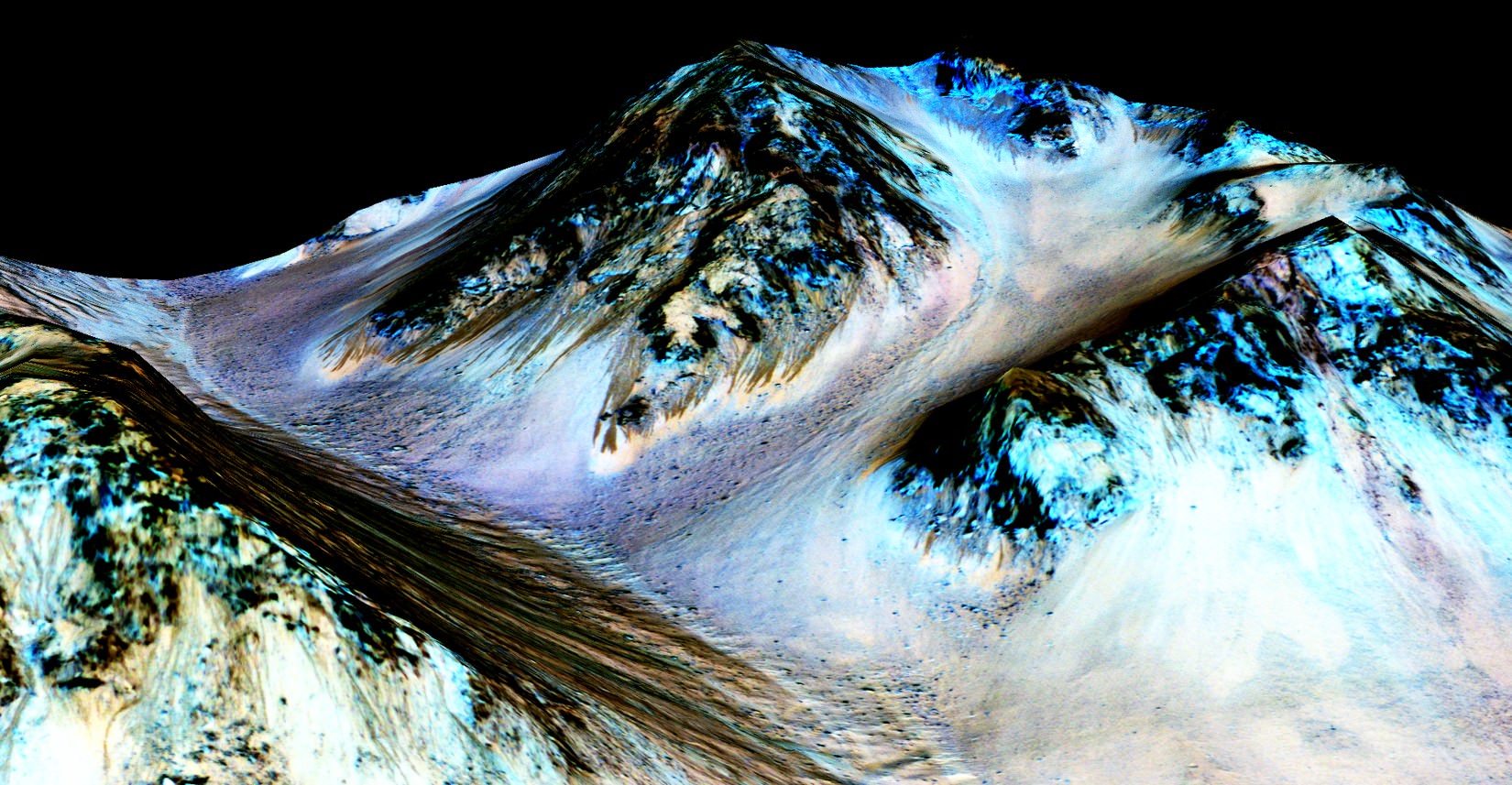
These dark, narrow, 100 meter-long streaks called recurring slope lineae flowing downhill on Mars are inferred to have been formed by contemporary flowing water. However, a new study by planetary scientists indicates that these may actually be the result of dry flows. Credits: NASA/JPL/University of Arizona

These dark, narrow, 100 meter-long streaks called recurring slope lineae flowing downhill on Mars are inferred to have been formed by contemporary flowing water. Recently, planetary scientists detected hydrated salts on these slopes at Hale crater, corroborating their original hypothesis that the streaks are indeed formed by liquid water. The blue color seen upslope of the dark streaks are thought not to be related to their formation, but instead are from the presence of the mineral pyroxene.

The image is produced by draping an orthorectified Infrared-Red-Blue/Green(IRB)) false color image on a Digital Terrain Model (DTM). This model was produced by researchers at the University of Arizona, much like the High Resolution Imaging Science Experiment (University of Arizona). The vertical exaggeration is 1.5.

NASA and Mars planetary scientists announced today (Sept. 28) that salty “liquid water flows intermittently” across multiple spots on the surface of today’s Mars – trumpeting a major scientific discovery with far reaching implications regarding the search for life beyond Earth and bolstering the chances for the possible existence of present day Martian microbes.

Utilizing spectroscopic measurements and imaging gathered by NASA’s Mars Reconnaissance Orbiter (MRO), researchers found the first strong evidence confirming that briny water flows on the Red Planet today along dark streaks moving downhill on crater slopes and mountain sides, during warmer seasons.

“Mars is not the dry, arid planet that we thought of in the past. Today we announce that under certain circumstances, liquid water has been found on Mars,” said Jim Green, NASA Planetary Science Director at NASA Headquarters, at a media briefing held today, Sept 28.

“When you look at Earth, water is an essential ingredient. Everywhere we go where there’s liquid water, whether its deep in the Earth or in the arid regions, we find life. This is tremendously exciting.”

“We haven’t been able to answer the question – does life exist beyond Earth? But following the water is a critical element of that. We now have great opportunities to be in the right locations on Mars to thoroughly investigate that,” Green elaborated.

“Water! Strong evidence that liquid water flows on present-day Mars,” NASA officials tweeted about the discovery.

The evidence comes in the form of the detection of mysterious dark streaks, as long as 100 meters, showing signatures of hydrated salt minerals periodically flowing in liquid water down steep slopes on the Red Planet that “appear to ebb and flow over time.”

The source of the water is likely from the shallow subsurface or possibly absorbed from the atmosphere.

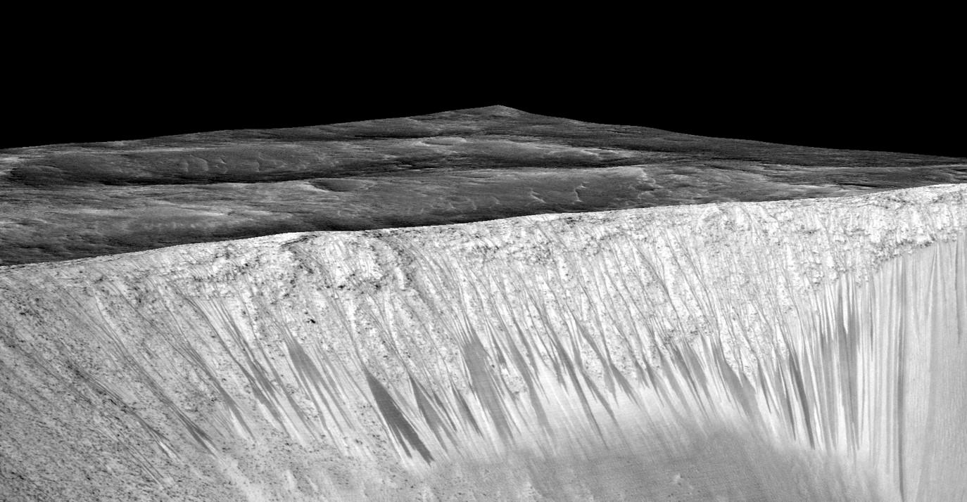
Dark narrow streaks called recurring slope lineae emanating out of the walls of Garni crater on Mars. The dark streaks here are up to few hundred meters in length. They are hypothesized to be formed by flow of briny liquid water on Mars. The image is produced by draping an orthorectified (RED) image (ESP_031059_1685) on a Digital Terrain Model (DTM) of the same site produced by High Resolution Imaging Science Experiment (University of Arizona). Vertical exaggeration is 1.5.    Credits: NASA/JPL/University of Arizona
Dark narrow streaks called recurring slope lineae emanating out of the walls of Garni crater on Mars. The dark streaks here are up to few hundred meters in length. They are hypothesized to be formed by flow of briny liquid water on Mars. The image is produced by draping an orthorectified (RED) image (ESP_031059_1685) on a Digital Terrain Model (DTM) of the same site produced by High Resolution Imaging Science Experiment (University of Arizona). Vertical exaggeration is 1.5. Credits: NASA/JPL/University of Arizona

Water is a key prerequisite for the formation and evolution of life as we know it. So the new finding significantly bolsters the chances that present day extant life could exist on the Red Planet.

“Our quest on Mars has been to ‘follow the water,’ in our search for life in the universe, and now we have convincing science that validates what we’ve long suspected,” said John Grunsfeld, astronaut and associate administrator of NASA’s Science Mission Directorate in Washington.

“This is a significant development, as it appears to confirm that water — albeit briny — is flowing today on the surface of Mars.”

“This increases the chance that life could exist on Mars today,” noted Grunsfeld.

The data were gathered by and the conclusions are based on using two scientific instruments – the high resolution imaging spectrometer on MRO known as High Resolution Imaging Science Experiment (HiRISE), as well as MRO’s mineral mapping Compact Reconnaissance Imaging Spectrometer for Mars (CRISM).

The mysterious dark streaks of downhill flows are known as recurring slope lineae (RSL).

They were first detected in 2010 at dozens of sites on the sun facing slopes of deep craters by Lujendra Ojha, then a University of Arizona undergraduate student.

The new finding is highly significant because until today’s announcement, there was no strong evidence that liquid water could actually exist on the Martian surface because the atmospheric pressure was thought to be far too low – its less than one percent of Earth’s.

The flow of water is occasional and not permanent, seasonally variable and dependent on having just the right mix of atmospheric, temperature and surface conditions with salt deposits on Mars.

Portions of Mars were covered with an ocean of water billions of years ago when the planet was far warmer and more hospitable to life. But it underwent a dramatic climate change some 3 billion years ago and lost most of that water.

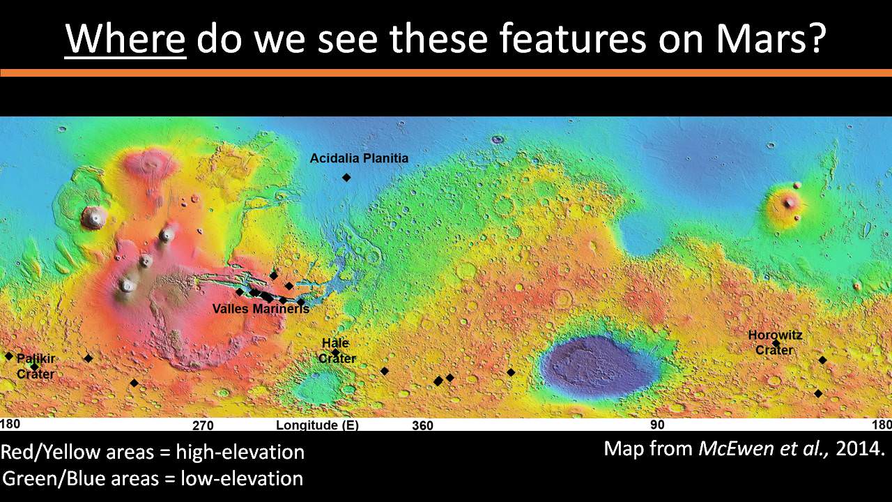
The RSL with flowing water appear in at least three different locations on Mars – including Hale crater, Horowitz crater and Palikir crater – when temperatures are above minus 10 degrees Fahrenheit (minus 23 Celsius). They appear during warm seasons, fade in cooler seasons and disappear during colder times.

Pure surface water ice would simply sublimate and evaporate away as the temperature rises. Mixing in surface salts lowers the melting point of ice, thereby allowing the water to potentially liquefy on Mars surface for a certain period of time rather than sublimating rapidly away.

“These are dark streaks that form in late spring, grow through the summer and then disappear in the fall,” said Michael Meyer lead scientist for the Mars Exploration Program at NASA Headquarters, at the media briefing.

Years of painstaking effort and laboratory work was required to verify and corroborate the finding of flowing liquid water.

“It took multiple spacecraft over several years to solve this mystery, and now we know there is liquid water on the surface of this cold, desert planet,” said Meyer. “It seems that the more we study Mars, the more we learn how life could be supported and where there are resources to support life in the future.”

The dark, narrow streaks flowing downhill on Mars at sites such as this portion of Horowitz Crater are inferred to be formed by seasonal flow of water on modern-day Mars. The streaks are roughly the length of a football field. These dark features on the slopes are called "recurring slope lineae" or RSL. The imaging and topographical information in this processed view come from the High Resolution Imaging Science Experiment (HiRISE) camera on NASA's Mars Reconnaissance Orbiter.   Credit: NASA/JPL-Caltech/Univ. of Arizona
The dark, narrow streaks flowing downhill on Mars at sites such as this portion of Horowitz Crater are inferred to be formed by seasonal flow of water on modern-day Mars. The streaks are roughly the length of a football field. These dark features on the slopes are called “recurring slope lineae” or RSL. The imaging and topographical information in this processed view come from the High Resolution Imaging Science Experiment (HiRISE) camera on NASA’s Mars Reconnaissance Orbiter. Credit: NASA/JPL-Caltech/Univ. of Arizona

Along with the media announcement, the researchers published their findings today in a refereed scientific paper in the Sept. 28 issue of Nature Geoscience.

“We found the hydrated salts only when the seasonal features were widest, which suggests that either the dark streaks themselves or a process that forms them is the source of the hydration. In either case, the detection of hydrated salts on these slopes means that water plays a vital role in the formation of these streaks,” said Lujendra Ojha, now at the Georgia Institute of Technology (Georgia Tech) in Atlanta, and lead author of the Sept. 28 publication in Nature Geoscience.

The scientists “interpret the spectral signatures as caused by hydrated minerals called perchlorates.”

Ojha said the chemical signatures from CRISM were most consistent with the detection of mixtures of magnesium perchlorate, magnesium chlorate and sodium perchlorate, based on lab experiments.

“Some perchlorates have been shown to keep liquids from freezing even when conditions are as cold as minus 94 degrees Fahrenheit (minus 70 Celsius).”

Perchlorates have previously been detected in Martian soil by two of NASA’s surface missions – the Phoenix lander and the Curiosity rover. There is also some evidence that NASA’s Viking missions in the 1970s measured signatures of these salts.

On Earth concentration of perchlorates are found in deserts.

This also marks the first time perchlorates have been identified from Mars orbit.

Locations of RSL features on Mars

NASA’s overriding agency wide goal is to send humans on a ‘Journey to Mars’ in the 2030s.

So NASA astronaut Mark Kelly exclaimed that he was also super excited about the findings, from his perch serving as Commander aboard the International Space Station (ISS), where he is a member of the first ever “1 Year ISS Mission Crew” aimed at learning how the human body will adapt to the long term missions required to send astronauts to Mars and back.

“One reason why NASA’s discovery of liquid water on #Mars is so exciting: we know anywhere there’s water on Earth, there’s some form of life,” Kelly tweeted today from on board the ISS, upon hearing today’s news.

The discovery of liquid water on Mars could also be a boon to future astronauts who could use it as a natural resource to ‘live off the land’ for sustenance and to make rocket fuel.

“If going to Mars on my Year In Space, I’d arrive soon to find water! H20 > rocket fuel, which means I could find my way back home too!,” Kelly wrote on his Facebook page.

“When most people talk about water on Mars, they’re usually talking about ancient water or frozen water,” Ojha explained.

“Now we know there’s more to the story. This is the first spectral detection that unambiguously supports our liquid water-formation hypotheses for RSL.”

Stay tuned here for Ken’s continuing Earth and planetary science and human spaceflight news.

Ken Kremer

Do You See a Mountain or a Crater in This Picture?

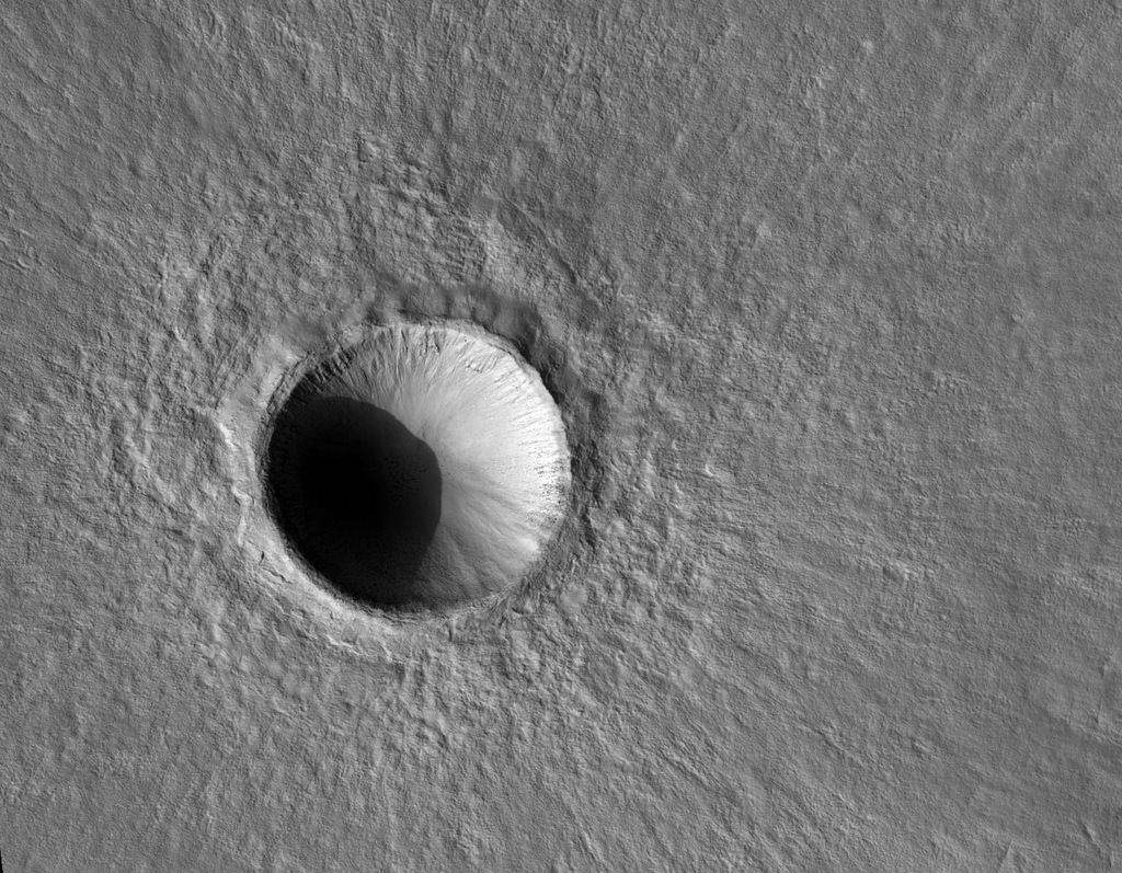
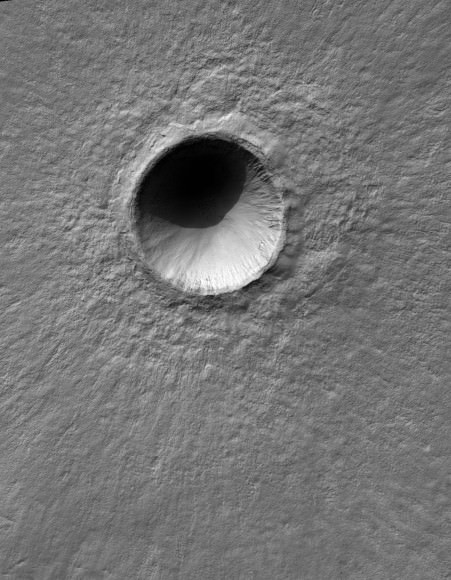
A 'new' fresh 1-km wide crater on Mars, captured by the HiRISE camera on the Mar Reconnaissance Orbiter. Or does it look like a mountain to you? Credit: NASA/JPL/University of Arizona.

Yesterday, we posted an image taken by the HiRISE camera on the Mars Reconnaissance Orbiter (MRO) of an unusual crater formed by a triple-asteroid. We noticed some comments on the article and on social media of people who said, “hey, that looks like a mountain, not a crater!”

Thanks to our brains, this is a common illusion! Depending on the angle of the Sun when the picture was taken, images of craters taken from overhead (i.e. from orbit) may appear to be a mountain. Here on Earth, we’re used to seeing sunlight coming from overhead, and our brain interprets what we see with the assumption that the sunlight *must* always come from above. Satellite photos of terrain, however usually only show shadows when the light source is nearly horizontal with the surface.

There’s an easy fix for this illusion: flip the image over so it appears the sunlight is coming from above. We’ve done that for you, below:

The same 1-km fresh crater on Mars, but with the image upside down. Credit: NASA/JPL/University of Arizona.

Dr. Richard Barrans from Newman University in Kansas explains this crater/mountain illusion:

When a crater is illuminated from above, the shadow inside the crater is near the top and the bright part is near the bottom. A mountain shows exactly the opposite lighting pattern: bright at the top and shadowed at the bottom. This is because the part of the crater or mountain that is most perpendicular to the incoming light reflects it the best. Anyway, your brain interprets pictures under the assumption that the light is from the top of the scene. So if a picture shows an object that is bright at the top and dark at the bottom, it interprets it as a mound lit from above, not as a crater lit from below.

We do know that any photo of anything that is concave or convex will flip in its appearance if the photo is turned upside down. Take a look at any of these crater images from HiRISE, and you’ll likely be deceived on most of them! (remember, they are ALL craters!)

And here’s the image from yesterday:

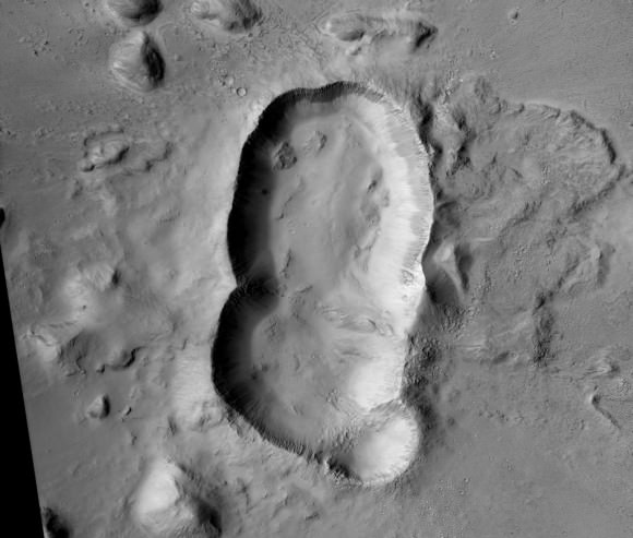
A triple crater in Elysium Planitia on Mars. Credit: NASA/JPL/University of Arizona.

You can now amaze your friends. You’re welcome.

Amazing Impact Crater Where a Triple Asteroid Smashed into Mars

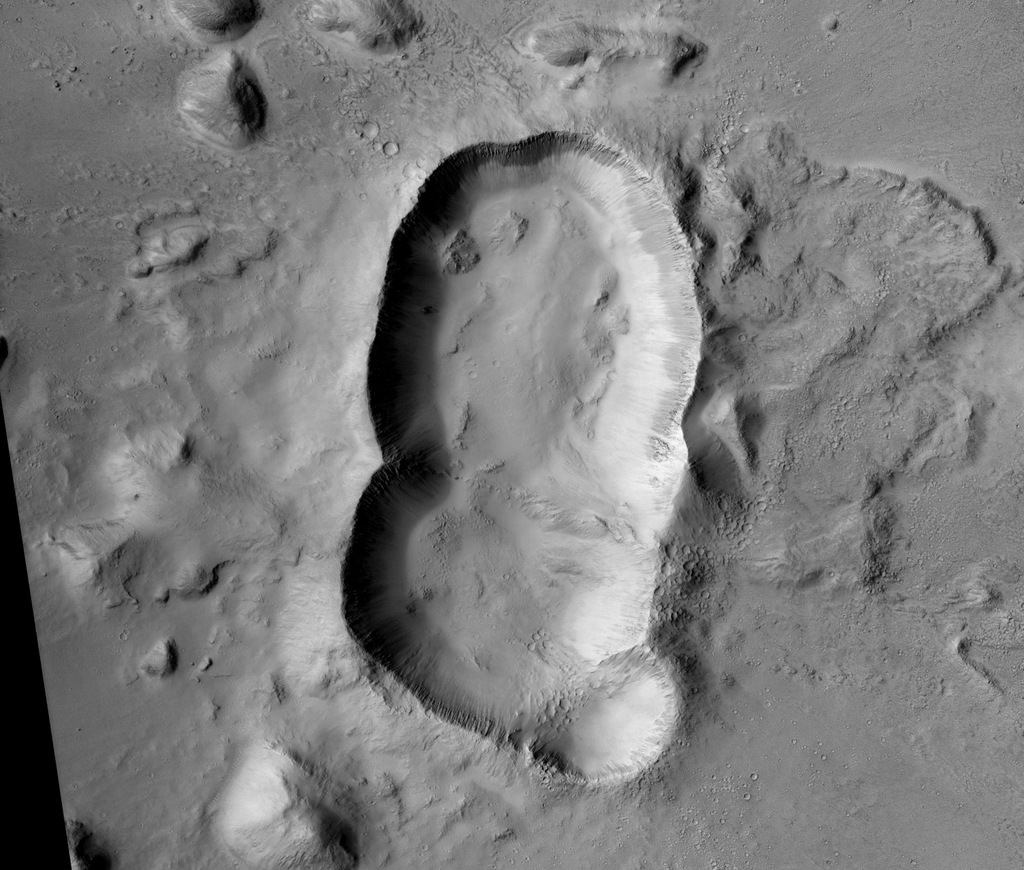
A triple crater in Elysium Planitia on Mars. Credit: NASA/JPL/University of Arizona.

At first glance, you many not guess that this feature on Mars is an impact crater. The reason it looks so unusual is that it likely is a triple impact crater, formed when three asteroids struck all at once in the Elysium Planitia region.

Why do planetary scientists think the three craters did not form independently at different times?

“The ejecta blanket appears to be uniform around the triple-crater showing no signs of burial or overlapping ejecta from overprinting craters,” write scientists Eric Pilles, Livio Tornabene, Ryan Hopkins, and Kayle Hansen on the HiRISE website. “The crater rims are significantly stunted where the craters overlap.”

This oblong-shaped crater could have been created from a triple asteroid, or it could have been a binary asteroid, and one broke apart, creating the three overlapping craters. The team says the two larger craters must have been produced by asteroids of approximately the same size, probably on the order of a few hundred meters across.

“The northern crater might have been created by a smaller asteroid, which was orbiting the larger binary pair, or when one of the binary asteroids broke up upon entering the atmosphere,” the team explained. “The shape of the triple-crater is oblong, suggesting an oblique impact; therefore, another alternative would be that the asteroid split upon impact and ricocheted across the surface, creating additional craters.”

Studying craters on Mars — and there are lots of them, thanks to Mars’ sparse atmosphere — can help estimate the ages of different terrains, as well as revealing materials such as ice or minerals that get exposed from the impact.

HiRISE is the amazing camera on board the Mars Reconnaissance Orbiter.

Martian Permafrost And Dust-Sculpted Surface Captured By NASA Spacecraft

Frost deposits in Louth Crater appears to remain through the year, as found in Mars Reconnaissance Orbiter HiRISE photos of the region. Credit: NASA/JPL/University of Arizona

Mars was once thought to be a fairly unchanging planet, similar to the Moon. But now we know it is a planet that was shaped by water and other forces in the past — and that these forces still come into play today.

Above is a picture of permafrost deposits just discovered in Louth Crater. This find comes from NASA’s Mars Reconnaissance Orbiter’s High Resolution Imaging Science Experiment (HiRISE) and you can see some of its latest water- and dust- shaped environments imaged below.

“A still-unexplained feature of this crater is the diffuse dark smudges visible on the crater floor,” read an update on the University of Arizona HiRISE website explaining this image. “These resemble ‘defrosting spots’ which are visible on carbon dioxide ice in the early spring, but they occur on frost-free areas and survive throughout the summer.”

The frost was caught in a HiRISE image early in the summer, and it persisted as controllers watched it through the summer — indicating that it is permanent. Its size did diminish somewhat, however. Scientists are pretty sure that this is water ice, as carbon dioxide can’t survive the summer.

See more new HiRISE photos below.

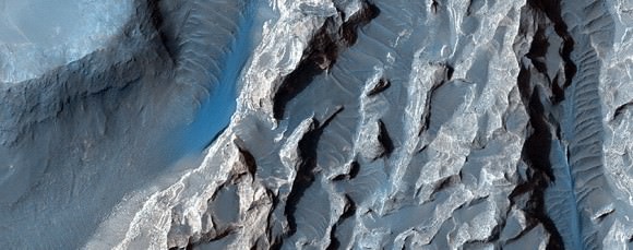
A close-up of "chaotic terrain" in Valles Marineris imaged by the Mars Reconnaissance Orbiter's HiRISE camera. Wind or fluid may have further shaped this region, which could be related to possible signs of an ancient lake found in other regions of Valles Marineris. Credit: NASA/JPL/University of Arizona
A close-up of “chaotic terrain” in Valles Marineris imaged by the Mars Reconnaissance Orbiter’s HiRISE camera. Wind or fluid may have further shaped this region, which could be related to possible signs of an ancient lake found in other regions of Valles Marineris. Credit: NASA/JPL/University of Arizona
A section of the vast Valles Marineris ravine called Melas Chasma, a spot where sulfates (minerals formed in water) have been found before. The image shows layers of deposits that were formed before and after the formation of VAlles Marineris. Credit: NASA/JPL/University of Arizona
A section of the vast Valles Marineris ravine called Melas Chasma, a spot where sulfates (minerals formed in water) have been found before. The image shows layers of deposits that were formed before and after the formation of Valles Marineris. Credit: NASA/JPL/University of Arizona
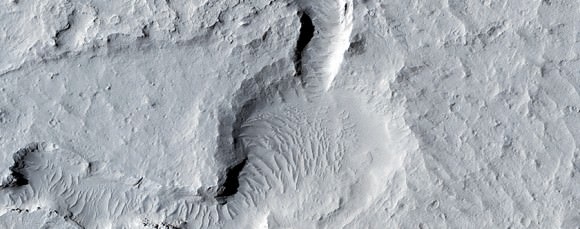
A section of Eastern Elysium Planitia imaged by the Mars Reconnaissance Orbiter's HiRISE camera showing a possible old lava field near dust avalanches stirred up more recently. Credit: NASA/JPL/University of Arizona
A section of Eastern Elysium Planitia imaged by the Mars Reconnaissance Orbiter’s HiRISE camera showing a possible old lava field near dust avalanches stirred up more recently. Credit: NASA/JPL/University of Arizona

MAVEN Mars Orbiter Ideally Poised to Uniquely Map Comet Siding Spring Composition – Exclusive Interview with Principal Investigator Bruce Jakosky

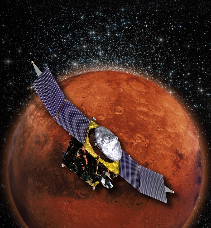
MAVEN is NASA’s next Mars Orbiter and will investigate how the planet lost most of its atmosphere and water over time. Credit: NASA

MAVEN to conduct up close observations of Comet Siding Spring during Oct. 2014
MAVEN is NASA’s next Mars Orbiter and will investigate how the planet lost most of its atmosphere and water over time. Credit: NASA
Story updated[/caption]

NASA’s MAVEN Mars Orbiter is “ideally” instrumented to uniquely “map the composition of Comet Siding Spring” in great detail when it streaks past the Red Planet during an extremely close flyby on Oct. 19, 2014 – thereby providing a totally “unexpected science opportunity … and a before and after look at Mars atmosphere,” Prof. Bruce Jakosky, MAVEN’s Principal Investigator of CU-Boulder, CO, told Universe Today in an exclusive interview.

The probes state-of-the-art ultraviolet spectrograph will be the key instrument making the one-of-a-kind compositional observations of this Oort cloud comet making its first passage through the inner solar system on its millions year orbital journey.

“MAVEN’s Imaging Ultraviolet Spectrograph (IUVS) is the ideal way to observe the comet coma and tail,” Jakosky explained.

“The IUVS can do spectroscopy that will allow derivation of compositional information.”

“It will do imaging of the entire coma and tail, allowing mapping of composition.”

Comet: Siding Spring. The images above show -- before and after filtering -- comet C/2013 A1, also known as Siding Spring, as captured by Wide Field Camera 3 on NASA's Hubble Space Telescope.  Image Credit: NASA, ESA, and J.-Y. Li (Planetary Science Institute)
Comet: Siding Spring
The images above show — before and after filtering — comet C/2013 A1, also known as Siding Spring, as captured by Wide Field Camera 3 on NASA’s Hubble Space Telescope. Image Credit: NASA, ESA, and J.-Y. Li (Planetary Science Institute)

Moreover the UV spectrometer is the only one of its kind amongst NASA’s trio of Martian orbiters making its investigations completely unique.

“IUVS is the only ultraviolet spectrometer that will be observing the comet close up, and that gives the detailed compositional information,” Jakosky elaborated

And MAVEN, or the Mars Atmosphere and Volatile Evolution, is arriving just in the nick of time to fortuitously capture this fantastically rich data set of a pristine remnant from the solar system’s formation.

The spacecraft reaches Mars in less than 15 days. It will rendezvous with the Red Planet on Sept. 21 after a 10 month interplanetary journey from Earth.

Furthermore, since MAVEN’s purpose is the first ever detailed study of Mars upper atmosphere, it will get a before and after look at atmospheric changes.

“We’ll take advantage of this unexpected science opportunity to make observations both of the comet and of the Mars upper atmosphere before and after the comet passage – to look for any changes,” Jakosky stated.

How do MAVEN’s observations compare to NASA’s other orbiters Mars Odyssey (MO) and Mars Reconnaissance Orbiter (MRO), I asked?

“The data from the other orbiters will be complementary to the data from IUVS.”

“Visible light imaging from the other orbiters provides data on the structure of dust in the coma and tail. And infrared imaging provides information on the dust size distribution.”

IUVS is one of MAVENS’s nine science sensors in three instrument suites targeted to study why and exactly when did Mars undergo the radical climatic transformation.

How long will MAVEN make observations of Comet C/2013 A1 Siding Spring?

“We’ll be using IUVS to look at the comet itself, about 2 days before comet nucleus closest approach.”

“In addition, for about two days before and two days after nucleus closest approach, we’ll be using one of our “canned” sequences to observe the upper atmosphere and solar-wind interactions.”

“This will give us a detailed look at the upper atmosphere both before and after the comet, allowing us to look for differences.”

Describe the risk that Comet Siding Spring poses to MAVEN, and the timing?

“We have the encounter with Comet Siding Spring about 2/3 of the way through the commissioning phase we call transition.”

“We think that the risk to the spacecraft from comet dust is minimal, but we’ll be taking steps to reduce the risk even further so that we can move on toward our science mission.”

“Throughout this entire period, though, spacecraft and instrument health and safety come first.”

This graphic depicts the orbit of comet C/2013 A1 Siding Spring as it swings around the sun in 2014. On Oct. 19, 2014 the comet will have a very close pass at Mars. Its nucleus will miss Mars by about 82,000 miles (132,000 kilometers).   Credit: NASA/JPL-Caltech
This graphic depicts the orbit of comet C/2013 A1 Siding Spring as it swings around the sun in 2014. On Oct. 19, 2014 the comet will have a very close pass at Mars. Its nucleus will miss Mars by about 82,000 miles (132,000 kilometers). Credit: NASA/JPL-Caltech

What’s your overall hope and expectation from the comet encounter?

“Together [with the other orbiters], I’m hoping it will all provide quite a data set!

“From Mars, the comet truly will fill the sky!” Jakosky gushed.

The comet’s nucleus will fly by Mars at a distance of only about 82,000 miles (132,000 kilometers) at 2:28 p.m. ET (18:28 GMT) on Oct. 19, 2014. That’s barely 1/3 the distance from the Earth to the Moon.

What’s the spacecraft status today?

“Everything is on track.”

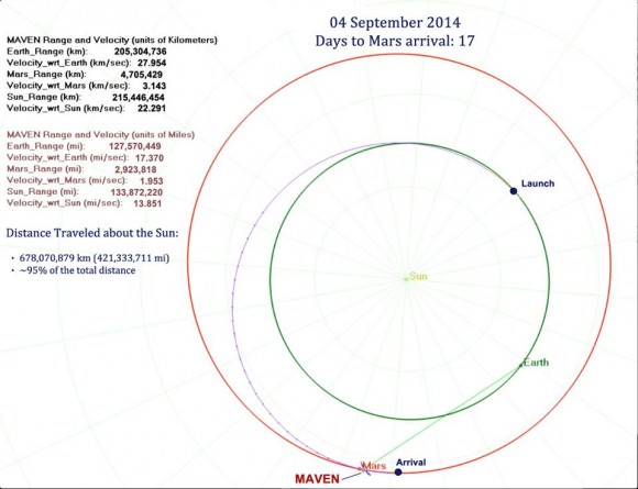
Maven spacecraft trajectory to Mars. Credit: NASA
Maven spacecraft trajectory to Mars on Sept. 4, 2014. Credit: NASA

The $671 Million MAVEN spacecraft’s goal is to study Mars upper atmosphere to explore how the Red Planet lost most of its atmosphere and water over billions of years and the transition from its ancient, water-covered past, to the cold, dry, dusty world that it has become today.

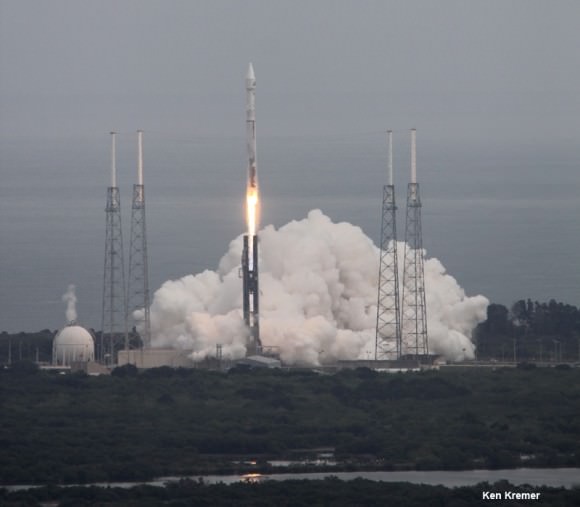
MAVEN soared to space over nine months ago on Nov. 18, 2013 following a flawless blastoff from Cape Canaveral Air Force Station’s Space Launch Complex 41 atop a powerful Atlas V rocket and thus began a 10 month interplanetary voyage from Earth to the Red Planet.

It is streaking to Mars along with ISRO’s MOM orbiter, which arrives a few days later on September 24, 2014.

So far it has traveled 95% of the distance to the Red Planet, amounting to over 678,070,879 km (421,332,902 mi).

As of Sept. 4, MAVEN was 205,304,736 km (127,570,449 miles) from Earth and 4,705,429 km (2,923,818 mi) from Mars. Its Earth-centered velocity is 27.95 km/s (17.37 mi/s or 62,532 mph) and Sun-centered velocity is 22.29 km/s (13.58 mi/s or 48,892 mph) as it moves on its heliocentric arc around the Sun.

One-way light time from MAVEN to Earth is 11 minutes and 24 seconds.

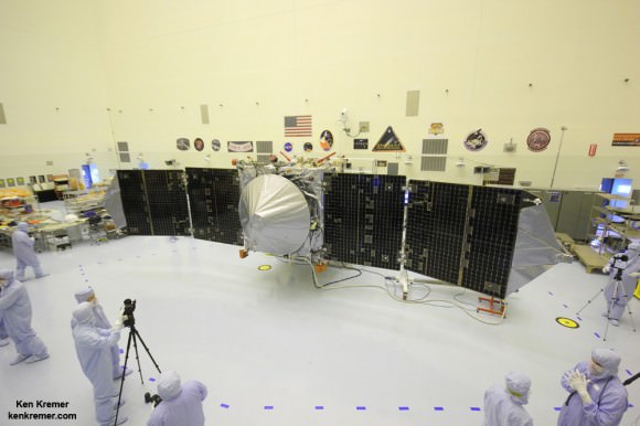
MAVEN is NASA’s next Mars orbiter and launched on Nov. 18, 2014 from Cape Canaveral, Florida. It will study the evolution of the Red Planet’s atmosphere and climate. Universe Today visited MAVEN inside the clean room at the Kennedy Space Center. With solar panels unfurled, this is exactly how MAVEN looks when flying through space and circling Mars and observing Comet Siding Spring. Credit: Ken Kremer/kenkremer.com

Stay tuned here for Ken’s continuing MAVEN, MOM, Rosetta, Opportunity, Curiosity, Mars rover and more Earth and planetary science and human spaceflight news.

Ken Kremer

NASA’s Mars bound MAVEN spacecraft launches atop Atlas V booster at 1:28 p.m. EST from Space Launch Complex 41 at Cape Canaveral Air Force Station on Nov. 18, 2013. Image taken from the roof of the Vehicle Assembly Building (VAB) at NASA’s Kennedy Space Center.  Credit: Ken Kremer/kenkremer.com
NASA’s Mars bound MAVEN spacecraft launches atop Atlas V booster at 1:28 p.m. EST from Space Launch Complex 41 at Cape Canaveral Air Force Station on Nov. 18, 2013. Image taken from the roof of the Vehicle Assembly Building (VAB) at NASA’s Kennedy Space Center. Credit: Ken Kremer/kenkremer.com
NASA’s MAVEN Mars orbiter, chief scientist Prof. Bruce Jakosky of CU-Boulder and Ken Kremer of Universe Today inside the clean room at the Kennedy Space Center on Sept. 27, 2013. MAVEN launches to Mars on Nov. 18, 2013 from Florida. Credit: Ken Kremer/kenkremer.com
NASA’s MAVEN Mars orbiter, chief scientist Prof. Bruce Jakosky of CU-Boulder and Ken Kremer of Universe Today inside the clean room at the Kennedy Space Center on Sept. 27, 2013. MAVEN launched to Mars on Nov. 18, 2013 from Florida. Credit: Ken Kremer/kenkremer.com

Curiosity Celebrates Two Years on Mars Approaching Bedrock of Mountain Climbing Destination

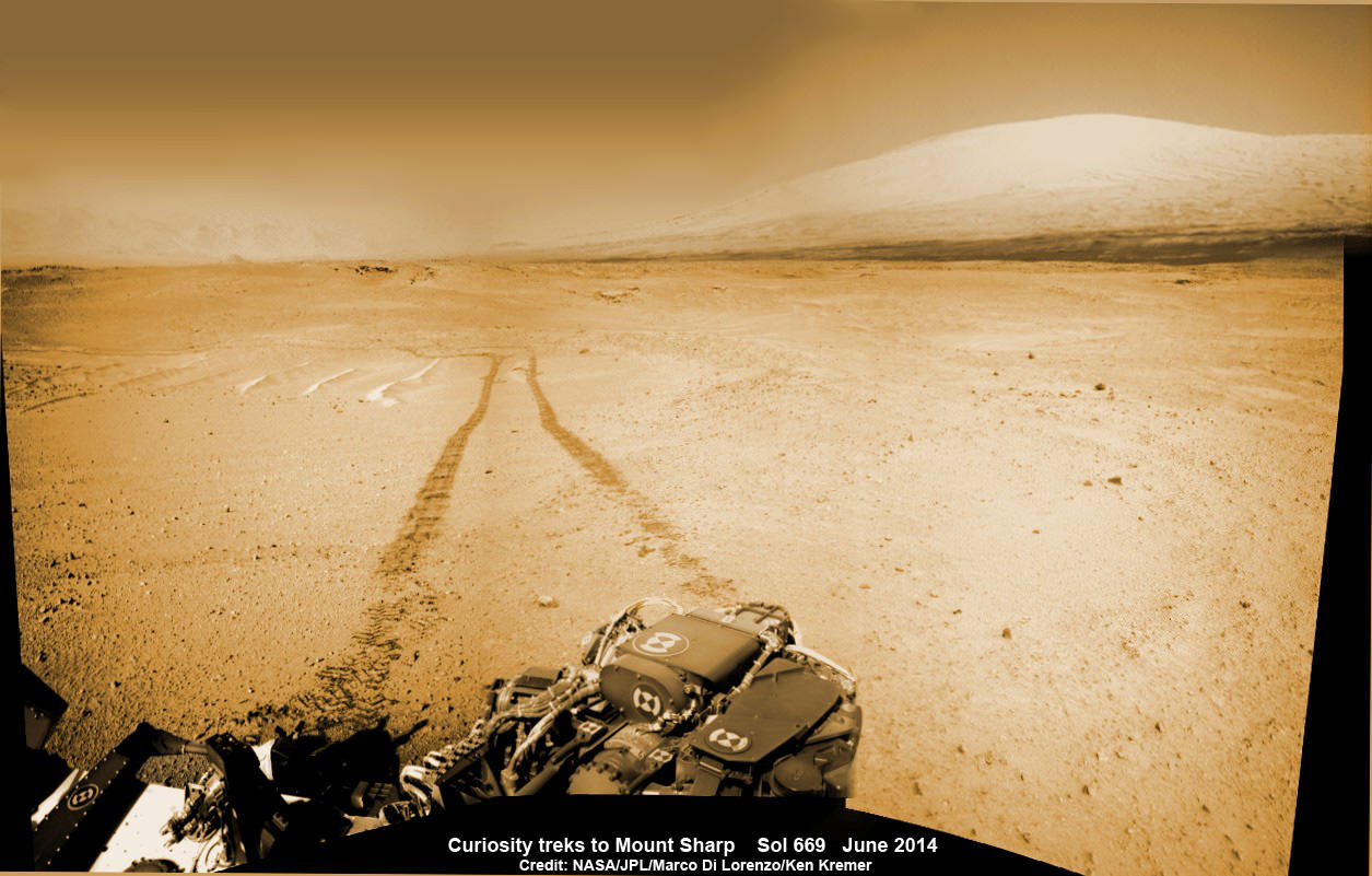
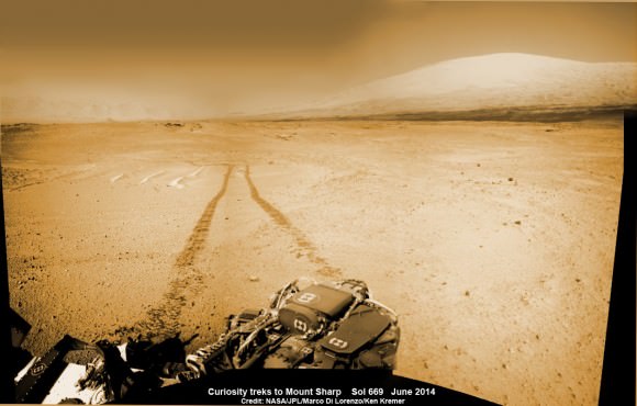
1 Martian Year on Mars! Curiosity treks to Mount Sharp in this photo mosaic view captured on Sol 669, June 24, 2014. Navcam camera raw images stitched and colorized. Credit: NASA/JPL-Caltech/Marco Di Lorenzo/Ken Kremer – kenkremer.com

2 Years on Mars!
Curiosity treks to Mount Sharp, her primary science destination, in this photo mosaic view captured on Sol 669, June 24, 2014. Navcam camera raw images stitched and colorized. Credit: NASA/JPL-Caltech/Marco Di Lorenzo/Ken Kremer – kenkremer.com
Story and mosaics updated[/caption]

NASA’s most scientifically powerful rover ever dispatched to the Red Planet, Curiosity, is celebrating her 2nd anniversary on Mars since the dramatic touchdown inside Gale Crater on Aug. 6, 2012, EDT (Aug. 5, 2012, PDT) while simultaneously approaching a bedrock unit that for the first time is actually part of the humongous mountain she will soon scale and is the primary science destination of the mission.

Mount Sharp is a layered mountain that dominates most of Gale Crater and towers 3.4 miles (5.5 kilometers) into the Martian sky and is taller than Mount Rainier.

Aug. 6, 2014 marks ‘2 Years on Mars’ and Sol 711 for Curiosity in an area called “Hidden Valley.”

“Getting to Mount Sharp is the next big step for Curiosity and we expect that in the Fall of this year,” Dr. Jim Green, NASA’s Director of Planetary Sciences at NASA Headquarters, Washington, DC, told me in an interview making the 2nd anniversary.

The 1 ton rover is equipped with 10 state-of-the-art science instruments and searching for signs of life.

The mysterious mountain is so huge that outcrops of bedrock extend several miles out from its base and Curiosity is now within striking distance of reaching the area the rover team calls “Pahrump Hills.”

2 Earth Years on Mars!  NASA’s Curiosity rover celebrated the 2nd anniversary on Mars at ‘Hidden Valley’ as shown in this photo mosaic view captured on Aug. 6, 2014, Sol 711.  Note the valley walls, rover tracks and distant crater rim. Navcam camera raw images stitched and colorized.  Credit: NASA/JPL-Caltech/Ken Kremer-kenkremer.com/Marco Di Lorenzo
2 Earth Years on Mars!
NASA’s Curiosity rover celebrated the 2nd anniversary on Mars at ‘Hidden Valley’ as shown in this photo mosaic view captured on Aug. 6, 2014, Sol 711. Note the valley walls, rover tracks and distant crater rim. Navcam camera raw images stitched and colorized. Credit: NASA/JPL-Caltech/Ken Kremer-kenkremer.com/Marco Di Lorenzo

Scientists anticipate that the outcrops at “Pahrump Hills” offer a preview of a geological unit that is part of the base of Mount Sharp for the first time since landing rather than still belonging to the floor of Gale Crater.

“We’re coming to our first taste of a geological unit that’s part of the base of the mountain rather than the floor of the crater,” said Curiosity Project Scientist John Grotzinger of the California Institute of Technology, Pasadena, in a statement.

“We will cross a major terrain boundary.”

Since “Pahrump Hills” is less than one-third of a mile (500 meters) from Curiosity she should arrive soon.

In late July 2014, the rover arrived in an area of sandy terrain called “Hidden Valley” which is on the planned route ahead leading to “Pahrump Hills” and easily traversable with few of the sharp edged rocks that have caused significant damage to the rovers six aluminum wheels.

This full-circle panorama of the landscape surrounding NASA's Curiosity Mars rover on July 31, 2014, Sol 705, offers a view into sandy lower terrain called "Hidden Valley," which is on the planned route ahead. It combines several images from Curiosity's Navigation Camera. South is at the center. Credit: NASA/JPL-Caltech
This full-circle panorama of the landscape surrounding NASA’s Curiosity Mars rover on July 31, 2014, Sol 705, offers a view into sandy lower terrain called “Hidden Valley,” which is on the planned route ahead. It combines several images from Curiosity’s Navigation Camera. South is at the center. Credit: NASA/JPL-Caltech

The sedimentary layers in the lower slopes of Mount Sharp have been Curiosity’s long-term science destination.

They are the principal reason why the science team specifically chose Gale Crater as the primary landing site based on high resolution spectral observations collected by NASA’s powerful Mars Reconnaissance Orbiter (MRO) indicating the presence of deposits of clay-bearing sedimentary rocks.

Curiosity’s goal all along has been to determine whether Mars ever offered environmental conditions favorable for microbial life. Finding clay bearing minerals. or phyllosilicates, in Martian rocks is the key to fulfilling its major objective.

The team expected to find the clay bearing minerals only in the sedimentary layers at the lower reaches of Mount Sharp.

Curiosity rover panorama of Mount Sharp captured on June 6, 2014 (Sol 651) during traverse inside Gale Crater.  Note rover wheel tracks at left.  She will eventually ascend the mountain at the ‘Murray Buttes’ at right later this year. Assembled from Mastcam color camera raw images and stitched by Marco Di Lorenzo and Ken Kremer.   Credit:   NASA/JPL/MSSS/Marco Di Lorenzo/Ken Kremer-kenkremer.com
Curiosity rover panorama of Mount Sharp captured on June 6, 2014 (Sol 651) during traverse inside Gale Crater. Note rover wheel tracks at left. She will eventually ascend the mountain at the ‘Murray Buttes’ at right later this year. Assembled from Mastcam color camera raw images and stitched by Marco Di Lorenzo and Ken Kremer. Credit: NASA/JPL/MSSS/Marco Di Lorenzo/Ken Kremer-kenkremer.com

Soon after landing, the team spotted some rather interesting looking outcrops barely a half mile away from the touchdown zone at a spot dubbed ‘Yellowknife Bay” and decided to take a detour towards it to investigate.

Well the scientists won the bet and struck scientific gold barely six months after landing when they drilled into a rock outcrop named “John Klein” at “Yellowknife Bay” and unexpectedly discovered the clay bearing minerals on the crater floor.

Yellowknife Bay was found to be an ancient lakebed where liquid water flowed on Mars surface billions of years ago.

The discovery of phyllosilicates in the 1st drill sample during the spring of 2013 meant that Curiosity had rather remarkably already fulfilled its primary goal of finding a habitable zone during its first year of operations!

The rock analysis “yielded evidence of a lakebed environment billions of years ago that offered fresh water, all of the key elemental ingredients for life, and a chemical source of energy for microbes, if any existed there,” according to NASA.

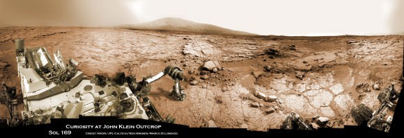
Curiosity accomplished Historic 1st drilling into Martian rock at John Klein outcrop on Feb 8, 2013 (Sol 182) and discovered a habitable zone, shown in this context mosaic view of the Yellowknife Bay basin taken on Jan. 26 (Sol 169). The robotic arm is pressing down on the surface at John Klein outcrop of veined hydrated minerals – dramatically back dropped with her ultimate destination; Mount Sharp. Credit: NASA/JPL-Caltech/Ken Kremer-kenkremer.com/Marco Di Lorenzo

“Before landing, we expected that we would need to drive much farther before answering that habitability question,” said Curiosity Project Scientist John Grotzinger of the California Institute of Technology, Pasadena. “We were able to take advantage of landing very close to an ancient streambed and lake. Now we want to learn more about how environmental conditions on Mars evolved, and we know where to go to do that.”

During the rovers second Earth year on the Red Planet, Curiosity has been driving as fast as possible towards a safe entry point to the slopes of Mount Sharp. The desired destination for the car sized rover is now about 2 miles (3 kilometers) southwest of its current location.

‘Driving, Driving, Driving’
is indeed the rover teams mantra.

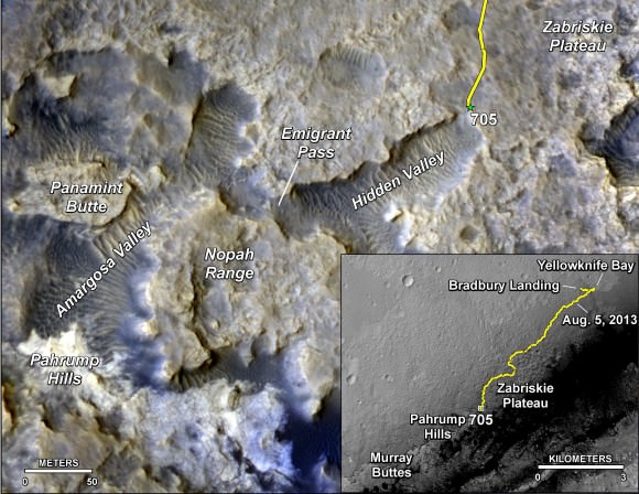
The main map here shows the assortment of landforms near the location of NASA's Curiosity Mars rover as the rover's second anniversary of landing on Mars nears. The gold traverse line entering from upper right ends at Curiosity's position as of Sol 705 on Mars (July 31, 2014). The inset map shows the mission's entire traverse from the landing on Aug. 5, 2012, PDT (Aug. 6, EDT) to Sol 705, and the remaining distance to long-term science destinations near Murray Buttes, at the base of Mount Sharp. The label "Aug. 5, 2013" indicates where Curiosity was one year after landing.    Credit: NASA/JPL-Caltech/Univ. of Arizona
The main map here shows the assortment of landforms near the location of NASA’s Curiosity Mars rover as the rover’s second anniversary of landing on Mars nears. The gold traverse line entering from upper right ends at Curiosity’s position as of Sol 705 on Mars (July 31, 2014). The inset map shows the mission’s entire traverse from the landing on Aug. 5, 2012, PDT (Aug. 6, EDT) to Sol 705, and the remaining distance to long-term science destinations near Murray Buttes, at the base of Mount Sharp. The label “Aug. 5, 2013” indicates where Curiosity was one year after landing. Credit: NASA/JPL-Caltech/Univ. of Arizona

To date, Curiosity’s odometer totals over 5.5 miles (9.0 kilometers) since landing inside Gale Crater on Mars in August 2012. She has taken over 174,000 images.

Curiosity still has about another 2 miles (3 kilometers) to go to reach the entry way at a gap in the treacherous sand dunes at the foothills of Mount Sharp sometime later this year.

And NASA is moving forward with future Red Planet missions when it recently announced the selection of 7 instruments chosen to fly aboard the Mars 2020 rover, the agency’s next rover going to Mars that will search for signs of ancient life as well as carry a technology demonstration that will help pave the way for ‘Humans to Mars’ in the 2030s. Read my story – here.

Coincidentally, ESA’s Rosetta comet hunting spacecraft arrived in orbit at its destination Comet 67P after a 10 year voyage on the same day as Curiosity’s 2 Earth year anniversary.

Stay tuned here for Ken’s continuing Rosetta, Curiosity, Opportunity, Orion, SpaceX, Boeing, Orbital Sciences, commercial space, MAVEN, MOM, Mars and more planetary and human spaceflight news.

Ken Kremer

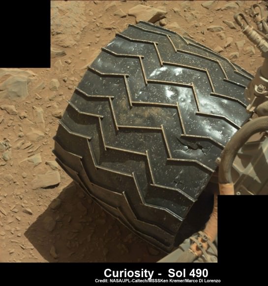
Up close view of hole in one of rover Curiosity’s six wheels caused by recent driving over rough Martian rocks. Mosaic assembled from Mastcam raw images taken on Dec. 22, 2013 (Sol 490).  Credit: NASA/JPL/MSSS/Ken Kremer - kenkremer.com/Marco Di Lorenzo
Up close view of hole in one of rover Curiosity’s six wheels caused by recent driving over rough Martian rocks. Mosaic assembled from Mastcam raw images taken on Dec. 22, 2013 (Sol 490). Credit: NASA/JPL/MSSS/Ken Kremer – kenkremer.com/Marco Di Lorenzo

Curiosity Captured from Orbit Crossing Landing Ellipse Boundary – Martian Scenery from Above and Below

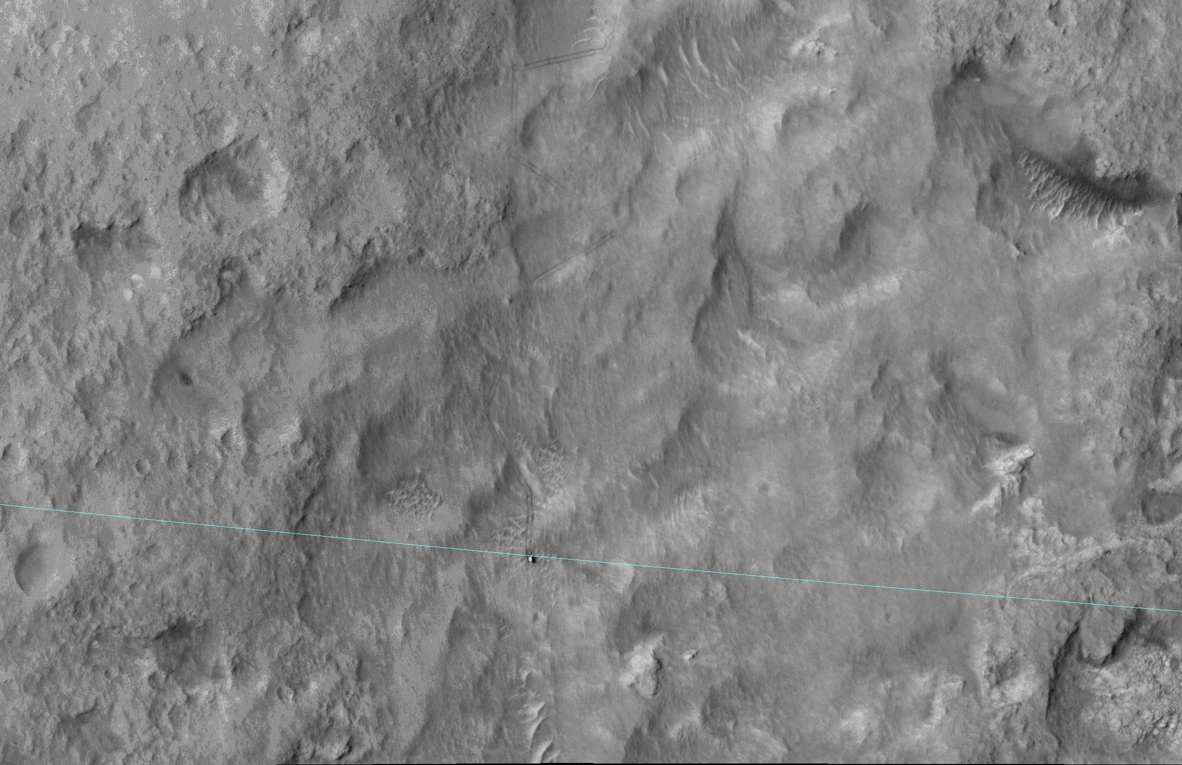
This June 27, 2014, image from the HiRISE camera on NASA's Mars Reconnaissance Orbiter shows NASA's Curiosity Mars rover on the rover's landing-ellipse boundary, which is superimposed on the image. The 12-mile-wide ellipse was mapped as safe terrain for its 2012 landing inside Gale Crater. Image Credit: NASA/JPL-Caltech/Univ. of Arizona

NASA has now released a breathtaking high resolution image of the rover Curiosity captured from Mars orbit coincidentally coinciding with her crossing the targeted landing ellipse just days after she marked ‘1 Martian Year’ on the Red Planet in search of the chemical ingredients necessary to support alien microbial life forms.

The orbital image was taken on June 27 (Sol 672) by the High Resolution Imaging Science Experiment (HiRISE) camera on NASA’s Mars Reconnaissance Orbiter (MRO) and clearly shows the rover and wheel tracks at the end of the drive that Sol, or Martian day.

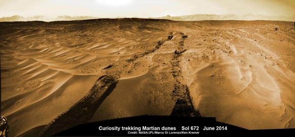
You can simultaneously experience the Martian eye view of Curiosity from above and below by checking out our Sol 672 ground level photo mosaic – below. It’s assembled from raw images taken by the mast mounted navigation camera (Navcam) showing the rovers wheel tracks and distant rim of the Gale Crater landing site.

Curiosity treks across Martian dunes and drives outside landing ellipse here, in this photo mosaic view captured on Sol 672, June 27, 2014.    Navcam camera raw images stitched and colorized.   Credit: NASA/JPL-Caltech/Marco Di Lorenzo/Ken Kremer – kenkremer.com
Curiosity treks across Martian dunes and drives outside landing ellipse here, in this photo mosaic view captured on Sol 672, June 27, 2014. Navcam camera raw images stitched and colorized. Credit: NASA/JPL-Caltech/Marco Di Lorenzo/Ken Kremer – kenkremer.com

The six wheeled robot drove about 269 feet (82 meters) on June 27 traversing to the boundary of her targeted landing ellipse in safe terrain – approximately 4 miles wide and 12 miles long (7 kilometers by 20 kilometers) – for the first time since touchdown on Mars nearly two years ago on August 5, 2012 inside Gale Crater.

Curiosity celebrated another Martian milestone anniversary on June 24 (Sol 669) – 1 Martian Year on Mars!

A Martian year is equivalent to 687 Earth days, or nearly two Earth years.

1 Martian Year on Mars!  Curiosity treks to Mount Sharp in this photo mosaic view captured on Sol 669, June 24, 2014.    Navcam camera raw images stitched and colorized.   Credit: NASA/JPL-Caltech/Marco Di Lorenzo/Ken Kremer – kenkremer.com
1 Martian Year on Mars!
Curiosity treks to Mount Sharp in this photo mosaic view captured on Sol 669, June 24, 2014. Navcam camera raw images stitched and colorized. Credit: NASA/JPL-Caltech/Marco Di Lorenzo/Ken Kremer – kenkremer.com

The SUZ sized rover is driving as swiftly as possible to the base of Mount Sharp which dominates the center of Gale Crater and reaches 3.4 miles (5.5 km) into the Martian sky – taller than Mount Rainier.

During Year 1 on Mars, Earth’s emissary has already accomplished her primary objective of discovering a habitable zone on the Red Planet that contains the minerals necessary to support microbial life in the ancient past when Mars was far wetter and warmer billions of years ago.

To date, Curiosity’s odometer totals over 5.1 miles (8.4 kilometers) since landing inside Gale Crater on Mars in August 2012. She has taken over 165,000 images.

Curiosity still has about another 2.4 miles (3.9 kilometers) to go to reach the entry way at a gap in the treacherous sand dunes at the foothills of Mount Sharp sometime later this year.

Stay tuned here for Ken’s continuing Curiosity, Opportunity, Orion, SpaceX, Boeing, Orbital Sciences, commercial space, MAVEN, MOM, Mars and more planetary and human spaceflight news.

Ken Kremer

Mars’ Dingo Gap Seen From Orbit and the Ground

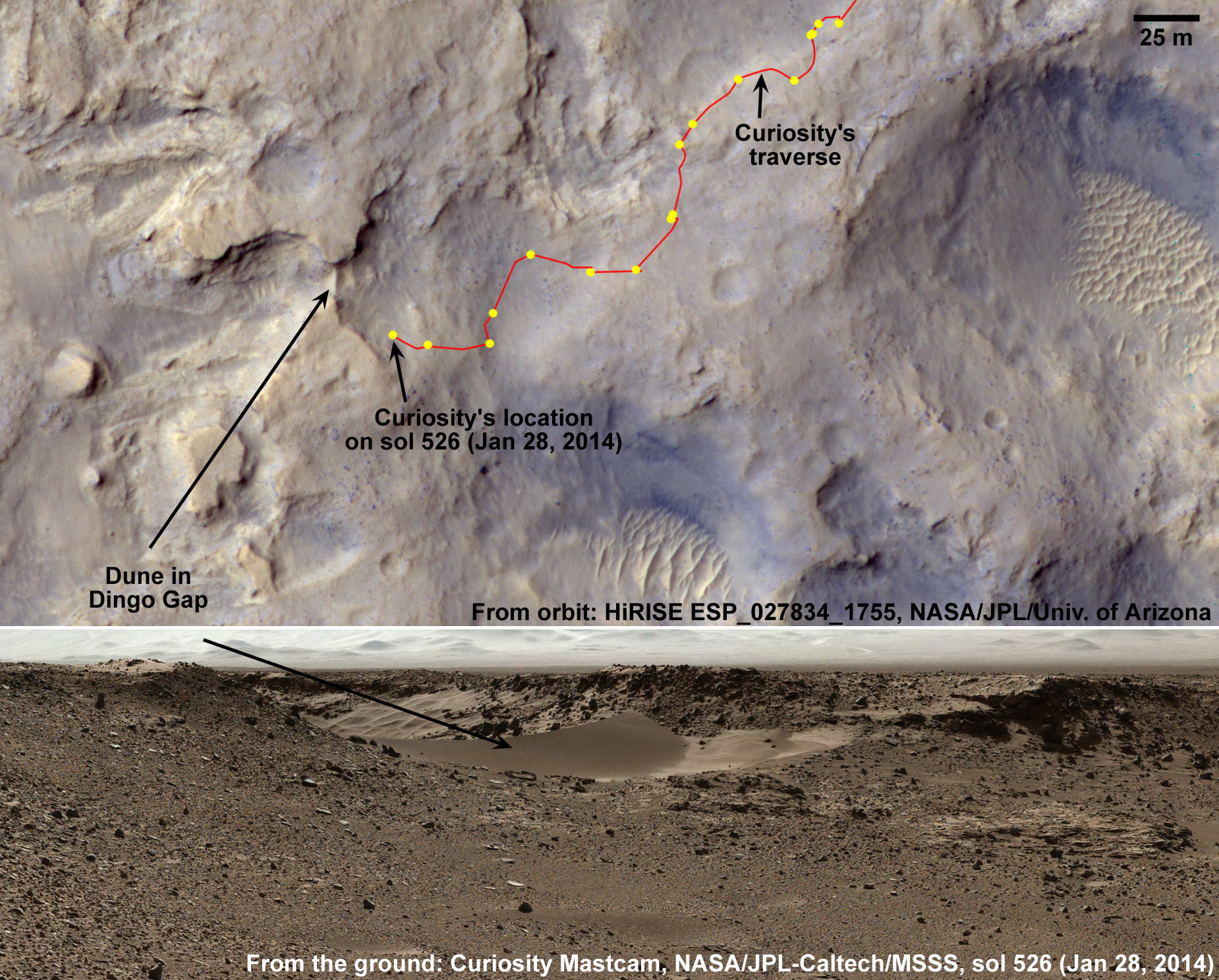
An orbital view from the Mars Reconnaissance Orbiter of the Curiosity rover's traverse through the Dingo Gap area of Gale crater, (top), along with a ground view from Curiosity's mastcam. Credit: NASA/JPL/University of Arizona.

Thanks to the Mars Reconnaissance Orbiter and the HiRISE camera, we have an orbital view of Dingo Gap, an opening between two low scarps which is spanned by a single dune. This gap and dune are visible both from the ground and from orbit. The Curiosity Mars rover has now crossed the gap and is continuing its travels toward enticing science destinations, including interesting veins and mineral fractures.

In the orbital image from HiRISE, the rover itself is not in this image as it was acquired before MSL landed. However, the imagery was likely used to help the rover team decide on the way to travel.

Below are more images of Dingo gap before and after the rover plowed its way through the sand.

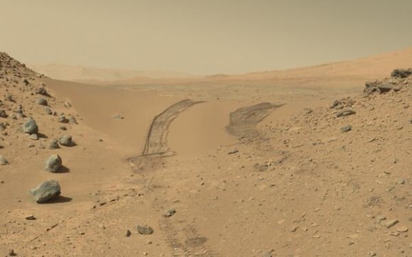
The Curiosity rover looks back at the tracks it left after crossing through the Dingo Gap sand dune. Credit: NASA/JPL, Caltech. Via Doug Ellison on Twitter.
The series of nine images making up this animation were taken by the rear Hazard-Avoidance Camera (rear Hazcam) on NASA’s Curiosity Mars rover as the rover drove over a dune spanning “Dingo Gap” on Mars. Image credit: NASA/JPL-Caltech
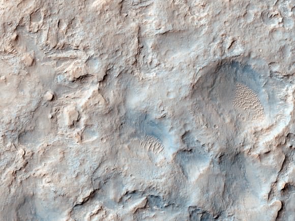
The orbital view of Gale Crater and the Dingo Gap region. Credit: NASA/JPL/University of Arizona.
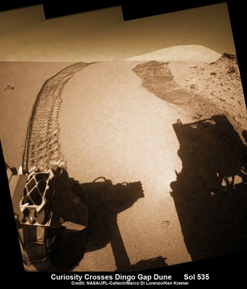
Curiosity looks back to ‘Dingo Gap’ sand dune after crossing over, backdropped by Mount Sharp on Sol 535, Feb. 5, 2014.  Hazcam fisheye image linearized and colorized.  Credit: NASA/JPL/Marco Di Lorenzo/Ken Kremer- kenkremer.
Curiosity looks back to ‘Dingo Gap’ sand dune after crossing over, backdropped by Mount Sharp on Sol 535, Feb. 5, 2014. Hazcam fisheye image linearized and colorized. Credit: NASA/JPL/Marco Di Lorenzo/Ken Kremer- kenkremer.
Curiosity’s view to valley beyond after crossing over ‘Dingo Gap’ sand dune. This photomosaic was taken after Curiosity drove over the 1 meter tall Dingo Gap sand dune and shows dramatic scenery in the valley beyond, back dropped by eroded rim of Gale Crater. Assembled from navigation camera (navcam) raw images from Sol 535 (Feb. 6, 2104) Credit: NASA/JPL-Caltech/Ken Kremer- kenkremer.com/Marco Di Lorenzo

Brand New Impact Crater Shows Up on Mars

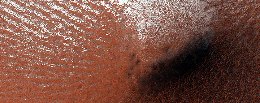
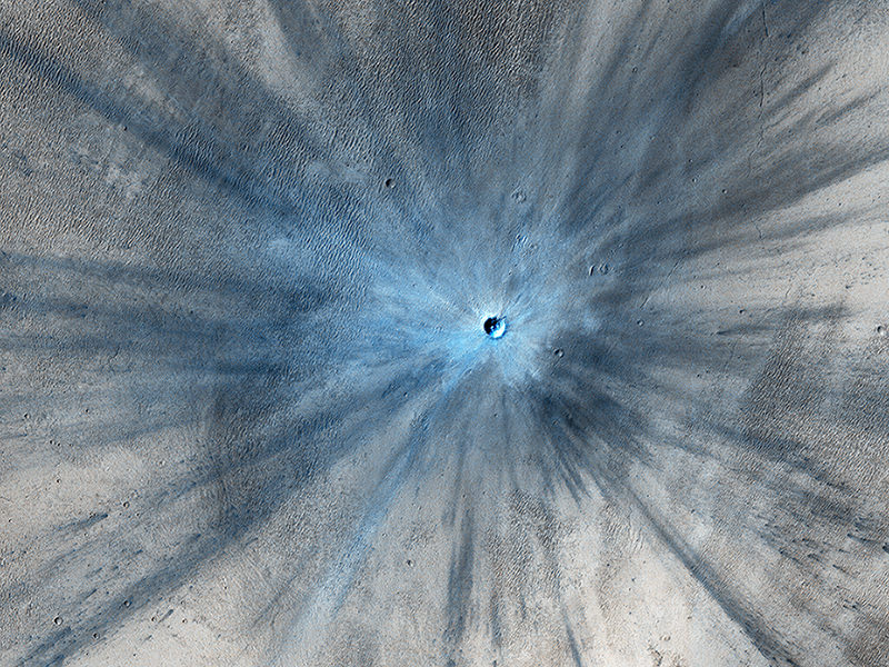
A fresh impact crater is seen in this image taken by the High Resolution Imaging Science Experiment (HiRISE) camera on NASA's Mars Reconnaissance Orbiter on Nov. 19, 2013. Credit: NASA/JPL/University of Arizona

The great thing about the longevity of the Mars Reconnaissance Orbiter is that we can see changes taking place on the Red Planet, such as this relatively new and rather large impact crater. This image shows a stunning 30-meter-wide crater with a rayed blast zone and far-flung secondary material surrounding. Scientists say the impact and resulting explosion threw debris as far as 15 kilometers in distance.

Before and after pictures of this region show the new impact crater formed between July 2010 and May 2012.

The image has been enhanced in false color and so the fresh crater appears blue because of the lack of reddish dust that covers most of Mars’ surface.

With MRO’s help, scientists have been able to estimate that Mars gets pummeled with about 200 impacts per year, but most are much smaller than this new one.

The usual procedure for finding new craters is that MRO’s Context Camera, or CTX, or cameras on other orbiters identify anomalies or dark spots that appear in new images and then MRO’s High Resolution Imaging Science Experiment (HiRISE) camera is targeted to follow up by imaging those dark spots in greater detail.

More info on this new image can be found here.