Picture of Earth from Space

Earth
Earth

Looking for a picture of Earth from Space? Here is a collection.

[/caption]

Here’s a spectacular image of the earth with the full coverage of the Pacific Ocean. This image was obtained by the Galileo spacecraft on December 12, 1990 while on its way to planet Jupiter 1.6 million miles from the Earth.

The Blue Marble from Apollo 17

This is a spectacular full view of our planet earth. It was taken by the Apollo 17 during their journey to the moon in December 7, 1972. The south polar ice cap of Antarctica can be clearly seen in the image. This region constitutes 70% of the world’s freshwater. This photo of the earth was the first to feature the south polar ice cap.

A Stormy Atlantic
A Stormy Atlantic

Here’s an image of different storms and hurricanes forming at the Atlantic Ocean. This image was generated using the data provided by the Geostationary Operational Environmental Satellite (GOES) satellite on September 3, 2008.

Earth - Western Hemisphere

Here’s a nice view of the earth particularly focusing on the Western Hemisphere. Earth is the third planet from the sun and is the only place in the universe where life is known to exist.

The Earth-Moon System

This is a nice view of the planet earth and the moon in one frame as seen from the Galileo spacecraft 6.2 million kilometers away.

Picture of Earth from Space

Here’s a picture of Earth from Space as well as the Moon. These images were taken separately and then stitched together on computer to show them together.

Earth from Space
Earth from Space

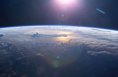
This picture was taken by the Space Shuttle, and shows the Earth from high orbit. You can see how the clouds rise up into the atmosphere.

Earth from space
Earth from space

Here’s another picture of Earth. Again, this was taken from the space shuttle.

NASA satellite map of the Earth

This is a satellite map that shows all of the Earth.

Blue marble Earth. Image credit: NASA
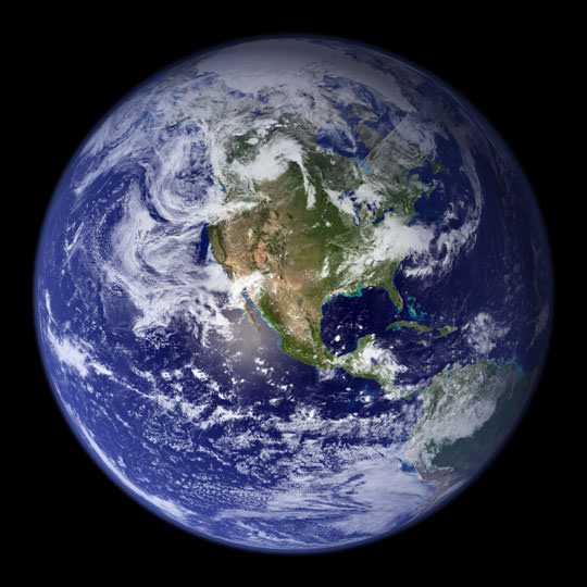
This is the classic “Blue Marble” photo of Earth.

Earth from Space at Night

Earth from Space at Night

Here’s a photo of the entire Earth, seen from space at night. You can easily see cities and towns in North America, Asia and Europe. And you can also see vast regions of the Earth which are totally dark.


Chicago at night
Chicago at night

Here’s a photo of the city of Chicago at night. It might look upside down, but that’s because it was captured from the International Space Station as it was passing over the city.


Tokyo at night
Tokyo at night

This night space image shows the city of Tokyo at night. The blue green glow in the photograph comes from the mercury vapor lighting that lines the streets of the city.


London at night
London at night

This space pic from night shows the city of London. You can see the brightest areas are the most densely populated, and the less dense areas are dimmer. You can see the ring road that surrounds London, as well as the path of the Thames river.


Los Angeles at night

Here’s one of the brightest cities in the world. It’s Los Angeles from space, seen at night.

Earth at Night Wallpaper
A Crescent Earth at Midnight

Here’s an amazing picture of the earth in crescent. This breathtaking view of our planet was obtained by the Geostationary Operational Environmental Satellite (GOES-8) on June 22, 1996. GOES is primarily assigned in monitoring the weather particularly the development of storms and hurricanes in different parts of the earth.

Earth at Twilight
Earth at Twilight

This is an amazing still photo of the earth taken during its transition from day to night. This beautiful photo was taken from the International Space Station in June 2001.

All Is Illuminated
All Is Illuminated

This spectacular image of the crescent earth was captured by the Optical Spectroscopic and Infrared Remote Imaging System (OSIRIS) camera on board the Rosetta spacecraft in November 2007.

Houston, Texas at Night

Here’s a nice view of Houston, Texas at night as seen from the International Space Station on February 28, 2010. This photo was taken by the crew member of the Expedition 22 mission. Houston, Texas is the world’s energy capital.

Earth from Orbit

Earth from Orbit
Manicouagan Reservoir. Credit: NASA

Here’s an image of the Manicougan Reservoir situated at Canadian Shield in the province of Quebec. This was taken from the International Space Station in December 1983. Manicougan Reservoir covers an area of about 1,942 kmĀ².

Sunset
Sunset

This image of the sunset on earth was captured from the International Space Station by an Expedition 13 astronaut in August 10, 2006. Expedition 13 mission was able to accomplish a total of 2,886 orbits.

Expedition 11 Earth Observation Photos

This photo shows the Central Gulf Coast obtained from the International Space Station by an Expedition 11 astronaut in September 10, 2005.

Into the Eye of the Storm

This is a photo of the eye of Hurricane Alberto taken in August 19, 2000 during the Terra orbit 3571. Hurricane Alberto is a Category 3 hurricane in the Atlantic that lasted for 19.75 days.

Hurricane Emily and the Moon

This beautiful view of the eye of Hurricane Emily and the moon was captured from the International Space Station in July 16, 2005. Hurricane Emily is a Category 5 hurricane having a maximum wind speed of 160 mph.

Earth from the Space Shuttle

Earth from Space Shuttle
Sunrise in Space

This photo of the earth’s atmosphere during sunrise was taken in July 2005 by a Discovery crew member during the STS-114 mission. STS-114 mission was the first Return to Flight mission after the unfortunate loss of the Columbia space shuttle.

Onboard View - Space Shuttle Endeavour

This image of the earth was taken from the space shuttle Endeavor during the STS-59 mission in April 12, 1994. The image particularly shows the shuttle’s payload bay and the region of the Andes Mountains in Bolivia.

Sinai Peninsula and the Mediterranean Sea

Here’s a stunning image of the Sinai Peninsula and the Mediterranean Sea as seen from the space shuttle Atlantis. A crew member of the STS-125 mission took this photo during the mission’s first flight in space.

View of the Journey Home

Here’s a unique photo of the earth’s atmosphere taken by the crew members of Atlantis’ STS-125 mission during its preparation for landing on May 20, 2009.

STS-39 view of the Aurora Australis

Here’s a great view of the Aurora Australis taken in May 1991 by the STS-39 crew member onboard the space shuttle.

We have written many articles about pictures of Earth from Space for Universe Today. Here’s a story about the Earth from space at night, and here’s an article about images of cities from space.

You can get many more images of Earth from space at NASA’s Earth Observatory website.

We have recorded a whole episode of Astronomy Cast about our planet. Listen to it here, Episode 51: Earth.

Heat-Shocked Diamonds Provide New Clue of Horse-Killing Impact

California's Channel Islands, where heat-shocked soot and diamonds are suggesting a killing comsic impact. Courtesy NOAA and UC Santa Barbara

[/caption]

Archeologists have been divided about whether an extraterrestiral impact blasted North America about 12,900 years ago, wreaking havoc on Earth’s surface and sending scores of species — including a pygmy mammoth and the horse — into oblivion.

New clues from California’s Channel Islands should put any doubt to rest, says an international team of researchers.

This transmission electron microscopy close-up shows a single lonsdaleite crystal, left, and associated diffraction pattern. Credit: University of Oregon

TheĀ 17-member team, led by University of Oregon archaeologist Douglas J. Kennett,Ā has found what may be the smoking gun.

The team has found shock-synthesized hexagonal diamonds in 12,900-year-old sediments on the Northern Channel Islands off the southern California coast.

The tiny diamonds and diamond clusters were buried deeply below four meters (13 feet) of sediment. They date to the end of Clovis — a Paleoindian culture long thought to be North America’s first human inhabitants. The nano-sized diamonds were pulled from Arlington Canyon on the island of Santa Rosa, which had once been joined with three other Northern Channel Islands in a landmass known as Santarosae.

The diamonds were found in association with soot that forms in extremely hot fires, and they suggest associated regional wildfires, based on nearby environmental records.

Such soot and diamonds are rare in the geological record. They were found in sediment dating to massive asteroid impacts 65 million years ago in a layer widely known as the K-T Boundary. The thin layer of iridium-and-quartz-rich sediment dates to the transition of the Cretaceous and Tertiary periods, which mark the end of the Mesozoic Era and the beginning of the Cenozoic Era.

“The type of diamond we have found — Lonsdaleite — is a shock-synthesized mineral defined by its hexagonal crystalline structure. It forms under very high temperatures and pressures consistent with a cosmic impact,” Kennett said. “These diamonds have only been found thus far in meteorites and impact craters on Earth and appear to be the strongest indicator yet of a significant cosmic impact [during Clovis].”

The age of this event also matches the extinction of the pygmy mammoth on the Northern Channel Islands, as well as numerous other North American mammals, including the horse, which Europeans later reintroduced. In all, an estimated 35 mammal and 19 bird genera became extinct near the end of the Pleistocene with some of them occurring very close in time to the proposed cosmic impact, first reported in October 2007 in PNAS.

Source: University of Oregon, via Eurekalert. The results appear in a paper online ahead of print in theĀ Proceedings of the National Academy of Sciences.

Solar Cycle Triggers La Nina, El Nino-like Climate Shifts

[/caption]

Researchers have discovered a link between the 11-year solar cycle and tropical Pacific weather patterns that resemble La NiƱa and El NiƱo events.

When it comes to influencing Earth’s climate, the Sun’s variability pales in recent decades compared to greehouse gasesĀ — but the new research shows it still plays a distinguishable part.

The total energy reaching Earth from the sun varies by only 0.1 percent across the solar cycle. Scientists have sought for decades to link these ups and downs to natural weather and climate variations and distinguish their subtle effects from the larger pattern of human-caused global warming.

Co-authors Gerald Meehl and Julie Arblaster, both affiliated with the National Center for Atmospheric Research in Boulder, Colorado, analyzed computer models of global climate and more than a century of ocean temperature records.Ā ArblasterĀ is also affiliated with the Australian Bureau of Meteorology.

In the new paper and a previous one with additional colleagues, the researchers have been able to show that, as the sun’s output reaches a peak, the small amount of extra sunshine over several years causes a slight increase in local atmospheric heating, especially across parts of the tropical and subtropical Pacific where Sun-blocking clouds are normally scarce.

That small amount of extra heat leads to more evaporation, producing extra water vapor. In turn, the moisture is carried by trade winds to the normally rainy areas of the western tropical Pacific, fueling heavier rains.

As this climatic loop intensifies, the trade winds strengthen. That keeps the eastern Pacific even cooler and drier than usual, producing La NiƱa-like conditions.

“We have fleshed out the effects of a new mechanism to understand what happens in the tropical Pacific when there is a maximum of solar activity,” Meehl said. “When the sun’s output peaks, it has far-ranging and often subtle impacts on tropical precipitation and on weather systems around much of the world.”

The result of this chain of events is similar to a La NiƱa event, although the cooling of about 1-2 degrees Fahrenheit is focused further east and is only about half as strong as for a typical La NiƱa.

True La NiƱa and El Nino events are associated with changes in the temperatures of surface waters of the eastern Pacific Ocean. They can affect weather patterns worldwide.

Although the Pacific pattern in the new paper is produced by the solar maximum, the authors found that its switch to an El NiƱo-like state is likely triggered by the same kind of processes that normally lead from La NiƱa to El NiƱo.

The transition starts when the changes of the strength of the trade winds produce slow-moving off-equatorial pulses known as Rossby waves in the upper ocean, which take about a year to travel back west across the Pacific.

The energy then reflects from the western boundary of the tropical Pacific and ricochets eastward along the equator, deepening the upper layer of water and warming the ocean surface.

As a result, the Pacific experiences an El NiƱo-like event about two years after solar maximum — also about half as strong as a true El NiƱo. The event settles down after about a year, and the system returns to a neutral state.

“El NiƱo and La NiƱa seem to have their own separate mechanisms,” Meehl said, “but the solar maximum can come along and tilt the probabilities toward a weak La NiƱa. If the system was heading toward a La NiƱa anyway,” he adds, “it would presumably be a larger one.”

The study authors say the new research may pave the way toward predictions of temperature and precipitation patterns at certain times during the approximately 11-year solar cycle.

In an email, Meehl noted that previous work by his team and other research groups has shown that “most of the warming trend in the first half of the 20th Century was due to an increasing trend of solar output, while most of the warming trend in the last half of the 20th Century and ever since has been due to ever-increasing GHG (greenhouse gas) concentrations in the atmosphere from the burning of fossil fuels.”

The new paper appears this month in theĀ Journal of Climate, a publication of the American Meteorological Society. (Sorry, it’s not yet available online.)

Source: Eurekalert

Ancient Domes Reveal 3.45-billion-year-old Life History

[/caption]

Ancient, dome-like rock structures contain clues that life was active on Earth 3.45 billion years ago, according to new research — and the findings could help shed light on life’s history on Earth and other planets, including Mars.

Abigail Allwood, who studies planetary habitability at NASA’s Jet Propulsion Laboratory, led the research. She and her colleagues studied stromatolites, which are dome- or column-like sedimentary rock structures formed in shallow water, layer by layer, over long periods of geologic time.

Geologists have long known that the large majority of the relatively young stromatolites they studyā€”those half a billion years old or soā€”have a biological origin; they’re formed with the help of layers of microbes that grow in a thin film on the seafloor.Close-up, cross-section view of the interior of a domical stromatolite. The black layers are the "cooked" organic remains of Early Archean microbial mats.  Credit: Abigail Allwood

The microbes’ surface is coated in a mucilaginous substance to which sediment particles rolling past get stuck.

“It has a strong flypaper effect,” said John Grotzinger, a CaltechĀ geologist and a study co-author. In addition, the microbes sprout a tangle of filaments that almost seem to grab the particles as they move along.Ā “The end result,” Grotzinger explains, “is that wherever the mat is, sediment gets trapped.”

So in a young stromalite, dark bandsĀ like those seen in the close-up cross section at left indicate organic material. ButĀ 3.45 billion years ago, in the early Archean period of geologic history, things weren’t quite so simple.

“Because stromatolites from this period of time have been around longer, more geologic processing has happened,” Grotzinger says. Pushed deeper toward the center of Earth as time went by, these stromatolites were exposed to increasing, unrelenting heat. This is a problem when it comes to examining the stromatolites’ potential biological beginnings, he explains, because heat degrades organic matter. “The hydrocarbons are driven off,” he says. “What’s left behind is a residue of nothing but carbon.”

As such, geologists debate whether or not the carbon found in these ancient rocks is diagnostic of life.

Allwood and her team turned to the texture and morphology of the rocks themselves, from samples gathered in Western Australia. The samples, says Grotzinger, were “incredibly well preserved.” Dark lines of what was potentially organic matter were “clearly associated with the lamination, just like we see in younger rocks. That sort of relationship would be hard to explain without a biological mechanism.”

Allwood set about trying to find other types of evidence. She looked at what she calls the “microscale textures and fabrics in the rocks, patterns of textural variation through the stromatolites andā€”importantlyā€”organic layers that looked like actual fossilized organic remnants of microbial mats within the stromatolites.”

She saw “discrete, matlike layers of organic material that contoured the stromatolites from edge to edge, following steep slopes and continuing along low areas without thickening.” She also found pieces of microbial mat incorporated into storm deposits, which disproved the idea that the organic material had been introduced into the rock more recently, rather than being laid down with the original sediment.

“In addition,” Allwood notes, “Raman spectroscopy showed that the organics had been ‘cooked’ to the same burial temperature as the host rock, again indicating the organics are not young contaminants.”

Allwood said she, Grotzinger, and their team have collected enough evidence that it’s no longer a great leap to accept the stromatolites as biological in origin. And the researchers say the implications of the findings don’t stop at life on Earth.

“One of my motivations for understanding stromatolites,” Allwood says, “is the knowledge that if microbial communities once flourished on Mars, of all the traces they might leave in the rock record for us to discover, stromatolite and microbial reefs are arguably the most easily preserved and readily detected. Moreover, they’re particularly likely to form in evaporative, mineral-precipitating settings such as those that have been identified on Mars. But to be able to interpret stromatolitic structures, we need a much more detailed understanding of how they form.”

Both images courtesy of Abigail Allwood.

Source: Eurekalert, a media service of the American Association for the Advancement of Science (AAAS). The research appeared in online June 10 and in print June 16 in the Proceedings of the National Academy of Sciences (PNAS).

More Atmospheric CO2 Today Than in the Past 2.1 Millions Years

Earth from space. Credit: NASA

[/caption]
Researchers have been able to determine the atmospheric carbon dioxide levels over the past 2.1 million years in the sharpest detail yet by analyzing the shells of singleā€“celled plankton. Their findings shed new light on CO2’s role in the earth’s cycles of cooling and warming, confirming many researchers’ suspicions that higher carbon dioxide levels coincided with warmer intervals during the study period. But it also rules out a drop in CO2 as the cause for earth’s ice ages growing longer and more intense some 850,000 years ago.

The study, published in the June 19 issue of the journal Science shows that peak CO2 levels over the last 2.1 million years averaged only 280 parts per million; but today, CO2 is at 385 parts per million, or 38% higher. This finding means that researchers will need to look back further in time for an analog to modern day climate change.

BƤrbel Hƶnisch diving for plankton in an early phase of the study.  Credit: Steve Doo
BƤrbel Hƶnisch diving for plankton in an early phase of the study. Credit: Steve Doo

In the study, BƤrbel Hƶnisch, a geochemist at Lamont-Doherty Earth Observatory, and her colleagues reconstructed CO2 levels by analyzing the shells of single-celled plankton buried under the Atlantic Ocean, off the coast of Africa. By dating the shells and measuring their ratio of boron isotopes, they were able to estimate how much CO2 was in the air when the plankton were alive. This method allowed them to see further back than the precision records preserved in cores of polar ice, which go back only 800,000 years.

Around 850,000 years ago, the climate cycles on Earth switched from being dominated by 40,000 year cycles, to the stronger 100,000 year cycles of the more recent times. The time period from 800 ā€“ 1,000 kyr ago is called the mid-Pleistocene transition, and since the rhythms of the Earthā€™s orbit didnā€™t change, some scientists have attributed that shift to falling CO2 levels. But the study found that CO2 was flat during this transition and unlikely to have triggered the change.

“Previous studies indicated that CO2 did not change much over the past 20 million years, but the resolution wasn’t high enough to be definitive,” said Hƶnisch. “This study tells us that CO2 was not the main trigger, though our data continues to suggest that greenhouse gases and global climate are intimately linked.”

The timing of the ice ages is believed to be controlled mainly by the earth’s orbit and tilt, which determines how much sunlight falls on each hemisphere. Two million years ago, the earth underwent an ice age every 41,000 years. But some time around 850,000 years ago, the cycle grew to 100,000 years, and ice sheets reached greater extents than they had in several million yearsā€”a change too great to be explained by orbital variation alone.

Barbel Honisch with a mass spectrometer used to measure boron isotopes to reconstruct past CO2.  Credit: Lamont-Doherty Earth Observatory
Barbel Honisch with a mass spectrometer used to measure boron isotopes to reconstruct past CO2. Credit: Lamont-Doherty Earth Observatory

A global drawdown in CO2 is just one theory proposed for the transition. A second theory suggests that advancing glaciers in North America stripped away soil in Canada, causing thicker, longer lasting ice to build up on the remaining bedrock. A third theory challenges how the cycles are counted, and questions whether a transition happened at all.

The low carbon dioxide levels outlined by the study through the last 2.1 million years make modern day levels, caused by industrialization, seem even more anomalous, says Richard Alley, a glaciologist at Pennsylvania State University, who was not involved in the research.

“We know from looking at much older climate records that large and rapid increase in C02 in the past, (about 55 million years ago) caused large extinction in bottom-dwelling ocean creatures, and dissolved a lot of shells as the ocean became acidic,” he said. “We’re heading in that direction now.”

The idea to approximate past carbon dioxide levels using boron, an element released by erupting volcanoes and used in household soap, was pioneered over the last decade by the paper’s coauthor Gary Hemming, a researcher at Lamont-Doherty and Queens College. The study’s other authors are Jerry McManus, also at Lamont; David Archer at the University of Chicago; and Mark Siddall, at the University of Bristol, UK.

Source: EurekAlert

History of Iron Yields New Insight Into Earth’s Deepest Reaches

Credit: Louise Kellogg, modified by James Rustad & Qing-zhu Yin/UC Davis

[/caption]

Earth may have given up its innermost secrets to a pair of California geochemists, who have used extensive computer simulations to piece together the earliest history of our planet’s core.

This schematic of Earthā€™s crust and mantle shows the results of their study, which found extreme pressures would have concentrated ironā€™s heavier isotopes near the bottom of the mantle as it crystallized from an ocean of magma.

World Book illustration by Raymond Perlman and Steven Brayfield, Artisan-Chicago

By using a super-computer to virtually squeeze and heat iron-bearing minerals under conditions that would have existed when the Earth crystallized from an ocean of magma to its solid form 4.5 billion years ago, the two scientists — from the University of California at Davis — have produced the first picture of how different isotopes of iron were initially distributed in the solid Earth.

The discovery could usher in a wave of investigations into the evolution of Earth’s mantle, a layer of material about 1,800 miles deep that extends from just beneath the planet’s thin crust to its metallic core.

“Now that we have some idea of how these isotopes of iron were originally distributed on Earth,” said lead study author James Rustad, “we should be able to use the isotopes to trace the inner workings of Earth’s engine.”

A paper describing the study by Rustad and co-author Qing-zhu Yin was posted online by the journalĀ Nature Geoscience on Sunday, June 14, in advance of print publication in July.

Sandwiched between Earth’s crust and core, the vast mantle accounts for about 85 percent of the planet’s volume. On a human time scale, this immense portion of our orb appears to be solid. But over millions of years, heat from the molten core and the mantle’s own radioactive decay cause it to slowly churn, like thick soup over a low flame. This circulation is the driving force behind the surface motion of tectonic plates, which builds mountains and causes earthquakes.

One source of information providing insight into the physics of this viscous mass are the four stable forms, or isotopes, of iron that can be found in rocks that have risen to Earth’s surface at mid-ocean ridges where seafloor spreading is occurring, and at hotspots like Hawaii’s volcanoes that poke up through the Earth’s crust. Geologists suspect that some of this material originates at the boundary between the mantle and the core some 1,800 miles beneath the surface.

“Geologists use isotopes to track physico-chemical processes in nature the way biologists use DNA to track the evolution of life,” Yin said.

Because the composition of iron isotopes in rocks will vary depending on the pressure and temperature conditions under which a rock was created, Yin said, in principle, geologists could use iron isotopes in rocks collected at hot spots around the world to track the mantle’s geologic history. But in order to do so, they would first need to know how the isotopes were originally distributed in Earth’s primordial magma ocean when it cooled down and hardened.

Yin and Rustad investigated how the competing effects of extreme pressure and temperature deep in Earth’s interior would have affected the minerals in the lower mantle, the zone that stretches from about 400 miles beneath the planet’s crust to the core-mantle boundary. Temperatures up to 4,500 degrees Kelvin in the region reduce the isotopic differences between minerals to a miniscule level, while crushing pressures tend to alter the basic form of the iron atom itself, a phenomenon known as electronic spin transition.

The pair calculated the iron isotope composition of two minerals under a range of temperatures, pressures and different electronic spin states that are now known to occur in the lower mantle. The two minerals, ferroperovskite and ferropericlase, contain virtually all of the iron that occurs in this deep portion of the Earth.

The calculations were so complex that each series Rustad and Yin ran through the computer required a month to complete.

Yin and RustadĀ determined that extreme pressures would have concentrated iron’s heavier isotopes near the bottom of the crystallizing mantle.

The researchers plan to document the variation of iron isotopes in pure chemicals subjected to temperatures and pressures in the laboratory that are equivalent to those found at the core-mantle boundary. Eventually, Yin said, they hope to see their theoretical predictions verified in geological samples generated from the lower mantle.

Source: Eurekalert

Life on Earth — and Other Worlds — Could Last Longer Than Expected

Earth. Credit: NASA

[/caption]
Most scientists predict that in about a billion years, the sun’s ever-increasing radiation will have scorched the Earth beyond habitability. The breathable air will be toast, the carbon dioxide that serves as food for plant life will disappear, the oceans will evaporate; and all living things will disappear. Or maybe not. A group of researchers from Caltech have studied a mechanism which would cause any planet with living organisms to remain habitable longer than originally thought, perhaps doubling the lifespan. This sounds like good news for future inhabitants of Earth, but also, this mechanism could increase the chance that life elsewhere in the Universe might have the time to progress to advanced levels.

The researchers say that atmospheric pressure is a natural climate regulator for a terrestrial planet with a biosphere. Currently, and in the past, Earth has maintained its surface temperatures through the greenhouse effect. There used to be greater amounts of CO2 and other greenhouse gases in the atmosphere 1 billion years ago, which was a good thing. Otherwise, the Earth might have been a frozen ice cube. But as the sun’s luminosity and heat increased as it has aged, Earth has naturally coped by reducing the amount of greenhouse gases in the atmosphere, thus reducing the warming effect and making the surface of the planet comfortably habitable.

Opposite of what most scientists claim however, Caltech professor Joseph L. Kirschvink says that Earth may be nearing the point where there’s not enough carbon dioxide left to regulate temperatures using that same procedure. But not to fear, there’s another mechanism underway that may work even better to regulate temperatures on Earth, keeping our home planet comfortable for life even longer than anyone ever predicted.

Atmospheric pressure: Credit: Hulu.com

In their paper, Kirschvink and his collaborators Caltech professor Yuk L. Yung, and graduate students King-Fai Li and Kaveh Pahlevan show that atmospheric pressure is a factor that adjusts the global temperature by broadening infrared absorption lines of greenhouse gases. Their model suggests that by simply reducing the atmospheric pressure, the lifespan of a biosphere can be extended at least 2.3 billion years into the future, more than doubling previous estimates.

The researchers use a “blanket” analogy to explain the mechanism. For greenhouse gases, carbon dioxide would be represented by the cotton fibers making up the blanket. “The cotton weave may have holes, which allow heat to leak out,” explains Li, the lead author of the paper.

“The size of the holes is controlled by pressure,” Yung says. “Squeeze the blanket,” by increasing the atmospheric pressure, “and the holes become smaller, so less heat can escape. With less pressure, the holes become larger, and more heat can escape,” he says, helping the planet to shed the extra heat generated by a more luminous sun.

The solution is to reduce substantially the total pressure of the atmosphere itself, by removing massive amounts of molecular nitrogen, the largely nonreactive gas that makes up about 78 percent of the atmosphere. This would regulate the surface temperatures and allow carbon dioxide to remain in the atmosphere, to support life.

This wouldn’t have to be done synthetically ā€“ it appears to happen normally. The biosphere itself takes nitrogen out of the air, because nitrogen is incorporated into the cells of organisms as they grow, and is buried with them when they die.

In fact, “this reduction of nitrogen is something that may already be happening,” says Pahlevan, and that has occurred over the course of Earth’s history. This suggests that Earth’s atmospheric pressure may be lower now than it was earlier in the planet’s history.

A possible habitable world? Credit: NASA/JPL

Proof of this hypothesis may come from other research groups that are examining the gas bubbles formed in ancient lavas to determine past atmospheric pressure: the maximum size of a forming bubble is constrained by the amount of atmospheric pressure, with higher pressures producing smaller bubbles, and vice versa.
If true, the mechanism also would potentially occur on any extrasolar planet with an atmosphere and a biosphere.

“Hopefully, in the future we will not only detect earth-like planets around other stars but learn something about their atmospheres and the ambient pressures,” Pahlevan says. “And if it turns out that older planets tend to have thinner atmospheres, it would be an indication that this process has some universality.”
The researchers hope atmospheres of exoplanets can be studied to see if this is occurring on other worlds.

And if the duration of habitability could be longer on our own planet, this might have implications for finding intelligent life elsewhere in the Universe.

“It didn’t take very long to produce life on the planet, but it takes a very long time to develop advanced life,” says Yung. On Earth, this process took four billion years. “Adding an additional billion years gives us more time to develop, and more time to encounter advanced civilizations, whose own existence might be prolonged by this mechanism. It gives us a chance to meet.”

Sources: Paper, Atmospheric pressure as a natural climate regulator for a terrestrial planet with a biosphere, Caltech

With Moon Rocks in Hand, Parazynski Reaches Mt. Everest Peak

[/caption]
We’ve been following former astronaut Scott Parazynski’s attempt to climb Mt. Everest, and now comes the news that he has successfully reached the summit, one year after a back injury forced him to give up his climb. “It was a wonderful experience, though and through,” Parazynski said in a Skype interview with Miles O’Brien, “and certainly the most challenging thing I’ve ever done in my life, both physically and mentally.” Parazynski brought several objects with him to the world’s highest summit, including rocks from the Moon, and remembrances of fallen astronauts. Parazynski is the first astronaut to summit Mt. Everest.

During the climb, Parazynski was doing research. “Weā€™ll be collecting data for astrobiologists, looking for extremophile life,ā€ Parazynski told Universe Today in an interview before he left for Mt. Everest. ā€œIf you understand how extremophiles live, you might be able to understand how life may have once evolved on Mars, or may still exist on Mars.ā€

Scott Parazynski on the summit of Mt. Everest.  Credit: OnOrbit.com
Scott Parazynski on the summit of Mt. Everest. Credit: OnOrbit.com

Parazynski tested NASA-derived hardware, taking along a prototype lunar geology camera and other hardware for extreme environments. ā€œUp high on the mountain there are limestone formations, which are wonderful places to look for fossilized life,ā€ he said,ā€ and weā€™ll also look for melt water and primitive forms of life there; algae lichens, etc. If liquid water exists even for brief periods on Mars it may be in similar conditions to what weā€™ll find on Mt. Everest. We hope to bring samples back for scientists to look at.ā€

Now that he has successfully reached the summit, Parazynski said he won’t return to Everest. “Once is enough,” he said, adding that his family is glad he now has the bug to climb Everest out of his system.

Check out all the videos of Parazynski’s climb at Miles O’Brien’s blog at True/ Slant, as well as more images from Keith Cowing at On Orbit.com. Congratulations to Scott Parazynski!

And I just had to share this image of Parazynski on the summit after the sun rose. It looks just like Luke Skywalker on the planet Hoth at the beginning of “The Empire Strikes Back.”

Scott  Parazynski at the summit.  Credit:  OnOrbit.com
Scott Parazynski at the summit. Credit: OnOrbit.com

Look for an upcoming special on the Discovery channel about Parazynski’s climb.

Cosmic Rays too Wimpy to Influence Climate

[/caption]

People looking for new ways to explain climate change on Earth have sometimes turned to cosmic rays, showers of atomic nuclei that emanate from the Sun and other sources in the cosmos.Ā 

But new research, in press in the journal Geophysical Research Letters, says cosmic rays are puny compared to other climatic influences, including greenhouse gases — and not likely to impact Earth’s climate much.

Ā 

Jeffrey Pierce and PeterĀ Adams of Carnegie Mellon University inĀ Pittsburgh, Pennsylvania, point out that cycles in numerous climate phenomena, including tropospheric and stratospheric temperatures, sea-surface temperatures, sea-level pressure, and low levelĀ cloud cover have been observed to correlate with the 11-year solar cycle.

However, variation in the Sun’s brightness alone isn’t enough to explain the effects and scientists have speculated for years that cosmic rays could fill the gap.

For example, Henrick Svensmark, a solar researcher at the Danish Space Research Institute, has proposed numerous times, most recently in 2007, that solar cosmic rays can seed clouds on Earth ā€“ and he’s seen indications that periods of intense cosmic ray bombardment have yeilded stormy weather patterns in the past.

Others have disagreed.

“Dust and aerosols give us much quicker ways of producing clouds than cosmic rays,” said Mike Lockwood,Ā a solar terrestrial physicist at Southampton University in the UK. “It could be real, but I think it will be very limited in scope.”

To address the debate, Pierce and AdamsĀ ran computer simulations using cosmic-ray fluctuations common over theĀ 11-year solar cycle.

“In our simulations, changes in [cloud condensation nucleiĀ concentrations] from changes inĀ cosmic rays during a solar cycle are two orders of magnitude too small to account for theĀ observed changes in cloud properties,” they write, “consequently, we conclude that the hypothesizedĀ effect is too small to play a significant role in current climate change.”

The results have met a mixed reception so far with other experts, according to an article in this week’s issue of the journal Science:Ā Ā Jan Kazil of the University of Colorado at Boulder has reported results from a different set of models, confirming that cosmic rays’ influence is similarly weak. But at least one researcher —Ā Fangqun Yu of the University atĀ Albany in New York — has questioned the soundness of Pierce and Adams’ simulations.

And so, the debate isn’t over yet …

Sources: The original paper (available for registered AGU users here) and a newsĀ article in the May 1 issue of the journal Science. See links to some of Svensmark’s papers here.