Scientists have long suspected that Mars was once warm and wet in its ancient past. The Mars Ocean Hypothesis says that the planet was home to a large ocean around 4 billion years ago. The ocean filled the Vastitas Borealis basin in the planet's northern hemisphere. The basin is 4–5 km (2.5–3 miles) below Mars' mean elevation.
A new topographic map of Mars reinforces the hypothesis and adds more detail.
A new study published in the Journal of Geophysical Research: Planets presents the new map. The study is " Paleogeographic Reconstructions of an Ocean Margin on Mars Based on Deltaic Sedimentology at Aeolis Dorsa," and the lead author is Benjamin Cardenas, an assistant professor of geosciences at Penn State University.
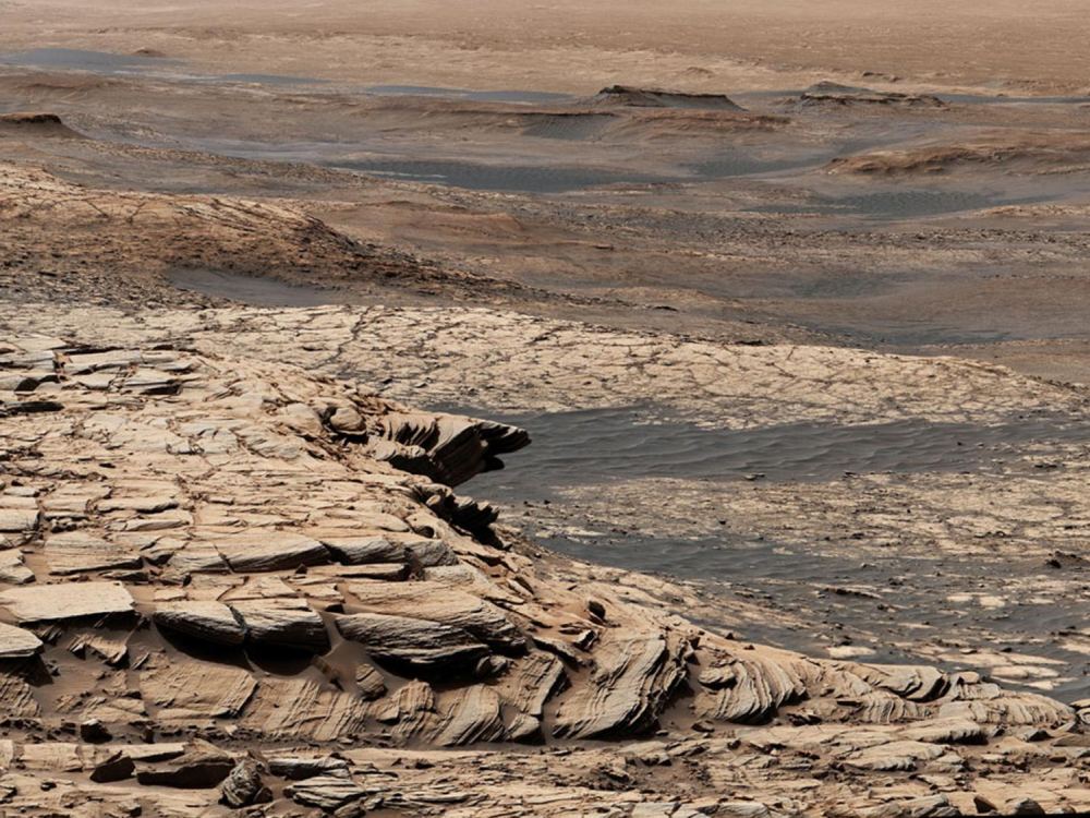
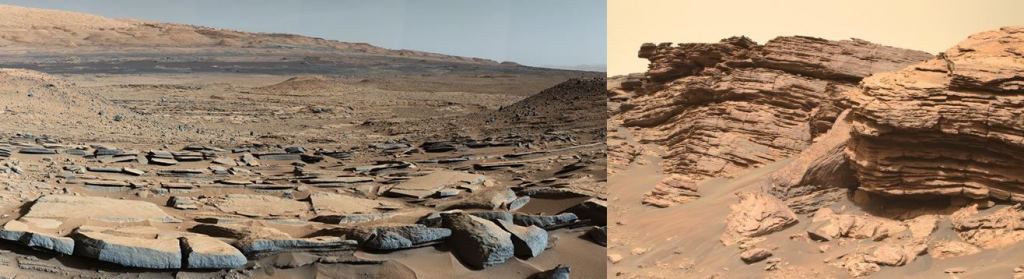
The map is focused on a region of Mars informally named Aeolis Dorsa. Aeolis Dorsa is a trough-like region in Mars' northern hemisphere that's about 500 km wide and 900 km long (300 miles wide and 560 miles long.) To the east and west of the region are plains 2 km (1.25 miles) high, named Zephyria Planum and Aeolis Planum. To the south are steep slopes that rise up to the southern hemisphere. The region is about 750 km east of Gale Crater, where MSL Curiosity is exploring.
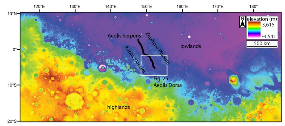
According to the authors, the Aeolis Dorsa region is the shoreline of an ancient ocean. The region contains more than 6,500 km (4,000 miles) of fluvial ridges and is Mars' most dense region of fluvial ridges. Fluvial ridges are elongated troughs carved by flowing water and are likely eroded river deltas or submarine-channel belts. The researchers used orbiter images of the region taken from different angles to reconstruct the topography. The topography revealed the presence of a 3.5 billion-year-old shoreline. There are sedimentary deposits over 900 meters (2950 feet) deep in the region that have since been eroded to different degrees.
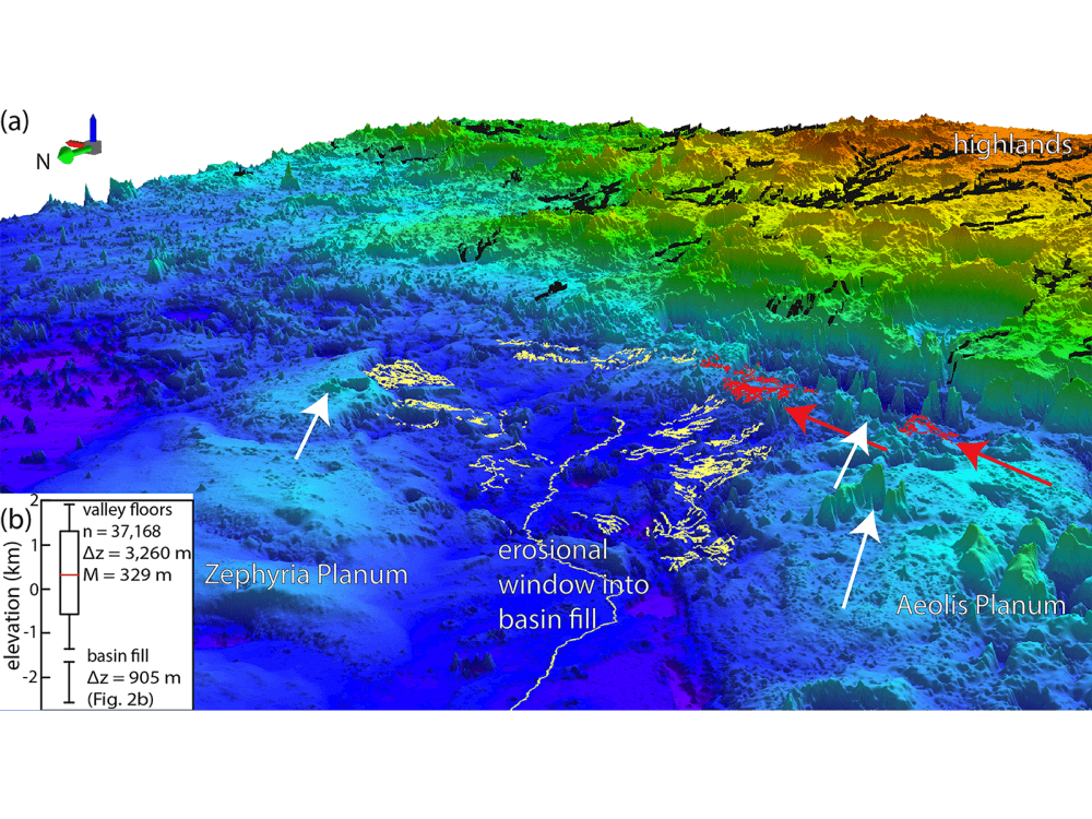
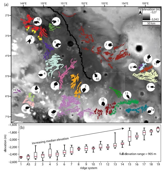
As part of their study, the authors organized Aeolis Dorsa's 6,500 km (4,000 miles) of fluvial ridges into 20 systems. As eroded remnants of river deltas or submarine-channel belts, they define the edges of the margin of the ancient ocean.
Aeolis Dorsa is a sedimentary basin, and scientists know from studying Earth how much geological information these basins hold. The basins contain a record of sediment deposits over geological time scales, which scientists refer to as 'stratigraphic succession.' On Earth, sedimentary basins also hold a lot of resources. Earth's coal, natural gas, and petroleum are found in these basins.
Mars won't have these resources, but the basins contain stratigraphic records of geological periods.
"The rocks in Aeolis Dorsa capture some fascinating information about what the ocean was like," said lead author Cardenas in a press release. "It was dynamic. The sea level rose significantly. Rocks were being deposited along its basins at a fast rate. There was a lot of change happening here."
Stratigraphy played a vital role in this research. Stratigraphy is the geological study of layers of rock. It's been around since 1669 when Catholic Priest Nicholas Steno established its theoretical groundwork. It's a critical component of understanding Earth's history; scientists use it to track changes in waterways over long periods. Stratigraphic records contain the record of Earth's changing climate and evolving life over time.
It only makes sense to look for sedimentary basins on Mars for clues on that planet's history. Water is critical in our quest to understand Mars and its ancient habitability. And stratigraphy is how researchers can understand how all that sediment built up over time as changing water levels caused the shoreline to advance and retreat.
"By grouping landforms based on stratigraphic position and paleoflow directions, we reconstructed
the paleogeography at Aeolis Dorsa over 5 timesteps; all cases differ from the modern topography," the authors explain in their paper. "We tracked the initial regression and later transgression of a shoreline during at least 900 m of sea-level rise, a scale consistent with a northern ocean on a warm and wet early Mars."
In a way, there's not much surprising or exotic about these findings. When water moves around on a planet's surface, this is the evidence it leaves behind. But this is Mars, and even a couple of decades ago, the Mars Ocean Hypothesis had a controversial side to it. There were naysayers when the Viking orbiters captured images of what looked like shorelines on Mars.
Viking found shorelines thousands of kilometres long, but orbital data from the Mars Global Surveyor found they rose and fell several kilometres in altitude. There's nothing like that on Earth, and skeptics pointed that out. Then a paper from 2007 showed that Mars' spin axis shifted by almost 3,000 km in the past 2 or 3 billion years. That could've accounted for the enormous changes in shoreline elevations on Mars.
This is where stratigraphy comes in. The stratigraphy in Aeolis Dorsa is very similar to Earth's; it just wasn't apparent decades ago.
"The stratigraphy that we're interpreting here is quite similar to stratigraphy on Earth," Cardenas said. "Yes, it sounds like a big claim to say we've discovered records of large waterways on Mars, but in reality, this is relatively mundane stratigraphy. It's textbook geology once you recognize it for what it is. The interesting part, of course, is it's on Mars."
Cells are the building blocks of living things, and they need liquid. Water provides pressure inside cells, which keeps everything inside the cell in the right shape. Without the proper form, the parts of the cell can't function properly, and there's no rigidity inside a cell. Without water, it's all over. In fact, cells are about 70% water by mass.
So the search for ancient life on Mars is intertwined with the search for ancient water. Since scientists think that shorelines on Earth were likely where life started, it makes sense to find shorelines on Mars as part of our search for ancient habitability. That's why NASA's Perseverance rover is exploring the sedimentary delta in Jezero Crater, and MSL Curiosity is exploring Gale Crater.
"A major goal for the Mars Curiosity rover missions is to look for signs of life," Cardenas said. "It's always been looking for water, for traces of habitable life. This is the biggest one yet. It's a giant body of water, fed by sediments coming from the highlands, presumably carrying nutrients. If there were tides on ancient Mars, they would have been here, gently bringing in and out water. This is exactly the type of place where ancient Martian life could have evolved."
