“Marstinis” Could Help Explain Why the Red Planet is So Small

Proof of Life on Mars
Mars. Credit: NASA Images

[/caption]

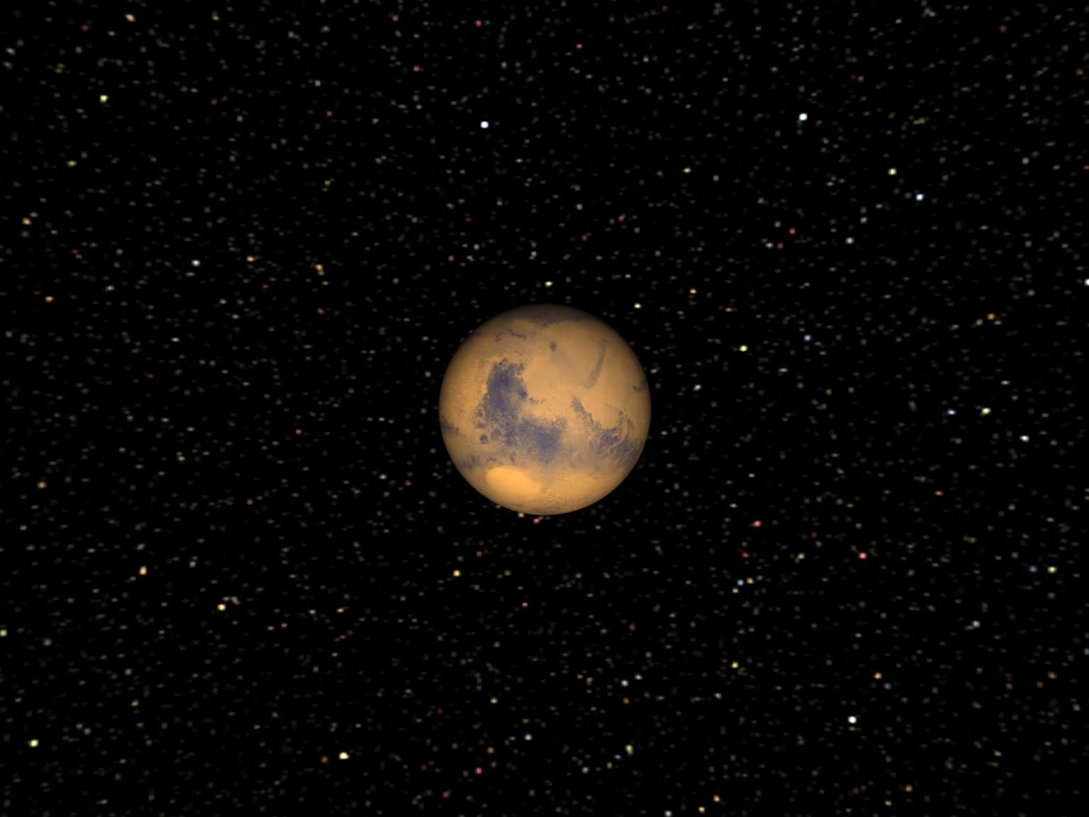
Mars is a small planet. In fact, for scientists who do solar system modeling, the planet is too small. “This is an outstanding problem in terrestrial planet formation,” said Dr. David Minton from the Southwest Research Institute. “Everyone who does simulations of how you form terrestrial planets always ends up with a Mars that is 5-10 times bigger than it is in real life.” Minton has been working alongside colleague Dr. Hal Levison to create new simulations that explain the small size of Mars by including the effect of what is known as planetesimal-driven migration, and additionally, small objects that Minton calls “Marstinis” could stir or shake up our ideas about the early solar system and the Late Heavy Bombardment.

Planetary scientists agree that the terrestrial planets formed very quickly within the first 50-100 million years of the solar system’s history and our Moon formed from an impact between a Mars-sized object and the proto-Earth at some point during that time. Much later was the Late Heavy Bombardment, the time period where a large number of impact craters formed on the Moon within a time span of only seventy million years — and by inference Earth, Mercury, Venus, and Mars were likely pummeled as well.

Most planetary formation theories can’t account for this intense period of bombardment so late in the solar system’s history, but Levison was part of a team that in 2005 proposed the Nice Model, which suggested how the Late Heavy Bombardment was triggered when the giant planets — which formed in a more compact configuration – rapidly migrated away from each other (and their orbital separations all increased), and a disk of small “planetesimals” that lay outside the orbits of the planets was destabilized, causing a sudden massive delivery of these planetesimals – asteroids and comets — to the inner solar system.

But, according to the model, planetesimals likely also caused the migration of the planets, too. The planets formed from a giant disk of gas, dust, rocky debris and ice surrounding the early Sun. Debris coalesced to form bigger planet-sized objects, and simulations shows that bigger planet-sized object embedded in a disk of smaller objects will migrate as a result of angular momentum and energy conservation as the planets scatter the planetesimals they encounter.

Artists concept of planetesimals and Jupiter.

“Perturbations from small rocky or icy objects surrounding a larger object can cause the larger object to ‘scoot’ along the disk,” Minton told Universe Today. “Every time these little planetesimals encounter the bigger object, they actually cause a little nudge in the position of the bigger object. It turns out if you work out the math, if there is any sort of slight imbalance to the number of objects encountering on the sunward side versus encountering on the anti-sunward side, you can actually cause a net movement of the big body, and it actually happens pretty quickly.”

Minton and Levison have been applying the same physics of planetesimal-driven migration to the formation of the terrestrial planets.

“In the case of Mars, imagine these planetary embryos located in the Earth-Venus zone,” Minton said. “Then you have a one little embryo growing to become Mars-sized, and it would start migrating because of planetesimal-driven migration, and it scoots away from the other guys. So it has left the pack, and as it moves through the disk, it gets stranded away from where all the action is going on.”

So Mars’ growth got stalled at its current size because it migrated away from the planet-building materials.

Minton said their simulations of this work really well.

“We’ve been doing a lot of math and the migration is pretty rapid,” he said, “and Mars could migrate through the disk before any other Mars-sized planet could form. In an early solar system where you have a Mars stranded off at the edge of the disk at 1.5 AU, which is where it is right now and all the other action going on in the Earth-Venus zone, then Earth and Venus were able to grow to the size they are now, where they are both roughly the same size and mass and Mars is stranded on its own.”

And with Mars there is a twist of Marstinis, which could offer an alternate explanation for the Late Heavy Bombardment.

The migrating Mars could have picked up planetesimals in its resonance, where two or more orbiting bodies exert a gravitational influence on each other.

“It is not at all obvious why that is,” Minton said, “but the same thing is thought to have happened in the outer solar system which is what gave Pluto its orbit. We think Pluto was actually picked up in the 3:2 resonance with Neptune when Neptune migrated out, and that’s why Pluto and the other “Plutinos” are living in these resonances with Neptune.”

The Plutinos are other Kuiper Belt objects near Pluto. That resonance means Pluto and the Plutinos go around the Sun three times for every 2 times Neptune does. There are also Two-tinos, which are caught in a 1:2 resonance with Neptune – and which are found towards the outer edge of the Kuiper belt. The new simulations show that these lines of resonances are almost like a snowplow, and as Neptune migrated out it picked up all these little icy bodies, Pluto and the Plutinos.

A graphic of the solar system in its current configuration; Mars is small. Credit: NASA

This also could have happened to Mars, and as Mars migrated through the disk it would have also picked up little objects.

“I’ve decided to calls these Marstinis, to keep in the Plutino and Two-tino, theme,” Minton said with a grin. “I don’t know if that will stick or not.”

But the interesting thing about the Marstinis, Minton said, is that a 3:2 resonance with Mars is actually a very unstable zone.

“There is actually a resonance there with Saturn that only existed in the time of the Late Heavy Bombardment,” he said, “so before that, Saturn — we think — was in a different position, so this particular resonance was in a different position. So it was only after the giant planets migrated to their current location that this resonance location became unstable. So we think that these Marstinis would have been stable and in that interim period between the end of planet formation and the Late Heavy Bombardment, all of a sudden this region became unstable when the planets shifted positions to their current locations.”

So could the Marstinis be responsible for the Late Heavy Bombardment?

“These Marstinis were pushed out from the planet forming regions out to the asteroid belt,” Minton said, “then all of a sudden the planets migrated and this whole region became unstable and so they all could have gone flinging into the inner solar system and end up hitting the Moon.”

Questions abound about the Late Heavy Bombardment.

There are a couple of other arguments, too where the Marstinis fit the profile of what hit the Moon during the Late Heavy Bombardment.

“We have reasons to think that the objects that hit the Moon during the Late Heavy Bombardment were sort of like asteroids but not exactly like the asteroids we have now,” Minton said. “So, there are some chemical arguments you can make, also you can make some arguments from the impact probabilities that may not have been enough mass in the asteroid belt to supply all the asteroids and impacts we see on the Moon.”
But there are other outstanding issues such as how long the Late Heavy Bombardment lasted, when it started, were comets ever important in the bombardment history of the Moon or was it all asteroids? Minton said further exploration of the Moon would answer many of these questions.

“These are all things that we really need to go to the Moon to find out and there is almost nowhere else you can go to do it. It really is one of the best places to go to understand all the solar system history.

Minton will present his findings at the upcoming Lunar and Planetary Science Conference in March, 2011.

You can listen to an interview I did with Minton about planetesimal-driven migration for the NASA Lunar Science Institute podcast (also available on the 365 Days of Astronomy.)

Martian Meteorite Reveals Ancient Water Flows, Methane

A view of the interior of a meteorite from Mars shows a vein through which water has flowed. Credit: University of Leicester

[/caption]

Scientists say a close-up look inside rare meteorite fragments from Mars shows evidence that impacts created flowing water near the surface of the Red Planet. At look at five different meteorite samples, including what is thought the be one of the very first Martian meteorite ever found on Earth, shows veins resulting from the impact and serpentine mineralization, which is associated with the production of methane.

PhD student Hitesh Changela and Dr. John Bridges from the University of Leicester used electron microscopes to study the structure and composition of five nakhlite meteorites, including one that was found in 1911 in El-Nakhla in Egypt (the meteorites were named after the location in which they were found). The meteorites had been housed in Natural History Museum, London, and the scientists sliced minute slivers of rock from the samples, about 0.1 microns thick.

By comparing the five meteorites, they showed the presence of veins created during an impact on Mars. Changela and Bridges suggest that this impact was associated with a 1-10 km diameter impact crater, and buried ice melted during this impact, creating flowing water which then deposited clay, serpentine minerals, carbonate and a gel deposit in the veins.

The scientists say their findings tie in with the recent water-related geological discoveries of clay and carbonate on the surface of Mars made by NASA and ESA orbiting spacecraft and the Mars Exploration rovers.

Nanometre scale atomic lattice spacings (measured by high resolution TEM) in serpentine. Credit: University of Leicester

“We are now starting to build a realistic model for how water deposited minerals formed on Mars,” said Bridges, “showing that impact heating was an important process. The constraints we are establishing about temperature, pH and duration of the hydrothermal action help us to better understand the evolution of the Mars surface. This directly ties in with the current activities of landing site selection for Mars rovers and Mars Sample Return. With models like this we will better understand the areas where we think that water was once present on Mars.”

Since serpentine mineralization is associated with the production of methane, the scientists say further research on the meteorites could help show how the methane was produced. A mission heading to Mars in 2016, the Trace Gas Orbiter, will help search for and understand the origin of any methane — a potential biomarker — in Mars’ atmosphere.

Findings from the research have been published in Meteoritics and Planetary Science (Dec. 2010 issue, vol 45).

Souce: University of Leicester

Spots Among Spots on Mars

A spotted landscape on Mars. Credit: NASA/JPL/U of AZ

[/caption]

This unusual landscape on Mars can be found within a crater on the southern hemisphere of the Red Planet. But if you look on the actual location of this HiRISE image on the Google Map of Mars, below, you’ll see these spots are just spots among spots.

An area of heavy cratering on Mars. Credit: Google Maps (Mars)

Seasonal spots appear on dunes found on the floors of craters on Mars; most likely it is from carbon dioxide frost that is “defrosting” and later may sublimate away. At one time, these spots that seemingly come and go with the seasons were thought to be signs of life on Mars. The jury is still out on that line of thinking.

See the original picture on the HiRISE website and zoom around the Google Mars (below the image on the HiRISE site) to see the entire area, or go to Google Mars.

All-Student Crew Lands at Mars Research Station

The all-student crew 99 at the Mars Desert Research Station. Credit: MDRS

[/caption]

Headline from the future? Actually, it’s happening now, although not quite on Mars, but about as close as humans can currently get. Six college students are the latest crew to embark on a two-week stint at the Mars Desert Research Station, a simulated Mars habitat set up by the Mars Society located in the San Rafael Swell of Utah. Looking across the very Mars-like red, rocky, panoramic vistas outside the habitat, participants might think they are on the Red Planet. And this latest crew, the 99th for MDRS, will be testing a microbial detection system and an EVA optimization method using an iPad.

The MDRS Campus in Utah, with the Habitat, observatory and greenhab.

The students — all graduate students or about to be – are from different colleges but came together in the summer of 2010 at the NASA Academy at the Ames Research Center in California, a 10-week immersive research internship.

“At the NASA Academy, we worked on a group project called LAMBDA – the Life and Microbial Detection Apparatus,” participant Max Fagin, from Dartmouth University, told Universe Today. “We wanted to do some follow-up work, in looking at microbial fuel cells, which run off the metabolic activity of bacteria — technology that could be applied to sewage reclamation plants in order to generate power.”

Fagin said the technology has been around a while, but they are trying to adapt it to detect microbes in soil samples, similar to what the Viking mission did in the 1970’s.

“We put a sample into the device and based on the power that is generated you can determine whether that power is coming from microbial activity or organic activity,” Fagin said.

They finished the summer internship with a good theoretical analysis and a non-working prototype, but wanted to field test their research, as well as continue work on other individual projects.

Crew patch for Crew LAMBDA.

Donna Viola, a senior undergraduate at the University of Maryland, Baltimore County, had been on two crew rotations on the MDRS previously and suggested to her fellow NASA Academy team that they apply as a group to the MDRS where they could test LAMBDA in actual conditions, with actual soil samples in the field where there may be potentially extremophile forms of life to find.

The team was accepted and began their crew rotation at MDRS on January 29. They will be there until February 12, all the while in complete Mars simulation. Crew members must wear a space suit when going outside the Habitat; they eat only space-travel type food (along with vegetables grown on-site in a greenhouse); power is provided by batteries or a power generation system; and there is also a water recycling system.

Viola is the Commander, Heidi Beemer is the team geologist and Executive Commander, Kevin Newman is the Engineer, Andie Gilkey is the team scientist and Health and Safety Officer, Chief Biologist, Sukrit Ranjan is the team astronomer and Fagin is the EVA Engineer.

See the crew biographies.

14 students total were part of the NASA Ames Academy, and even though only 6 are at the MDRS, the rest are serving as ground and mission support.

The last six weeks the team has been updating the LAMBDA device and making it field worthy, integrating it with the control system, and testing it.

While at MDRS, the crew has a few other projects, such as working on a proposed combination EVA planner and EVA monitor that runs on an iPad. “It monitors the astronauts’ health, vital signs, how much energy they are consuming, whether they should speed up or slow down – it’s basically an EVA optimizer,” Fagin said.

The Musk Observatory located at the Mars Desert Research Station

They will also fly a payload on a high altitude balloon that tests the feasibility of using balloon borne payloads on Mars. “There are no FAA regulations on Mars, so on Mars you could build a weather station on a balloon – such as on a 10 km tether and reel it in and out to get very nice vertical cuts of the atmospheric profiles of wind velocity and direction and dust profiles,” Fagin explained. “And also you could do astronomy by launching a small telescope. But we can’t do the tether part because they are here on Earth so we’ll be using a balloon and have to retrieve it.” They will also be flying a generic meteorological payloads and doing astronomical projects at the observatory on site, the Musk Observatory, which has a 14-inch telescope.

During their stay, the crew is required to send daily reports and dispatches from the commander, engineers, crew scientists, and journalists through the MDRS website which provides updates on the status of science experiments, updates on crew health and morale, and on the habitat and how it is faring. There is also a live webcam of different parts of the station.

MDRS is the second research station to be built by the Mars Society. The first was the Arctic station (FMARS) on Devon Island, built in 2000. Stations to be built in Europe (European Mars Analog Research Station / Euro MARS) and Australia (Australia Mars Analog Research Station / MARS Oz) are currently in the planning stages.

The goal of these analog research stations is to develop key knowledge, field tactics and equipment needed to prepare for the human exploration of Mars, testing habitat design features and tools, and to assess crew selection protocols. Utah is much warmer than Mars, the desert location is optimal because of its Mars-like terrain and appearance.

Find out more information on participating in the MDRS.

The first dispatches from the LAMBDA crew report how they are getting acclimated to the habitat and the equipment, as well as preparing for doing their actual science research.

Fagin said without the NASA Academy at Ames, this group of students wouldn’t be together at the MDRS today.

“This grew out of everything we did at the NASA Academy,” he said. “Without those experiences we would have no idea how to approach the situation, wouldn’t understand the science or engineering that needs to go into such a project, and certainly wouldn’t have the team-working abilities to do this if we hadn’t developed them while we were at the NASA Academy.”

Learn more about the NASA Ames Academy.

Universe Today hopes to provide an update on the LAMBDA crew’s activities.

Ken Kremer on Today’s APOD

Opportunity at Santa Maria Crater Credit: Mars Exploration Rover Mission, NASA, JPL, Cornell; Image Processing: Marco Di Lorenzo, Kenneth Kremer

[/caption]

Congrats to Universe Today writer Ken Kremer and his image processing partner Marco Di Lorenzo for their handiwork being featured on today’s Astronomy Picture of the Day. It’s one of their great images they have enhanced of the Opportunity Rover peering into its current location at Santa Maria Crater on Mars. Check it out on APOD!

Groovin’ to the Latest Images from Mars

The folks from the HiRISE Camera on the Mars Reconnaissance Orbiter have put together a video with some groovin’ music of the latest images from the Red Planet, courtesy of HiRISE, the bestest camera in all of Marsdom. There’s an elliptical impact crater, giant gullies, sinuous ridges and a Swiss Cheese smiley face. No foolin’!

7 Years of Opportunity on Mars and a Science Bonanza

The Long Journey of Opportunity to Santa Maria Crater. This collage of three maps (left, top) and a new close up panoramic mosaic of Santa Maria crater on Sol 2464, Dec 29, 2010 (bottom right) shows the route traversed by the Opportunity Mars rover during her nearly 7 year long overland expedition across the Meridiani Planum region of Mars. Opportunity landed inside Eagle crater on Jan. 24, 2004 and has driven over 26 km (16 mi) since then. Opportunity arrived at the western rim of Santa Maria Crater on Dec. 16, 2010 on Sol 2451 and is driving around the edge in a counterclockwise direction on her way to the huge 22 km wide Endeavour crater which shows signatures of water bearing minerals. The rover is visible in top map taken from orbit by MRO spacecraft. The Panoramic Mosaic of Santa Maria Crater on Sol 2464 - at bottom right – was stitched together from raw images taken by Opportunity’s navigation camera. The rover was about 5 meters from the rim and nearing water bearing materials located roughly at the right of this photomosaic. Credit: NASA/JPL/Cornell Marco Di Lorenzo, Kenneth Kremer

[/caption]

Today, Jan. 24, 2011 marks the 7th anniversary of the safe landing of the Opportunity Mars Exploration Rover (MER). Opportunity will soon celebrate another remarkable milestone – 2500 Sols, or Martian days, roving the red planet. Together with her twin sister Spirit, the NASA rovers surely rank as one of the greatest feats in the annals of space exploration.

“No one expected Spirit or Opportunity to go on this long,” says Ray Arvidson in an interview from Washington University in St. Louis. Arvidson is the deputy principal investigator for the Spirit and Opportunity rovers.

7 Years ago today on Jan. 24, 2004, NASA’s Opportunity rover daringly smashed into the Martian atmosphere at about 12,000 MPH on a one shot, do or die mission with no certainty as to the outcome. Thus began “The Six Minutes of Terror” as the plummeting probes heat shield endured temperatures exceeding 1400°C (2600 F) during the fiery entry, descent and landing phase (EDL).

The spectacular plunge was slowed by atmospheric friction on the heat shield and a complex pre-programmed combination of parachutes and retro rockets, and in the last moments by inflatable airbags designed to allow the robot to bounce about two dozen times and gently and gradually roll to a complete stop.

A Geologist's Treasure Trove at Eagle Crater. Jan 28, 2004.
This high-resolution image captured by the Mars Exploration Rover Opportunity's panoramic camera on Sol 3 highlights the puzzling rock outcropping that scientists were eagerly planning to investigate after safely landing. Opportunity was on its lander facing northeast; the outcropping lies to the northwest. These layered rocks measure only 10 centimeters (4 inches) tall and are thought to be either volcanic ash deposits or sediments carried by water or wind. Data from the panoramic camera's near-infrared, blue and green filters were combined to create this approximate, true-color image. Image credit: NASA/JPL/Cornell

Ultimately, Opportunity survived intact just like her twin sister Spirit who landed safely three weeks earlier on Jan. 3, 2004. EDL was the culmination of a seven month interplanetary cruise of over 250 million miles from Earth. Both rovers were launched from Cape Canaveral, Florida in the summer of 2003 on board Delta 2 rockets. The dynamic duo landed on opposite sides of the Red planet.

Opportunity is now 84 months into the 3 month mission – still alive and blazing a trail of Exploration and Discovery across the Meridiani Planum region of Mars.

The amazing Martian robot has driven more than 16.5 miles (26.7 km) and snapped over 148,000 pictures. She has suffered remarkable few mechanical failures and they have only minimally impaired her ability to traverse across the surface and conduct science operations.

Both rovers survived far beyond the mere 3 month “warranty” proclaimed by NASA as the mission began with high hopes following the nail biting “Six Minutes of Terror”. At the time, team members and NASA officials hoped they might function a few months longer.

“The rovers are our priceless assets” says Steve Squyres, of Cornell University who is the Principal Scientific Investigator for the mission. Squyres and the entire rover team treat every day with a “sense of urgency” and as “a gift to science”.

A Hole in One. Jan. 24, 2004. Sol 1.
The interior of a crater surrounding the Mars Exploration Rover Opportunity at Meridiani Planum on Mars can be seen in this color image from the rover's panoramic camera. This is the darkest landing site ever visited by a spacecraft on Mars. The rim of the crater is approximately 10 meters (32 feet) from the rover. The crater is estimated to be 20 meters (65 feet) in diameter. Scientists are intrigued by the abundance of rock outcrops dispersed throughout the crater, as well as the crater's soil, which appears to be a mixture of coarse gray grains and fine reddish grains. Data taken from the camera's near-infrared, green and blue filters were combined to create this approximate true color picture, taken on the first day of Opportunity's journey. The view is to the west-southwest of the rover. Credit: NASA/JPL/Cornell

Since 2004, the rover’s longevity has surpassed all expectations and nobody on the science and engineering teams that built and operate the twins can believe they lasted so long and produced so much science.

“We have a new Opportunity overview article publishing shortly in the Journal of Geophysical Research (JGR). The Spirit overview paper appeared recently. In addition, there will be about 24 new scientific papers coming out in the new few months as JGR special issues covering more of the MER results. ”

The incredible longevity is “way beyond the wildest expectations of even the people who built the twin sisters” according to fellow Cornell University Professor Jim Bell. “To say the rovers have surpassed expectations is an understatement. We’ve blown them out of the water”. Bell is the lead scientist responsible for the rovers’ high resolution color imaging system called Pancam.

“After 7 years it is still very exciting,“ Arvidson told me. “I am delighted to come to work every day. It’s great to work on the engineering plan for driving and operating the rovers and then see the results the next day.”

Spirit and Opportunity have accomplished a remarkable series of scientific breakthroughs, far surpassing the wildest dreams of all the researchers and NASA officials. Indeed both Mars rovers are currently stationed at scientific goldmines.

Opportunity is currently exploring the outskirts of the stadium sized ‘Santa Maria’ Carter – some 295 feet wide (90 m) – which holds deposits of water bearing minerals that will further elucidate the potential for habitability on the red planet.

The rover arrived at the western edge of the relatively fresh impact crater on Dec. 16, 2010 (Sol 2451). This intermediate stop on the rovers 19 km long journey from Victoria Crater to giant 22 km wide Endeavour Crater will provide important ground truth observations to compare with the orbital detection of exposures of hydrated sulfate minerals. Read more on Santa Maria in the next feature story.

Santa Maria is just 6 km from the western rim of Endeavour which shows spectral signatures of phyllosilicates, or clay bearing minerals, which formed in water about 4 billion years ago and have never before been directly analyzed on the Martian surface.

Phyllosilicates form in neutral aqueous conditions that could have been more habitable and conducive to the formation of life than the later Martian episodes of more harshly acidic conditions in which the sulfates formed that Opportunity has already been exploring during her 7 year long overland expedition.

Since the moment she landed inside ‘Eagle’ crater, Opportunity has been on a Martian crater tour her entire lifetime.

Opportunity “scored a 300-million mile interplanetary hole in one,” Steve Squyres said at that time, by improbably rolling to a stop smack inside the small 66 foot wide ‘Eagle’ crater (see map) after bouncing across the virtually flat and featureless dusty plains of Meridiani. She has been a lucky princess from the moment of her birth, spying layered sedimentary rocks in a bedrock outcrop from first light in her cameras a mere 26 feet or so away. That’s unlike any previous lander.

Eagle-eye View of 'Eagle Crater'. March 2004. This image shows the Mars Exploration Rover Opportunity's view on its 56th sol on Mars, before it left its landing-site crater. To the right, the rover tracks are visible at the original spot where the rover attempted unsuccessfully to exit the crater. After a one-sol delay, Opportunity took another route to the plains of Meridiani Planum. This image was taken by the rover's navigation camera. Image credit: NASA/JPL

Seven days later she drove off the landing pad, drilled into the outcrops and collected the “ground truth” science data to prove that hematite was present and liquid water had indeed flowed at Meridiani as a lake or shallow sea on ancient Mars.

After completing her science campaign, she climbed up and over the rim, departed ‘Eagle’ and arrived at ‘Endurance’ about 3 months after landing day.

After numerous tests, Opportunity was commanded to slowly crawl down into the crater. She gradually descending about 30 vertical feet, frequently drilling into the sedimentary rocks and layers to reveal Mars watery past in unprecedented scientific detail for about six months.

In Dec. 2004, Opportunity departed for “Victoria” crater, which many believed would be her final destination. The robot nearly perished in a sand trap at Purgatory along the way during a nearly two year drive across the treacherous martian sand dunes.

Opportunity arrived in Sept. 2006 to unveil Victoria’s Secrets in color. The rover actually wound up spending two years driving to different vantage points around the rim of and then inside the half mile wide crater before departing in Sept 2008 for the unimaginable goal of giant ‘Endeavour’ crater.

The rover team hopes to reach the slopes of Endeavour sometime later in 2011 if all goes well – before her 8th anniversary !

See below some of the best images taken by Opportunity during her 7 Year Martian Trek

Martian Moon Phobos eclipsing the sun on Sol 45
Ready to Enter Endurance.
This view looking was taken by the navigation camera on June 6, 2004. That was two sols before Opportunity entered the crater, taking the route nearly straight ahead in this image. This view is a cylindrical projection with geometric seam correction. Credit: NASA/JPL
Wopmay in False Color .
NASA's Mars Exploration Rover Opportunity examined a boulder called Wopmay before heading further east inside Endurance Crater. The frames combined into this false-color view were taken by Opportunity's panoramic camera during the rover's 251st martian day (Oct. 7, 2004). The coloring accentuates iron-rich spherical concretions as bluish dots embedded in the rock and on the ground around it. The rock is about one meter (3 feet) across. Credit: NASA/JPL/Cornell
Burns Cliff.
Opportunity captured this view of Burns Cliff after driving right to the base of this southeastern portion of the inner wall of Endurance Crater. The view combines frames taken by Opportunity's panoramic camera between the rover's 287th and 294th martian days (Nov. 13 to 20, 2004). The mosaic spans more than 180 degrees side to side. Because of this wide-angle view, the cliff walls appear to bulge out toward the camera. In reality the walls form a gently curving, continuous surface. Image credit: NASA/JPL/Cornell
Opportunity's Heat Shield in Color, Sol 335.
This image from the panoramic camera on NASA's Mars Exploration Rover Opportunity features the remains of the heat shield that protected the rover from temperatures of up to 2,000 degrees Fahrenheit as it made its way through the martian atmosphere. This two-frame mosaic was taken on Sol 335 (Jan. 2, 2005). The view is of the main heat shield debris seen from approximately 10 meters (about 33 feet) away from it. Many rover-team engineers were taken aback when they realized the heat shield had inverted, or turned itself inside out. The height of the pictured debris is about 1.3 meters (about 4.3 feet). The original diameter was 2.65 meters (8.7 feet), though it has obviously been deformed. The Sun reflecting off of the aluminum structure accounts for the vertical blurs in the picture.
Iron Meteorite on Mars.
Opportunity finds an iron meteorite on Mars, the first meteorite of any type ever identified on another planet. The pitted, basketball-size object is mostly made of iron and nickel. Opportunity used its panoramic camera to take the images used in this approximately true-color composite on the Sol 339 (Jan. 6, 2005). Credit: NASA/JPL/Cornell
Opportunity at Crater's Cape Verde in October 2006.
This image from the High Resolution Imaging Science Experiment on NASA's Mars Reconnaissance Orbiter shows the Mars Exploration Rover Opportunity near the rim of Victoria Crater. Victoria is an impact crater about 800 meters (half a mile) in diameter at Meridiani Planum near the equator of Mars. Five days before this image was taken, Opportunity arrived at the rim of Victoria, after a drive of more than 9 kilometers (over 5 miles). It then drove to the position where it is seen in this image. This view is a portion of an image taken by the High Resolution Imaging Science Experiment (HiRISE) camera onboard the Mars Reconnaissance Orbiter spacecraft on Oct. 3, 2006. Credit: NASA/JPL/UA

Victoria’s Secret Revealed in Color.
This Opportunity panorama reveals 2,500 ft-wide, 230 ft-deep Victoria Crater from the lip at Duck Bay alcove. Geologic layers reveal the history of Martian water here. The panorama was taken about 8 feet from the crater rim on Sol 952 (28 Sept 2006) as the rover sat between two steep promontories, Cape Verde and Cabo Frio. This vista exposes a thick stack of geologic layers which revealed the hidden watery secrets of the Martian environment farther back in time than any other location visited previously by the rovers. One can see a ½ mile to the distant cliff walls of the crater, above a windswept dune field in the center. This mosaic was assembled from navcam images and featured in Aviation Week & Space Technology magazine and on the Astronomy Picture of the Day (APOD) on 2 Oct. 2006 in high resolution. Credit: NASA/JPL/Cornell, Bernhard Braun, Marco Di Lorenzo, Kenneth Kremer. http://antwrp.gsfc.nasa.gov/apod/ap061002.html
Astronomy Picture of the Day (APOD) on 2 Oct. 2006 in high resolution

Check out this spherical projection panorama of Opportunity descending inside Victoria Crater on Sol 1332. Credit: NASA/JPL/Cornell/Nasatech.net

Layers of Cape Verde in Victoria Crater.
This view of Victoria crater is looking north from Duck Bay towards the dramatic promontory called Cape Verde. The dramatic cliff of layered rocks is about 50 meters (about 165 feet) away from the rover and is about 6 meters (about 20 feet) tall. The taller promontory beyond that is about 100 meters (about 325 feet) away, and the vista beyond that extends away for more than 400 meters (about 1300 feet) into the distance. This is an approximately true color rendering of images taken by the panoramic camera (Pancam) on NASA's Mars Exploration Rover Opportunity during Sol 952 (Sept. 28, 2006) using the camera's 750-nanometer, 530-nanometer and 430-nanometer filters. Credit: NASA/JPL/Cornell
Opportunity Traverse Map, Eagle to Victoria.
NASA's Mars Exploration Rover Opportunity reached the rim of Victoria Crater on Sept. 28, 2006, Sol 952. Opportunity drove 9.28 kilometers (5.77 miles) in the explorations that took it from Eagle Crater, where it landed in January 2004, eastward to Endurance Crater, which it investigated for about half of 2004, then southward to Victoria.
Lyell Panorama inside Victoria Crater.
During four months prior to the fourth anniversary of its landing on Mars, Opportunity examined rocks inside an alcove called Duck Bay in the western portion of Victoria Crater. The main body of the crater appears in the upper right of this panorama, with the far side of the crater lying about 800 meters (half a mile) away. Bracketing that part of the view are two promontories on the crater's rim at either side of Duck Bay. They are Cape Verde, about 6 meters (20 feet) tall, on the left, and Cabo Frio, about 15 meters (50 feet) tall, on the right. This view combines many images taken by Opportunity's panoramic camera (Pancam) from the Sol 1,332 through 1,379. (Oct. 23 to Dec. 11, 2007).

Relive Opportunity’s landing:

New Looks at Phobos from Mars Express Flyby

Image of Phobos with a resolution of 8.2 m/pixel in orbit 8974. The ellipses marked the previously planned (red) and currently considered (blue) landing sites for the Russian Phobos-Grunt mission. Credits: ESA/DLR/FU Berlin (G. Neukum)

[/caption]

The Mars Express team released the images today from the close flyby the spacecraft made of Phobos on January 9. The images weren’t downloaded from Mars Express until Jan. 18, and then they were processed, so these are hot off the press. The team didn’t provide much explanation, but enjoy the images. There’s one 3-D view in the group, so grab your 3-D glasses.

Another view of Phobos from Mars Express. Credits: ESA/DLR/FU Berlin (G. Neukum)
A sequence of images from 5 different channels on the high resolution camera on Mars Express. Credits: ESA/DLR/FU Berlin (G. Neukum
3-D view of Phobos from Jan. 9, 2011. Credits: ESA/DLR/FU Berlin (G. Neukum)

Here’s the on 3-D view, and the team explained that due to the stereo viewing geometry during the flyby a small part of the moon’s edge is only visible for the right eye resulting in odd 3D-perception in this area. This part has been slightly adjusted for better viewing. Also, for the left eye at the left edge of the image four small data gaps have been interpolated.

Image of Phobos with a resolution of 8.2 m/pixel in orbit 8974. The ellipses marked the previously planned (red) and currently considered (blue) landing sites for the Russian Phobos-Grunt mission. Credits: ESA/DLR/FU Berlin (G. Neukum)

Source: ESA

Drop Test for Next Mars Rover’s Sky-Crane Landing System

One of the biggest unknowns for the Mars Science Lab — a.k.a Curiosity — is the landing system, called the Sky Crane, which has never been used before for a spacecraft landing on another planet. It is similar to a sky crane heavy-lift helicopter, and it works like this: after a parachute slows the rover’s descent toward Mars, a rocket-powered backpack will lower the rover on a tether during the final moments before landing. This method allows landing a very large, heavy rover on Mars (instead of the airbag landing systems of previous Mars rovers).

The MSL team conducted a drop test of the Sky Crane, and you can see how it worked in the video, above.
Continue reading “Drop Test for Next Mars Rover’s Sky-Crane Landing System”

NASA Redoubling Efforts to Contact Spirit

Spirit’s Last Picture Show - for now. Spirit’s final panoramic mosaic was taken on Sol 2175 in February 2010, a few weeks before entering hibernation mode in March 2010 just prior to the onset of her 4th winter on Mars. The Columbia Hills serve as a backdrop in this image. The rover is stalled in a sand trap called Troy adjacent to the Home Plate volcanic feature in Gusev Crater. Von Braun mound, left of center, was next driving target for science until Spirit became mired in sulfate rich soil - which indicates significant past flow of liquid water in this region of Mars. Credit: NASA/JPL/Cornell, Marco Di Lorenzo, Kenneth Kremer

[/caption]

No one is giving up hope for Spirit. Not Yet. And neither should you.

It’s too soon to turn out the lights. Indeed NASA is stepping up operational efforts to contact the plucky rover – More communications commands; more listening time; more frequencies. Spirit last communicated with mission controllers back on Earth on March 22, 2010. The rover entered hibernation mode – some nine months ago – as the available sunlight to power the life giving solar panels was diminishing. NASA hopes to reawaken Spirit from a long slumber and reignite her breakthrough campaign of exploration and discovery from a scientific goldmine on the surface of the red planet.

“The sun is still rising on Mars,” says Ray Arvidson in an interview from Washington University in St. Louis. Arvidson is the deputy principal investigator for the Spirit and Opportunity rovers.

“We will keep listening for many months if necessary,” Steve Squyres informed me. Squyres is the Principal Scientific Investigator for the Mars Exploration Rover mission.

Carbonate-Containing Martian Rocks, False Color.
Data from Spirit collected in late 2005 has confirmed that an outcrop called Comanche contains a mineral indicating that a past environment was wet and non-acidic, possibly favorable to life.
Spirit captured this view of the Comanche outcrop during Sol 689 on Mars (Dec. 11, 2005). The rover's Mössbauer spectrometer, miniature thermal emission spectrometer and alpha particle X-ray spectrometer each examined targets on Comanche.
About one-fourth of the composition of Comanche is magnesium iron carbonate. That concentration is 10 times higher than for any previously identified carbonate in a Martian rock. Carbonates originate in wet, near-neutral conditions, but dissolve in acid. The find at Comanche is the first unambiguous evidence from either Spirit or Opportunity for a past Martian environment that may have been more favorable to life than the wet but acidic conditions indicated by the rovers' earlier finds. Credit: NASA/JPL-Caltech/Cornell University

By the time of the last dispatch from Mars, Spirit had lasted for nearly six years of bonus mission time – during the extended mission phase – light years beyond the 3 month “warranty” proclaimed by NASA as the mission began back in January 2004.

At Spirit’s location in the southern hemisphere of Mars, Southern Summer has not yet arrived. Right now it’s mid Southern Spring and daylight hours are increasing. And Summer doesn’t even start until mid-March 2011. The question is whether Spirit’s unheated electronics components have endured the extremely harsh and frigidly cold conditions of her 4th winter on Mars – her coldest ever. At about -100 C … Imagine Antarctica !

“The amount of solar energy available for Spirit is still increasing every day for the next few months,” said Mars Exploration Rover Project Manager John Callas of NASA’s Jet Propulsion Laboratory (JPL) , Pasadena, Calif. “As long as that’s the case, we will do all we can to increase the chances of hearing from the rover again.”

“We’re stepping up our efforts to contact Spirit — doubling down on her, as it were,” tweeted JPL mars rover driver Scott Maxwell.

And all those negative stories you may have read about Spirit being “Still Stuck” … well they totally missed the point.

A topographical map showing where Spirit became mired in loose, sulfate rich soil at a depression called Scamander Crater, about 8 meters (26 feet) wide and 25 centimeters (10 inches) deep. The total relief indicated by the color differences is about half a meter (20 inches) from the higher ground (color coded red) to the lower ground (color coded black). The map covers an area 12 meters (39 feet) wide from west to east. North is to the top.From its embedded position, the rover used its robotic arm to examine the patch of bright soil it had exposed, called Ulysses. The map indicates that Spirit is situated with its left wheels within the crater and right wheels outside the crater. Credit: NASA/JPL-Caltech/Ohio State University

In the final Sols, or Martian days, before falling silent in March 2010, there was dramatic movement by Spirit. “During the last 9 drives, Spirit actually moved 34 cm. That’s pretty good for a stationary rover,” Arvidson said.

This movement came despite the loss of two of the rover’s six wheels and after many months of methodical testing in the “Mars sand box”. Engineers at JPL devised and tested numerous strategies in attempting to extricate Spirit from the sand trap of soft soil in which she became mired.

Because of the declining sun and available power, Spirit basically just ran out of time to try and completely escape from the sand trap. This left it unable to obtain a favorable tilt for solar energy during the rover’s fourth Martian winter, which began last May.

Many members of the rover team are hopeful that they can indeed “Free Spirit” if she awakens from her current hibernation mode.

“I have no idea whether we’ll hear from Spirit again or not… there’s simply no way to predict it,” Squyres told me. “We will keep listening for many months. All we can do is listen”

Even if we never hear from Spirit again, she has accomplished a remarkable series of scientific breakthroughs, far beyond the wildest dreams of the science and engineering teams that built and operate the twins.

Both rovers have made important discoveries about wet environments on ancient Mars that may have been favorable for supporting microbial life.

Spirit discovered a rock that contained high levels of carbonates, minerals that form in neutral watery conditions that are far more conducive to the formation of life than the acidic watery conditions reported earlier in the mission.

Although Spirit has been stalled at a place called ‘Troy’ since April 2009. she made a significant science discovery at that exact spot. Spirit examined the soil in great detail and found key evidence that water, perhaps as snow melt, trickled into the subsurface fairly recently and on a continuing basis.

While driving on the western edge of an eroded over volcanic feature named ‘Home Plate’, she unknowingly broke through a hard surface crust (perhaps 1 cm thick) and sank into hidden soft sand beneath. At ‘Troy’, Spirit discovered that the crust was comprised of water related sulfate materials and therefore found evidence for the past flow of liquid water on the surface of Mars – a great science discovery!

After mid-March, prospects for reviving Spirit would begin to drop, say NASA officials. Communication strategies would change based on reasoning that Spirit’s silence is due to factors beyond just a low-power condition. Mission-ending damage from the cold experienced by Spirit in the past Martian winter is a real possibility.

This mosaic of images shows the soil in front of NASA's Mars Exploration Rover Spirit after a series of short backward drives during attempts to extricate the rover from a sand trap in January and early February 2010. It is presented in false color to make some differences between materials easier to see. Bright-toned soil was freshly exposed by the rover's left-front wheel during the drives and can be seen with a sand wave shaping that resulted from the unseen wheel's action.

Spirit's panoramic camera (Pancam) took the component images during the period from the 2,163rd to 2,177th Martian days, or sols, of Spirit's mission on Mars (Feb. 2 to Feb. 16, 2010). The turret at the end of the rover's arm appears in two places because of movement during that period. Insets in the upper left and lower right corners of the frame show magnified views of the nearby inscribed rectangles within the mosaic. The patch of ground within each rectangle is about 25 centimeters (10 inches) across. The top inset and upper portion of the mosaic include targets within soil layers exposed by the action of Spirit's wheels in April 2009 and examined in detail with instruments on Spirit's arm during the five subsequent months.

Olive pit and Olive leaf are two of the analyzed targets. The investigations determined that, under a thin covering of windblown sand and dust, relatively insoluble minerals are concentrated near the surface and more-soluble ferric sulfates have higher concentrations below that layer. This pattern suggests water has moved downward through the soil, dissolving and carrying the ferric sulfates. The brightness and color of the freshly disturbed soil seen in the center area of the mosaic indicates the this formerly hidden material is sulfate-rich. Before Spirit drove into this patch, the surface looked like the undisturbed ground highlighted in the lower-right inset. Flecks of red material in the surface layer resemble the appearance of the surface layer at other locations where Spirit's wheels have exposed high-sulfate, bright soils. Image Credit: NASA/JPL-Caltech/Cornell University


Spirit entered a low-power fault mode in March 2010 with minimal activity except charging and heating the batteries and keeping its clock running. With most heaters shut off, Spirit’s internal temperatures dipped lower than ever before on Mars. That stress could have caused damage, such as impaired electrical connections, that would prevent reawakening or, even if Spirit returns to operation, would reduce its capabilities.

“Components within the rover electronic module (REM) inside the rover’s warm electronic box (WEB) are experiencing record low temperatures,” said Doug McCuistion, the director of Mars Exploration at NASA Headquarters in Washington, DC, in an interview about Spirit’s predicament. “The expectation is for the REM hardware to reach -55C at the coldest part of the winter. We have tested the REM down to -55C”.

NASA’s Deep Space Network of antennas in California, Spain and Australia has been listening for Spirit daily in coordination with the spacecraft orbiting Mars; Mars Odyssey and Mars Reconnaissance Orbiter. In X-band, the DSN listens for Spirit during one pass each day. The rover team has also been sending commands to elicit a response from the rover even if the rover has lost track of time.

Now, the monitoring is being increased. Additional listening periods include times when Spirit might mistake a signal from NASA’s Mars Reconnaissance Orbiter as a signal from Earth and respond to such a signal. Commands for a beep from Spirit will be sent at additional times to cover a wider range of times-of-day on Mars when Spirit might awaken.

“DSN does an average of 4 “sweep & beep” commands in each day’s pass,” according to JPL spokesman Guy Webster. Also, NASA is listening on a wider range of frequencies to cover more possibilities of temperature effects on Spirit’s radio systems

Opportunity is still blazing a trail of discovery on the opposite side of Mars. She is currently exploring the stadium sized Santa Maria Carter which holds deposits of water bearing minerals that will further elucidate the potential habitability on the red planet.

For current updates about Opportunity’s exciting view from the steep walled crater and while being simultaneously imaged from Mars orbit in exquisite high resolution, read my earlier stories.