Opportunity Rover Completes Exploration of fascinating Santa Maria Crater

Yuma Outlook at Santa Maria Crater on Sol 2476, Jan 10, 2011. Opportunity arrived at the hydrated mineral deposits located here at the southeast rim of the crater. Self portrait of Opportunity at left, casts shadow of rover deck and mast at right. Credit: NASA/JPL/Cornell, Marco Di Lorenzo, Kenneth Kremer High resolution version on APOD, Jan. 29, 2011 ; http://apod.nasa.gov/apod/ap110129.html

[/caption]

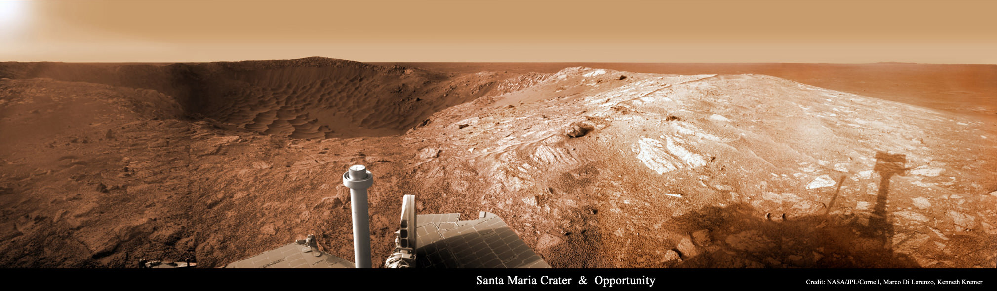
NASA’s long lived Opportunity Mars rover has completed a three month long exploration of Santa Maria crater along the trail towards its biggest target ever, Endeavour crater, some 22 kilometers in diameter. Santa Maria has simultaneously offered a series of stunning vistas and a scientific bonanza as a worthy way station in the rovers now seven year long overland expedition across the Martian plains of Meridiani Planum.

Opportunity made landfall at the western edge of Santa Maria on Dec. 15, 2010 (Sol 2450) after a long and arduous journey of some 19 kilometers since departing from Victoria Crater nearly two and one half years ago in September 2008. Santa Maria is the largest crater that the rover will encounter on the epic trek between Victoria and Endeavour.

Robotic arm at work on Mars on Sol 2513, Feb 17, 2011. Opportunity grinds into rock target Luis De Torres’ with the RAT. Credit: NASA/JPL/Cornell
The science team decided that Santa Maria would be the best location for an intermediate stop as well as permit a focused science investigation because of the detection of attractive deposits of hydrated minerals. The stadium sized and oval shaped crater is some 80 to 90 meters wide (295 feet) and about nine meters in depth.

Opportunity has since been carefully driven around the lip of the steep walled crater in a counterclockwise direction to reach the very interesting hydrated sulfates on the other side. The rover made several stops along the way to collect long baseline high resolution stereo images creating 3 D digital elevation maps and investigate several rocks in depth.

Opportunity was directed to Santa Maria based on data gathered from Mars orbit by the mineral mapping CRISM spectrometer – onboard the Mars Reconnaissance Orbiter (MRO) – which indicated the presence of exposures of water bearing sulfate deposits at the southeast rim of the crater.

Opportunity rover panoramic photomosaic near lip of Santa Maria Crater on Sol 2519, Feb. 23, 2011. Opportunity drove to exposed rock named Ruiz Garcia to investigate hydrated mineral deposits located here at southeast portion of crater. Credit: NASA/JPL/Cornell, Kenneth Kremer, Marco Di Lorenzo

“Santa Maria is a relatively fresh impact crater. It’s geologically very young, hardly eroded at all, and hard to date quantitatively,” said Ray Arvidson from Washington University in St. Louis. Arvidson is the deputy principal investigator for the Spirit and Opportunity rovers.

The rover had to take a pause anyway in its sojourn to Endeavour because of a restrictive period of solar conjunction. Conjunction is the period when the Sun is directly in between the Earth and Mars and results in a temporary period of communications disruptions and blackouts.

During conjunction – which lasted from Jan. 28 to Feb. 12 – the rover remained stationary. No commands were uplinked to Opportunity out of caution that a command transmission could be disrupted and potentially have an adverse effect.

Advantageously, the pause in movement also allows the researchers to do a long-integration assessment of the composition of a selected target which they might not otherwise have conducted.

By mid-January 2011, Opportunity had reached the location – dubbed ‘Yuma’ – at the southeast rim of the crater where water bearing sulfate deposits had been detected. A study of these minerals will help inform researchers about the potential for habitability at this location on the surface of Mars.

Opportunity at rim of Santa Maria crater as imaged from Mars orbit on March 1, 2011, Sol 2524.
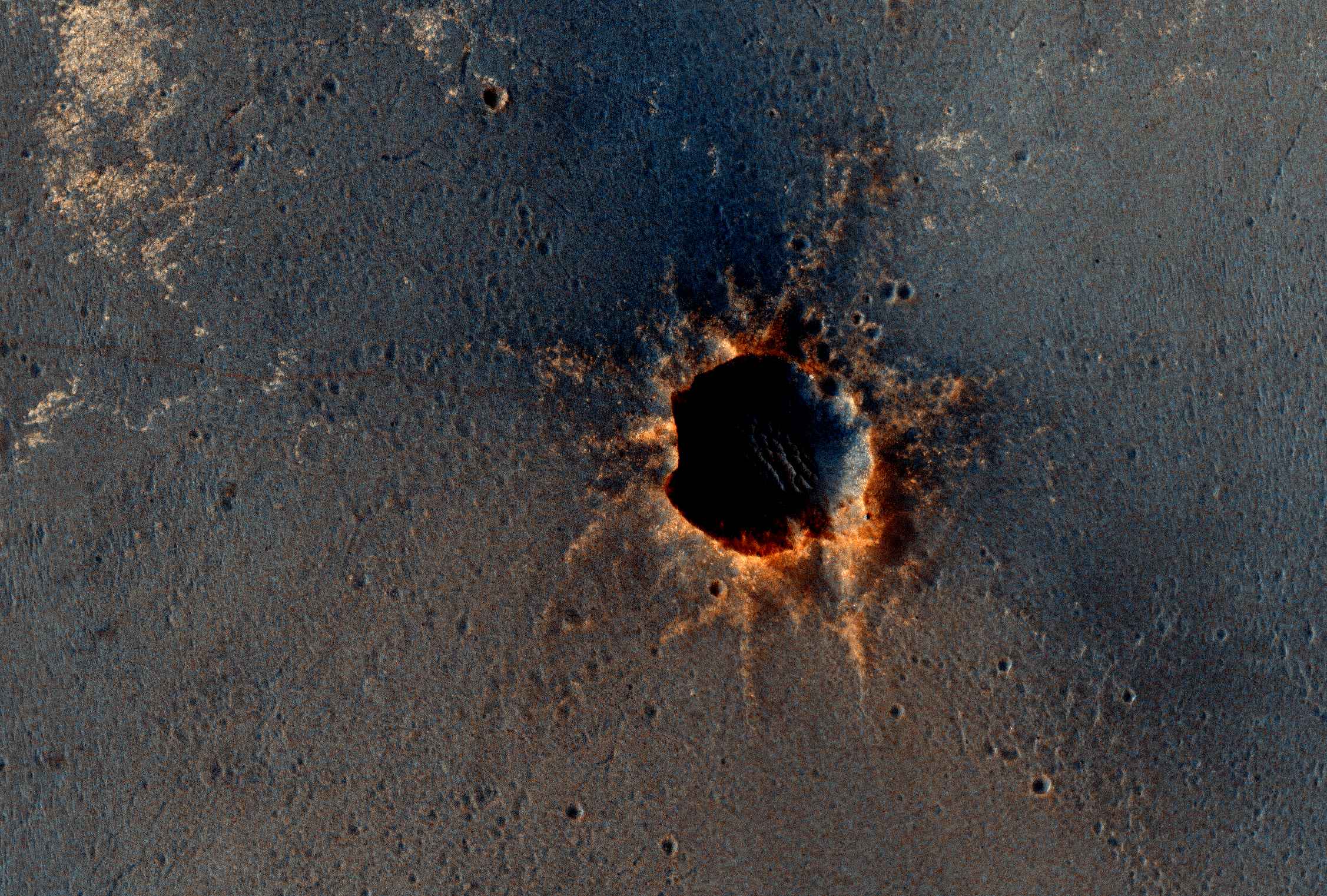
Rover was extending robotic arm to Ruiz Garcia rock as it was imaged by NASA’s MRO orbiter.
Credit: NASA/JPL-Caltech/Univ. of Arizona

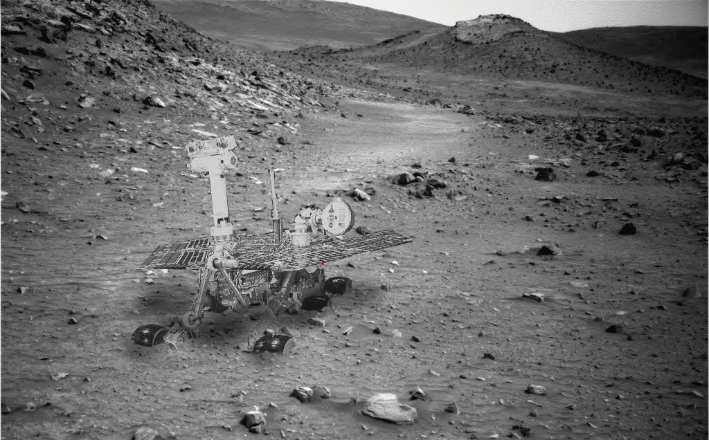
Opportunity snapped a collection of raw images from ‘Yuma’ which Marco Di Lorenzo and myself assembled into a panoramic photo mosaic (shown above) to illustrate the location. The high resolution version was selected to appear at Astronomy Picture of the Day on Jan. 29, 2011.

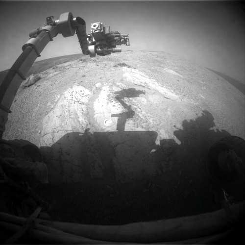
The rover turned a few degrees to achieve a better position for deploying Opportunity’s robotic arm, formally known as the instrument deployment device or IDD, to a target within reach of the arms science instruments.

“Opportunity is sitting at the southeast rim of Santa Maria,” Arvidson told me. “We used Opportunity’s Rock Abrasion Tool (RAT) to brush a selected target and the Moessbauer spectrometer was placed on the brushed outcrop. That spot was named ‘Luis De Torres’, said Arvidson.

Ruiz Garcia rock imaged by pancam camera on Sol 2419. Credit: NASA/JPL/Cornell
‘Luis De Torres’ was chosen based on the bright, extensive outcrop in the region in which CRISM sees evidence of a hydrated sulfate signature.”

Opportunity successfully analyzed ‘Luis De Torres’ with all the instruments located at the end of the robotic arm; including the Microscopic Imager (MI), the alpha particle X-ray spectrometer (APXS) and then the Moessbauer spectrometer (MB) for a multi-week integration of data collection.

After emerging in fine health from the conjunction, the rover performed a 3-millimeter deep grind on ‘Luis De Torres’ with the RAT in mid-February 2011 to learn more about the rocks interior composition. Opportunity then snapped a series of microscopic images and collected spectra with the APXS spectrometer.

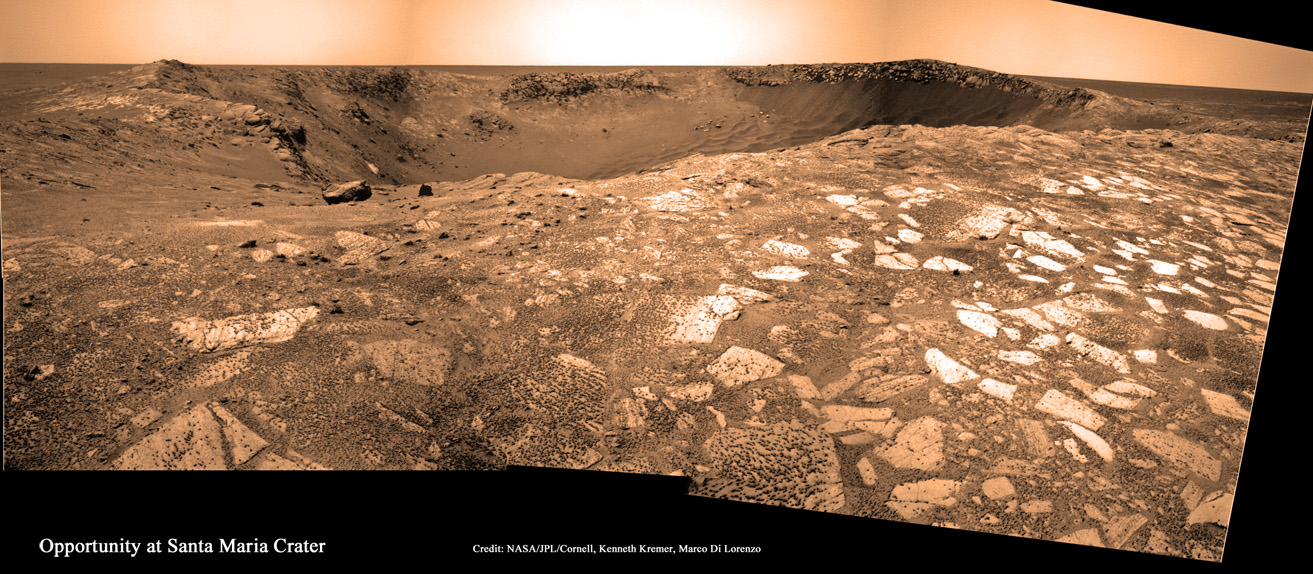
The rover then continued its counterclockwise path along the eastern edge of the crater, driving northwards some 30 meters along the crater rim to a new exposed rock target – informally named ‘Ruiz Garcia’ to collect more APXS spectra and microscopic images. See our mosaic showing “Ruiz Garcia” at the lip of the crater (above).

Opportunity finished up the exploration of the eastern side of Santa Maria in March by snapping a few more high resolution panoramas before resuming the drive to Endeavour crater which lies some 6.5 kilometers (4 miles) away.

Endeavour is Opportunity’s ultimate target in the trek across the Martian dunes because it possesses exposures of a hitherto unexplored type of even more ancient hydrated minerals, known as phyllosilicates, that form in neutral water more conducive to the formation of life.

Raw image from Opportunity's front hazard-avoidance camera on Sol 2524 ( March 1, 2011)
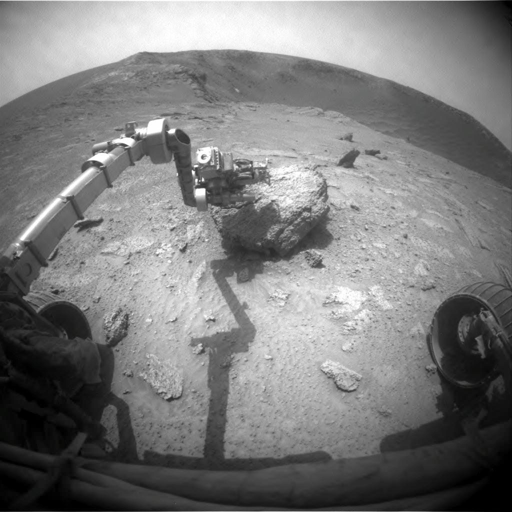
showing the robotic arm extended to Ruiz Garcia rock target. Credit: NASA/JPL/Cornell

Curiosity Rover Testing in Harsh Mars-like Environment

NASA’s Curiosity Rover inside a high vacuum environmental testing chamber at NASA's Jet Propulsion Laboratory. Engineers placed Curiosity inside the chamber to simulate the surface conditions on Mars that the rover will experience after landing in August 2012. Credit: NASA/JPL-Caltech

[/caption]

NASA’s next Mars rover, named Curiosity, is now undergoing crucial tests that are designed to simulate the harsh environmental conditions of the Martian surface that awaits the rover when she lands there in August 2012.

Curiosity, also known as the Mars Science Laboratory or MSL, is the size of a mini-Cooper. It was placed inside a 7.6 meter (25 foot) diameter high vacuum chamber at NASA’s Jet Propulsion Laboratory. Engineers are now conducting an extensive regimen of tests that will check out the performance and operational capabilities of the rover under Mars-like conditions.

Curiosity enters the 7.6-meter-diameter space-simulation chamber on March 8, 2011 at NASA's Jet Propulsion Laboratory, Pasadena, Calif. The rover is fully assembled with all primary flight hardware and instruments. The test chamber's door is still open in this photo. Credit: NASA/JPL-Caltech
Since the atmosphere of Mars is very thin – roughly 0.6% compared to Earth – most of the air was pumped out to simulate the meager atmospheric pressure on the surface of Mars.

The internal chamber temperature was decreased to minus 130 degrees Celsius (minus 202 degrees Fahrenheit) using liquid nitrogen flowing through the chamber walls to approximate the Antarctic like bone chilling cold. Martian lighting conditions are being simulated by a series of powerful lamps.

Upon successful completion of the testing, all components of the MSL spacecraft system will be shipped to the Kennedy Space Center for final integration. This includes the cruise stage, descent stage and back shell.

The launch window for MSL extends from Nov. 25 to Dec. 18, 2011 atop an Atlas V rocket from pad 41 at Cape Canaveral, Florida.

MSL will land using a new and innovative sky crane system instead of airbags. Using the helicopter-like sky crane permits the delivery of a heavier rover to Mars and with more weight devoted to the science payload. Indeed the weight of Curiosity’s science payload is ten times that of any prior Mars rover mission.

Artist's concept illustrates Mars rover Curiosity traversing across martian surface. Credit: NASA/JPL-Caltech

MSL also features a precision landing system to more accurately guide the rover to the desired target than past missions, to within an ellipse about 20 kilometers long. After extensive evaluation, four landing sites where water once flowed have been selected for further evaluation. The final decision will come sometime in 2011.

Curiosity is about twice the size and four times the weight compared to NASA’s Spirit and Opportunity Mars Explorations Rovers which landed on Mars back in 2004. Opportunity continues to stream back science data from Mars after seven years. The fate of Spirit is unknown at this time as the plucky rover has been out of contact since entering hibernation in March 2010.

The science goal of Curiosity is to search the landing site for clues about whether environmental conditions favorable for microbial life existed in the past or even today on Mars and whether evidence for life may have been preserved in the geological record.

The rover is being targeted to an area where it is believed that liquid water once flowed and may be habitable. In particular the science teams hope to sample and investigate phyllosilicate clays, which are minerals that form in neutral watery conditions more favorable to the formation of life compared to the more acidic environments investigated thus far by Spirit and Opportunity.

Engineers work on the six wheeled Curiosity rover in a clean room at NASA's Jet Propulsion Laboratory. Credit: NASA/JPL-Caltech

Hopes Dim for Contacting Spirit Rover

A composite image of how the Spirit rover probably looks, stuck in Gusev Crater. Credit: NASA, image editing by Stu Atkinson.

[/caption]

Still no response from Spirit, the Mars Exploration Rover that became stuck in a sand trap on the Red Planet, and went into hibernation without sufficient solar power. March 10 was the point at which the rover should have received its maximum amount of sunshine – i.e. power — for this Martian year, and with the passage of that date, optimism is dimming for being able to revive Spirit. But, the rover teams have not yet given up all hope and have a few unique strategies up their sleeves to try and wake the sleeping rover.

Over the past few months, engineers at JPL said they used strategies to contact Spirit based on the possibility that increasing energy availability might wake the rover from hibernation. Now, the team has switched to communication strategies designed to address more than one problem on the rover.

“The commands we are sending starting this week should work in a multiple-fault scenario where Spirit’s main transmitter is no longer working and the mission clock has lost track of time or drifted significantly,” said JPL’s John Callas, project manager for Spirit and Opportunity.

No one probably wants to hear this, but if no signal is heard from Spirit in the next month or two, the rover will officially be declared as lost, and the rover teams will shift to single-rover operations, continuing to operate Spirit’s active twin, Opportunity.

The Spirit rover, as seen by the HiRISE camera on the Mars Reconnaissance Orbiter. Credit: NASA, image enhanced by Stu Atkinson.

Spirit has not communicated for almost one Earth year — since March 22, 2010. Being stuck as the Martian winter approached, the rover could not move into a favorable position for its solar panels to gather enough energy from the Sun to keep the rover completely “alive,” and it eventually went into a low-power hibernation mode.

Officials from JPL said that during the Martian winter with most heaters turned off, Spirit experienced colder internal temperatures than in any of its three previous winters on Mars. The cold could have damaged any of several electronic components that, if damaged, would prevent reestablishing communication with Spirit.

But the rover teams have worked for more than 8 months to try and regain contact, just in case the increased solar power available would have awoken Spirit. NASA’s Deep Space Network of antennas in California, Spain and Australia has been listening for Spirit daily. The rover team has also sent commands to elicit a response from the rover even if the rover has lost track of time, or if its receiver has degraded in frequency response.

With the available solar energy at Spirit’s site estimated to peak on March 10, revised commanding then began March 15, including instructions for the rover to be receptive over UHF relay to hailing from the Mars orbiters for extended periods of time and to use a backup transmitter on the rover.

We’ll wait patiently, and hope to hear from Spirit.

She landed on Mars waaaay back on Jan. 4, 2004, for a mission originally designed to last for three months.

Spirit and Opportunity both have made important discoveries about wet environments on ancient Mars that may have been favorable for supporting microbial life. Opportunity landed three weeks after Spirit.

New Color Image Shows Opportunity Rover from Orbit

Visible from Mars orbit are tracks, to the left, and the Opportunity rover itself, sitting on the edge of Santa Maria Crater. Credit: NASA/JPL/University of Arizona

[/caption]

Another great shot by the HiRISE camera on the Mars Reconnaissance Orbiter: this one of the Opportunity rover sitting on the edge of Santa Maria Crater. The High Resolution Imaging Science Experiment took this image on March 1, 2011, and also visible are the tracks in the Martian soil that Oppy created as she made her way to the crater.

“Opportunity has been studying this relatively fresh 90-meter diameter crater to better understand how crater excavation occurred during the impact and how it has been modified by weathering and erosion since,” said Matt Golombeck, a research geologist at the Jet Propulsion Laboratory, and part of the rover team. “Note the surrounding bright blocks and rays of ejecta.”

You can see a non-annotated image here. March 1 on Earth is the 2,524th Martian day, or sol, of Opportunity’s work on Mars.

By the way, MRO celebrates its 5th anniversary of being in orbit of Mars on March 10. Wow, 5 years already? But its been 5 years of great images and discoveries, with wishes from all of us for many more!

Ken Kremer has put together a couple of collection of images that Opportunity has taken while at Santa Maria, some that he and others from Unmanned Spaceflight.com have processed and enhanced for sharper, colored views — this article contains several awesome panoramas, and here’s a collection of 3-D images.

Source: HiRISE website

Vast Areas of Low Latitude Subsurface Ice Found on Mars

Color image of a region in Holden Crater. Credit: NASA/JPL/University of Arizona

[/caption]

There could be more subsurface ice on Mars than previously thought, and vast stretches of it may lie just south of the equator. Indeed, one of the proposed landing sites for the Mars Science Laboratory could hold the mother lode of enticing scientific prospects. Observations from two spacecraft, the Mars Reconnaissance Orbiter and Mars Express, have revealed potential subsurface ice deposits in areas just south of the equator, including one near Holden Crater, with an estimated reservoir of perennial subsurface water ice of about 50 – 500 kg m -2 just two or three meters beneath the surface. This is the first evidence of ice at “tropical” latitudes on Mars as low as 25 degrees.


In 2009, MRO observations revealed water ice as low as 45 degrees North in a recent small impact crater, and permanent water ice at Mars’ poles is known to exist. But most robotic missions – and hopefully one day human missions – need to land closer to the equator to meet safety criteria and engineering constraints. As evidence, the four proposed landing sites for the MSL hover within 25 degrees of the equator.*

Of course, subsurface ice can’t be seen directly on Mars, but certain surface characteristics and thermal properties belie potential underground ice. The OMEGA (Observatoire pour la Minéralogie, l’Eau, les Glaces et l’Activité ) onboard Mars Express and CRISM (Compact Reconnaissance Imaging Spectrometer for Mars) onboard the Mars Reconnaissance Orbiter use near-infrared imaging spectrometers to measure solar radiation scattered by the surface, providing spectral images that have been used to assess the composition of both minerals and condensates on the surface of Mars.

What drew scientists to this region, were observed surface distributions of seasonal CO2 frost on pole facing slopes. Carbon dioxide ice usually only forms on the surface if there is a cold layer beneath, which can come from water ice or bedrock.

But in this case, Mathieu Vincendon and his team at Brown University concluded that bedrock couldn’t be responsible for creating the observed thermal properties that stores and releases heat two or three meters beneath the surface. Evidence of a uniform layer of bedrock stretching across the equatorial region has never been seen in orbital images, which would have been revealed by erosion or impact processes.

“Using different modeling hypotheses within the range of uncertainties leads to the result that water ice is present within one meter of the surface on all 20-30° pole facing slopes down to about 25°S,” the team writes in their paper. “ The relevant thermal depths probed are 2 or 3 meters. Hence, an ice rich layer that thick is implied, which leads to an estimated reservoir of perennial subsurface water ice of about 50 – 500 kg m -2 on steep slopes.”

The team believes that the subsurface ice could be possible remnants of the last ice age on Mars, and could provide water that will be needed for the future exploration of Mars. More thermal measurements of seasonal temperature variations could help to derive more precise permafrost depths.

Holden crater is located at the edge of the subsurface water ice area at 26°S.

*Eberswalde Crater is -23.90 degrees S, Mawrth Vallis is 23.99 degrees N, Gale crater is -4.49 degrees S, and Holden is -26.4 degrees S.

Sources: arxiv, Technology Review Blog

From Mars with Love on Valentines Day

A heart-shaped feature in the Arabia Terra region of Mars is show on the left, with additional context on the right, in excerpts of an image taken by the Context Camera on NASA's Mars Reconnaissance Orbiter. Image Credit: NASA/JPL-Caltech/MSSS

[/caption]

Happy Valentine’s Day from Mars to all the readers of Universe Today !

Well it’s truly a solar system wide Valentines celebration. From the Moon, Mars and even Comet Temple 1 with some pixie Stardust for the romantic rendezvous upcoming in a few short hours [Stardust-NExT Flyby at 11:37 p.m. EST Feb 14].

The Martian camera team from Malin Space Systems, San Diego, wishes to share a special heart-shaped feature from Arabia Terra – images above and below – with all Mars fans on this St. Valentine’s Day, Feb. 14, 2011. And certainly, I love Mars ! Especially those gorgeous and brainy twin gals Spirit & Opportunity.

Heart-shaped feature in Arabia Terra on Mars at 21.9 degrees north latitude, 12.7 degrees west longitude. Credit: NASA/JPL-Caltech/MSSS.
The image was taken on May 23, 2010 – at the start of northern summer on Mars – by the Malin-built and operated Context Camera on NASA’s Mars Reconnaissance Orbiter.

The bright heart shaped feature is about 1 kilometer (0.6 mile) long. Arabia Terra lies in the northern hemisphere of Mars

The tip of the heart lies above a small impact crater centered at 21.9 degrees north latitude, 12.7 degrees west longitude.

According to a JPL press release, “The crater is responsible for the formation of the bright, heart-shaped feature. When the impact occurred, darker material on the surface was blown away, and brighter material beneath it was revealed.

PIA13799: Heart-Shaped Feature in Arabia Terra (Wide View). Credit: NASA/JPL-Caltech/MSSS.
Some of this brighter material appears to have flowed further downslope to form the heart shape, as the small impact occurred on the blanket of material ejected from a much larger impact crater.

The Jet Propulsion Laboratory, Pasadena, Calif manages MRO for NASA.

More Martian hearts images below from another Malin built camera aboard NASA’s Mars Global Surveyor orbiter

Happy Valentines Day from Mars Global Surveyor (MGS)
This heart shaped pit on Mars is located on the east flank of the Alba Patera volcano in northern Tharsis. The pit was formed by collapse within a straight-walled trough known in geological terms as a graben. Graben are formed along fault lines by expansion of the bedrock terrain. Credit: NASA/JPL-Caltech/MSSS.
10 Martian Hearts for Valentine’s Day.
Mesas and depressions from all across Mars. Images taken by Mars Global Surveyor from 2001 to 2004. Credit: NASA/JPL-Caltech/MSSS.
Heart shaped landforms on Mars – or perhaps a box of chocolates !
Image taken by Mars Global Surveyor. Credit: NASA/JPL-Caltech/MSSS

Active Changes Occuring in Mars’ Northern Hemisphere

A time-series of black and white and false-color sub-images, from left to right at three sites in a field of transverse dunes at 84.7°N, 0.7°E shows that extensive erosion has taken place in one Mars year. Image courtesy of Science/AAAS.

[/caption]

Mars, it is a-changin’, and more than scientists expected. Several series of before-and-after images taken by the HiRISE camera on the Mars Reconnaissance Orbiter the past two years show sand dunes in Mars northern hemisphere changing – both gradually and suddenly. A team of researchers analyzing the images say that the changes have been caused mostly by sand and ice cascading down the slipfaces of the dunes. But, also, there could be “alien” processes that we don’t see occurring on Earth.

“The numbers and magnitude of the changes have been really surprising,” said HiRISE Deputy Principal Investigator Candice Hansen.

The white arrows point to a location on the brink of this dune at 84°N, 233°E that had no alcove in the first year of HiRISE operation (MY29) 
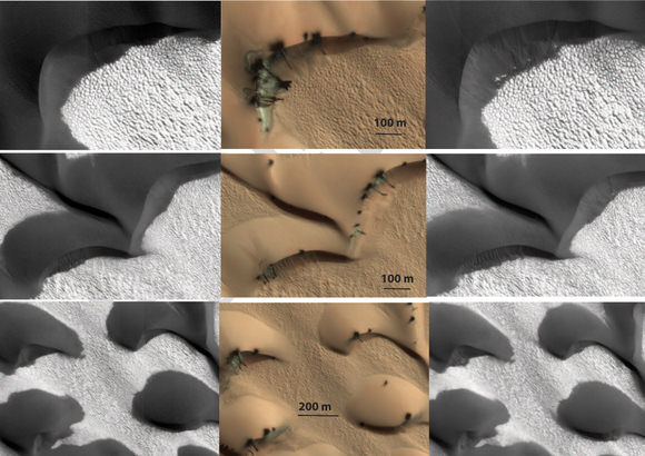
and experienced sublimation activity (middle), which resulted in the new alcove and fan (with total length of 120 m) in MY30. The layer of new material forming the apron is very thin; the original ripples have not been completely buried. Image courtesy Science/AAAS.

In the past, Mars was thought to be a dead world, frozen in time with not many changes taking place on its surface. But since the arrival of high-resolution cameras orbiting the Red Planet – first on the Mars Global Surveyor, and now on MRO and ESA’s Mars Express – that notion has fallen by the wayside. Avalanches, new gullies and now shifting sand dunes are appearing regularly on images from Mars.

Even with the known winds on Mars, scientists had considered the dunes to be fairly static, shaped long ago when winds on the planet’s surface were thought to be much stronger than they are today.

Hansen and her colleagues’ new paper that is published in this week’s edition of the journal Science identifies the seasonal changes from a layer of frozen carbon dioxide – a.k.a or dry ice – which covers the region in winter and sublimates away in the spring, along with stronger-than-expected gusts of wind as initiating sand transport on the northern dunes of Mars.

Three images of the same location taken at different times show seasonal activity causing sand avalanches and ripple changes on a Martian dune. Credit: NASA/JPL/The University of Arizona.

“This gas flow destabilizes the sand on Mars’ sand dunes, causing sand avalanches and creating new alcoves, gullies and sand aprons on Martian dunes,” Hansen said. “The level of erosion in just one Mars year was really astonishing. In some places hundreds of cubic yards of sand have avalanched down the face of the dunes.”

Recently, scientists have seen how the scars of past sand avalanches could be partially erased in just one Mars year. Models of Mars’ atmosphere do not predict wind speeds adequate to lift sand grains, and data from Mars landers such as Phoenix show high winds are a rare occurrence.

“Perhaps polar weather is more conducive to high wind speeds,” Hansen said.

The dune margin in MY29 image PSP_008968_2650 at 84.7°N, 0.7°E is compared with MY30 ESP_017895_2650. Image courtesy of Science/AAAS

The researchers say changes were seen in about 40 percent of far-northern monitoring locations over the two-Mars-year period of the study.

Related research with HiRISE previously identified gully-cutting activity in smaller fields of sand dunes covered by seasonal carbon-dioxide ice in Mars’ southern hemisphere. A report four months ago showed that those changes coincided with the time of year when ice builds up.

A false-color image of dark sand dunes at high northern latitudes on Mars that are covered seasonally by a layer of condensed carbon dioxide (dry ice), shown in this image. When the sun rises in the spring the ice begins to sublimate. Gas flow from the bottom of the ice layer propels sand from the dunes out through cracks to the top of the ice and down the dune slipface. Image courtesy of NASA/JPL/University of Arizona

“The role of the carbon-dioxide ice is getting clearer,” said Serina Diniega of NASA’s Jet Propulsion Laboratory, Pasadena, Calif., lead author of the earlier report and a co-author of the new report. “In the south, we saw before-and-after changes and connected the timing with the carbon-dioxide ice. In the north, we’re seeing more of the process of the seasonal changes and adding more evidence linking gully activity with the carbon dioxide.”

“Understanding how Mars is changing today is a key first step to understanding basic planetary processes and how Mars changes over time,” said HiRISE Principal Investigator Alfred McEwen, a co-author of both reports. “There’s lots of current activity in areas covered by seasonal carbon-dioxide frost, a process we don’t see on Earth. It’s important to understand the current effects of this unfamiliar process so we don’t falsely associate them with different conditions in the past.”

Source: Science

Simulated Mars Mission Arrives in Simulated Orbit

Mars500 crew just seconds before ingressing their module for a 520 day stay in June 2010. Credit: ESA

[/caption]

Six men from Europe, Russia and China on a 520-day mock mission to Mars, have now reached the point in their mission where they have arrived ‘in orbit’ of Mars. Mars500, the first full-duration simulation, is like a real Mars mission, where the crew has been in isolation, living and working like astronauts, eating special food and exercising the same way as crews aboard the International Space Station, and even experiencing lag time in communications. Now after 244 days of virtual interplanetary flight, the crew is getting ready to ‘land’ on Mars on February 12 where they will make three EVAs onto simulated Martian terrain.

Mars500 is not a just a flight of fancy or fantasy, but scientists from Russia and the European Space agency say it is a “pioneering international study of the complex psychological and technical issues that must be tackled for long spaceflights.”

Mars500 crew just seconds before ingressing their module for a 520 day stay in June 2010. Credit: ESA

The simulation has been running for more than eight months in hermetically sealed modules imitating a Mars spacecraft at the Institute of Biomedical Problems (IBMP) in Moscow.

“Mars500 is a visionary experiment,” said Simonetta Di Pippo, ESA Director for Human Spaceflight. “Europe is getting ready to make a step further in space exploration: our technology and our science grow stronger every day. Mars 500 today is only an enriching simulation, but we are working to make it real.”

The Mars500 facility has no windows, but a laptop running Celestia, a freeware space simulation software, acts as a virtual window as the crew approached the Red Planet. Credits: ESA

The crew has now opened a hatch between the mothership and the mockup of a lander that, according to script, was launched separately to Mars.

In the coming days, the cargo inside the ‘lander’ will be transferred into the habitat and the lander will be prepared for ‘undocking’ and ‘landing’.

The crew will then divide: Russian Alexandr Smoleevskiy, Italian Diego Urbina and Chinese Wang Yue will enter the lander, while the rest of the crew, Romain Charles from France and Sukhrob Kamolov and Alexey Sitev from Russia ‘remain in orbit’.

The hatch between the interplanetary spacecraft and lander will be closed on 8 February. The lander will undock and ‘touch down’ on Mars on 12 February.

The Mars terrain simulator of the Mars500 facility. The crew will drive a rover and place sensors during their sorties. Credits: IBMP/ Oleg Voloshin

The simulated Martian terrain is actually housed in a large hall alongside the Mars500 modules. The first EVA will take place on February 14, with subsequent sorties taking place on February 18 and 22.

Then the lander will return to orbit and dock with the mothership the following day.

The lander crew will stay in quarantine for three days before the hatch is opened on 27 February and the astronauts are reunited.

Mars500 participant Diego Urbina with a computer simulation in the Mars500 facility. Credits: ESA

After that, the crew is faced with another long, monotonous ‘interplanetary cruise’ before arriving home in early November 2011.

Source: ESA

“Marstinis” Could Help Explain Why the Red Planet is So Small

Proof of Life on Mars
Mars. Credit: NASA Images

[/caption]

Mars is a small planet. In fact, for scientists who do solar system modeling, the planet is too small. “This is an outstanding problem in terrestrial planet formation,” said Dr. David Minton from the Southwest Research Institute. “Everyone who does simulations of how you form terrestrial planets always ends up with a Mars that is 5-10 times bigger than it is in real life.” Minton has been working alongside colleague Dr. Hal Levison to create new simulations that explain the small size of Mars by including the effect of what is known as planetesimal-driven migration, and additionally, small objects that Minton calls “Marstinis” could stir or shake up our ideas about the early solar system and the Late Heavy Bombardment.

Planetary scientists agree that the terrestrial planets formed very quickly within the first 50-100 million years of the solar system’s history and our Moon formed from an impact between a Mars-sized object and the proto-Earth at some point during that time. Much later was the Late Heavy Bombardment, the time period where a large number of impact craters formed on the Moon within a time span of only seventy million years — and by inference Earth, Mercury, Venus, and Mars were likely pummeled as well.

Most planetary formation theories can’t account for this intense period of bombardment so late in the solar system’s history, but Levison was part of a team that in 2005 proposed the Nice Model, which suggested how the Late Heavy Bombardment was triggered when the giant planets — which formed in a more compact configuration – rapidly migrated away from each other (and their orbital separations all increased), and a disk of small “planetesimals” that lay outside the orbits of the planets was destabilized, causing a sudden massive delivery of these planetesimals – asteroids and comets — to the inner solar system.

But, according to the model, planetesimals likely also caused the migration of the planets, too. The planets formed from a giant disk of gas, dust, rocky debris and ice surrounding the early Sun. Debris coalesced to form bigger planet-sized objects, and simulations shows that bigger planet-sized object embedded in a disk of smaller objects will migrate as a result of angular momentum and energy conservation as the planets scatter the planetesimals they encounter.

Artists concept of planetesimals and Jupiter.

“Perturbations from small rocky or icy objects surrounding a larger object can cause the larger object to ‘scoot’ along the disk,” Minton told Universe Today. “Every time these little planetesimals encounter the bigger object, they actually cause a little nudge in the position of the bigger object. It turns out if you work out the math, if there is any sort of slight imbalance to the number of objects encountering on the sunward side versus encountering on the anti-sunward side, you can actually cause a net movement of the big body, and it actually happens pretty quickly.”

Minton and Levison have been applying the same physics of planetesimal-driven migration to the formation of the terrestrial planets.

“In the case of Mars, imagine these planetary embryos located in the Earth-Venus zone,” Minton said. “Then you have a one little embryo growing to become Mars-sized, and it would start migrating because of planetesimal-driven migration, and it scoots away from the other guys. So it has left the pack, and as it moves through the disk, it gets stranded away from where all the action is going on.”

So Mars’ growth got stalled at its current size because it migrated away from the planet-building materials.

Minton said their simulations of this work really well.

“We’ve been doing a lot of math and the migration is pretty rapid,” he said, “and Mars could migrate through the disk before any other Mars-sized planet could form. In an early solar system where you have a Mars stranded off at the edge of the disk at 1.5 AU, which is where it is right now and all the other action going on in the Earth-Venus zone, then Earth and Venus were able to grow to the size they are now, where they are both roughly the same size and mass and Mars is stranded on its own.”

And with Mars there is a twist of Marstinis, which could offer an alternate explanation for the Late Heavy Bombardment.

The migrating Mars could have picked up planetesimals in its resonance, where two or more orbiting bodies exert a gravitational influence on each other.

“It is not at all obvious why that is,” Minton said, “but the same thing is thought to have happened in the outer solar system which is what gave Pluto its orbit. We think Pluto was actually picked up in the 3:2 resonance with Neptune when Neptune migrated out, and that’s why Pluto and the other “Plutinos” are living in these resonances with Neptune.”

The Plutinos are other Kuiper Belt objects near Pluto. That resonance means Pluto and the Plutinos go around the Sun three times for every 2 times Neptune does. There are also Two-tinos, which are caught in a 1:2 resonance with Neptune – and which are found towards the outer edge of the Kuiper belt. The new simulations show that these lines of resonances are almost like a snowplow, and as Neptune migrated out it picked up all these little icy bodies, Pluto and the Plutinos.

A graphic of the solar system in its current configuration; Mars is small. Credit: NASA

This also could have happened to Mars, and as Mars migrated through the disk it would have also picked up little objects.

“I’ve decided to calls these Marstinis, to keep in the Plutino and Two-tino, theme,” Minton said with a grin. “I don’t know if that will stick or not.”

But the interesting thing about the Marstinis, Minton said, is that a 3:2 resonance with Mars is actually a very unstable zone.

“There is actually a resonance there with Saturn that only existed in the time of the Late Heavy Bombardment,” he said, “so before that, Saturn — we think — was in a different position, so this particular resonance was in a different position. So it was only after the giant planets migrated to their current location that this resonance location became unstable. So we think that these Marstinis would have been stable and in that interim period between the end of planet formation and the Late Heavy Bombardment, all of a sudden this region became unstable when the planets shifted positions to their current locations.”

So could the Marstinis be responsible for the Late Heavy Bombardment?

“These Marstinis were pushed out from the planet forming regions out to the asteroid belt,” Minton said, “then all of a sudden the planets migrated and this whole region became unstable and so they all could have gone flinging into the inner solar system and end up hitting the Moon.”

Questions abound about the Late Heavy Bombardment.

There are a couple of other arguments, too where the Marstinis fit the profile of what hit the Moon during the Late Heavy Bombardment.

“We have reasons to think that the objects that hit the Moon during the Late Heavy Bombardment were sort of like asteroids but not exactly like the asteroids we have now,” Minton said. “So, there are some chemical arguments you can make, also you can make some arguments from the impact probabilities that may not have been enough mass in the asteroid belt to supply all the asteroids and impacts we see on the Moon.”
But there are other outstanding issues such as how long the Late Heavy Bombardment lasted, when it started, were comets ever important in the bombardment history of the Moon or was it all asteroids? Minton said further exploration of the Moon would answer many of these questions.

“These are all things that we really need to go to the Moon to find out and there is almost nowhere else you can go to do it. It really is one of the best places to go to understand all the solar system history.

Minton will present his findings at the upcoming Lunar and Planetary Science Conference in March, 2011.

You can listen to an interview I did with Minton about planetesimal-driven migration for the NASA Lunar Science Institute podcast (also available on the 365 Days of Astronomy.)

Martian Meteorite Reveals Ancient Water Flows, Methane

A view of the interior of a meteorite from Mars shows a vein through which water has flowed. Credit: University of Leicester

[/caption]

Scientists say a close-up look inside rare meteorite fragments from Mars shows evidence that impacts created flowing water near the surface of the Red Planet. At look at five different meteorite samples, including what is thought the be one of the very first Martian meteorite ever found on Earth, shows veins resulting from the impact and serpentine mineralization, which is associated with the production of methane.

PhD student Hitesh Changela and Dr. John Bridges from the University of Leicester used electron microscopes to study the structure and composition of five nakhlite meteorites, including one that was found in 1911 in El-Nakhla in Egypt (the meteorites were named after the location in which they were found). The meteorites had been housed in Natural History Museum, London, and the scientists sliced minute slivers of rock from the samples, about 0.1 microns thick.

By comparing the five meteorites, they showed the presence of veins created during an impact on Mars. Changela and Bridges suggest that this impact was associated with a 1-10 km diameter impact crater, and buried ice melted during this impact, creating flowing water which then deposited clay, serpentine minerals, carbonate and a gel deposit in the veins.

The scientists say their findings tie in with the recent water-related geological discoveries of clay and carbonate on the surface of Mars made by NASA and ESA orbiting spacecraft and the Mars Exploration rovers.

Nanometre scale atomic lattice spacings (measured by high resolution TEM) in serpentine. Credit: University of Leicester

“We are now starting to build a realistic model for how water deposited minerals formed on Mars,” said Bridges, “showing that impact heating was an important process. The constraints we are establishing about temperature, pH and duration of the hydrothermal action help us to better understand the evolution of the Mars surface. This directly ties in with the current activities of landing site selection for Mars rovers and Mars Sample Return. With models like this we will better understand the areas where we think that water was once present on Mars.”

Since serpentine mineralization is associated with the production of methane, the scientists say further research on the meteorites could help show how the methane was produced. A mission heading to Mars in 2016, the Trace Gas Orbiter, will help search for and understand the origin of any methane — a potential biomarker — in Mars’ atmosphere.

Findings from the research have been published in Meteoritics and Planetary Science (Dec. 2010 issue, vol 45).

Souce: University of Leicester