
[/caption]
At 3,340 days and counting, NASA’s Mars Odyssey orbiter established a new record for longevity as of Dec. 15 and thereby worked longer at the red planet than any other spacecraft in human history.
The previous Martian record holder was the Mars Global Surveyor (MGS) orbiter which operated in orbit from Sept. 11, 1997 to Nov. 2, 2006 until contact was lost following a computer glitch.
Odyssey has made numerous high impact scientific discoveries along the way. The probe also relayed most of the science data from Spirit, Opportunity and Phoenix and will continue that task for NASA’s upcoming Mars Science Laboratory (MSL) rover named Curiosity.
The spacecrafts name – 2001 Mars Odyssey – was chosen as a tribute to the vision and spirit of space exploration as embodied in the works of renowned science fiction author Arthur C. Clarke – including the movie “2001: A Space Odyssey”.
It was way back on Oct. 24, 2001 that the Odyssey spacecraft fired its main engine to brake the crafts speed and allow it to be captured by Mars and enter a highly elliptical orbit. A technique known as aerobraking was used over the next three months to fly through the upper atmosphere and utilize drag to gradually lower the crafts altitude and eventually enter its mapping orbit.
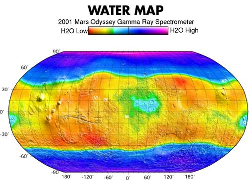
Science operations began in earnest in February 2002. Within a few months, Odyssey made the key discovery of the entire mission when it found that the polar regions harbored substantial caches of water ice within a meter of the dry surface of Mars.
The detection of water – in the form of hydrogen — from orbit using the crafts Gamma Ray Spectrometer led directly to the proposal for the Phoenix mission which confirmed the discovery in 2008. Phoenix landed directly on top of vast sheets of frozen water ice in the northern polar region of Mars and scooped up samples of ice for analysis by the landers science suite.
Another notable achievement by Odyssey during the primary mission phase was to complete a survey of the radiation environment to determine the radiation-related risk to any future human explorers who may one day go to Mars.
In another first, Odyssey’s instruments globally mapped the amount and distribution of many chemical elements and minerals that make up the martian surface. Such data helps explain how the planet’s landforms developed over time, provides clues to the geological and climatic history of Mars, informs about the potential for finding past or present life and where are the best locations to search for life and send future landers such as the Curiosity rover set to launch in November 2011.
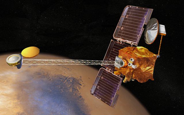
Mars Odyssey is equipped with three primary science instruments to accomplish the goals set out in NASA Mars Exploration Program:
• THEMIS (Thermal Emission Imaging System), for determining the distribution of minerals, particularly those that can only form in the presence of water;
• GRS (Gamma Ray Spectrometer), for determining the presence of 20 chemical elements on the surface of Mars, including hydrogen in the shallow subsurface (which acts as a proxy for determining the amount and distribution of possible water ice on the planet); and,
• MARIE (Mars Radiation Environment Experiment), for studying the radiation environment.
The primary mission lasted until August 2004. Since then the mission lifetime has been extended several times and further extensions are in the works according to Guy Webster, the Public Affairs Officer at NASA’s Jet Propulsion Laboratory (JPL) in Pasadena, Calif., which manages the Odyssey mission.
“We are currently in the fourth extended mission which is funded through the end of September 2012,” Webster told me. “Extended missions are funded for about a one-Mars-year period, which is approximately equal to two years. The next extended mission period will be during the MSL’s prime surface mission and Odyssey is an integral part of the effort to relay MSL’s data from the surface and back to Earth.”
MSL is slated for an August 2012 landing on Mars. “It is expected that Odyssey will be approved for a fifth extended mission,” said Webster.
“The total investment in this mission so far — including development, assembly & test, launch, and operations — is $508 million,” added Webster.

A huge bonus of scientific accomplishments has been enabled during the extended mission phase that otherwise would not have been possible.
“The extra years have allowed us to build up the highest-resolution maps covering virtually the entire planet,” said Odyssey Project Scientist Jeffrey Plaut of JPL.
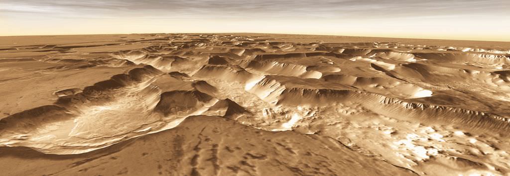
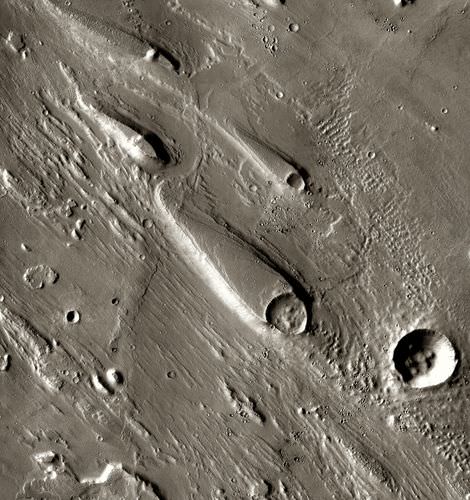
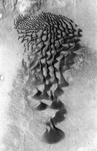
The maps were constructed using nearly 21,000 images taken by the THEMIS camera which was built and is operated by Arizona State University, Tempe. Surface details as small as 100 meters (330 feet) wide are visible. Check out this slide show of some of Odyssey’s greatest hits as compiled by the camera team and NASA: http://www.nasa.gov/mission_pages/odyssey/images/all-stars.html

The ability to monitor seasonal changes on Mars from year-to-year, such as the cycle of carbon-dioxide freezing out of the atmosphere in polar regions during each hemisphere’s winter, is another example of bonus science from the extended mission.
“It is remarkable how consistent the patterns have been from year to year, and that’s a comparison that wouldn’t have been possible without our mission extensions,” Plaut said.
The science team comprises numerous additional partners including the Russian Aviation and Space Agency, the University of Arizona, and Los Alamos National Laboratory.
Odyssey has served as the primary means of communications for NASA’s Mars surface explorers in the past decade and will continue that role for the upcoming Curiosity rover.
“More than 95 percent of the data from Spirit and Opportunity and approximately 79 percent of the data from Phoenix was relayed by Odyssey,” Webster stated.
Given the propellant reserves on board, Odyssey could continue operating until at least about 2016 and perhaps even well beyond if the ships systems remain healthy.
“21.6 kg of propellant remains with an average consumption rate of about 1.4 kg per year,” according to Webster. “However, there are other elements of the spacecraft that might suggest that Odyssey’s life expectancy could be closer to six years. Lifetime issues are extremely difficult to estimate. The best policy is to reevaluate the spacecraft’s health at regular intervals, and prior to important events, and determine if we’re up to a given task. So far we have been.”
Odyssey remains in good shape overall and will continue to actively pursue many science investigations in the years ahead.
Among the top priorities are extended coverage of Mars with mid-afternoon imaging by THEMIS. The orbit was adjusted last year to enable surface observations in mid-afternoon instead of late afternoon. Another goal is to extend year-to-year comparisons of seasonal changes on Mars.
Concerning the status of the science instruments, Webster informed me, “THEMIS and two parts of the GRS suite — the neutron spectrometer and the high-energy neutron detector — are currently in use. The third sensor for that suite — the gamma ray detector — is no longer in use. The payload’s MARIE radiation experiment stopped taking measurements several years ago.”
Lockheed Martin Space Systems, Denver built the Odyssey spacecraft which is operated in partnership with JPL.
Mars Odyssey was launched on April 7, 2001. For more information visit the mission website: http://mars.jpl.nasa.gov/odyssey/

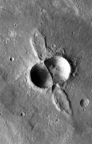
I’m fascinated by that dual crater but there doesn’t appear to be a caption!
Fixed!
Dual Crater? I would have guessed “Odd Balls”…
A beautiful collection of images if there ever was one! Thanks UT & NA! I like!
Short story suggestion generated by the sixth image: Hang gliding the edge of the North polar ice sheet one ‘warm’ summer day … I descended on to the flat plain of the valley below a large slide feature and began my studies.