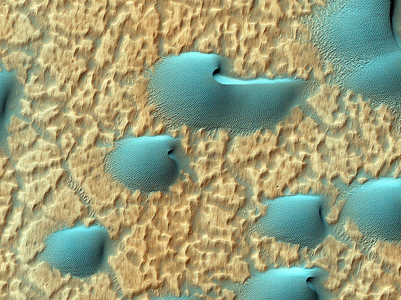
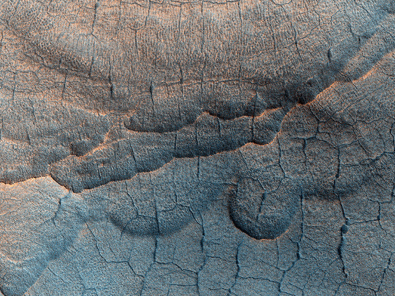
Dunes in Noachis Terra on Mars. Credit: NASA/JPL/University of Arizona
Who doesn’t love Mars? Amid the bad news of a U.S. government shutdown now stretching towards Day 12, there are still several spacecraft from NASA and the European Space Agency taking pictures of that red dot in the sky. Here are some recent stunners from the Red Planet.
Above is an infrared view of Noachis Terra as seen through the eyes of the Mars Reconnaissance Orbiter. The High Resolution Imaging Science Experiment (HiRISE) camera website (from the University of Arizona) released the picture on its website Oct. 2, with this description (in part):
“When there are perfect conditions for producing sand dunes — steady wind in one direction and just enough sand — barchan sand dunes form. The word ‘barchan’ is a Russian term because this type of dune was first described in the desert regions of Turkistan.”
MRO is run under a contract from NASA and is still operating, although its Twitter feed warns funds are running low.
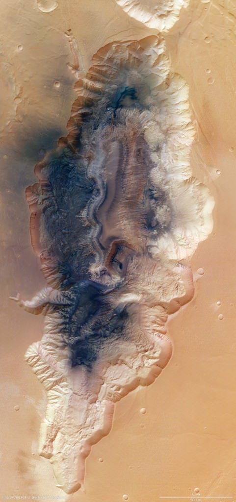
Mosaic of Hebes Chasma by ESA’s Mars Express. Credit: ESA/DLR/FU Berlin (G. Neukum)
Mars Express is a European Space Agency spacecraft and is thus not affected by the shutdown. This mosaic of eight images released Oct. 8 (above) shows Hebes Chasma, which is about 186 miles (300 kilometers) north of Valles Marineris. The trench is about five miles (eight kilometers) deep at its utmost, and hundreds of miles long. “A flat-topped mesa is located in the center of Hebes Chasma, which was likely shaped by the action of wind and water,” ESA wrote.
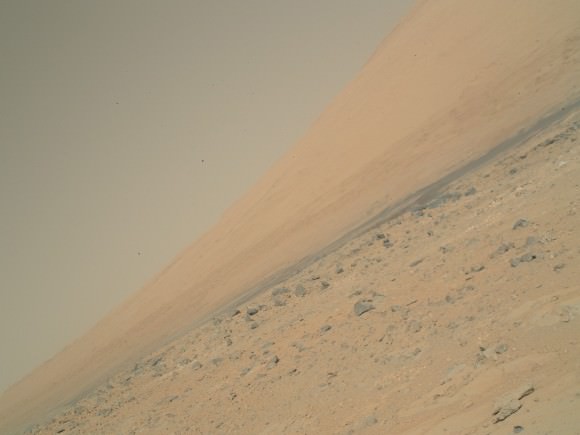
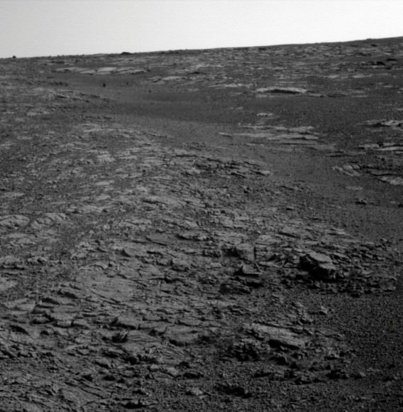
Meanwhile, the Curiosity and Opportunity rovers are still trundling away on Mars. NASA’s Jet Propulsion Laboratory is a contract operation and is still running its missions for the time being. These pictures were downloaded from the raw image sites for the rovers (here and here) as all press updates are suspended amid the shutdown.
Raw Mars Curiosity image on Oct. 3 of Mount Sharp (Aeolis Mons) using its Mars Hand Lens Imager (MAHLI). Credit: NASA/JPL-Caltech/MSSSRaw image of Opportunity’s view of the Martian horizon on Sol 3450 earlier in October. Credit: NASA/JPL-Caltech
The surface of Utopia Planitia on Mars. Credit: NASA/JPL/University of Arizona.
The name of this large impact basin on Mars, Utopia Planitia, sounds idyllic. But it also strikes a warm place in the heart of any Trekkie, as in the future (at least in the Star Trek Universe) it will be the location of the facility where the original Starship Enterprise and its many incarnations will be built. While the majority of the Utopia Planitia Shipyards are in geosynchronous orbit of Mars, there are also facilities on the planet as well, according to the Utopia Planitia Yards Starship Guide website. Uptopia Planitia was “found to be the ideal location [for the Shipyard], and a number of planetary sites are developed along with an expansive orbital facility located in geosynchronous orbit directly above,” explains the site.
But back to the present and this beautiful image from the HiRISE camera on board the Mars Reconnaissance Orbiter.
What is striking about the image are the polygon-shaped patterns of troughs and large scallop-shaped depressions. Mike Mellon, writing on the HiRISE website explains that collectively, such landforms are referred to as “thermokarst,” which both point to a slightly warmer and wetter Mars in the past.
Writes Mellon:
Under the proper climate conditions ice may form and seasonally accumulate in a honeycomb network of vertical fractures that appear when ice-rich soil contracts each winter. On Earth this form of subsurface ice is called an “ice wedge.” Special conditions are needed for this ice to accumulate and develop into a large wedge, namely warm temperature and abundant surface water. A thick layer of thawed wet soil forms allowing water to percolate into the open contraction cracks within the permafrost beneath. Later, loss of this wedge ice, by for example sublimation, results in deep depressions marking the honeycomb network.
Likewise, the larger scallop depressions might point to a past climate of frozen ponds or local patches of windblown snow collected in hollows. These surface ice deposits could later be covered by the ever-shifting soils and dust. In either case, the currently bitter cold and dry climate of Mars is not conducive to forming either of these buried-ice forms. Therefore, these landforms point to a warmer, but still cold, climate in the geologic past.
This image just highlights why I’m such a big fan of the HiRISE camera: a gorgeous image of our neighboring planet that was taken just last month from a spaceship orbiting Mars RIGHT NOW that tells us more about the past, while giving hope for our potentially space-faring future.
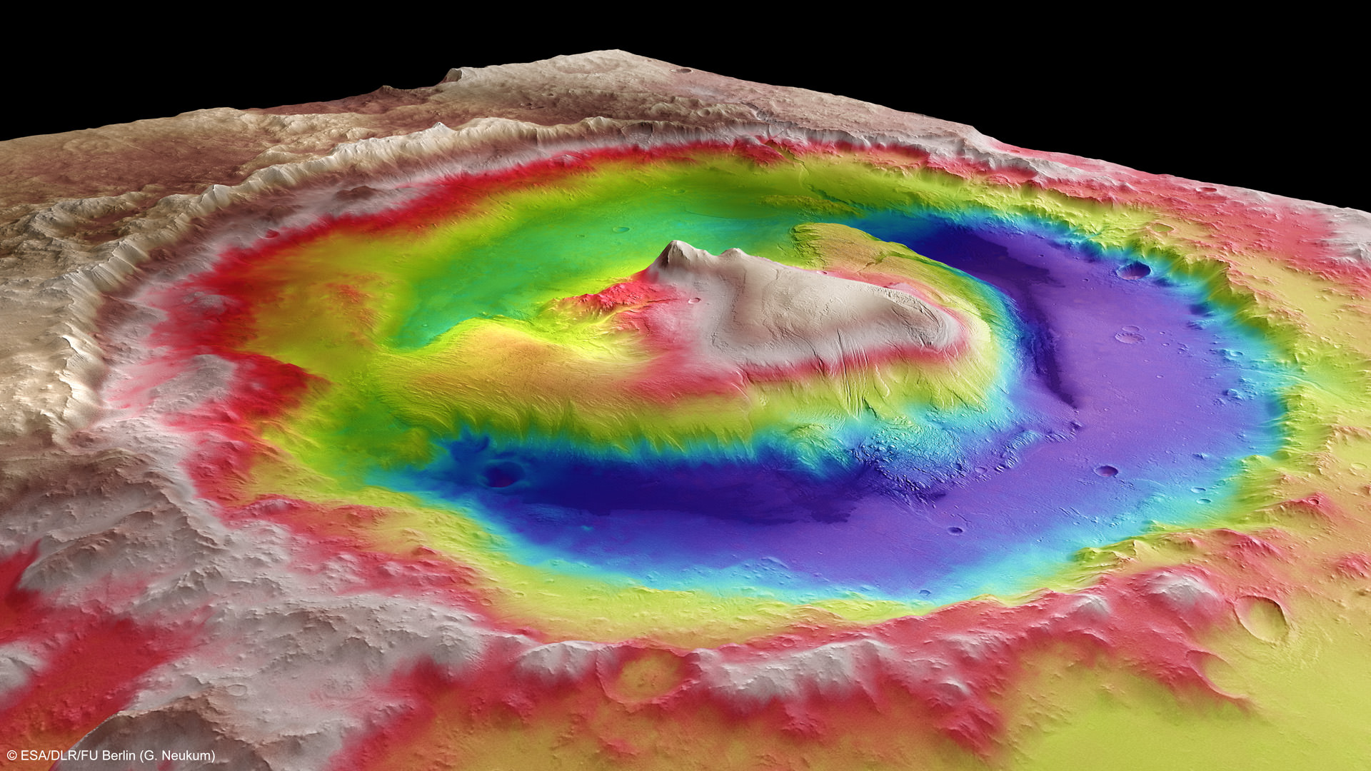
Mount Sharp inside Gale Crater - is the primary destination of NASA’s Curiosity rover mission to Mars. Curiosity landed on the right side of the mountain as shown here, near the dune field colored dark blue. Mount Sharp dominates Gale Crater. It is 3.4 mile (5.5 km) high. Gale Crater is 154 km wide. This image was taken by the High Resolution Stereo Camera (HRSC) of ESA’s Mars Express orbiter. Credit: ESA/DLR/FU Berlin (G. Neukum)
As NASA’s 1 ton Curiosity Mars rover sets out on her epic trek to the ancient sedimentary layers at the foothills of mysterious Mount Sharp, Universe Today conducted an exclusive interview with the Curiosity Project Manager Jim Erickson, of NASA’s Jet Propulsion Laboratory (JPL) to get the latest scoop so to speak on the robots otherworldly adventures.
The science and engineering teams are diligently working right now to hasten the rovers roughly year long journey to the 3.4 mile (5.5 km) high Martian mountain – which is the mission’s chief destination and holds caches of minerals that are key to sparking and sustaining life.
“We have departed Glenelg and the Shaler outcrop and started to Mount Sharp,” Erickson told me.
Mount Sharp lies about 5 miles (8 kilometers) distant – as the Martian crow flies.
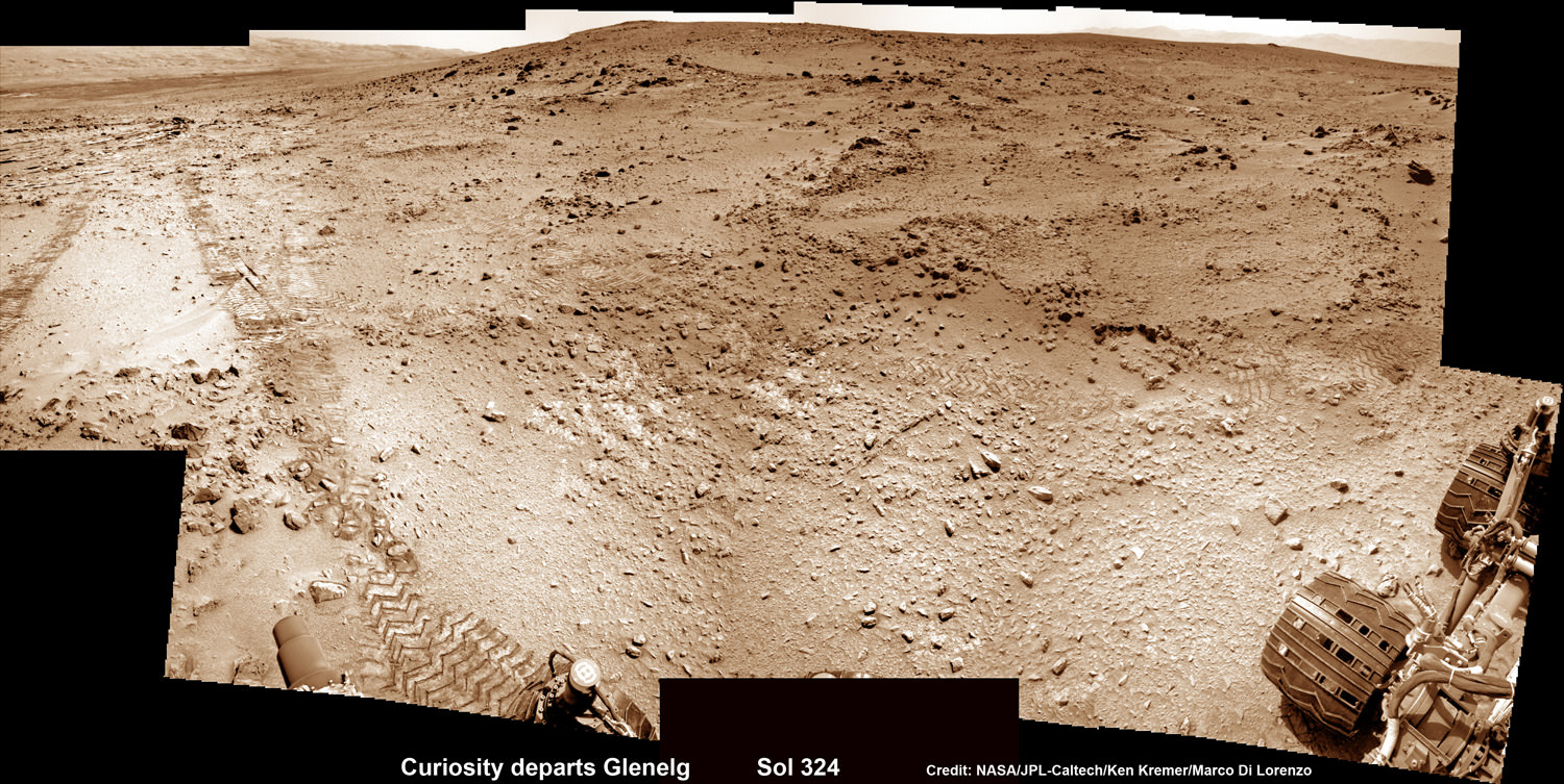
Curiosity Sets Sail for Mount Sharp
This photomosic shows NASA’s Curiosity departing at last for Mount Sharp- her main science destination. Note the wheel tracks on the Red Planet’s surface. The navcam camera images were taken on July 4, 2013 (Sol 324). Credit: NASA/JPL-Caltech/Ken Kremer (kenkremer.com)/Marco Di Lorenzo
Curiosity will have to traverse across potentially treacherous dune fields on the long road ahead to the layered mountain.
“Things are going very well and we have a couple of drives under our belt,” said Erickson.
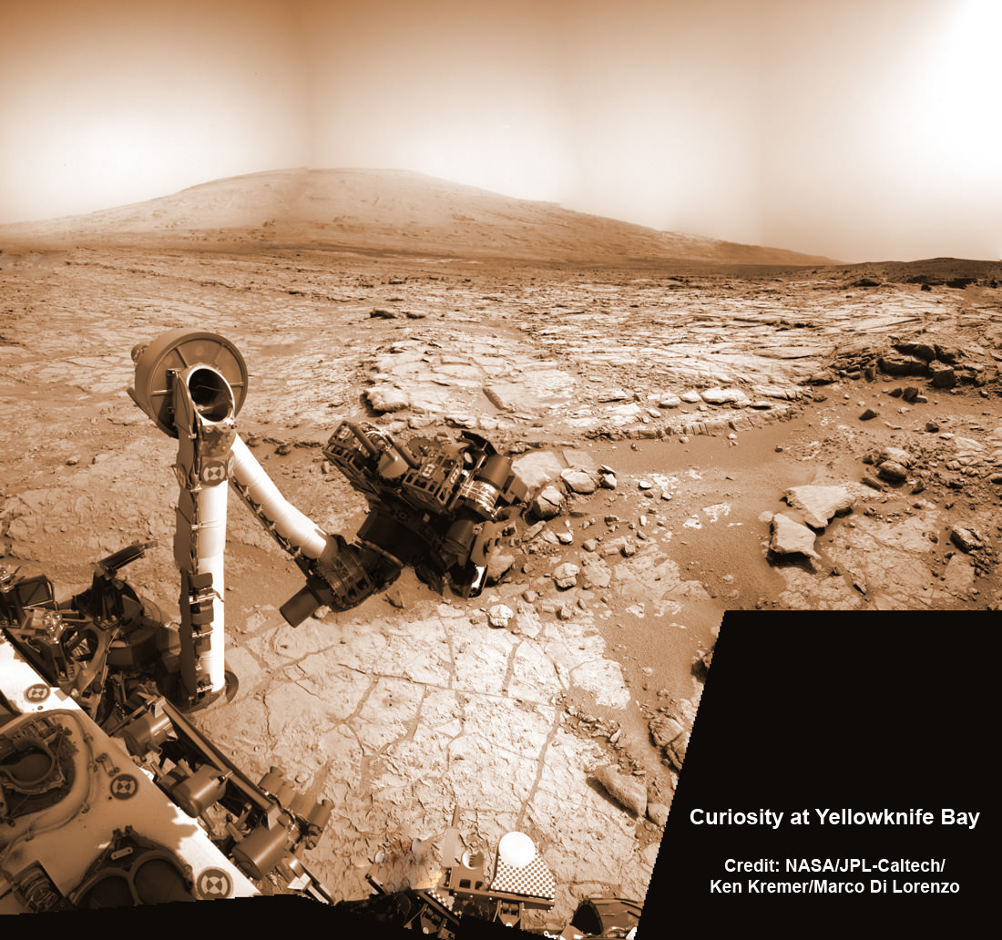
Curiosity just completed more than half a year’s worth of bountiful science at Glenelg and Yellowknife Bay where she discovered a habitable environment on the Red Planet with the chemical ingredients that could sustain Martian microbes- thereby already accomplishing the primary goal of NASA’s flagship mission to Mars.
Curiosity’s handlers are upgrading the rovers ‘brain’ with new driving software, making her smarter, more productive and capable than ever before, and also far more independent since her breathtaking touchdown inside Gale Crater nearly a year ago on Aug. 6, 2012.
“We continue to drive regularly. The next drive is planned tomorrow and will be executed the following day.”
As of today (Sol 336, July 17), Curiosity has driven six times since leaving Glenelg on July 4 (Sol 324), totaling more than 180 meters.
Curiosity’s Traverse Map Through Sol 333
This map shows the route driven by NASA’s Mars rover Curiosity through Sol 333 of the rover’s mission on Mars (July 14, 2013). Numbering of the dots along the line indicate the sol number of each drive. North is up. The scale bar is 200 meters (656 feet). From Sol 331 to Sol 333, Curiosity had driven a straight line distance of about 45.05 feet (13.73 meters). The base image from the map is from the High Resolution Imaging Science Experiment Camera (HiRISE) in NASA’s Mars Reconnaissance Orbiter. Credit: NASA/JPL-Caltech/Univ. of Arizona
Scientists specifically targeted Curiosity to Gale Crater and Mount Sharp because it is loaded with deposits of clay minerals that form in neutral water and that could possibly support the origin and evolution of simple Martian life forms, past or present.
Erickson has worked in key positions on many NASA planetary science missions dating back to Viking. These include the Galileo mission to Jupiter, both MER rovers Spirit & Opportunity, as well as a stint with the Mars Reconnaissance Orbiter (MRO).
Here is Part 1 of my wide ranging conversation with Jim Erickson, Curiosity Project Manager of JPL. Part 2 will follow.
I asked Erickson to describe the new driving software called autonomous navigation, or autonav, and how it will help speed Curiosity on her way. Until now, engineers on Earth did most of the planning for her.
Jim Erickson: We have put some new software – called autonav, or autonomous navigation – on the vehicle right after the conjunction period back in March 2013. This will increase our ability to drive.
The reason we put it on-board is that we knew it would be helpful when we started the long drive to Mount Sharp. And we are itching to check that out. Over the next few weeks we will be doing various tests with the autonav.
Ken Kremer: How will autonav help Curiosity?
Jim Erickson: The rover will have the ability to understand how far it’s driving, whether its slipping or not, and to improve safety.
And then the next step will be in effect to allow the rover to drive on its own.
Ken: How often will Curiosity drive?
Jim Erickson: Somewhere like every other day or so. We plan a drive, see how it goes and whether it went well and then we move further to the next drive. We are implementing that as it stands while we do the checkouts of autonav.
We might have to stop driving for part of the autonav checkout to complete the testing.
Basically we are limited mainly by the amount of days that we have successful completion of the previous day’s drive. And whether we have the information come back down [to Earth] so that we can plan the next day’s drive.
In some circumstances Mars time can rotate so that we don’t get the data back in time, so therefore we won’t be driving that day.
Ken: Can you ever drive two days in a row?
Jim Erickson: Yes we can, if the timing is right. If we get the results of the day’s drive (n) in time before we have to plan the next day’s drive (n+1) – almost as if you’re on Mars time. Then that would work fine.
Also, when we get the autonav capability we can plan two days in row. One day of directed driving and the second day can be ‘OK here’s your target from wherever you end up, try and go to this spot’.
This will increase the productivity!
Ken: When will autonav be up and running?
Jim Erickson: Something like two to three weeks. We need to thoroughly look at all the tests and validate them first so that we’re all comfortable with autonav.
Ken: What’s the Martian terrain on the floor of Gale crater like right now and for the next few miles?
Jim Erickson: It’s a mix of sand and different flagstone areas. As we get into it we’ll need to be able to drive comfortably on both. There aren’t too many large rocks that would be a problem right now. There is some shelf area that we’ll be going around.
Right now the area we’re in is actually a good thing to give us practice identifying obstacles and getting around them. This will help us later on when we see obstacles and want to be driving quicker.
Ken: What’s the overall plan now, a focus on driving or stopping and investigating?
Jim Erickson: – It’s not the intent to be stopping. This will be a good couple of weeks driving.
In Part 2 of my conversation with Jim Erickson we’ll discuss more about the rover’s traverse across alien territory that’s simultaneously a science gold mine and a potential death trap, as well as drilling and sampling activities, Comet ISON observations and upcoming science objectives.
Previous experience with rovers on Mars will be enormously helpful in studying how the rover interacts with dune fields. Autonav was first employed on the MER rovers.
The rover drivers and science team gained lots of experience and know how while driving both Spirit & Opportunity through numerous gigantic fields of dunes of highly varying composition and complexity.
NASA’s Curiosity rover reaches out in ‘handshake’ like gesture with dramatic scenery of Mount Sharp in the background. This mosaic of images was snapped by Curiosity on Sol 262 (May 2, 2013) and shows her flexing the robotic arm. Two drill holes are visible on the surface bedrock below the robotic arm’s turret. Credit: NASA/JPL-Caltech/Ken Kremer-(kenkremer.com)/Marco Di LorenzoCuriosity Route Map From ‘Glenelg’ to Mount Sharp
This map shows where NASA’s Mars rover Curiosity landed in August 2012 at “Bradbury Landing”; the area where the rover worked from November 2012 through May 2013 at and near the “John Klein” target rock in the “Glenelg” area; and the mission’s next major destination, the entry point to the base of Mount Sharp. Credit: NASA/JPL-Caltech/Univ. of Arizona
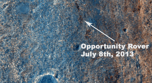
This image taken by the High Resolution Imaging Science Experiment (HiRISE) camera on NASA's Mars Reconnaissance Orbiter on July 8, 2013, captures Opportunity traversing south (at the end of the white arrow) to new science targets and a winter haven at "Solander Point," another portion of the Endeavour rim. The relatively level ground between Cape York and Solander Point is called "Botany Bay." The image was taken 10 years after Opportunity was launched from Florida on July 7, 2013, EDT and PDT (July 8, Universal Time). Image credit: NASA/JPL-Caltech/Univ. of Arizona.
Ten years to the day after the Opportunity rover launched to Mars, the HiRISE camera on the Mars Reconnaissance Orbiter snapped this image of the rover, still toiling away on the surface of Mars. The white dot in the image is Oppy, as the rover was crossing the level ground called “Botany Bay” on its way to a rise called “Solander Point.” We’re looking into whether there’s a way to determine if the rover was actually moving at the time the image was taken.
This, of course, is not the first time HiRISE has found the various rovers on Mars’ surface. Images from orbit help rover drivers find safe routes, as well as helping to identify enticing science targets for future investigation.
“The Opportunity team particularly appreciates the color image of Solander Point because it provides substantially more information on the terrains and traverse that Opportunity will be conducting over the next phase of our exploration of the rim of Endeavour crater,” said Mars Science Laboratory Project Scientist Matt Golombek, from JPL.
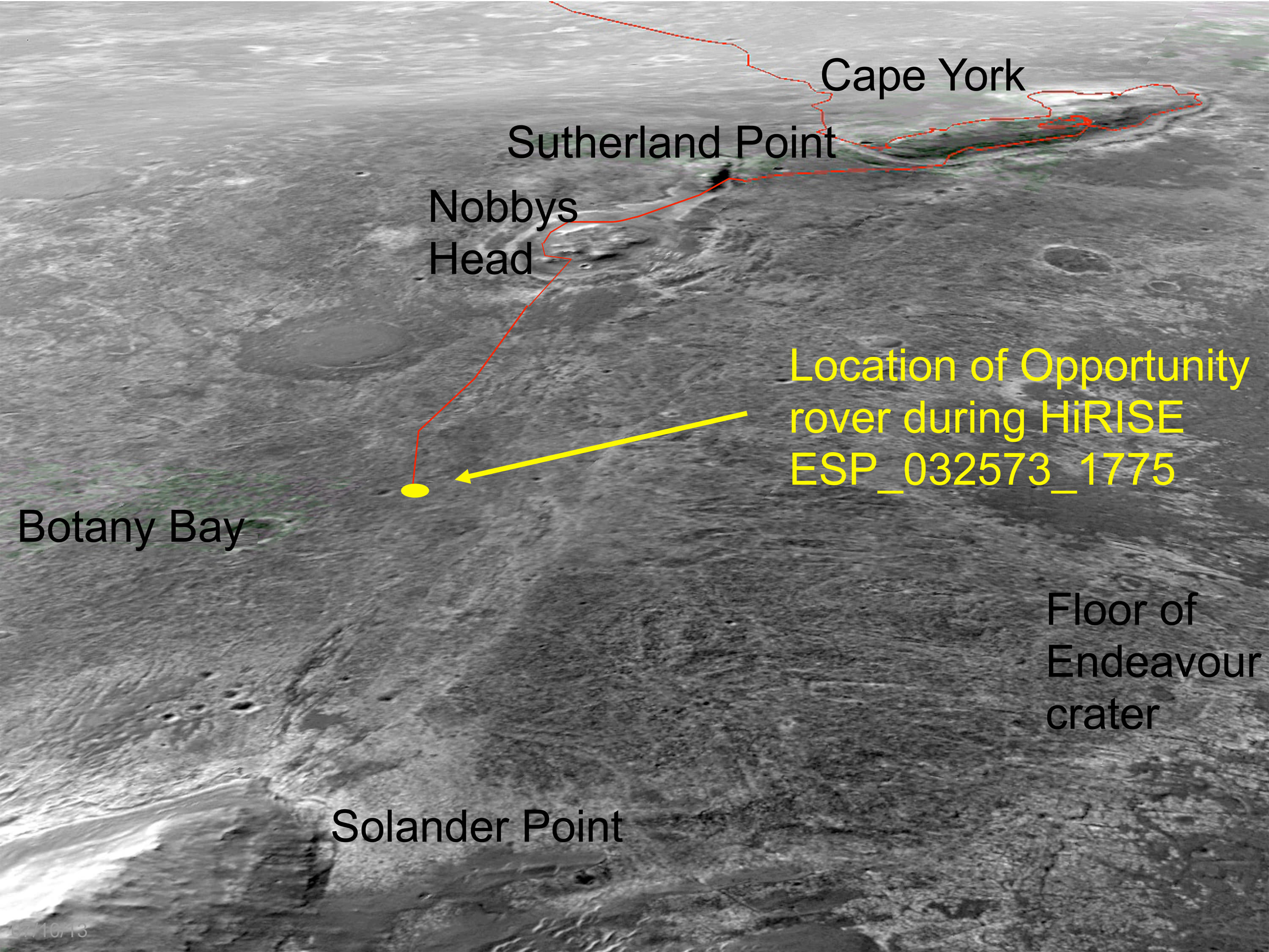
an oblique, northward-looking view based on stereo orbital imaging, shows the location of Opportunity on its journey from Cape York to Solander Point when HiRISE took the new color image. Endeavour Crater is about 14 miles (22 kilometers) in diameter. The distance from Cape York to Solander Point is about 1.2 miles (2 kilometers). The red line indicates the path the rover has driven. Credit: NASA/JPL-Caltech/Univ. of Arizona.
Opportunity currently holds the US space program’s all-time record for distance traversed on another planetary body at greater than 36 kilometers or 22 miles. The Lunar Reconnaissance Orbiter team recently confirmed that the Lunokhod 2 rover traveled 42 km (26 miles) on the Moon.
Opportunity was launched from on July 7, 2003, PDT and EDT (July 8, Universal Time). Opportunity has been on the western rim of 20-kilometer-diameter Endeavour Crater in Meridiani Planum for about two years investigating the 3 to 4 billion-year-old sedimentary layers of Cape York. Now the rover is traversing south to new science targets and a winter haven at Solander Point.
Several types of downhill flow features have been observed on Mars. This image from the High Resolution Imaging Science Experiment (HiRISE) camera on NASA's Mars Reconnaissance Orbiter is an example of a type called "linear gullies." Image credit: NASA/JPL-Caltech/Univ. of Arizona
Extreme sports taking on place on Mars? How about snowboarding – or actually sandboarding –down Martian dunes on a cushion of carbon dioxide? Sounds fun, and this might be happening already – sans the humanoid snowboarders, however.
Scientists have been wondering what caused unusual hillside grooves on Mars, called linear gullies. New research and test runs down sand dunes here on Earth has shown that these gullies may be formed by chunks of frozen carbon dioxide sliding down some Martian sand dunes on cushions of gas. They are plowing furrows as they slide, and creating open pits at the bottom of the run.
And these are not the Martian Sand Skimmers of Martian Chronicles fame. Just chunks of dry ice going for a joy ride.
“I have always dreamed of going to Mars,” said Serina Diniega, a planetary scientist at NASA’s Jet Propulsion Laboratory and lead author of a report published online by the journal Icarus. “Now I dream of snowboarding down a Martian sand dune on a block of dry ice.”
In images from the Mars Reconnaissance Orbiter’s HiRISE (High Resolution Imaging Science Experiment) camera the linear gullies seem to all have relatively constant width — up to a few yards, or meters, across — with raised banks or levees along the sides. Unlike gullies caused by water flows on Earth and possibly on Mars, they do not have aprons of debris at the downhill end of the gully. Instead, many have pits at the downhill end.
“In debris flows, you have water carrying sediment downhill, and the material eroded from the top is carried to the bottom and deposited as a fan-shaped apron,” said Diniega. “In the linear gullies, you’re not transporting material. You’re carving out a groove, pushing material to the sides.”
HiRISE images show the sand dunes with linear gullies covered by carbon-dioxide frost during the Martian winter. The location of the linear gullies is on dunes that spend the Martian winter covered by carbon-dioxide frost. By comparing before-and-after images from different seasons, researchers determined that the grooves are formed during early spring. Some images have even caught bright objects in the gullies.
Diniega and her team theorize the bright objects are pieces of dry ice that have broken away from points higher on the slope. According to the new hypothesis, the pits could result from the blocks of dry ice completely sublimating away into carbon-dioxide gas after they have stopped traveling.
“Linear gullies don’t look like gullies on Earth or other gullies on Mars, and this process wouldn’t happen on Earth,” said Diniega. “You don’t get blocks of dry ice on Earth unless you go buy them.”
Co-author on the paper Candice Hansen, of the Planetary Science Institute suspected that dry ice might be involved in forming these linear gullies, so like any good planetary scientist she bought some slabs of dry ice at a supermarket and slid them down sand dunes.
And voilà, similar looking linear gullies with the gaseous carbon dioxide from the thawing ice maintaining a lubricating layer under the slab. As the chunk slide down the dune, it also pushed sand aside into small levees. Handsen said the slabs glided down even low-angle slopes, not much pushing required.
Of course, the team said, the outdoor tests did not simulate Martian temperature and pressure, but calculations indicate the dry ice would act similarly in early Martian spring where the linear gullies form. Although water ice, too, can sublimate directly to gas under some Martian conditions, it would stay frozen at the temperatures at which these gullies form, the researchers calculate.
“MRO is showing that Mars is a very active planet,” Hansen said. “Some of the processes we see on Mars are like processes on Earth, but this one is in the category of uniquely Martian.”
Hansen also noted the process could be unique to the linear gullies etched on Martian sand dunes.
“There are a variety of different types of features on Mars that sometimes get lumped together as ‘gullies,’ but they are formed by different processes,” she said. “Just because this dry-ice hypothesis looks like a good explanation for one type doesn’t mean it applies to others.”
Harrumph. Dry ice having fun on Mars fun without us.
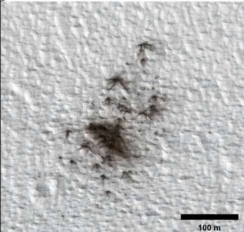
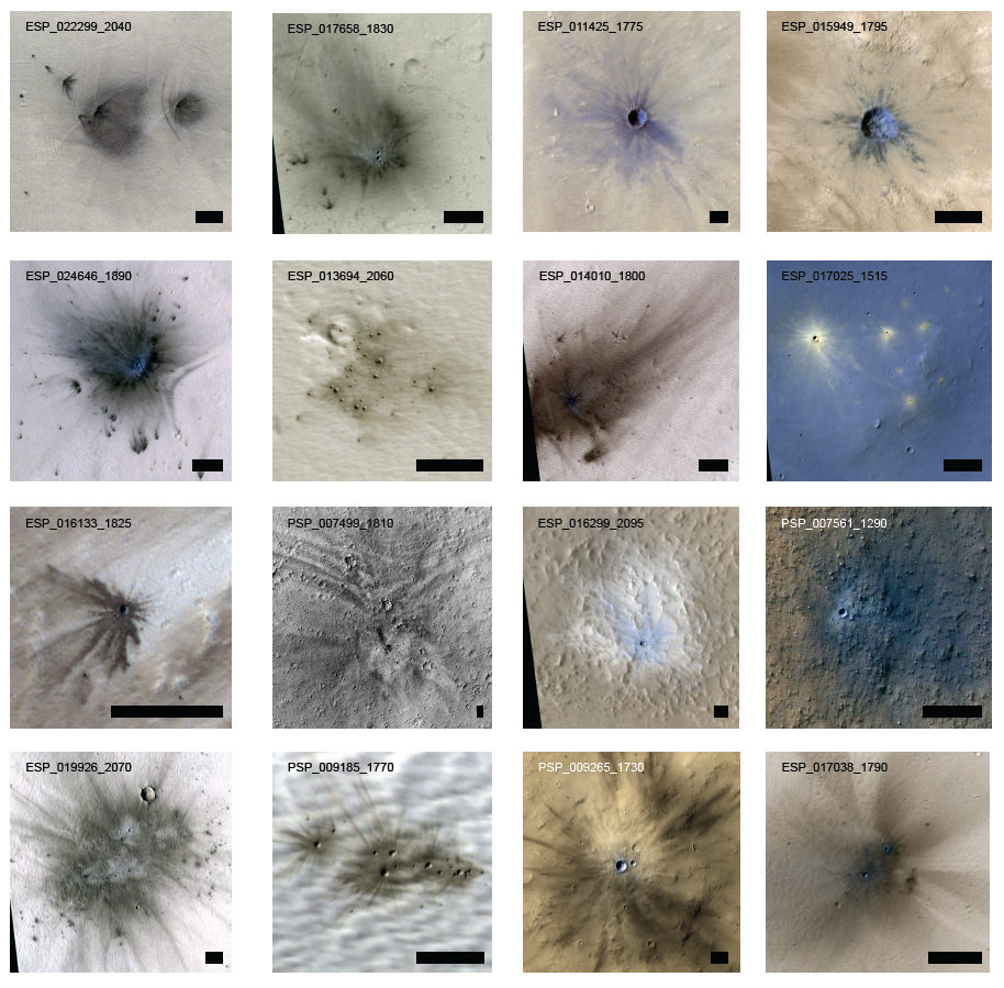
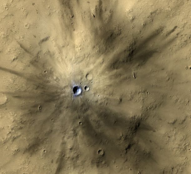
A relatively new cluster of impact craters on Mars as seen by the HiRISE camera on the Mars Reconnaissance Orbiter. Credit: NASA/JPL-Caltech/MSSS/Univ. of Arizona
One of the benefits of having a spacecraft in orbit around another planet for several years is the ability to make long-term observations and interpretations. The Mars Reconnaissance Orbiter has been orbiting Mars for over seven years now, and by studying before-and-after images from the High Resolution Imaging Science Experiment (HiRISE) camera, scientists have been able to estimate that the Red Planet gets womped by more than 200 small asteroids or bits of comets per year, forming craters at least 3.9 meters (12.8 feet) across.
“It’s exciting to find these new craters right after they form,” said Ingrid Daubar of the University of Arizona, Tucson, lead author of the paper published online this month by the journal Icarus. “It reminds you Mars is an active planet, and we can study processes that are happening today.”
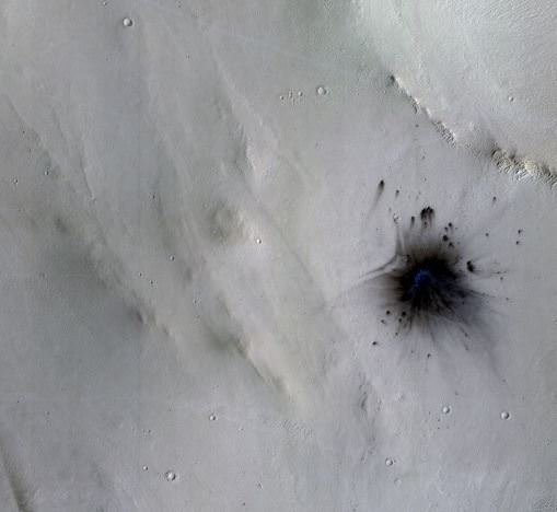
New impact site on Mars formed between November 2005 and October 2010. Credit: NASA/JPL-Caltech/MSSS/Univ. of Arizona
Over the last decade, researchers have identified 248 new impact sites on parts of the Martian surface in the past decade from spacecraft images, determining when the craters appeared. The 200-per-year planetwide estimate is a calculation based on the number found in a systematic survey of a portion of the planet.
The orbiters took pictures of the fresh craters at sites where before-and-after images by other cameras helped figure out when the impacts occurred. This combination provided a new way to make direct measurements of the impact rate on Mars. This will lead to better age estimates of recent features on Mars.
Daubar and co-authors calculated a rate for how frequently new craters at least 3.9 meters in diameter are excavated. The rate is equivalent to an average of one each year on each area of the Martian surface roughly the size of the U.S. state of Texas. Earlier estimates pegged the cratering rate at three to 10 times more craters per year. They were based on studies of craters on the moon and the ages of lunar rocks collected during NASA’s Apollo missions in the late 1960s and early 1970s.
“Mars now has the best-known current rate of cratering in the solar system,” said HiRISE Principal Investigator Alfred McEwen of the University of Arizona, a co-author on the paper.
Examples of craters listed in the paper ‘The Current Martian Cratering Rate.’ Credit: NASA/JPL/Univ. of Arizona.
These asteroids, or comet fragments, typically are no more than 3 to 6 feet (1 to 2 meters) in diameter. Space rocks too small to reach the ground on Earth cause craters on Mars because the Red Planet has a much thinner atmosphere.
For comparison, the meteor over Chelyabinsk, Russia, in February was about 10 times bigger than the objects that dug the fresh Martian craters.
HiRISE targeted places where dark spots had appeared during the time between images taken by the spacecraft’s Context Camera (CTX) or cameras on other orbiters. The new estimate of cratering rate is based on a portion of the 248 new craters detected. It comes from a systematic check of a dusty fraction of the planet with CTX since late 2006. The impacts disturb the dust, creating noticeable blast zones. In this part of the research, 44 fresh impact sites were identified.
Estimates of the rate at which new craters appear serve as scientists’ best yardstick for estimating the ages of exposed landscape surfaces on Mars and other worlds.
One of many fresh impact craters spotted by the UA-led HiRISE camera, orbiting the Red Planet on board NASA’s Mars Reconnaissance Orbiter since 2006. (Photo: NASA/JPL-Caltech/MSSS/UA).
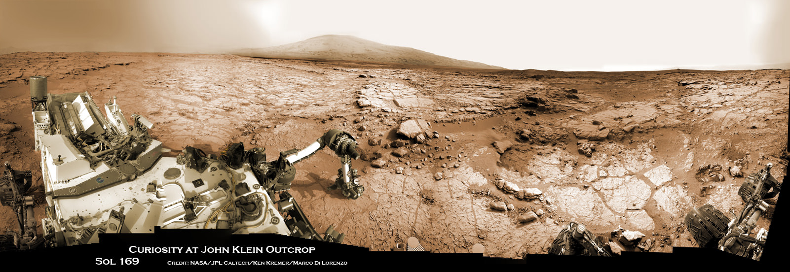
Curiosity accomplished historic 1st drilling into Martian rock at John Klein outcrop on Feb 8, 2013 (Sol 182), shown in this context mosaic view of the Yellowknife Bay basin taken on Jan. 26 (Sol 169) - back dropped with Mount Sharp - where the robot is currently working. Curiosity will bore a 2nd drill hole soon following the resumption of contact with the end of the solar conjunction period. Credit: NASA/JPL-Caltech/Ken Kremer/Marco Di Lorenzo
Curiosity accomplished historic 1st drilling into Martian rock at John Klein outcrop on Feb 8, 2013 (Sol 182), shown in this context mosaic view of the Yellowknife Bay basin taken on Jan. 26 (Sol 169) – back dropped with Mount Sharp – where the robot is currently working. Curiosity will bore a 2nd drill hole soon following the resumption of contact with the end of the solar conjunction period. Credit: NASA/JPL-Caltech/Ken Kremer/Marco Di Lorenzo
See drill hole and conjunction videos below[/caption]
After taking a well deserved and unavoidable break during April’s solar conjunction with Mars that blocked two way communication with Earth, NASA’s powerful Martian fleet of orbiters and rovers have reestablished contact and are alive and well and ready to Rock ‘n Roll ‘n Drill.
“Both orbiters and both rovers are in good health after conjunction,” said NASA JPL spokesman Guy Webster exclusively to Universe Today.
Curiosity’s Chief Scientist John Grotzinger confirmed to me today (May 1) that further drilling around the site of the initial John Klein outcrop bore hole is a top near term priority.
The goal is to search for the chemical ingredients of life.
“We’ll drill a second sample,” Grotzinger told Universe Today exclusively. Grotzinger, of the California Institute of Technology in Pasadena, Calif., leads NASA’s Curiosity Mars Science Laboratory mission.
“We’ll move a small bit, either with the arm or the wheels, and then drill another hole to confirm what we found in the John Klein hole.”
Earth, Mars and the Sun have been lined up in nearly a straight line for the past several weeks, which effectively blocked virtually all contact with NASA’s four pronged investigative Armada at the Red Planet.
NASA’s Red Planet fleet consists of the Curiosity (MSL) and Opportunity (MER) surface rovers as well as the long lived Mars Odyssey (MO) and Mars Reconnaissance Orbiter (MRO) robotic orbiters circling overhead. ESA’s Mars Express orbiter is also exploring the Red Planet.
“All have been in communications,” Webster told me today, May 1.
The NASA spacecraft are functioning normally and beginning to transmit the science data collected and stored in on board memory during the conjunction period when a commanding moratorium was in effect.
“Lots of data that had been stored on MRO during conjunction has been downlinked,” Webster confirmed to Universe Today.
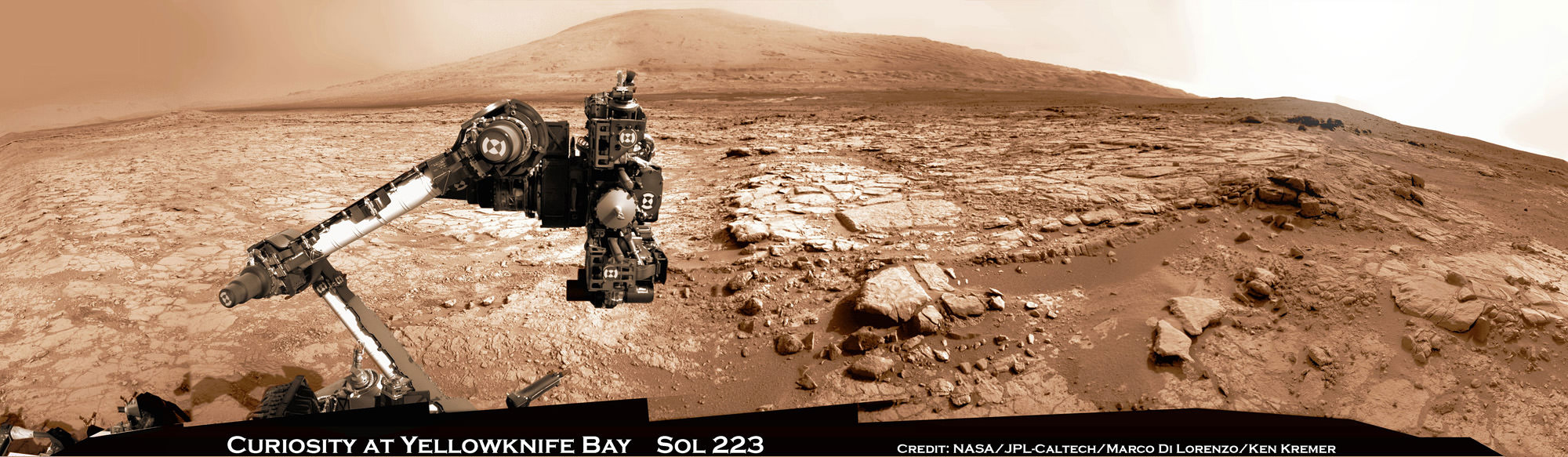
Curiosity and Mount Sharp: Curiosity’s elevated robotic arm and drill stare back at you at the John Klein drill site – back dropped by mysterious Mount Sharp. The rover has resumed contact with NASA following the end of solar conjunction. This panoramic vista was snapped on March 23, 2013, Sol 223. Credit: NASA/JPL-Caltech/Marco Di Lorenzo/KenKremer (kenkremer.com)
And NASA is already transmitting and issuing new marching orders to the Martian Armada to resume their investigations into unveiling the mysteries of the Red Planet and determine whether life ever existed eons ago or today.
“New commanding, post-conjunction has been sent to both orbiters and Opportunity.”
“And the sequence is being developed today for sending to Curiosity tonight (May 1), as scheduled more than a month ago,” Webster explained.
“We’ll spend the next few sols transitioning over to new flight software that gives the rover additional capabilities,” said Grotzinger.
“After that we’ll spend some time testing out the science instruments on the B-side rover compute element – that we booted to before conjunction.”
Curiosity is at work inside the Yellowknife Bay basin just south of the Martian equator. Opportunity is exploring the rim of Endeavour crater at the Cape York rim segment.
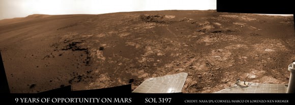
Opportunity Celebrates 9 Years and 3200 Sols on Mars snapping this panoramic view from her current location on ‘Matijevic Hill’ at Endeavour Crater. The rover discovered phyllosilicate clay minerals and calcium sulfate veins at the bright outcrops of ‘Whitewater Lake’, at right, imaged by the Navcam camera on Sol 3197 (Jan. 20, 2013). “Copper Cliff” is the dark outcrop, at top center. Darker “Kirkwood” outcrop, at left, is site of mysterious “newberries” concretions. Credit: NASA/JPL-Caltech/Cornell/Marco Di Lorenzo/Ken Kremer
Mars Solar Conjunction is a normal celestial event that occurs naturally about every 26 months. The science and engineering teams take painstaking preparatory efforts to insure no harm comes to the spacecraft during the conjunction period when they have no chance to assess or intervene in case problems arise.
So it’s great news and a huge relief to the large science and operations teams handling NASA’s Martian assets to learn that all is well.
Since the sun can disrupt and garble communications, mission controllers suspended transmissions and commands so as not to inadvertently create serious problems that could damage the fleet in a worst case scenario.
So what’s on tap for Curiosity and Opportunity in the near term ?
“For the first few days for Curiosity we will be installing a software upgrade.”
“For both rovers, the science teams will be making decisions about how much more to do at current locations before moving on,” Webster told me.
The Opportunity science team has said that the long lived robot has pretty much finished investigating the Cape York area at Endeavour crater where she made the fantastic discovery of phyllosilicates clay minerals that form in neutral water.
Signals from Opportunity received a few days ago on April 27 indicated that the robot had briefly entered a standby auto mode while collecting imagery of the sun.
NASA reported today that all operations with Opportunity was “back under ground control, executing a sequence of commands sent by the rover team”, had returned to normal and the robot exited the precautionary status.
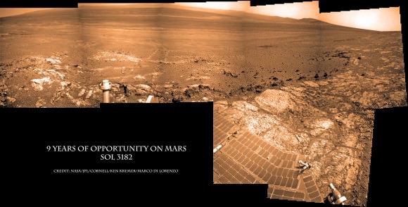
Opportunity Celebrates 9 Years on Mars snapping this panoramic view of the vast expanse of 14 mile (22 km) wide Endeavour Crater from atop ‘Matijevic Hill’ on Sol 3182 (Jan. 5, 2013). The rover then drove 43 feet to arrive at ‘Whitewater Lake’ and investigate clay minerals. Photo mosaic was stitched from Navcam images and colorized. Credit: NASA/JPL-Caltech/Cornell/Ken Kremer/Marco Di Lorenzo
“The Curiosity team has said they want to do at least one more drilling in Yellowknife Bay area,” according to Webster.
Curiosity has already accomplished her primary task and discovered a habitable zone that possesses the key ingredients needed for potential alien microbes to once have thrived in the distant past on the Red Planet when it was warmer and wetter.
The robot found widespread evidence for repeated episodes of flowing liquid water, hydrated mineral veins and phyllosilicates clay minerals on the floor of her Gale Crater landing site after analyzing the first powder ever drilled from a Martian rock.
Video Caption: Historic 1st bore hole drilled by NASA’s Curiosity Mars rover on Sol 182 of the mission (8 Feb 2013). Credit: NASA/JPL-Caltech/MSSS/Marco Di Lorenzo/Ken Kremer (http://www.kenkremer.com/)
During conjunction Curiosity collected weather, radiation and water measurements but no imagery.
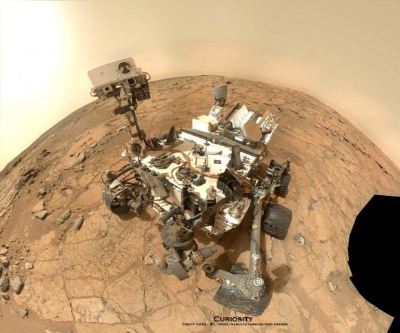
Curiosity Rover snapped this self portrait mosaic with the MAHLI camera while sitting on flat sedimentary rocks at the “John Klein” outcrop where the robot conducted historic first sample drilling inside the Yellowknife Bay basin, on Feb. 8 (Sol 182) at lower left in front of rover. The photo mosaic was stitched from raw images snapped on Sol 177, or Feb 3, 2013, by the robotic arm camera – accounting for foreground camera distortion. Credit: NASA/JPL-Caltech/MSSS/Marco Di Lorenzo/KenKremer (kenkremer.com).
Watch this brief NASA JPL video for an explanation of Mars Solar Conjunction.
A closeup of an impact crater shows distinctive bright lines and spots on the steep slope, indicating bouncing boulders have fallen down the incline. Credit: NASA/JPL/University of Arizona.
What are the types of things that happen on Mars when we’re not looking? Some things we’ll never know, but scientists with the HiRISE camera on the Mars Reconnaissance Orbiter have seen evidence of bouncing boulders. They haven’t actually captured boulders in the act of rolling and bouncing down the steep slope of an impact crater (but they have captured avalanches while they were happening!)
Instead, they see distinctive bright lines and spots on the side of a crater, and these patterns weren’t there the last time HiRISE imaged this crater 5 years ago (2.6 Mars years ago), in March 2008.
“The discontinuous bright spots indicate bouncing, so we interpret these features as due to boulders bouncing and rolling down the slope,” said HiRISE principal investigator Alfred McEwen, writing on the HiRISE website.
Where did the boulders come from?
“Maybe they fell off of the steep upper cliffs of the crater, although we don’t see any new bright features there that point to the source,” McEwen said. “Maybe the rocks were ejecta from a new impact event somewhere nearby.”
The trails are quite bright, and McEwen said that perhaps the shallow subsurface soil here is generally brighter than the surface soil, just like part of Gusev Crater, as the Spirit rover found. McEwen added that the brightness can’t be from ice because this is a warm equator-facing slope seen in the summer.
Curiosity and Mount Sharp - Parting Shot ahead of Solar Conjunction. Enjoy this parting view of Curiosity's elevated robotic arm and drill are staring at you - back dropped with her ultimate destination - Mount Sharp - in this panoramic vista of Yellowknife Bay basin snapped on March 23, Sol 223, by the rover's navigation camera system. The raw images were stitched by Marco Di Lorenzo and Ken Kremer and colorized. Credit: NASA/JPL-Caltech/Marco Di Lorenzo/KenKremer (kenkremer.com). See video below explaining Mars Solar Conjunction
Curiosity and Mount Sharp – Parting Shot ahead of Mars Solar Conjunction
Enjoy this parting view of Curiosity’s elevated robotic arm and drill staring at you; back dropped with her ultimate destination – Mount Sharp – in this panoramic vista of Yellowknife Bay basin snapped on March 23, Sol 223, by the rover’s navigation camera system. The raw images were stitched by Marco Di Lorenzo and Ken Kremer and colorized. Credit: NASA/JPL-Caltech/Marco Di Lorenzo/KenKremer (kenkremer.com)
See video below explaining Mars Solar Conjunction[/caption]
Earth’s science invasion fleet at Mars is taking a break from speaking with their handlers back on Earth.
Why ? Because as happens every 26 months, the sun has gotten directly in the way of Mars and Earth.
Earth, Mars and the Sun are lined up in nearly a straight line. The geometry is normal and it’s called ‘Mars Solar Conjunction’.
Conjunction officially started on April 4 and lasts until around May 1.
From our perspective here on Earth, Mars will be passing behind the Sun.
Watch this brief NASA JPL video for an explanation of Mars Solar Conjunction.
Therefore the Terran fleet will be on its own for the next month since the sun will be blocking nearly all communications.
In fact since the sun can disrupt and garble communications, mission controllers will be pretty much suspending transmissions and commands so as not to inadvertently create serious problems that could damage the fleet in a worst case scenario.
Right now there are a trio of orbiters and a duo of rovers from NASA and ESA exploring Mars.
The spacecraft include the Curiosity (MSL) and Opportunity (MER) rovers from NASA. Also the Mars Express orbiter from ESA and the Mars Odyssey (MO) and Mars Reconnaissance Orbiter (MRO) from NASA.
Geometry of Mars Solar Conjunction
Because several of these robotic assets have been at Mars for nearly 10 years and longer, the engineering teams have a lot of experience with handling them during the month long conjunction period.
“This is our sixth conjunction for Odyssey,” said Chris Potts of JPL, mission manager for NASA’s Mars Odyssey, which has been orbiting Mars since 2001. “We have plenty of useful experience dealing with them, though each conjunction is a little different.”
But there is something new this go round.
“The biggest difference for this 2013 conjunction is having Curiosity on Mars,” Potts said. Odyssey and the Mars Reconnaissance Orbiter relay almost all data coming from Curiosity and the Mars Exploration Rover Opportunity, as well as conducting the orbiters’ own science observations.
The rovers and orbiters can continue working and collecting science images and spectral data.
But that data will all be stored in the on board memory for a post-conjunction playback starting sometime in May.
Learn more about Curiosity’s groundbreaking discoveries and NASA missions at Ken’s upcoming lecture presentations:
April 20/21 : “Curiosity and the Search for Life on Mars – (in 3-D)”. Plus Orion, SpaceX, Antares, the Space Shuttle and more! NEAF Astronomy Forum, Suffern, NY
April 28: “Curiosity and the Search for Life on Mars – (in 3-D)”. Plus the Space Shuttle, SpaceX, Antares, Orion and more. Washington Crossing State Park, Titusville, NJ, 130 PM
These unusual shapes on Mars surface are actually cones and inflated lava flows, Credit: NASA/JPL/University of Arizona.
Although these strange features on Mars look a bit like hieroglyphics or geoglyphs such as the mysterious Nazca lines on Earth, they are completely natural features, ones that are found on Earth too.
Called ‘rootless cones,’ they form on lava flows that interact with subsurface water or ice. Their formation comes from an explosive interaction of lava with ground ice or water contained within the regolith beneath the flow. Vaporization of the water or ice when the hot lava comes in contact causes an explosive expansion of the water vapor, causing the lava to shoot upward, creating a rootless cone.
Dr. Alfred McEwen, HiRISE Principal Investigator, described the ancient lava flow as ‘inflated.’ “Lava inflation is a process where liquid is injected beneath the solid (thickening) crust and raises the whole surface, often raising it higher than the topography that controlled the initial lava emplacement,” he wrote on the HiRISE website.
The scene above is located in Amazonis Planitia on Mars, a vast region covered by flood lava. McEwen said if this image were in color, we’e see the surface is coated by a thin layer of reddish dust, which avalanches down steep slopes to make dark streaks.
Similar features are found in Iceland, where flowing lava encountered water-saturated substrates.
Rootless cones (a) on Mars and (b) in Iceland. The scale of the Martian and terrestrial cones are comparable. Credit: University of Hawaii/Mars Orbiter Camera/MSSS.
Just how big are these strange features on Mars and how old are they? “The cones are on the order of a hundred meters across and ten meters high,” Colin Dundas from the US Geological Survey told Universe Today. “The age of these specific cones isn’t known. They are on a mid- to late-Amazonian geologic unit, which means that they are young by Martian standards but could be as much as a few hundred million to over a billion years old.”
If subsurface water or ice was part of their formation, could it still be there, underground?
“The water or ice that led to the formation of these cones was likely within a few meters (or less) of the surface, and so it’s probably not there anymore,” Dundas said. “At this low latitude (22 degrees north), shallow ground ice is currently unstable, and should sublimate on timescales much less than the likely age of the cones.”
Dundas added that since ice stability varies as the obliquity changes, it’s even possible that ice has come and gone repeatedly since the lava erupted.
See more views of this region on Mars on the HiRISE website