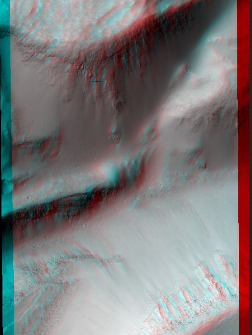
The Dunes of 'Inca City.' Credit: NASA/JPL/University of Arizona.
These pictures require you to grab the 3-D glasses you have handy by your desk (if you don’t have a pair, here’s some great options for buying some) and get a “you-are-there” experience from the HiRISE camera on the Mars Reconnaissance Orbiter. Here, you can virtually tumble down crater walls, hover over steep cliffs, and see how layered bedrock appears from above.
Our lead image is of an area referred to as “Inca City,” the informal name given by Mariner 9 scientists in 1972 to a set of intersecting, rectilinear ridges, which some people thought looked like structures or streets. Even back then scientists thought they might be dunes, but that didn’t keep people from going off the deep end about this region. But the power of HiRISE has revealed these truly are dunes, and in this image you can see some of the seasonal processes as the region goes from winter to spring. As the carbon dioxide frost and ice on the dunes warms, small areas warm and sublimate (turn from solid to gas) faster, creating a speckled surface.
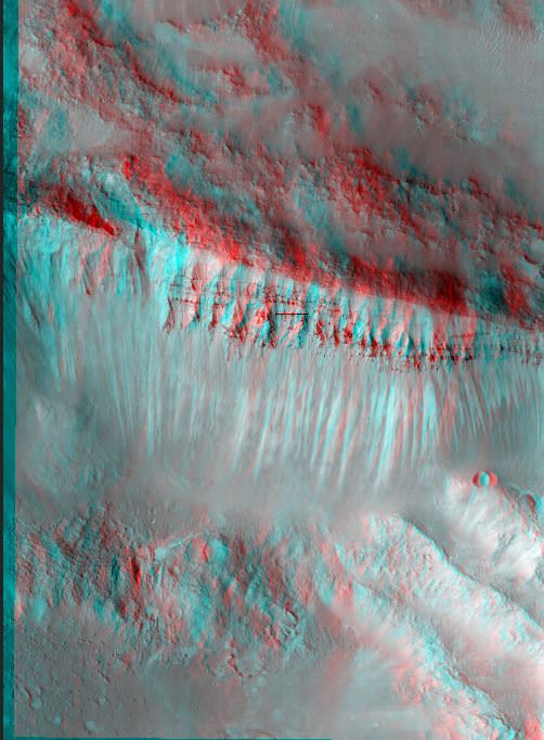
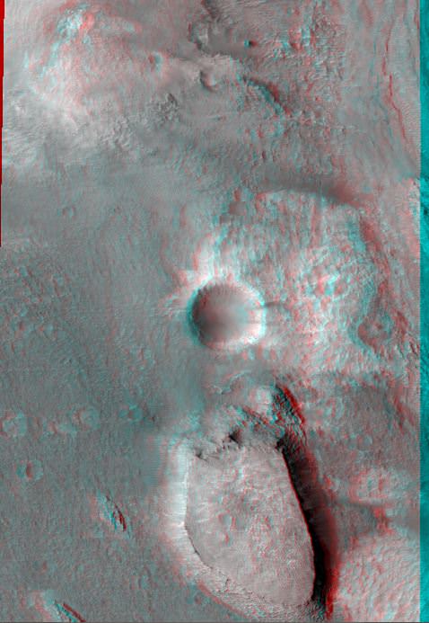
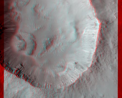
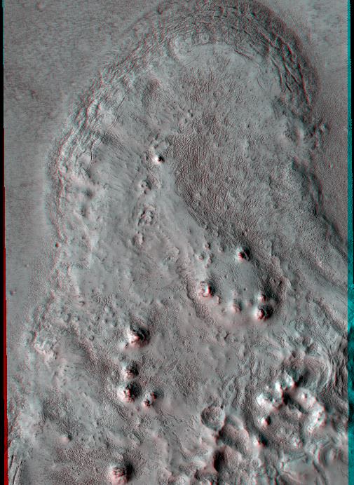
Fresh 4-Kilometer Rayed Crater Northeast of Chimbote Crater. Credit: NASA/JPL/University of Arizona.Cliff with Columnar Jointing. Credit: NASA/JPL/University of Arizona.Central Uplift of a Large Impact Crater. Credit: NASA/JPL/University of Arizona.Buttes and craters: Compositional Diversity in Northern Hellas Region. Credit: NASA/JPL/University of Arizona.Well-Preserved 4-Kilometer impact Crater. Credit: NASA/JPL/University of Arizona.Flow Boundary in Elysium Planitia. Credit: NASA/JPL/University of Arizona.A fissure on Mars named Cerberus Fossae. Credit: NASA/JPL/University of Arizona.Possible Gullies in Graben. Credit: NASA/JPL/University of Arizona.Layered Bedrock on Crater Floor. Credit: NASA/JPL/University of Arizona.
Image Caption: This image of comet ISON (C/2012 S1) ) from NASA’s Deep Impact spacecraft clearly shows the coma and nucleus on Jan. 17/18, 2013 beyond the orbit of Jupiter. See the dramatic new movie sequence below. It combines all 146 80-second clear filter exposures for a total integration time of 11680 seconds (about 3.25 hours). Individual frames were shifted to align the comet at the center before coadding. By keeping the comet centered and adding all of the images together, the stars effectively get smeared so the long streaks are the trails of background stars. Some have called it the “Comet of the Century.” Credit: NASA
NASA’s legendary Deep Impact comet smashing spacecraft has just scored another major coup – Imaging the newly discovered Comet ISON. The comet could possibly become one of the brightest comets ever late this year as it passes through the inner Solar System and swings around the Sun for the very first time in history – loaded with pristine, volatile material just raring to burst violently forth from the eerie surface, and is therefore extremely interesting to scientists. See the Movie below
“Comet ISON was just imaged by Deep Impact out by Jupiter on Jan. 17 and 18,” said Dr. Jim Green, Director of NASA Planetary Sciences at NASA HQ, in an exclusive interview with Universe Today on the campus of Princeton University. “We will try to look at ISON with the Curiosity rover as it flies past Mars, and with other NASA assets in space [along the way]. It should be spectacular!”
“We are all, ops team and science team, thrilled that we were able to make these observations when the comet was still more than 5 AU from the sun,” said Deep Impact Principal Investigator Prof. Michael A’Hearn of the University of Maryland, in an exclusive interview with Universe Today.
ISON could potentially become the next “Great Comet”, according to NASA. Deep Impact is the first spacecraft to observe ISON.
“We are continuing to observe ISON – it is observable from Deep Impact into mid-March 2013,” A’Hearn told me.
ISON will be the 4th comet observed by Deep Impact. On July 4, 2005 the spacecraft conducted a close flyby of Comet Tempel 1 and delivered a comet smashing impactor that made headlines worldwide. Next, it flew near Hartley 2 in Nov. 2010. In January 2012, the spacecraft performed a long distance imaging campaign on comet C/2009 P1 (Garradd). And it has enough fuel remaining for an Asteroid encounter slated for 2020 !
“NASA’s assets at Mars should be able to observe ISON because it will fly really, really close to Mars!” Green said with a big smile – and me too, as he showed me a sneak preview of the brand new Deep Impact movie.
“ISON observations are in the cue for Curiosity from Mars surface and from orbit with NASA’s Mars Reconnaissance Orbiter (MRO) – and we’ll see how it works out. It should be pretty spectacular. We will absolutely try with Curiosity’s high resolution Mastcam 100 camera.”
“LRO (NASA’s Lunar Reconnaissance Orbiter) also has a good shot at ISON.”
“Because of the possibility of observations of for example ISON, with probes like Deep Impact is why we want to keep NASA’s [older] assets viable.”
146 visible light images snapped by Deep Impact just days ago on Jan. 17 and 18, have been compiled into a dramatic video showing ISON speeding through interplanetary space back dropped by distant star fields – see above and below. The new images were taken by the probes Medium-Resolution Imager (MRI) over a 36-hour period from a distance of 493 million miles (793 million kilometers).
“A composite image, combining all of the Jan 17/18 data – after cleaning up the cosmic rays and improving the S/N (signal to noise ratio) clearly shows the comet has a coma and tail,” said Tony Farnham, a Deep Impact research scientist at the University of Maryland, to Universe Today.
Video Caption: This series of images of comet C/2012 S1 (ISON) was taken by the Medium-Resolution Imager (MRI) of NASA’s Deep Impact spacecraft over a 36-hour period on Jan. 17 and 18, 2013. At the time, the spacecraft was 493 million miles (793 million kilometers) from the comet. Credit: NASA/JPL-Caltech/UMD
ISON is a conglomeration of ice and dust and a long period, sun-grazing comet.
“It is coming in from the Solar System’s Oort cloud at the edge of the Solar System”, said Green, and was likely disturbed out of its established orbit by a passing star or other gravitational effects stemming from the Milky Way galaxy. “It will pass within 2.2 solar radii during perihelion and the Sun will either blast it apart or it will survive.”
Despite still being in the outer Solar System and a long distance from the Sun, ISON is already quite “variable” said A’Hearn, and it’s actively spewing material and ‘outgassing”.
The tail extending from the nucleus was already more than 40,000 miles (64,400 kilometers) long on Jan. 18. It’s a science mystery as to why and the Deep Impact team aims to try and determine why.
In addition to imaging, Deep Impact will also begin collecting long range spectral observations in the next week or so to help answer key questions.
“In mid-February, the solar elongation will allow IR (infrared) spectra for a few weeks,” A’Hearn elaborated.
“The 6-7% variability that we observed in the first day of observing shows that there is variable ‘outgassing’, presumably modulated by rotation of the nucleus. We hope to pin down the rotational period with the continuing images.”
“The interesting question is what drives the outgassing!”
Since ISON is still a very great distance away at more than 5 AU, data collection will not be an easy task. The comet is 5.1 AU from the Sun and 5.3 AU from Deep Impact. And the mission could also be imperiled by looming slashes to NASA’s budget if the Federal sequester actually happens in March.
“Getting spectra will be a real challenge because, at these large heliocentric and geocentric distances, the comet is really faint. However, maybe we can test whether CO2 is driving the outgassing,” Ahearn explained.
“Since we have the only facility capable of measuring CO2, it will be important to observe again in our second window in July-August, but that depends on NASA finding a little more money for us.”
“We, both the ops team and the science team, are funded only for the observations through March,” A’Hearn stated.
Although observing predictions for the brightness of comets are sometimes notoriously wrong and they can fade away precipitously, there is some well founded hope that ISON could put on a spectacular sky show for observers in both the northern and southern hemispheres.
The comet will continue to expand in size and grow in brightness as it journeys inward.
“ISON might be pretty spectacular,” said Green. “If things work out it might become bright enough to see during the day and be brighter than the Moon. The tail might be 90 degrees.”
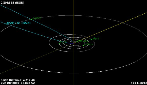
Image caption: This is the orbital trajectory of comet C/2012 S1 (ISON). The comet is currently located just inside the orbit of Jupiter. In November 2013, ISON will pass less than 1.1 million miles (1.8 million kilometers) from the sun’s surface. The fierce heating it experiences during this close approach to the sun could turn the comet into a bright naked-eye object. Credit: NASA/JPL-Caltech
The best times to observe the comets head and growing tail will be from Nov. 2013 to Jan. 2014, if it survives its closest approach to the Sun, known as perihelion, on Nov. 28, 2013 and doesn’t break apart.
There’s no need to worry about doomsday predictions from conspiracy theorists. At its closest approach next Christmas season on Dec. 26, 2013, ISON will pass by Earth at a safe distance of some 40 million miles.
A pair of Russian astronomers only recently discovered the comet on Sept. 21, 2012, using the International Scientific Optical Network’s 16-inch (40-centimeter) telescope near Kislovodsk.
The study of comets has very important implications for understanding the evolution of not just the Solar System but also the origin of life on Earth. Comets delivered a significant portion of the early Earth’s water as well as a range of both simple and complex organic molecules – the building blocks of life.
Image caption. Deep Impact images Comet Tempel 1 alive with light after colliding with the impactor spacecraft on July 4, 2005. CREDIT: NASA/JPL-Caltech/UMD
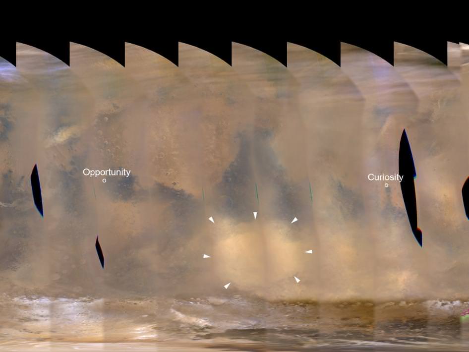
A regional dust storm visible in the southern hemisphere of Mars in this nearly global mosaic of observations made by the Mars Color Imager on NASA’s Mars Reconnaissance Orbiter on Nov. 25, 2012, has contracted from its size a week earlier. Image credit: NASA/JPL-Caltech/MSSS
Good news for the spacecraft sitting on or orbiting Mars: a dust storm on the Red Planet that looked as though it could spread around the entire planet now appears to be abating rather than going global, NASA says.
“During the past week, the regional storm weakened and contracted significantly,” said Bruce Cantor of Malin Space Science Systems, San Diego. Cantor uses the Mars Color Imager camera on NASA’s Mars Reconnaissance Orbiter to monitor storms on the Red Planet.
Recent images and data from the Environmental Monitoring Station (REMS) on the Curiosity rover have also shown a hazy atmosphere and air pressure changes in the vicinity of Gale Crater.
Part of gigantic panorama from Curiosity, showing an increasingly hazy view off in the distance, likely because of a dust storm. Credit: NASA/JPL/MSS, with image editing by Stuart Atkinson. See the full panorama here.
“We are getting lots of good data about this storm,” said Mark Richardson of Ashima Research, Pasadena, California, a co-investigator both on REMS and on the Mars Reconnaissance Orbiter’s Mars Climate Sounder instrument, which has been detecting widespread effects of the current storm on atmospheric temperatures.
Here’s a look at the growing dust storm from the Mars Color Imager on NASA’s Mars Reconnaissance Orbiter on Nov. 18, 2012 to compare with the lead image:
Credit:NASA/JPL-Caltech/MSSS
Researchers anticipate that the unprecedented combination of a near-equatorial weather station at ground level, and daily orbital observations during Mars’ dust-storm season, may provide information about why some dust storms grow larger than others.
This is good information to have for any potential future human visitors to Mars.
Observations by NASA’s Mars Reconnaissance Orbiter have detected carbon-dioxide snow clouds on Mars and evidence of carbon-dioxide snow falling to the surface. Image credit: NASA/JPL-Caltech
In 2008, we learned from the Phoenix Mars lander that it snows in Mars northern hemisphere — perhaps quite regularly – from clouds made of water vapor. But now, Mars Reconnaissance Orbiter data has revealed the clearest evidence yet of carbon-dioxide snowfalls on Mars. Scientists say this is the only known example of carbon-dioxide snow falling anywhere in our solar system.
“These are the first definitive detections of carbon-dioxide snow clouds,” said Paul Hayne from the Jet Propulsion Laboratory, lead author of a new study published in the Journal of Geophysical Research. “We firmly establish the clouds are composed of carbon dioxide — flakes of Martian air — and they are thick enough to result in snowfall accumulation at the surface.”
Scientists have known for decades that carbon-dioxide exists in ice in Mars’ seasonal and permanent southern polar caps. Frozen carbon dioxide, sometimes called “dry ice” here on Earth, requires temperatures of about -125 Celsius (- 193 degrees Fahrenheit), which is much colder than needed for freezing water.
Even though we like to think Mars is a lot like Earth, findings like this remind us that Mars is indeed quite different. But just as the water-based snow falls during the winter in Mars’ northern hemisphere, the CO2 snowfalls occurred from clouds around the Red Planet’s south pole during winter in the southern hemisphere.
“Swiss Cheese Terrain” on Mars South Pole residual CO2 ice cap. Credit: NASA/JPL/University of Arizona
Hayne and six co-authors analyzed data gained by looking at clouds straight overhead and sideways with the Mars Climate Sounder, one of six instruments on the Mars Reconnaissance Orbiter. This instrument records brightness in nine wavebands of visible and infrared light as a way to examine particles and gases in the Martian atmosphere. The analysis was conducted while Hayne was a post-doctoral fellow at the California Institute of Technology in Pasadena.
The data provide information about temperatures, particle sizes and their concentrations. The new analysis is based on data from observations in the south polar region during southern Mars winter in 2006-2007, identifying a tall carbon-dioxide cloud about 500 kilometers (300 miles) in diameter persisting over the pole and smaller, shorter-lived, lower-altitude carbon dioxide ice clouds at latitudes from 70 to 80 degrees south.
“One line of evidence for snow is that the carbon-dioxide ice particles in the clouds are large enough to fall to the ground during the lifespan of the clouds,” co-author David Kass of JPL said. “Another comes from observations when the instrument is pointed toward the horizon, instead of down at the surface. The infrared spectra signature of the clouds viewed from this angle is clearly carbon-dioxide ice particles and they extend to the surface. By observing this way, the Mars Climate Sounder is able to distinguish the particles in the atmosphere from the dry ice on the surface.”
Mars’ south polar residual ice cap is the only place on the Red Planet where frozen carbon dioxide persists on the surface year-round. Just how the carbon dioxide from Mars’ atmosphere gets deposited has been in question. It is unclear whether it occurs as snow or by freezing out at ground level as frost. These results show snowfall is especially vigorous on top of the residual cap.
“The finding of snowfall could mean that the type of deposition — snow or frost — is somehow linked to the year-to-year preservation of the residual cap,” Hayne said.
Clouds on Mars are producing snow. Credit: NASA/JPL-Caltech/University of Arizona/Texas A&M University
In 2008, science teams from the Phoenix mission were able to observe water-ice clouds in the Martian atmosphere and precipitation that fell to the ground at night and sublimate into water in the morning. Phoenix scientist James Whiteway and his colleagues said that clouds and precipitation on Mars play a role in the exchange of water between the ground and the atmosphere and when conditions are right, snow falls regularly on Mars.
“Before Phoenix we did not know whether precipitation occurs on Mars,” Whiteway said. “We knew that the polar ice cap advances as far south as the Phoenix site in winter, but we did not know how the water vapor moved from the atmosphere to ice on the ground. Now we know that it does snow, and that this is part of the hydrological cycle on Mars.”
It will be interesting to follow up on this discovery and learn more about Mars CO2 cycle and how it might affect the Martian atmosphere and surface processes.
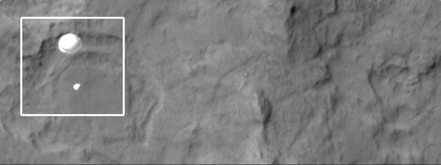
The HiRISE team has outdone themselves this time. Using their incredible instrument, the High Resolution Imaging Science Experiment, they have captured an absolutely amazing image of the Curiosity rover, descending on a parachute through Mars’ atmosphere.
“Nailed it!” Tweeted Christian Schaller of the HiRISE team. “My goodness, @MarsCuriosity you look pretty.”
Schaller told Universe Today that the MSL Navigation team, the MRO Navigation team and the MRO FET (flight engineering team) “seriously rock. Seriously.”
The planning by those teams made this image possible.
Schaller is the software developer responsible for the primary planning tools the MRO and HiRISE targeting specialists and science team members use to plan their images.
“The Mars background looks a little blurry or smeared because we set up the timing to capture Curiosity, not the Martian surface,” Schaller said via email after the image was released at the press conference from JPL on Monday morning.
The image was set up so that as MSL was descending, MRO “slewed” the HiRISE field of view across the expected descent path. But obviously, MRO didn’t have to slew too much. “We were almost directly overhead, and had a very, very small angle to take the image,” said HiRISE team member Sarah Malkovich at the press conference. “MRO was essentially overhead.”
HiRISE Principal Investigator Alfred McEwen said before the landing that they expected only a 60% chance of success.
The parachute appears fully inflated and performing perfectly. Details in the parachute such as the band gap at the edges and the central hole are clearly visible. The cords connecting the parachute to the backshell cannot be seen, although they were seen in the image of Phoenix descending, perhaps due to the difference in lighting angles.
The bright spot on the backshell containing MSL might be a specular reflection off of a shiny area. MSL was released from the backshell sometime after this image was acquired.
This view is one product from an observation made by HiRISE targeted to the expected location of MSL about 1 minute prior to landing. It was captured in HiRISE CCD RED1, near the eastern edge of the swath width (there is a RED0 at the very edge). This means that MSL was a bit further east or downrange than predicted.
The image scale is 33.6 cm/pixel.
MRO was 340 km away from Curiosity when the image was taken, and that is line of sight distance, said Malkovich. “HiRISE has taken over 120 pictures of Gale Crater in preparation for MSL’s mission, but I think this is the coolest one,” she said.
McEwen said more details and image products will be available and we will post them as soon as they are available.
This animation shows how HiRISE planned to capture MSL’s descent:
Malkovich said that the HiRISE team already has plans to take images of Curiosity sitting on the surface of Mars later this week that will be of higher resolution than the descent image.
Mars Reconnaissance Orbiter's High Resolution Imaging Science Experiment (HiRISE) camera captured this image of Phoenix hanging from its parachute as it descended to the Martian surface. Credit: NASA/JPL/University of Arizona.
[/caption]
Note: This article was updated on Aug. 3 with additional information.
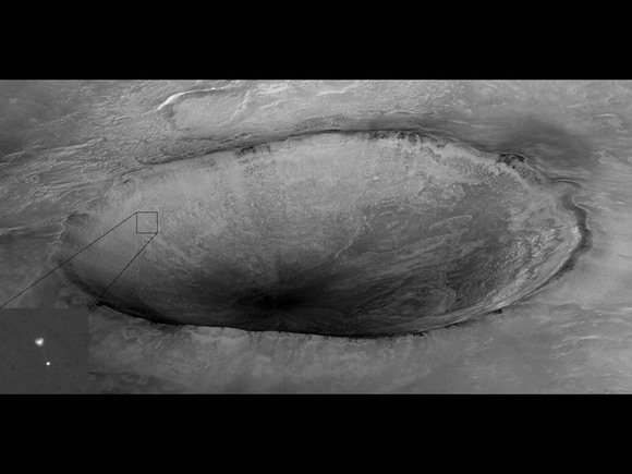
The HiRISE camera crew on the Mars Reconnaissance Orbiter will attempt an audacious repeat performance of the image above, where the team was able to capture an amazing shot of the Phoenix lander descending on a parachute to land on Mars’ north polar region. Only this time it will try to focus on the Mars Science Laboratory’s Curiosity rover descending to touch down in Gale Crater. It will be all or nothing for the HiRISE team, as they get only one shot at taking what would likely be one of the most memorable images of the entire mission for MRO.
“We’re only making one attempt on MSL here,” Christian Schaller of the HiRISE team told Universe Today. “The EDL (Entry, Descent and Landing) image is set up so that as MSL is descending, MRO will be slewing the HiRISE field of view across the expected descent path. The plan is to capture MSL during the parachute phase of descent.”
Schaller is the software developer responsible for the primary planning tools the MRO and HiRISE targeting specialists and science team members use to plan their images.
Last December, when Universe Today learned of this probable imaging attempt, HiRISE Principal Investigator Alfred McEwen confirmed for us that, indeed, the team was working to make it happen. The preferred shot would be to “capture the rover hanging from the skycrane, but the timing may be difficult,” McEwen said.
It would take an impeccable – and fortuitous – sense of timing to get that shot, but since MSL’s EDL won’t happen on a precisely exact timetable, the HiRISE team will take their one shot and see what happens.
“We’ve been gradually updating the exact timing of the sequence over the past couple of weeks as the MSL navigation team, the MRO navigation team and the MRO flight engineering team refines that descent path and MRO slew,” Schaller said via email, “and we think we’ve pretty much got it nailed down at this point. I think it’s a real testament to NASA and its partners that we can even think about doing this.”
HiRISE will actually be taking two images, but the first is a “throwaway” warmup image taken about 50 minutes prior to MSL’s descent, designed to heat the camera’s electronics up to the preferred temperature for getting good image data.
“The warmup image we’re taking is a long-exposure throwaway that we’re taking on the night side of Mars,” Schaller explained. “It’s a 5,000 microsecond per line exposure, compared to a more typical 100 microsecond per line exposure during normal surface imaging. These warmup data will be useless, and we don’t even bother sending them back to Earth; we just dump them from the MRO filesystem once the exposure is complete.”
Schaller said the warmup image starts executing at 04:17 UTC/9:17 PM PDT. The real image starts executing at 05:09 UTC/10:09 PM PDT, centered on 10:16 PM as the time MSL and MRO navigation teams have determined MSL will pass through HiRISE’s field of view.
This image will be an approximately 500 microseconds per line exposure, to match the MRO’s slew rate.
Caption: Artist impression of MRO orbiting Mars. Credit: NASA
UPDATE (Aug. 3): In checking with McEwen, he said that Mars Express and Odyssey are NOT planning to image the descent, but they are supporting EDL via UHF relay, and the plans to use CTX has been dropped.
“HiRISE plans are to definitely attempt the image, unless there is a late upset to the MRO spacecraft,” McEwen said via email on August 3. “The engineers estimate we have a 60% chance of capturing MSL in our image.”
MRO’s Context Camera (CTX) will also be attempting to image Curiosity’s descent, as will NASA’s Mars Odyssey and ESA’s Mars Express and all the spacecraft have been performing special maneuvers to be aligned in just the right place – nearby to MSL’s point of entry into Mars’ atmosphere.
While Odyssey and Mars Express’ cameras may not have the resolving power to capture MSL itself, the powerful HiRISE camera does. However, it has a narrower field of view, so as much skill and planning as this requires, the team will need a little luck, too. But there’s also the CTX.
“CTX has a much larger field of view and will likely capture it,” McEwen said, “but at 20X lower resolution than HiRISE, which should still be good enough to detect the parachute.”
For those concerned about the fuel required for all these orbiters to reposition themselves just to take a few pictures, the expenditure is nothing that isn’t required anyway. All the spacecraft need to be in position to support MSL during the critical EDL event, and the images are pure extra-benefit, if not an incredible exercise for the imaging teams.
So while we’ll all be crossing our fingers for a successful landing for Curiosity, I’m on my way to find a rabbit’s foot or 4-leaf clover for HiRISE.
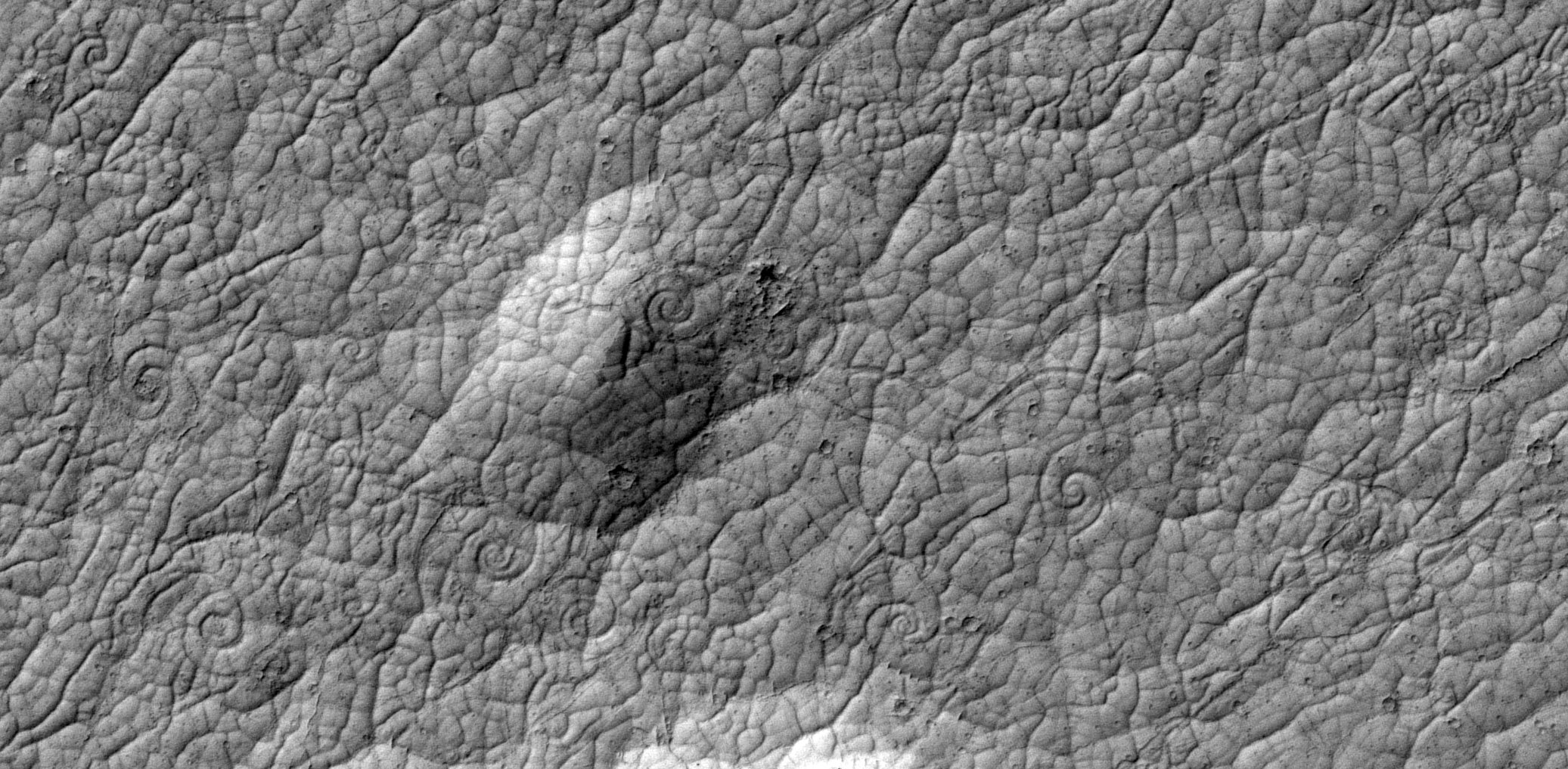
Cooling lava on Mars can form patterns like snail shells when the lava is pulled in two directions at once. Such patterns, rare on Earth, have never before been seen on Mars. This image, with more than a dozen lava coils visible, shows an area in a volcanic region named Cerberus Palus that is about 500 meters (1640 feet) wide. Credit: NASA
[/caption]
Strange coiling spiral patterns have been found on Mars surface by a graduate student who was doing what many of us enjoy: looking through the high-resolution images from the HiRISE camera on the Mars Reconnaissance Orbiter. Similar features have been seen on Earth, but this is the first time they have been identified on Mars. However, on Mars, these features, called lava coils, are supersized. “On Mars the largest lava coil is 30 meters across – that’s 100 feet,” said Andrew Ryan from Arizona State University. “That’s bigger than any known lava coils on Earth.”
The lava coils resemble snail or nautilus shells. Ryan has found about 269 of these lava coils just in one region on Mars, Cerberus Palus. 174 of them swirl in a clockwise-in orientation, 43 are counterclockwise, and 52 of the features remain unclassified due to resolution limits.
A small lava coil on pahoehoe flow, Kilauea Volcano, Hawai`i(see the pocket knife for scale.) Credit: W.W. Chadwick
On Earth, lava coils can be found on the Big Island of Hawaii, mainly on the surface of ropey pahoehoe lava flows. They usually form along slow-moving shear zones in a flow; for example, along the margins of a small channel, and the direction of the flow can be determined from a lava coil.
“The coils form on flows where there’s a shear stress – where flows move past each other at different speeds or in different directions,” said Ryan. “Pieces of rubbery and plastic lava crust can either be peeled away and physically coiled up – or wrinkles in the lava’s thin crust can be twisted around.”
Similarly, Ryan said scientists have documented the formation of rotated pieces of oceanic crust at mid-ocean ridge spreading centers.
Newer lava lying between two older plates of rough, hardened lava was still hot and plastic enough to form coils and spirals when the plates slid past one another. This image shows an area about 360 meters (1200 feet) wide in Cerberus Palus. Credit: NASA
But Ryan and the co-author on the paper, Phil Christiansen, Principal Investigator for the Thermal Emission Imaging Spectrometer on the Mars Odyssey spacecraft, are certain water has nothing to do with the formation of the lava coils on Mars.
“There are no known mechanisms to naturally produce spiral patterns in ice-rich environments on the scale and frequency observed in this area,” they wrote in their paper. “It is also unlikely that ice-rich patterned regolith, which takes decades to centuries to develop, could fracture and drift. The lava coils and drifting polygonal and platy-ridge lava crust described above are therefore most consistent with known volcanic analogs, rather than ice-related processes.”
These features are probably quite young, formed 1.5 to 200 million years ago in Mars’ late Amazonian period when the planet was volcanically active.
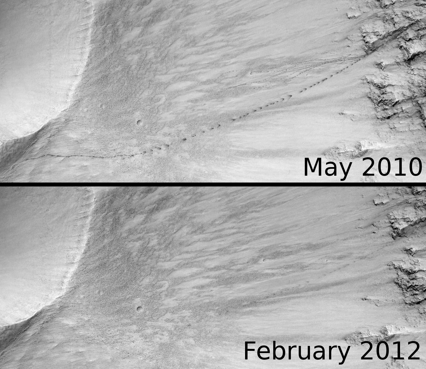
Proof that Mars is an ever-changing world: a view from the Mars Reconnaissance Orbiter in 2010 showed tracks from a rolling boulder; in an image of the same region 1 Mars year later the tracks have dissapeared. Credit: NASA/JPL/University of Arizona
[/caption]
More proof that Mars is an ever-changing world: In 2010, the Mars Reconnaissance Orbiter’s HiRISE camera spotted evidence that a boulder had rolled down an incline in a crater. The boulder left a visible track in the Martian regolith big enough to be spotted by MRO. But just one Martian year later, the tracks are gone, erased from existence.
“This is most likely due to the fine bright dust that is transported in the atmosphere falling down and re-covering the dark markings,” wrote Ross A. Beyer on the HiRISE site.
Beyer said the boulder tracks are much darker because as the boulders roll “they set off miniature dust avalanches. The bright, fine dust slides away, leaving a darker, larger grained dust underneath.”
How do boulders start moving on Mars? The boulders were disturbed in some way, breaking them loose from the crater edge, and there are two different possibilities. One, is that a meteorite impact or other tremor shook the boulder loose. Another possibility, as in the case of avalanches MRO has seen on Mars, the spring thawing of frozen carbon dioxide which forms during the Martian winter can cause rocks and debris to break loose from a cliff or incline.
Mars is certainly not the dead world we once thought it was, and the power of HiRISE keeps revealing a changing, unpredicatable landscape.
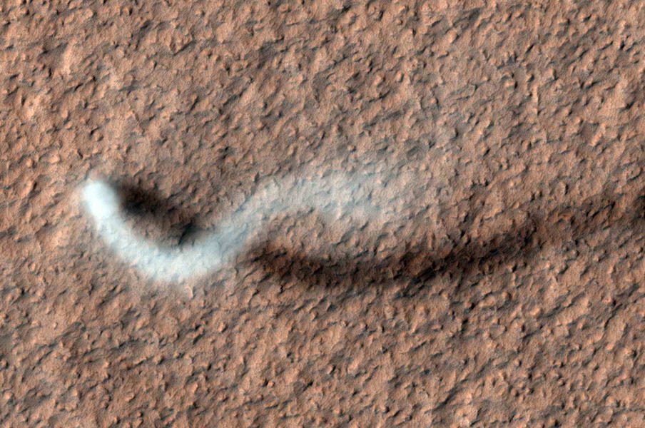
The folk at JPL have kindly put together an animation of the gigantic Martian dust devil spotted by the Mars Reconnaissance Orbiter. The dust devil is roughly 20 kilometers (12 miles) high, churning through the Amazonis Planitia region of northern Mars, and this shows what the tall but thin dust devil would look like if you were observing it as you hovered around in your Mars helicopter or balloon.
A towering dust devil, casts a serpentine shadow over the Martian surface in this image acquired by the High Resolution Imaging Science Experiment (HiRISE) camera on NASA's Mars Reconnaissance Orbiter. Image credit: NASA/JPL-Caltech/Univ. of Arizona
[/caption]
Mars orbiters, rovers and landers have all captured devils in action before. But this latest shot is a whopper (to speak in the vernacular of the peasantry…*) – not to mention incredibly awesome! The HiRISE camera (High Resolution Imaging Science Experiment) on the Mars Reconnaissance Orbiter has taken an image of an afternoon whirlwind on Mars lofting a twisting column of dust more than 800 meters (about a half a mile) high, with the dust plume about 30 meters or yards in diameter.
HiRISE captured the image on Feb. 16, 2012, in the Amazonis Planitia region of northern Mars. Evidence of many previous whirlwinds, or dust devils, are visible as streaks on the dusty surface shown in the image.
Scientists from JPL said the active dust devil and its delicate arc were produced by a westerly breeze partway up its height.
Just like on Earth, winds on Mars are powered by solar heating. However, Mars is now farthest from the Sun, and even though the exposure to the Sun’s rays is now less, even so, the dust devils are moving dust around on Mars’ surface.
Dust devils occur on Earth as well as on Mars. They are spinning columns of air, made visible by the dust they pull off the ground. Unlike a tornado, a dust devil typically forms on a clear day when the ground is heated by the sun, warming the air just above the ground. As heated air near the surface rises quickly through a small pocket of cooler air above it, the air may begin to rotate, if conditions are just right.
MRO and HiRISE continue to provide insights into the planet’s ancient environments and how processes such as wind, meteorite impacts and seasonal frosts continue to affect the Martian surface today. This mission – operating since 2006 in Mars orbit – has returned more data about Mars than all other orbital and surface missions combined.


![HRI_937_1[1]](https://www.universetoday.com/wp-content/uploads/2013/02/HRI_937_11-580x580.jpg)