More Views of Hurricane Irene from Space: It’s Big

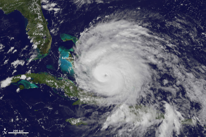
A view of Hurricane Irene taken by the GOES satellite at 2:55 p.m. Eastern Daylight Time on August 24, 2011. Credit: NASA

Here are several different views of Hurricane Irene: from 230 miles above the Earth, cameras on the International Space Station captured several views of powerful Hurricane Irene as it churned over the Bahamas at 3:10 p.m. EDT on August 24, 2011. Irene is moving to the northwest as a Category 3 hurricane, packing winds of 120 miles an hour. Irene is expected to strengthen to a Category 4 storm as it heads toward the Outer Banks of North Carolina, the Eastern Seaboard and the middle Atlantic and New England states.

See more from other satellites, below:

[/caption]

This view of Irene was taken by the GOES satellite at 2:55 p.m. Eastern Daylight Time on August 24, 2011. Irene now has a distinct eye and the clouds spiraling around the center are becoming more compact. The image also shows how large Irene has become, measuring several hundred kilometers across.
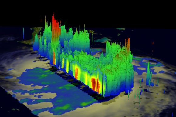
A three dimensional perspective of Irene, showing rainfall. Credit: NASA/TRMM satellite

This image was taken on August 22, but is a really nifty, three-dimensional view of the precipitation from Irene, as seen by the Tropical Rainfall Measuring Mission. It reveals an area of deep convection (shown in red) near the storm’s center where precipitation-sized particles are being carried aloft. These tall towers are associated with strong thunderstorms responsible for the area of intense rain near the center of Irene seen in the previous image. They can be a precursor to strengthening as they indicate areas within a storm where vast amounts of heat are being released. This heating, known as latent heating, is what is drives a storm’s circulation and intensification.

Here’s the latest view of Irene from WeatherBug:

View of Irene from WeatherBug.com

As of 8 a.m. EDT on August 25, Hurricane Irene was located near 25.5 N and 76.5 W, or 65 miles east-southeast of Nassau, Bahamas. This places it about 670 miles south of Cape Hatteras, N.C. Irene`s top sustained winds remain at 115 mph, and is moving to the northwest at 13 mph.

Sources: NASA Multimedia,

Apocalyptic Time-Lapse Video of Massive Phoenix Dust Storm

This isn’t space and astronomy-related, but this video of the massive dust storm that swept through the Phoenix area yesterday is just amazing, if not apocalyptic! Mike Olbinski, a photographer from the area shot this timelapse, and on his website says, “There are really not many words to describe this dust storm, or what we call it here (and they also do in places like the Sahara Desert)…a haboob. This was a haboob of a lifetime. I’ve lived in Phoenix for my entire 35 years of existence and have never seen anything like this before. It was incredible.”
Continue reading “Apocalyptic Time-Lapse Video of Massive Phoenix Dust Storm”

Satellite Looks Down the Eye of Erupting Nabro Volcano

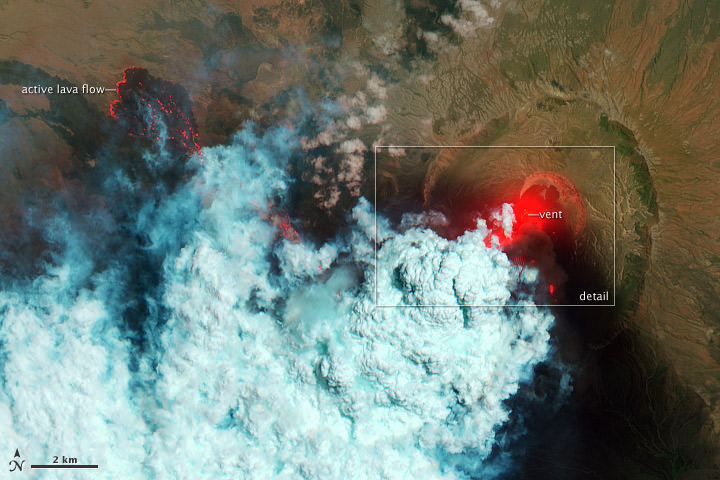
This false color satellite image shows active lava flows of the Nabro volcano in Eritrea on June 24, 2011. Credit: the Advanced Land Imager (ALI) aboard the Earth Observing-1 (EO-1) satellite.

[/caption]

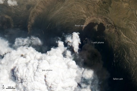
Wow! What an amazing and detailed top-down view of an active volcano! This is the Nabro Volcano, which has been erupting since June 12, 2011. It sits in an isolated region on the border between Eritrea and Ethiopia and satellite remote sensing is currently the only reliable way to monitor the ongoing eruption, according to the NASA Earth Observatory website. The bright red portions of the false-color image (above) indicate hot surfaces. See below for a zoomed-in look. Both images were taken by the Advanced Land Imager (ALI) aboard the Earth Observing-1 (EO-1) satellite.


This natural-color image shows a close-up view of the volcanic plume and eruption site of the Nabro volcano. Credit: the Advanced Land Imager (ALI) aboard the Earth Observing-1 (EO-1) satellite

Robert Simmon of the NASA Earth Observatory website describes the scenes:

Hot volcanic ash glows above the vent, located in the center of Nabro’s caldera. To the west of the vent, portions of an active lava flow (particularly the front of the flow) are also hot. The speckled pattern on upstream portions of the flow are likely due to the cool, hardened crust splitting and exposing fluid lava as the flow advances. The bulbous blue-white cloud near the vent is likely composed largely of escaping water vapor that condensed as the plume rose and cooled. The whispy, cyan clouds above the lava flow are evidence of degassing from the lava.

The natural-color image (lower) shows a close-up view of the volcanic plume and eruption site. A dark ash plume rises directly above the vent, and a short, inactive (cool) lava flow partially fills the crater to the north. A gas plume, rich in water and sulfur dioxide (which contributes a blue tint to the edges of the plume) obscures the upper reaches of the active lava flow. Black ash covers the landscape south and west of Nabro.

Limited reports from the region say that at least 3,500 people and up to 9,000 that have been affected by the eruption, with at least 7 deaths caused by the erupting volcano. The ash plume has also disrupted flights in the region.

For more information see NASA’s Earth Observatory website, and BigThink

Astounding Satellite Views of the Puyehue-Cordón Ash Plume

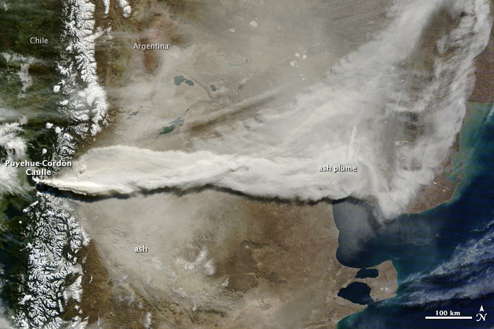
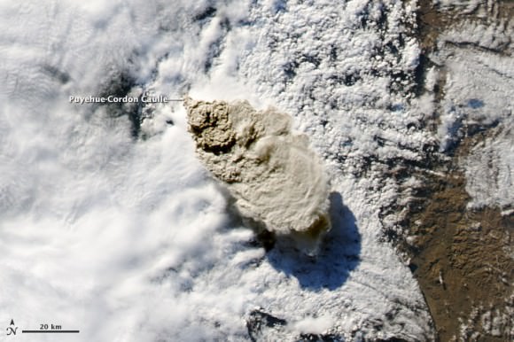
A gigantic plume of ash from the Puyehue-Cordón Volcano in Chile spreads across South America. This image was taken on June 13, 2011 by the Moderate Resolution Imaging Spectroradiometer (MODIS) on the Terra satellite. Credit: NASA and courtesy Jeff Schmaltz, MODIS Rapid Response Team at NASA GSFC.

[/caption]

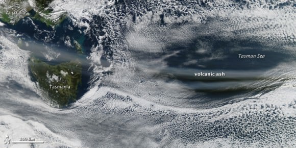
An incredible amount of ash is being spewed from the erupting Puyehue-Cordón Volcano Complex in Chile. This image, taken by the Moderate Resolution Imaging Spectroradiometer (MODIS) on the Terra satellite on June 13, 2011, shows a large plume of volcanic ash blowing about 780 kilometers east and then northeast over Argentina. A plume of volcanic ash from this eruption disrupted air traffic as far away as New Zealand on June 13. See images below of how far the ash has traveled in the atmosphere, a half a world away.


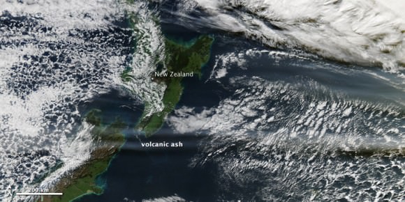
The Moderate Resolution Imaging Spectroradiometer (MODIS) on the Aqua satellite acquired the two images below of the Chilean ash plume on June 13, 2011 showing that a concentrated plume was visible more than half a world away. The first image shows the ash plume over southern Australia and the Tasman Sea, while the second image provides a view farther east over New Zealand and the South Pacific Ocean.

The Chilean ash plume over southern Australia and the Tasman Sea on June 13, 2011. Credit: NASA/MODIS on the Aqua Satellite.
The Chilean volcano ash plume over NewZealand and the South Pacific Ocean. Credit: NASA/MODIS on the Aqua satellite.

NASA’s Earth Observatory website says that although the intensity of the eruption has decreased since the initial eruption, the volcano’s activity is holding steady. The plume reached between 4 and 8 kilometers in altitude on June 13, its height varying with the intensity of the eruptive episode throughout the day.

Here’s how the volcano looked back on June 4, 2011 when it began spewing ash 45,000 feet (14,000 meters) into the air. The Moderate Resolution Imaging Spectroradiometer (MODIS) on the Aqua satellite captured this natural-color image shortly after the eruption began:

Chile’s Puyehue-Cordón Caulle volcano on June 4, 2011. Credit: NASA/Aqua - MODIS

See more images and data on this volcano at the NASA Earth Observatory Natural Hazards website.

You can follow Universe Today senior editor Nancy Atkinson on Twitter: @Nancy_A. Follow Universe Today for the latest space and astronomy news on Twitter @universetoday and on Facebook.

Joplin, Missouri Tornado Seen From Space

This video from NOAA’s GOES geostationary satellite shows the development of the supercell storm that produced the devastating tornado that struck Joplin, Missouri. Here you can see the storm develop over Missouri, Oklahoma, Kansas state lines on May 22, 2011 between 12:44pm to 7:15pm CDT. This was part of the great wave of severe storms that swept across the central United States, with tornado warnings from Minneapolis to Dallas. The most damaging storm struck Joplin at 5:30 pm local time (2230 UTC), killing at least 116 people.

Below is imagery from the Tropical Rainfall Measuring Mission satellite (TRMM).
Continue reading “Joplin, Missouri Tornado Seen From Space”

Mississippi River Flooding As Seen from the Space Station

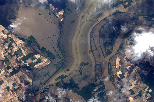
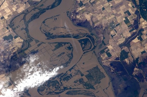
Flood water from the Mississippi river near New Madrid, Missouri, as seen by Paolo Nespoli on board the International Space Station. Credit:ESA/NASA

[/caption]

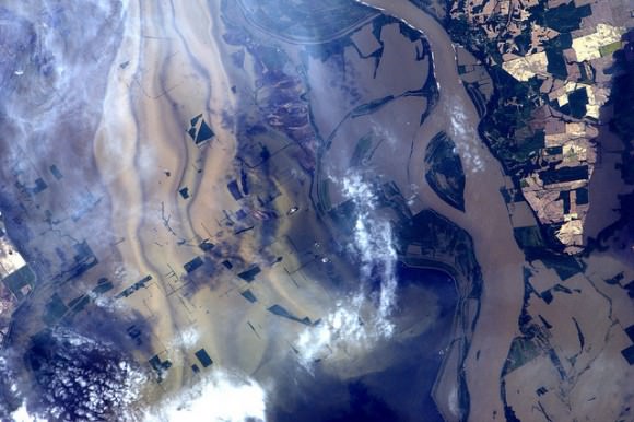
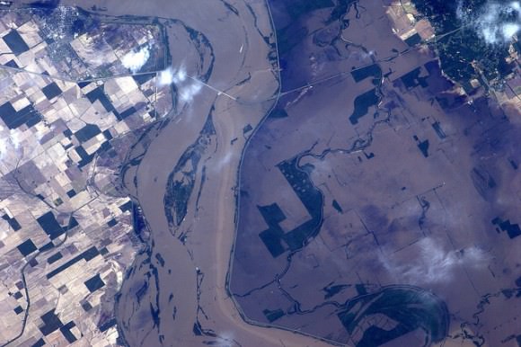
Big Muddy, as the Mississippi River is known, looks especially big and muddy these days with record flooding occurring along the largest river in the US. The Mississippi has risen to levels not seen in since the 1920’s and 30’s, fed by heavy spring rains and the spring thaw from heavy snows in the northern US this winter. Here are some new images taken by International Space Station astronaut Paolo Nespoli, which show surprising detail of how the river has spread across farmland and through cities and towns. The image above shows the area around New Madrid, Missouri, along the border of Kentucky.

Flooding near Ridgely, Tennessee. Credit: ESA/NASA

In this image, levees are visible which are containing the flood near Ridgely, Tennessee.

Here, flooded areas from the Mississippi is about 5 miles wide. Credit: ESA/NASA
Flooding near Caruthersville, Missouri. Farmland, roads and bridges are under water. Credit: ESA/NASA

Last week, the US Army Corps of Engineers opened floodways in Missouri to keep pressure off levees protecting the town of Cairo, Illinois, flooding thousands of acres of farmland. This week, the Corp is preparing to flood up to three million acres in southern Louisiana in hopes of protecting large cities along the Mississippi River such as Baton Rouge and New Orleans, Louisiana. More than 25,000 people are preparing to leave the region before the spillways would be opened.

See more images from Nespoli on his Flickr page.

Satellite Imagery Shows How Tornadoes Slashed Across Alabama, Mississippi

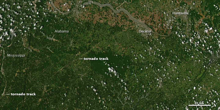
This image shows the path of exposed ground left in the wake of an EF5 tornado in Mississippi. Credit: MODIS Rapid Response Team at NASA GSFC.

[/caption]

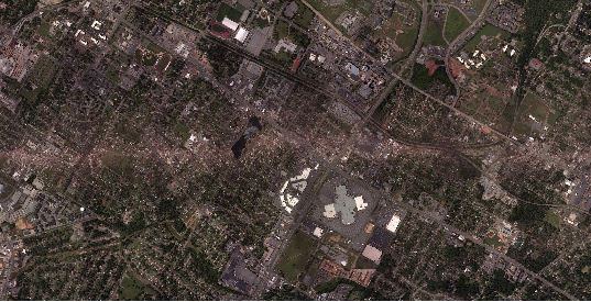
Some extraordinary satellite and radar imagery shows how the deadly tornado supercell slashed through Alabama and Mississippi last week, as in the image above, leaving a gash of exposed ground and destruction that is visible from space. The latest reports indicate fatalities from the outbreak now exceed 342 people, and according to the Washington Post, this is the most people killed by tornadoes in a two-day period since April 5-6, 1936 when 454 people died. The image was taken by the Moderate Resolution Imaging Spectroradiometer (MODIS) on NASA’s Aqua satellite on April 28. See more imagery below.

Part of the path of a 12-mile swath of destruction in Alabama from an EF4 tornado on April 27. Click to see the entire swath taken by a NOAA satellite. Credit: NOAA

The National Weather Service said an EF4, with winds around 175 miles per hour, created a 12-mile-long track of destruction. This tornado caused more than 20 deaths.

Radar sequence of tornado supercell thunderstorms that tracked from western Mississippi into southwest North Carolina. Credit: NCAR, Brian Tang.

This image is pretty amazing: it is a radar montage of the supercell showing some of the 150 tornadoes that were reported on April 27 and 28, 2011. This cell traveled about 450 miles and lasted over 8 hours.

This animation from the NASA Earth Observatory team starts on April 26 and runs through the morning of April 28. It shows a relatively stable mass of cold air—visible as a swirl of more-or-less continuous clouds—rotates in the north along the top of the image, and meanwhile, moist air pushes north and west from the Atlantic Ocean and Gulf of Mexico. The two air masses collide and generate severe weather, but the bad weather also was amplified by the jet stream on April 27, which helped generate the lines of intense thunderstorms and tornadoes.

Sources: NASA Earth Observatory, Washington Post, NOAA

Japan Quake May Have Shortened Earth Days, Moved Axis

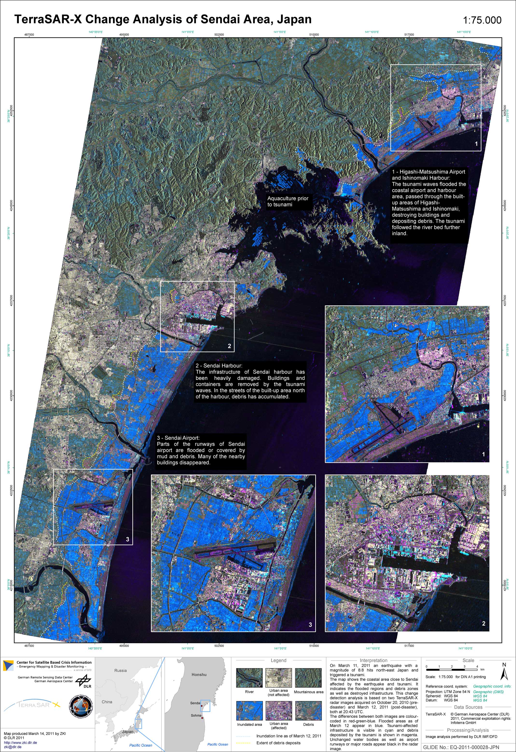
TerraSAR-X Change Analysis of Sendai Area, Japan. Map show coastal area of Sendai effected by 9,0 magnitude Earthquake that triggered ensuing destructive Tsunami. Credit: Deutsches Zentrum fur Luft- und Raumfahrt (DLR) - German Aerospace Center

[/caption]

The terribly destructive magnitude 9.0 earthquake which struck Japan on March 11, may have had another effect – Shortening the length of each Earth day and shifting its axis. Did you notice any change ?

Well according to NASA, the changes are so small that you won’t notice the difference.

Based on initial calculations conducted by Richard Gross, a research scientist at NASA’s Jet Propulsion Laboratory, the earthquake should have caused Earth to rotate just slightly faster, shortening the length of the day by about 1.8 microseconds (a microsecond is one millionth of a second), according to a statement released by NASA.

A reader posted this link to before and after photos

Gross used complex modeling and estimates of fault slippage to perform a preliminary theoretical calculation of how the earth’s rotation may have been affected.

Calculations by Gross also indicate that the position of Earth’s figure axis could have shifted by about 17 centimeters (6.5 inches), towards 133 degrees east longitude. The figure axis is the axis about which Earth’s mass is balanced.
Earth’s figure axis is therefore different and offset from the north-south axis by about 10 meters.

“This shift in Earth’s figure axis will cause Earth to wobble a bit differently as it rotates, but it will not cause a shift of Earth’s axis in space-only external forces such as the gravitational attraction of the sun, moon and planets can do that,” according to the NASA statement.

The estimates for both the shortening in the Earth’s rotation and shift in the figure axis are preliminary and will very likely change as more data is collected and the calculations are refined.

The March 11 earthquake was the fifth largest since 1900. So far, over 4000 people are confirmed dead and the overall death total may exceed 10,000.

Several heavily damaged nuclear reactors at the Fukushima plant are in danger of meltdown as hero workers inside put their lives on the line to avoid a catastrophic failure and try to prevent the spread of lethal radiation.

This view of Earth comes from NASA's Moderate Resolution Imaging Spectroradiometer aboard the Terra satellite

Previously, Gross had calculated the affects of the magnitude 8.8 Chilean quake in 2010 and found them to be slightly smaller compared to the Japanese quake. He calculated a shortening in the length of day of about 1.26 microseconds and shifting of Earth’s figure axis of about 8 centimeters (3 inches). These affects are dependent on the magnitude of the quake, exactly where it is located as well as how the particulars of how the fault slips.

In fact, Earth’s rotation is changing all the time as a result of continual changes in atmospheric winds and oceanic currents and these effects are about 550 times larger than the Japanese earthquake.

“Over the course of a year, the length of the day increases and decreases by about a millisecond,” says Gross. Indeed, the effects of earthquakes on changing rotation are so tiny that they are smaller than the margin of error in the measurements themselves.

By comparison, measurements of the figure axis are much more reliable and meaningful. Changes to the figure axis can be accurately measured to within about 5 centimeters. This means that the estimated 17 centimeter shift from the Japanese quake may be real after accounting for the effects of the atmospheric winds and ocean currents. Further research is needed as more data are collected and analyzed.

“These changes in Earth’s rotation are perfectly natural and happen all the time. People shouldn’t worry about them,” said Gross.

Source: NASA Press Release:

Satellite Photos Before and After of Japan’s Earthquake, Tsunami

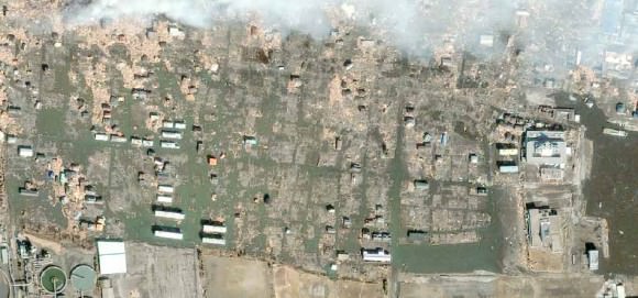
Sendai, Japan after the disaster. Satellite image courtesy of GeoEye.

[/caption]

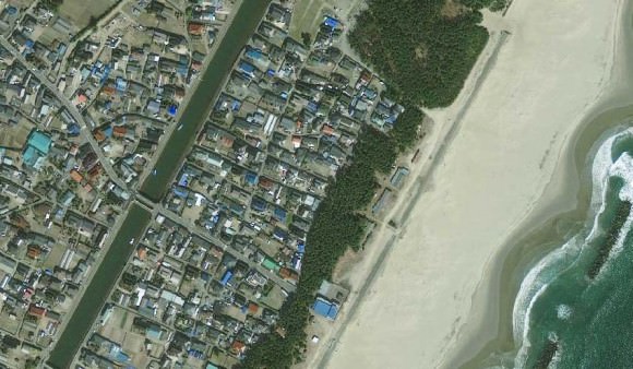
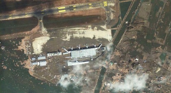
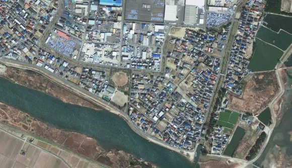
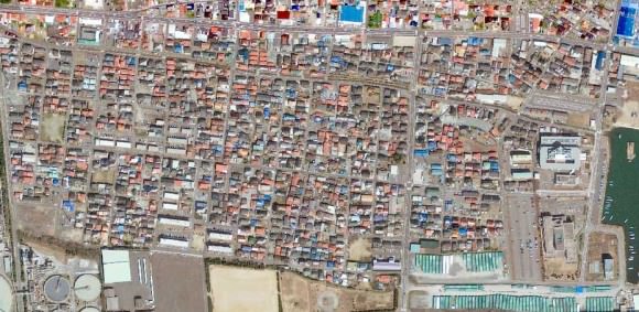
Photos from the GeoEye satellite imaging company from before and after the March 11 earthquake and tsunami in Japan show sobering views from above of the disaster. Above is the town of Sendai, Japan after the quake, below is how it looked before catastrophe struck.

Arahama, Japan before the disaster. Satellite image courtesy of GeoEye.

See more below.

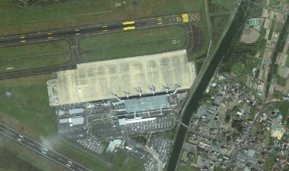
The Sendai Airport after the disaster. Satellite image courtesy of GeoEye.
The Sendai Airport in August of 2010. Satellite image courtesy of GeoEye.
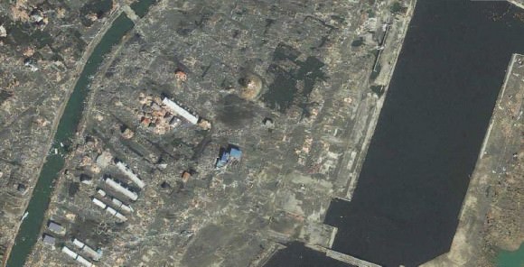
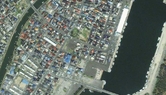
Yuriage, Japan on March 12, 2011. Satellite image courtesy of GeoEye.
Yuriage, Japan on April 4, 2010. Satellite image courtesy of GeoEye.
Sendai, Japan on March 12, 2011. Satellite image courtesy of GeoEye.
Sendai, Japan on April 4, 2010. Satellite image courtesy of GeoEye.
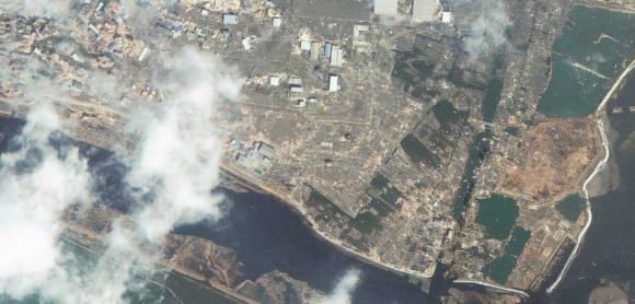
Ishinomaki, Japan on March 12, 2011. Satellite image courtesy of GeoEye.
Ishinomaki, Japan on April 4, 2010. Satellite image courtesy of GeoEye.

Below is an images from the MODIS Rapid Response System, which is producing twice-daily images of Japan in response to the disaster.

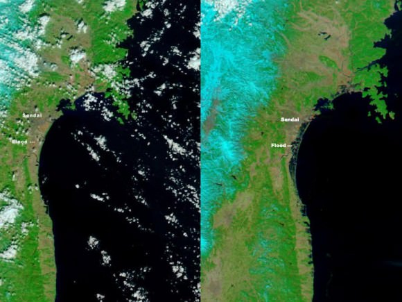
The Moderate Resolution Imaging Spectroradiometer (MODIS) on NASA’s Aqua satellite took the right image on Mar. 13, 2011, while the MODIS sensor on NASA’s Terra satellite took the left image on Feb 26, 2011. NASA images courtesy the MODIS Rapid Response Team at NASA GSFC.

These two images, from the MODIS instrument on NASA’s Aqua satellite from Mar. 13, 2011 on the right, and the the MODIS sensor on NASA’s Terra satellite from Feb. 26, 2011 on the left before the earthquake and tsunami. Both images were made with infrared and visible light to highlight the presence of water on the ground. Plant-covered land is bright green, bare earth is tan-pink, and snow is blue. The city of Sendai is brown.

At this level of detail, the flooding along the coastline is the most obvious sign of the destructive earthquake and tsunami that struck Japan on March 11. A bright orange-red spot near the city of Sendai is the thermal signature from a fire, also likely caused by the earthquake. The photo-like true-color version of the image shows a plume of black smoke extending east over the ocean.

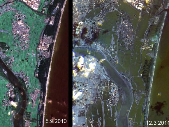
The German Aerospace Center (Deutsches Zentrum fur Luft- und Raumfahrt; DLR) is responding through its Center for Satellite Based Crisis Information (Zentrum fur Satellitengestutzte Kriseninformation; ZKI), based at its site in Oberpfaffenhofen, and provided the image below.

Japan's Coastline Before and After the Tsunami These images show the effects of the tsunami on Japan's coastline. The image on the left was taken on Sept. 5, 2010; the image on the right was taken on March 12, 2011, one day after an earthquake and resulting tsunami struck the island nation. Image Credit: German Aerospace Center (DLR)/Rapid Eye

Sources: GeoEye, New York Times, NASA, Space Daily