[/caption]
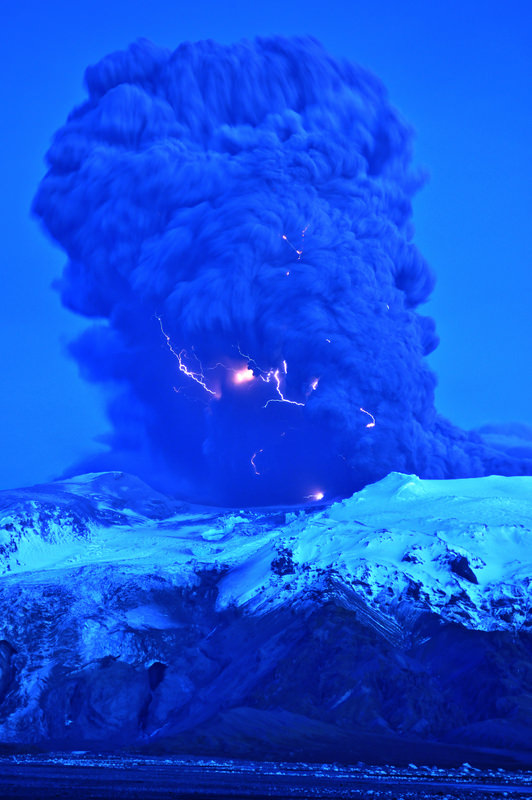
Astronomer Snaevarr Gudmundsson from Iceland was able to travel to within just a few kilometers from the Eyjafjallajokull volcano, and shared his incredible close-up images with Universe Today. “I stayed near the volcano from about 16:00 hours to 22:00 hours on Saturday and watched its impressive eruption,” Gudmundsson said in an email to me. “Amazing event, awesome explosions of 1200 °C hot magma reaching ice and water. I shot more than 550 images during these hours of continuous enjoyment. Sounds ridiculous but its ever changing appearance was never boring.”
The massive plume put on an impressive display – from lightning forming within the plume to an incredible amount of spewing ash. On one of following pictures you can see helicopter for size comparison of the plume
. Image courtesy of and copyright Snaevarr Gudmundsson.")
Gudmundsson said he and other photographers were a safe distance from the eruption, but were a few kilometers away. “Nearby was a small river and its prominent sound prevented us from hearing much in the eruption itself except a loud roar from thunders from time to time,” he said. “During daylight we even glimpsed some lightning but at dusk (the photo is taken at about 22:00 in the evening) they were easily spotted especially during active periods of explosions.”

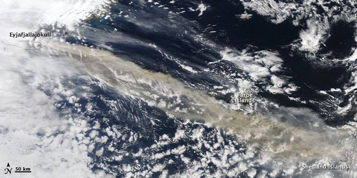
I asked if there was any smell associated with the Iceland volcano and Gudmundsson said there was a bit of sulphuric smell in the air even though they were in a location where the wind was blowing towards the volcano. “The ash went to the other side of the volcano, as you can suggest, making life miserable for farmers and households below, but the rest of it climbed to higher altitude and from there to Europe.”
“From the foot of the volcano to the prominent top, seen in front of the tephra cloud (seen on some of the photos) the overall height is about 1300 -1400 m,” Gudmundsson said. “When the eruption began a huge flood went down beneath the obvious glacier to the left from the crater. And if you look closely on the photo showing the foot hills under the mountain a lot of icebergs can be seen on the flood plain. Under that same glacier was a rather deep lagoon (can’t been seen but sat between the two high moraines on either side of it, in front of the glacier) but sediment from the eruption filled it up in only two days at most! That is unbelievable. I have climbed this glacier many times but to approach it one usually must traverse the moraine, around the lagoon to reach the ice. But suddenly it is gone.”

Gudmundsson said the flood paths can be seen below the glacier as a narrow gorges carved into rather soft volcanic sediment.
Some of the latest reports from Iceland say that in some areas the volcanic fallout has been significant, clogging car engines, turning grass grey and reducing visibility to just a few meters.
The police say driving conditions can be very difficult in these places, but the area affected is remote with only a few hundred people, most of them living in isolated homes and many of them farmers. They have been advised to stay inside with the windows and doors shut and if they do venture out to wear goggles and a mask.
The staff of Landhelgisgæslan (Icelandic Coastal Patrol) captured this radar image of the craters in Eyjafjallajökull on Friday. There are three main openings and each one is 200-500m in diameter.

Our very special thanks to Snaevarr Gudmundsson for sharing his images and experiences of seeing the volcano “up close and personal.” Also thanks to Col Maybury of radio station 2NUR in Newcastle, Australia for connecting me with Snaevarr (yes my connection to Iceland came through Australia!) and also thanks to erlinger on Twitter for help with Icelandic translations of news reports.
Here are some more Iceland pictures.


")