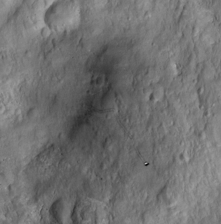
Curiosity’s Rambling Tracks Visible from Mars Orbit
Tracks from the Curiosity rover were imaged by the HiRISE camera on the Mars Reconnaissance Orbiter on January 2, 2012. Credit: NASA/JPL/University of Arizona.
Look closely and see where the Curiosity rover has been roving about inside Gale Crater on Mars, from “Bradbury Landing” to its current location in “Yellowknife Bay.” This shot was taken by the HiRISE camera on board the Mars Reconnaissance Orbiter on January 2, 2013.
“This image shows the entire distance traveled from the landing site (dark smudge at left) to its location as of 2 January 2013 (the rover is bright feature at right),” wrote HiRISE principal investigator Alfred McEwen on the HiRISE website. “The tracks are not seen where the rover has recently driven over the lighter-toned surface, which may be more indurated [hardened] than the darker soil.”
You can compare this image to one taken on September 8, 2012 to see how much the rover has driven in Gale Crater:
And here’s a map of Curiosity’s travels that NASA released yesterday:
Mission scientists said at a briefing yesterday (January 15, 2013) that between Sol (Martian day) 120 and Sol 121 of the mission — which equates to Dec. 7 and Dec. 8, 2012 — Curiosity crossed over a terrain boundary into lighter-toned rocks that correspond to high thermal inertia values observed by NASA’s Mars Odyssey orbiter. The green dashed line marks the boundary between the terrain types.
The inset graphs the range in ground temperature recorded each day by the Rover Environmental Monitoring Station (REMS) on Curiosity. Note that the arrival onto the lighter-toned terrain corresponds with an abrupt shift in the range of daily ground temperatures to a consistently smaller spread in values. This independently signals the same transition seen from orbit, and marks the arrival at well-exposed, stratified bedrock.
Sol 124 (Dec. 11, 2012) marked the arrival into an area called “Yellowknife Bay,” where sulfate-filled veins and concretions were discovered, along with much finer-grained sediments providing evidence of past water interacting with the surface.
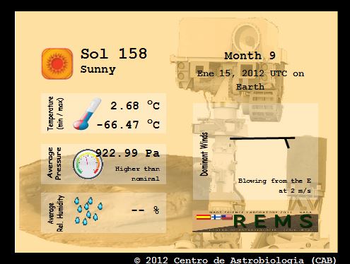
Here’s the Mars weather report provided by REMS for Sol 158 (January 15, 2013):
A video showing the new HiRISE image of Curiosity’s tracks:
Recent Posts
Next Generation Ion Engines Will Be Extremely Powerful
During the Space Race, scientists in both the United States and the Soviet Union investigated…
Neutron Stars Could be Capturing Primordial Black Holes
The Milky Way has a missing pulsar problem in its core. Astronomers have tried to…

Japan’s Lunar Lander Survives its Third Lunar Night
Space travel and exploration was never going to be easy. Failures are sadly all too…
Black Holes Can Halt Star Formation in Massive Galaxies
It’s difficult to actually visualise a universe that is changing. Things tend to happen at…
Mapping the Milky Way’s Magnetic Field in 3D
We are all very familiar with the concept of the Earth’s magnetic field. It turns…
NASA’s New Solar Sail Has Launched and Deployed
Solar Sails are an enigmatic and majestic way to travel across the gulf of space.…