The Black Marble: Stunning New Orbital Views of Earth at Night
This image of Asia and Australia at night is a composite assembled from data acquired by the Suomi NPP satellite in April and October 2012. Credit: NASA, NOAA, and the Department of Defense.
Two months of night-time imagery gathered by the Suomi NPP satellite have resulted in a stunning new look at Earth at night, appropriately nicknamed the Black Marble.
The nighttime views were made possible by the new satellite’s “day-night band” of the Visible Infrared Imaging Radiometer Suite. VIIRS detects light in a range of wavelengths from green to near-infrared and uses filtering techniques to observe dim signals such as city lights, gas flares, auroras, wildfires, and reflected moonlight. In this case, auroras, fires, and other stray light have been removed to emphasize the city lights.
“This is not your father’s low light sensor!” said Steve Miller, senior research scientist and deputy director of the Cooperative Institute for Research in the Atmosphere (CIRA), Colorado State University, speaking at the American Geophysical Union conference this week.
See more views and a video presentation of the VIIRS data below:
The new satellite is providing a much higher resolution across a greater band of light than previous night-light gathering satellites.
Originally developed for meteorologists to be able to look at nighttime clouds, the VIIRS data is providing a wide variety of information. “We are getting as much mileage from these data sets as we can,” said Chris Elvidge, who leads the Earth Observation Group at NOAA’s National Geophysical Data Center.
Elvidge and Miller said the data is being used to model population distribution, fossil fuel and CO2 emissions, and other information that can be gleaned from nighttime lights such finding power outages, determining astronomical viewing conditions, providing site selection for astronomical observatories, and looking at impacts of artificial lights on humans and animals.
The difference between electrical lights and fires, and night glow and auroras can even be determined by VIIRS.
North and South America at night is a composite assembled from data acquired by the Suomi NPP satellite in April and October 2012. Credit: NASA, NOAA, and the Department of Defense.
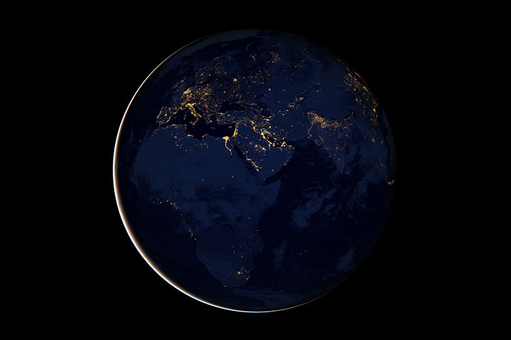
Europe, Africa, and the Middle East at night is a composite assembled from data acquired by the Suomi NPP satellite in April and October 2012. Credit: NASA, NOAA, and the Department of Defense.
Named for satellite meteorology pioneer Verner Suomi, NPP flies over any given point on Earth’s surface twice each day at roughly 1:30 a.m. and p.m. The polar-orbiting satellite flies 824 kilometers (512 miles) above the surface, sending its data once per orbit to a ground station in Svalbard, Norway, and continuously to local direct broadcast users distributed around the world,
.
Recent Posts
Astronomers Will Get Gravitational Wave Alerts Within 30 Seconds
Any event in the cosmos generates gravitational waves, the bigger the event, the more disturbance.…
Next Generation Ion Engines Will Be Extremely Powerful
During the Space Race, scientists in both the United States and the Soviet Union investigated…

Neutron Stars Could be Capturing Primordial Black Holes
The Milky Way has a missing pulsar problem in its core. Astronomers have tried to…
Japan’s Lunar Lander Survives its Third Lunar Night
Space travel and exploration was never going to be easy. Failures are sadly all too…
Black Holes Can Halt Star Formation in Massive Galaxies
It’s difficult to actually visualise a universe that is changing. Things tend to happen at…
Mapping the Milky Way’s Magnetic Field in 3D
We are all very familiar with the concept of the Earth’s magnetic field. It turns…