Video caption: This animation of LORRI (Long Range Reconnaissance Imager) images begins with a low-altitude look at the informally named Norgay Montes, flies northward over the boundary between informally named Sputnik Planum and Cthulhu Regio, turns, and drifts slowly east above Pluto's heart shaped Tombaugh Regio feature. It then rises about 10 times higher in altitude as NASA's New Horizons flew closest to Pluto on July 14, 2015. Credit: NASA/JHUAPL/SwRI/Stuart Robbins. See additional high resolution global Pluto and Tombaugh Regio mosaics below
Imagine yourself as a once in a lifetime
Plutonian tourist
sailing along in a spartan spaceship and looking out the windows to breathtaking alien landscapes with cameras snapping away.
Now for the first time in human history, you can embark on a heretofore unimaginable
flyover tour over Pluto
- the
most distant planetary system
yet explored by an emissary from Earth, thanks to the team propelling NASA's New Horizons spacecraft to the far flung reaches of our Solar System.
Just click on the video above and take the astounding aerial flyover tour above
Pluto's huge heart
and
the icy worlds
wondrous array of tectonically active flow plains and majestic mountain ranges towering kilometers skyward to its thin hazy atmosphere.
The animation is a gift to humanity as seen from the perspective of the
New Horizons probe as it flew past Pluto
on July 14, 2015 at a distance of 50,000 miles (80,000 kilometers).
The new flyover video beautifully melds "art and science" - and is the brainchild of Stuart Robbins, a New Horizons research scientist at the Southwest Research Institute in Boulder, Colorado.
"I have used the latest images to produce an animation that shows what it might be like to take an aerial tour through Pluto's thin atmosphere and soar above the surface that New Horizons explored," Robbins explained in a blog posting.
The flyover animation is based on a stitched together mosaic of New Horizons images that were then rendered onto a sphere of Pluto. The animation and spherical mosaic were created by New Horizons team members using the initial batch of images taken by the LORRI (Long Range Reconnaissance Imager) camera and downloaded from the spacecraft as of Sept. 11, 2015.
"The mosaic …. provides an incredibly accurate portrayal of Pluto's surface. It showcases …. the huge variety of terrain types that we see on Pluto."
The flyover begins low over the heart shaped region of Pluto informally named Tombaugh Regio by the New Horizons team. The LORRI images at the starting point over the
Norgay Montes mountain range
have a resolution up to 400 meters per pixel at a altitude of only about 120 miles (200 kilometers). The resolution then changes to about 800 meters per pixel.
The animation concludes with images of approximately 2.1 kilometers per pixel as the apparent altitude increases tenfold to about 1,500 miles (2,500 kilometers) as viewers perspective changes from an up close view to one revealing Pluto's disk rapidly growing to show about 80% of the hemisphere New Horizons flew closest to on July 14, 2015.
Here is Robbins explanation of the Plutonian terrain visible during your tourists eye view:
"Our tour starts low over the informally named Norgay Montes at a height of about 120 miles (200 kilometers). These jagged mountains rise almost 2 miles (3 kilometers) from the surrounding surface."
"We head north over Sputnik Planum (bright area to the left) and Cthulhu Regio (dark area to the right). While Sputnik Planum is smooth at this pixel scale, it's in marked contrast to Cthulhu Regio which has many large impact craters that indicate the Regio is much older. The differences in brightness are some of the largest natural brightness variations of any object in the solar system."
"Our view steadily rises to a height of about 150 miles (240 kilometers) and turns to look east. From this point, we drift slowly to the east, with Pluto's north pole to the left, Tombaugh Regio filling much of the middle of the view, and older, more cratered areas standing out in marked contrast to the younger glaciers of the "heart's" left lobe, Sputnik Planum."
"As we continue to fly, our flight path rises to more than 1,500 miles (2,500 kilometers) with the final view of most of the disk that New Horizons saw on July 14."
Robbins role on the New Horizons science team is using the images "to map craters across the surfaces of Pluto and its largest moon, Charon, to understand the population of impactors from the Kuiper Belt striking Pluto and Charon."
To see and study the whole disk of Pluto and the highest resolution view of the "heart" check out our global Pluto and Tombaugh Regio mosaics generated from raw images captured by New Horizons' Long Range Reconnaissance Imager (LORRI) and stitched together by the image processing team of Marco Di Lorenzo and Ken Kremer.
New Horizon's unveiled Pluto as a surprisingly vibrant and geologically active "icy world of wonders" as it barreled past the Pluto-Charon double planet system on July 14 at over 31,000 mph (49,600 kph) and collected unprecedented high resolution imagery and spectral measurements of the utterly alien worlds.
What are Pluto's newly discovered plains and mountains composed of?
"The plains are made of nitrogen. But nitrogen is too soft a material to build mountains out of, even in Pluto's weak gravity," says New Horizons Principal Investigator Alan Stern of the Southwest Research Institute, Boulder, Colorado.
"So the mountains must be made of something else stronger. Rock and water ice are the two most likely possibilities. But they are most likely water ice."
Here's our colorized and annotated version of the recently released backlit view of Pluto taken 15 minutes after closest approach as New Horizons spacecraft looked back toward the sun and captured a near-sunset view of the rugged, icy mountains and flat ice plains extending to Pluto's horizon.
[caption id="attachment_122485" align="aligncenter" width="2560"]
Just 15 minutes after its closest approach to Pluto on July 14, 2015, NASA's New Horizons spacecraft looked back toward the sun and captured this near-sunset view of the rugged, icy mountains and flat ice plains extending to Pluto's horizon - shown in this colorized rendition. The smooth expanse of the informally named icy plain Sputnik Planum (right) is flanked to the west (left) by rugged mountains up to 11,000 feet (3,500 meters) high, including the informally named Norgay Montes in the foreground and Hillary Montes on the skyline. To the right, east of Sputnik, rougher terrain is cut by apparent glaciers. The backlighting highlights more than a dozen layers of haze in Pluto's tenuous but distended atmosphere. The image was taken from a distance of 11,000 miles (18,000 kilometers) to Pluto; the scene is 780 miles (1,250 kilometers) wide. Credit: NASA/Johns Hopkins University Applied Physics Laboratory/Southwest Research Institute. Colorized/Annotated: Marco Di Lorenzo/Ken Kremer/kenkremer.com
[/caption]
Since the flyby, the team has been busy analyzing the science data returned thus far and "making some discoveries" says Stern.
"Pluto is showing us a diversity of landforms and complexity of processes that rival anything we've seen in the solar system."
"If an artist had painted this Pluto before our flyby, I probably would have called it over the top — but that's what is actually there."
New Horizons gathered about 50 gigabits of data as it hurtled past Pluto, its
largest moon Charon
and four smaller moons.
New Horizons also discovered that Pluto is the biggest object in the outer solar system and thus the 'King of the Kuiper Belt'.
The Kuiper Belt comprises the third and outermost region of worlds in our solar system.
Only about 5 to 6 percent has been downlinked to Earth so far. Stern says it will take about a year for all the data to get back.
So expect a year of endless treats and surprises from the 'King of the Kuiper Belt'!
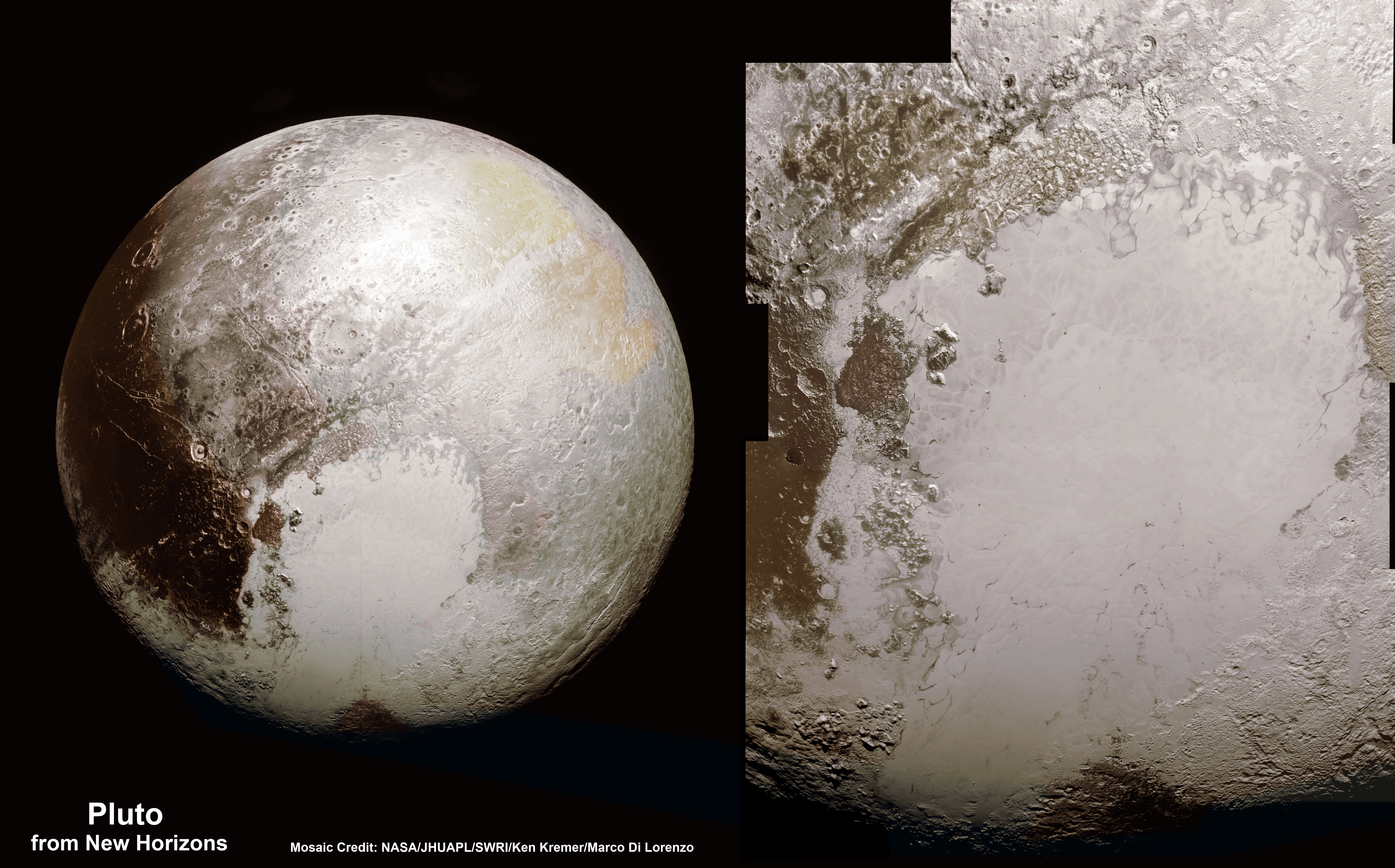
[caption id="attachment_122351" align="aligncenter" width="2077"]
This new global mosaic view of Pluto was created from the latest high-resolution images to be downlinked from NASA's New Horizons spacecraft and released on Sept. 11, 2015. The images were taken as New Horizons flew past Pluto on July 14, 2015, from a distance of 50,000 miles (80,000 kilometers). This new mosaic was stitched from over two dozen raw images captured by the LORRI imager and colorized. Credits: NASA/Johns Hopkins University Applied Physics Laboratory/Southwest Research Institute/Marco Di Lorenzo/Ken Kremer/kenkremer.com
[/caption]
Watch for Ken's continuing coverage of the Pluto flyby. He was onsite reporting live on the flyby and media briefings for Universe Today from the Johns Hopkins University Applied Physics Laboratory (APL), in Laurel, Md.
Stay tuned here for
Ken's
continuing Earth and planetary science and human spaceflight news.
Ken Kremer