New Map Shows ‘Marsquakes’ Shook Wet Valles Marineris Sand, NASA Says
A color mosaic of Candor Chasma (part of Mars' Valles Marineris) based on data from Voyager 1 and Voyager 2. Credit: NASA
Mars today is a planet that appears to be mostly shaped by wind, but that wasn’t always the case. A new map adds information to the hypothesis that “marsquakes” affected at least a part of the planet’s vast canyon, Valles Marineris, while the area contained spring-filled lakes.
When the damp sand got shaken up, it deposited itself in hills. NASA says the new map, based on observations from the Mars Reconnaissance Orbiter (which you can see below), adds credence to the theory that it was water that made these deposits.
“The conditions under which sedimentary deposits in it formed have been an open issue for decades,” NASA wrote in a press release. “Possibilities proposed have included accumulation in lakebeds, volcanic eruptions under glaciers within the canyons, and accumulation of wind-blown sand and dust.”
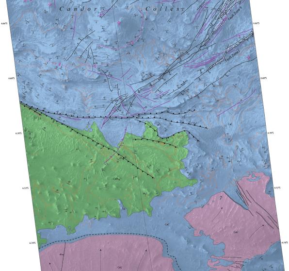
The map you see below was created by the U.S. Geological Survey, which has more extensive information on the findings at this website. The observations also produced a suite of research in recent years, such as this 2009 paper led by Scott Murchie at the Johns Hopkins University Applied Research Laboratory.
Recent Posts
Starlink on Mars? NASA Is Paying SpaceX to Look Into the Idea
NASA has given the go-ahead for SpaceX to work out a plan to adapt its…
Did You Hear Webb Found Life on an Exoplanet? Not so Fast…
The JWST is astronomers' best tool for probing exoplanet atmospheres. Its capable instruments can dissect…

Vera Rubin’s Primary Mirror Gets its First Reflective Coating
First light for the Vera Rubin Observatory (VRO) is quickly approaching and the telescope is…
Two Stars in a Binary System are Very Different. It's Because There Used to be Three
A beautiful nebula in the southern hemisphere with a binary star at it's center seems…
The Highest Observatory in the World Comes Online
The history of astronomy and observatories is full of stories about astronomers going higher and…
Is the JWST Now an Interplanetary Meteorologist?
The JWST keeps one-upping itself. In the telescope's latest act of outdoing itself, it examined…