New Map Shows ‘Marsquakes’ Shook Wet Valles Marineris Sand, NASA Says
A color mosaic of Candor Chasma (part of Mars' Valles Marineris) based on data from Voyager 1 and Voyager 2. Credit: NASA
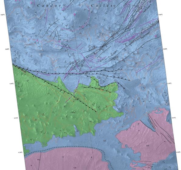
Mars today is a planet that appears to be mostly shaped by wind, but that wasn’t always the case. A new map adds information to the hypothesis that “marsquakes” affected at least a part of the planet’s vast canyon, Valles Marineris, while the area contained spring-filled lakes.
When the damp sand got shaken up, it deposited itself in hills. NASA says the new map, based on observations from the Mars Reconnaissance Orbiter (which you can see below), adds credence to the theory that it was water that made these deposits.
“The conditions under which sedimentary deposits in it formed have been an open issue for decades,” NASA wrote in a press release. “Possibilities proposed have included accumulation in lakebeds, volcanic eruptions under glaciers within the canyons, and accumulation of wind-blown sand and dust.”
The map you see below was created by the U.S. Geological Survey, which has more extensive information on the findings at this website. The observations also produced a suite of research in recent years, such as this 2009 paper led by Scott Murchie at the Johns Hopkins University Applied Research Laboratory.
Recent Posts
Fish Could Turn Regolith into Fertile Soil on Mars
What a wonderful arguably simple solution. Here’s the problem, we travel to Mars but how…
New Simulation Explains how Supermassive Black Holes Grew so Quickly
One of the main scientific objectives of next-generation observatories (like the James Webb Space Telescope)…

Don't Get Your Hopes Up for Finding Liquid Water on Mars
In the coming decades, NASA and China intend to send the first crewed missions to…
Webb is an Amazing Supernova Hunter
The James Webb Space Telescope (JWST) has just increased the number of known distant supernovae…
Echoes of Flares from the Milky Way’s Supermassive Black Hole
The supermassive black hole at the heart of our Milky Way Galaxy is a quiet…
Warp Drives Could Generate Gravitational Waves
Will future humans use warp drives to explore the cosmos? We're in no position to…