Astronaut Photos Create a Map of the World
A map of the world made up of the locations of ISS astronaut photos (Nathan Bergey/open.nasa.gov)
If you could spend a few months — or even a few days — living aboard the ISS, what would you take pictures of? Earth, most likely, with your favorite landforms and your family’s and friends’ hometowns ranking high on the list. After a while, I’m sure plenty of other Earthly features would become photo targets — weather, aurorae, world cities at night, etc. — but ultimately, over the course of your stay in orbit, you would be able to see a trend in the pictures you take, and where you took them.
And over the span of 35 missions across more than 12 years, the graph above shows the trend of all the astronauts’ pictures. Look familiar?
Created by open-source NASA data aficionado Nate Bergey, the image above is a map made up of over a million points (1,129,177, to be exact) each representing the global coordinates of an JSC-archived photograph taken from the ISS.
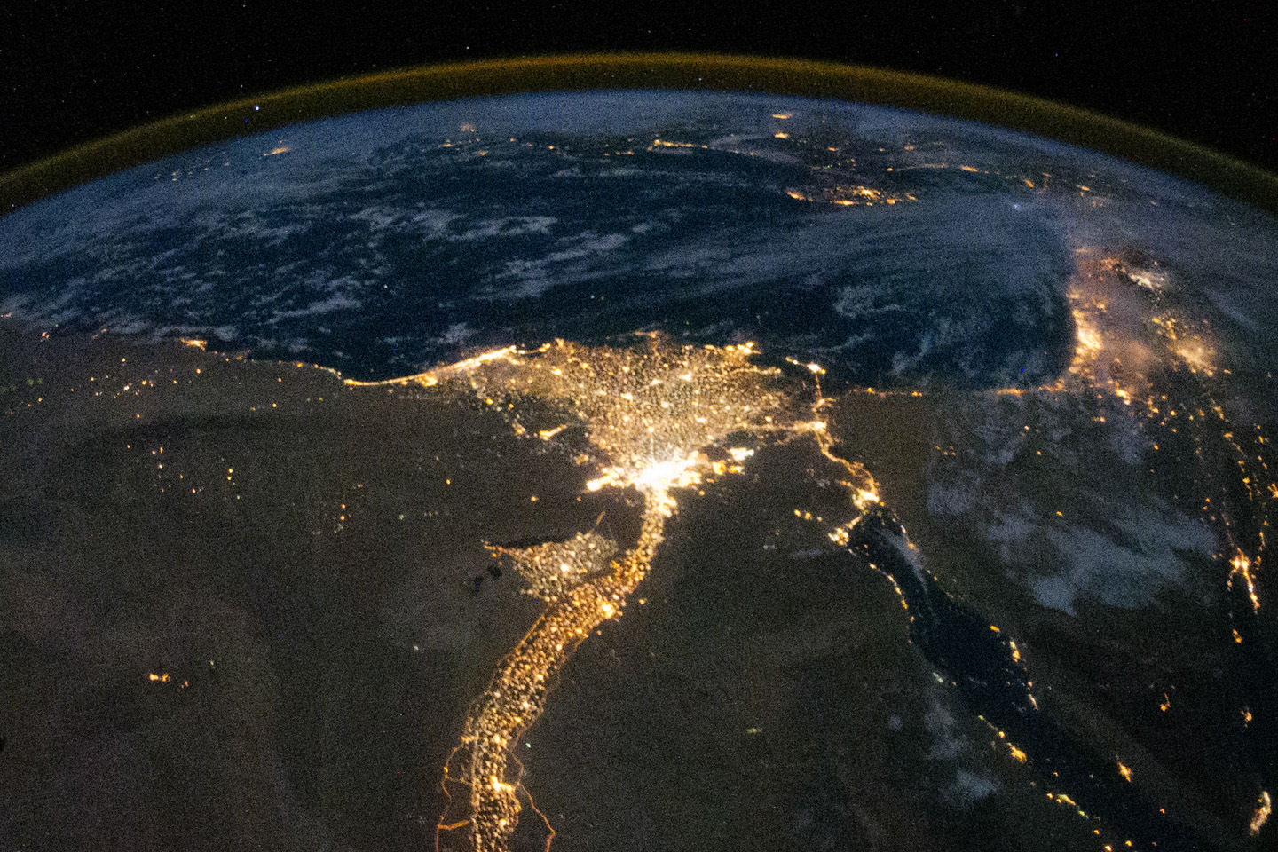
Clearly the continents are astronauts’ favored photo subjects, with the populous urban areas of North America, Europe, Egypt and the Middle East, as well as the western and southern coasts of South America standing out.
“This makes sense, photos of clouds over an otherwise blank ocean get old after a while,” Nate Bergey wrote on his blog, open.nasa.gov. “I’m sure every astronaut has taken at least one photograph of the town they grew up in.”
Of course, the map doesn’t create an image of the entire globe. This is because the points denote actual over-ground coordinates of the Station (not necessarily what the photos themselves are of) and “the ISS stays between about 50° and -50° latitude as it orbits the Earth,” as noted by Bergey.
A map of the world with the points overlaid onto it, color-coded by mission, shows the difference:
Bergey also notes the proliferation of purple-colored dots… these indicate the hundreds of images taken by NASA astronaut Don Pettit during Expedition 30/31, when he created incredible time-lapse videos of the Earth from the ISS.
With such a unique and lofty perspective of our world, it’s no wonder that astronauts spend so much time snapping photos — I can’t say I’d be able to tear myself away from the window myself! Read more about Nate Bergey’s project and how he created his map on his open.NASA blog here.
Recent Posts
Astronomers Will Get Gravitational Wave Alerts Within 30 Seconds
Any event in the cosmos generates gravitational waves, the bigger the event, the more disturbance.…
Next Generation Ion Engines Will Be Extremely Powerful
During the Space Race, scientists in both the United States and the Soviet Union investigated…

Neutron Stars Could be Capturing Primordial Black Holes
The Milky Way has a missing pulsar problem in its core. Astronomers have tried to…
Japan’s Lunar Lander Survives its Third Lunar Night
Space travel and exploration was never going to be easy. Failures are sadly all too…
Black Holes Can Halt Star Formation in Massive Galaxies
It’s difficult to actually visualise a universe that is changing. Things tend to happen at…
Mapping the Milky Way’s Magnetic Field in 3D
We are all very familiar with the concept of the Earth’s magnetic field. It turns…