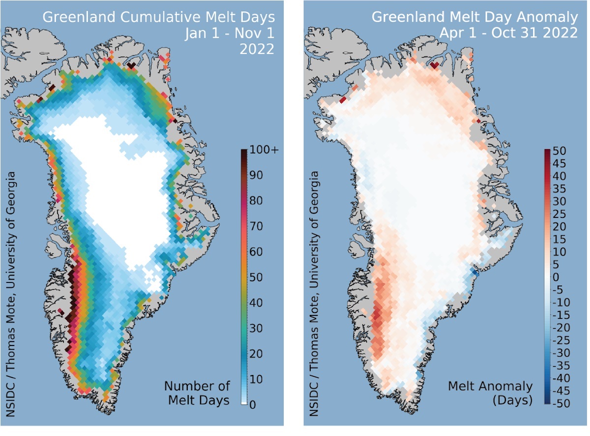
Satellite Photo

If you're looking for a satellite photo, this is probably one of the best times in recent history. There are thousands of satellites orbiting the Earth, taking photos of the ground, and many of these images are available through the internet for free.
If you're looking for a satellite photo of a specific spot on Earth, I'd suggest starting with Google Maps. This is a web-based tool from Google that shows you a satellite image of the whole Earth. You can drag the map around, and zoom in and out with your mouse scroll wheel. You can also type in a specific street address, and Google Maps will center the satellite image right over that location. In many cities the satellite photos are capture at 41 cm resolution, so you can easily see your house, car out front and even more.
Another great tool from Google is Google Earth. You install the Google Earth application to your computer; they have versions for PCs, Macs, and Linux machines. When you run the program, you see a 3-dimensional view of the Earth. You can spin it, zoom around, in and out. You can see different overlays, street views, satellite views, and even contour maps. Google Earth also has really good printing function, so once you've found the satellite photo you want, you can print a copy off pretty easily.
Those are great tools from Google if you want to see a specific spot on Earth. But if you just want to see some of the best satellite photos ever taken, for example of famous landmarks or geographical features, there are several other resources. Check out NASA's Earth Observatory. They highlight a different image every day, and have a huge catalog of other images. There are some other cool tools from NASA, like NASA Earth From Space, which are photos of Earth taken by astronauts. You should also check out NASA Visible Earth, which has some favorite images of the planet, like the famous "Blue Marble".
There are also the commercial satellite photo suppliers. For example, GeoEye supplies many of the photographs used by Google Earth and Google Maps. You can see some of the best images from their collection, and even order images to get as a poster.
We have written many articles about how satellite photos are used to help scientists understand the Earth. Here's an article about wildfires in California. And here's an article about bushfires in Australia.
We have also recorded an episode of Astronomy Cast all about Earth. Listen here, Episode 51: Earth.
Filed under: Astronomy | No Comments »


