The latest satellite in the Landsat family of Earth observation spacecraft has collected its "first light" images of our planet. Landsat 9 launched on September 27, 2021 and it continues the nearly 50-year tradition of making critical observations to help with energy and water management, forest monitoring, human and environmental health, urban planning, disaster recovery and agriculture.
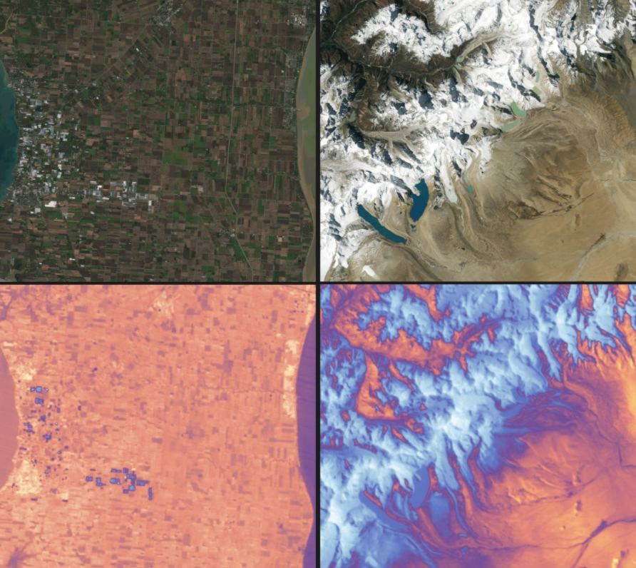
The first images were taken on October 31, and have now been posted online. Our lead image shows (left) rectangles of farm fields in southern Ontario, sandwiched between Lake Erie and Lake St. Clair, and (right) snow and glaciers in the Himalayan mountains, leading to the flat Tibetan Plateau. Both photos are shown in different wavelengths from two instruments. The Operational Land Imager 2 (OLI-2), detects visible, near-infrared and shortwave-infrared light in nine wavelengths, and the Thermal Infrared Sensor 2 (TIRS-2), detects thermal radiation in two wavelengths to measure Earth's surface temperatures and its changes.
"The incredible first pictures from the Landsat 9 satellite are a glimpse into the data that will help us make science-based decisions on key issues including water use, wildfire impacts, coral reef degradation, glacier and ice-shelf retreat and tropical deforestation," said?USGS Acting Director Dr. David Applegate.?"This?historic moment?is the culmination of?our?long?partnership with NASA on Landsat 9's development, launch and initial operations, which will better support environmental sustainability, climate change resiliency and economic growth – all while expanding an unparalleled record of Earth's changing landscapes."?

Landsat 9 reached its final orbital altitude of 438 miles (705 kilometers), in a near-polar, Sun-synchronous orbit.
Its predecessor, Landsat 8 – launched in 2013 -- is still hard and work. By combining the power of both Landsat 8 and 9, the two satellites can now photograph the entire Earth every eight days.
The two Landsats are very similar in design, but Landsat 9 features several improvements. NASA said the new satellite transmits data with higher radiometric resolution back down to Earth, allowing it to detect more subtle differences, especially over darker areas like water or dense forests. For example, Landsat 9 can differentiate more than 16,000 shades of a given wavelength color; Landsat 7, the satellite being replaced, detects only 256 shades. This increased sensitivity will allow Landsat users to see much more subtle changes than ever before.
"First light is a big milestone for Landsat users – it's the first chance to really see the kind of quality that Landsat 9 provides. And they look fantastic," said Jeff Masek NASA's Landsat 9 project scientist at Goddard Space Flight Center. "When we have Landsat 9 operating in coordination with Landsat 8, it's going to be this wealth of data, allowing us to monitor changes to our home planet every eight days."
All of the new Landsat imagery – as well as data from over the years --is available online here.