
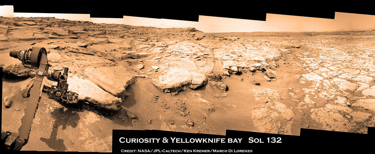
Image Caption: Photo mosaic shows NASA’s Curiosity Mars rover in action reaching out to investigate rocks at a location called Yellowknife Bay on Sol 132, Dec 19, 2012 in search of first drilling target. The view is reminiscent of a dried up shoreline. Curiosity’s navigation camera captured the scene surrounding the rover with the arm deployed and the APXS and MAHLI science instruments on tool turret collecting microscopic imaging and X-ray spectroscopic data. The mosaic is colorized. See the full 360 degree panoramic and black & white versions below. Credit: NASA/JPL-Caltech/Ken Kremer/Marco Di Lorenzo
Following the Christmas season break for panoramic imaging of her surroundings, NASA’s Curiosity robot has resumed roving around the shallow depression she reached before the holidays called ‘Yellowknife Bay’ and just arrived at a slithery rock called ‘Snake River’.
The top priority is to locate a target rock to drill into – and that momentous event could at last take place in the next week or so. The drill is the last of Curiosity’s suite of ten science instruments to be fully checked out and commissioned for use.
The drilling scene will look a lot like our photo mosaics, above and below, showing the robotic arm deployed for action. The drill is located on the tool turret at the end of the 7 foot (2.1 meter) long mechanical marvel.
The Curiosity research team is using the newly collected cache of high resolution color images to scan her surroundings in search of scientifically interesting rocks for the historic inaugural use of the high powered hammering drill.
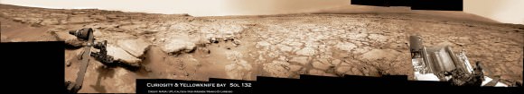
Image Caption: Photo mosaic shows NASA’s Curiosity Mars rover in action reaching out to investigate rocks at a location called Yellowknife Bay on Sol 132, Dec 19, 2012. In search of first drilling target the rover drove to a spot at the right edge of this mosaic called Snake River rock. Curiosity’s navigation camera captured the scene surrounding the rover with the arm deployed and the APXS and MAHLI science instruments on tool turret collecting imaging and X-ray spectroscopic data. Base of Mount Sharp visible at right.The mosaic is colorized with patches of sky added to fill in gaps. Click to enlarge. Credit: NASA/JPL-Caltech/Ken Kremer/Marco Di Lorenzo
The percussive drill will collect the first ever powdered samples from the interior of Martian rocks for analysis by a pair of state-of-the-art analytical chemistry instruments located inside the rover named SAM and CheMin.
“We are firing on all cylinders now and our last thing to do is drilling, and we really hope to start on that process beginning next week,” said John Grotzinger, the mission’s chief scientist of the California Institute of Technology, in an interview with Jonathan Amos of the BBC.
The rover is also using the APXS X-ray mineral spectrometer, ChemCam rock blasting laser and MAHLI hand lens imager to gather science characterization data helpful in choosing the drill target.
Today (Jan. 5) marks exactly 5 months since Curiosity’s hair-raisingly successfully touchdown on Aug. 5, 2012 on the gravelly plains of Gale Crater beside the towering foothills of Mount Sharp, a 3 mi (5 km) high layered mountain holding deposits of hydrated minerals. Mount Sharp is the main destination of Curiosity’s mission.
On Jan. 3 (Sol 147), Curiosity drove another 10 feet (3 meters) northwestward and pulled up to a sinuous rock feature called “Snake River” as part of a campaign to survey a variety of rocks from which to select the drilling site.
“It’s one piece of the puzzle,” says John Grotzinger. “It has a crosscutting relationship to the surrounding rock and appears to have formed after the deposition of the layer that it transects.”
‘Snake River’ sinuous Rock Feature Viewed by Curiosity Mars Rover on Sol 133. On Sol 147 (Jan 3. 2013), the rover drove to within arm’s reach of Snake river for up close examination as possible drill target. Credit: NASA/JPL-Caltech
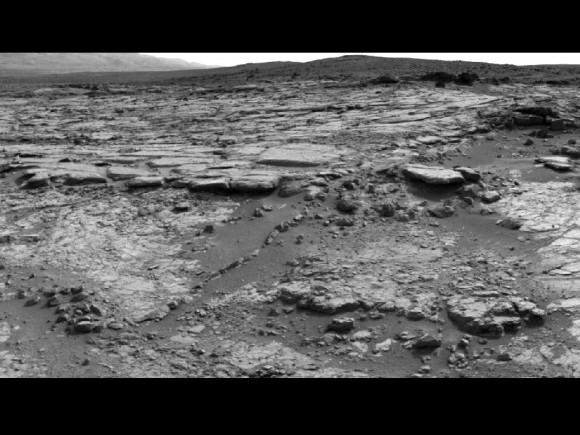
Snake River is a thin curving line of darker rock cutting through flatter rocks and jutting above sand, says NASA. It’s located at the right side edge of our Sol 132 photo mosaic stitched together from raw images by the image processing team of Ken Kremer & Marco Di Lorenzo to provide a context view of the scenery – and were also featured at NBC News by Alan Boyle, BBC News, NASA Watch and the NY Daily News.
So far the robot has driven a total of 2,303 feet (702 meters) and snapped nearly 36,000 pictures.
Yellowknife Bay is a basin inside an area dubbed ‘Glenelg’ that features a flatter and lighter-toned type of terrain from what the mission crossed during its first four months inside Gale Crater. The rover descended about 2 feet (0.5 m) down a slight incline to reach the inside of the depression in December 2012.
“We’re down at the very lowest layer – what would be the oldest layer that we would see in this succession that might be five to eight meters thick, and that is very likely where we are going to choose our first drilling target, because suddenly we’ve come into an area that represents a very high diversity of things we haven’t seen before,” said Grotzinger to the BBC.
“The place where Curiosity is right now is a small stack of layers – very impressive – and they could be 3-3.5 billion years old, and so we’re very excited about this because unlike the soil which we were analyzing before the holiday season – a loose, windswept patch of dirt on the surface of Mars – we’re now going to start digging down into the very ancient bedrock which we really built the rover to look at,” explained Grotzinger.
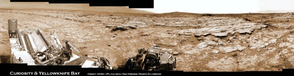
Image caption: Curiosity peaks around Yellowknife Bay on Sol 125, Dec 12, 2012. The rover has continued driving inside the basin in search of 1st rock drill target in Jan 2013. Credit: NASA/JPL-Caltech/Ken Kremer/Marco Di Lorenzo
The mission goal is to search for habitats and determine if Mars ever could have supported microbial life in the past or present during the 2 year primary mission phase.
“We use these layers as a sort of recording device of past events and conditions, and the rover has the same kind of analytical capability that we would use here on Earth to tell us about the early environmental conditions; and, if life had ever evolved, [whether it would] be the kind of environment that would have been conducive towards sustaining that life,” Grotzinger elaborated to the BBC.
Stay tuned.
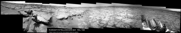
Image Caption: Photo mosaic shows NASA’s Curiosity Mars rover in action reaching out to investigate rocks at a location called Yellowknife Bay on Sol 132, Dec 19, 2012. Credit: NASA/JPL-Caltech/Ken Kremer/Marco Di Lorenzo
Yowza! If that is the basement of the crater sediments, and they suspect it is really that old, it could stretch into the sweet range when Mars could have been surface habitable.
If it is early crater infill, this can get more exciting than I thought!
If I understand what you are saying this implies that Mars might have had a thick enough an atmosphere and liquid water so that it could have developed a reasonable biological environment or ecosystem.
LC
…with its residues – extremophile (from an Earth point of view) micro-life still “hanging around” on Mars manifesting itself in things like seasonal Dark Dune Spots (DDS: http://www.lpi.usra.edu/meetings/lpsc2001/pdf/1543.pdf and http://www.lpi.usra.edu/meetings/lpsc2002/pdf/1108.pdf) grow which still is/was not subjected to detailed studies beyound theoretical speculations, methane plumes (also seasonal), rock varnish like rock coatings and positive results from life detection experiments of the 1970er Viking landers. 😉
The Viking bio-detection experiments were too ambiguous to conclude much. The fact that perchlorates are fairly common on Mars seems to suggest that maybe perchlorates decomposed the organic materials in the experiments. Put organic material in a small container of bleach. You will notice out gassing and that the container will actually warm up.
It is though intriguing that the ages here suggest a half to one billion years where life could have existed or have at least emerged. If so then I think life would have adapted to the colder, drier and low pressure conditions that Mars evolved into.
LC
But a chemical reaction due to perchlorates wont be stopped by heat sterilizing control samples as done/happened in the Viking LR and partly PR (C fixation) experiments.
If people would really understand the Viking biology experiments and its implications we would certainly be much closer to the resolution of life on Mars! I predict that even 10 more MSL class missions supervised by the NASA Mars geologists crowd wont bring us closer to the answer if not fitted with life science instrumentation including improved Viking style life detection experiments – also not to forget a better landing site selection.
By the way I do not claim the Viking experiment results were not ambitious but to say the least they were worth following up for sure!
No, I was noting the implications of that. If Mars was habitable then, Curiosity may already have access to a record of that.
It’s intriguing that Mars supposedly once had bodies of open water given that 3.5 billion years ago the sun was several % fainter than it is today. Combine this with the evidence that around 0.7 billion years ago Earth was a frozen ice ball with only a small equatorial area without ice for tens of millions of years. Lots to learn here.