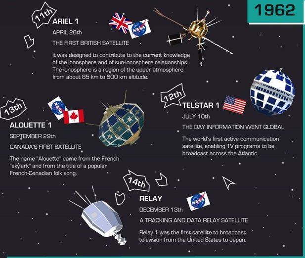
Excerpt from the infographic "An Early History of Satellites." Credit: Broadband Wherever.
It’s not often that one associates a satellite with French folk songs, but this infographic does that and more. Below you will find the major launches of the early space age — from the Soviet Union’s Sputnik to the Czechoslovakian Magion 1 — showing how satellites quickly evolved between 1957 and 1978.
In two decades, satellites changed from simple transmitters and receivers to sophisticated machines that carried television signals and science instruments.
Another striking thing about this Broadband Wherever graphic: the number of participating countries. While we often think of the early Space Age as being dominated by the United States and Soviet Union, you can see other nations quickly rushing their own satellites into orbit: Canada, Italy, Australia, India and more.
Enjoy the sound bites and cute graphics below. Full sources for the information are listed at the bottom of the infographic.
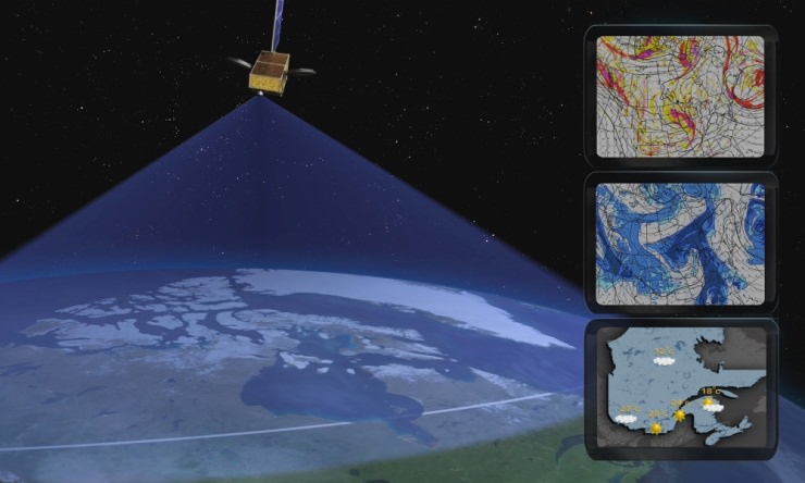
This image was captured by NOAA's GOES-East satellite on January 6, 2014 at 1601 UTC/11:01 a.m. EST. A frontal system that brought rain to the coast is draped from north to south along the U.S. East Coast. Behind the front lies the clearer skies bitter cold air associated with the Polar Vortex.
If you live in the north and eastern part of the US, you’re probably experiencing some frigid weather. You’re probably also hearing people talk about something called a “polar vortex.”
Just what is a polar vortex and why is it making the temperatures so cold?
This image was captured by NOAA’s GOES-East satellite on Jan. 6, 2014, at 11:01 a.m. EST (1601 UTC). A frontal system that brought rain and snow to the US East coast is seen draped from north to south, and behind the front lies the clearer skies bitter cold air associated with the polar vortex. Also visible in the image is snow on the ground in Minnesota, Wisconsin, Illinois, Indiana, Ohio, Michigan, Iowa and Missouri. The clouds over Texas are associated with a low pressure system centered over western Oklahoma that is part of the cold front connected to the movement of the polar vortex.
NASA explains that the polar vortex is a “whirling and persistent large area of low pressure, found typically over both North and South poles.”
Weather reports say the northern polar vortex was pushing southward over western Wisconsin and eastern Minnesota on Monday, Jan. 6, 2014, and was bringing frigid temperatures to half of the continental United States. It is expected to move northward back over Canada toward the end of the week.
More about the polar vortex:
Both the northern and southern polar vortexes are located in the middle and upper troposphere (lowest level of the atmosphere) and the stratosphere (next level up in the atmosphere). The polar vortex is a winter phenomenon. It develops and strengthens in its respective hemispheres’ winters as the sun sets over the polar region and temperatures cool. They weaken in the summer. In the Northern Hemisphere, they circulate in a counterclockwise direction, so the vortex sitting over western Wisconsin is sweeping in cold Arctic air around it.
Typical meteorological applications for the Polar Communications and Weather (PCW) mission. Credit: CSA.
OTTAWA, CANADA — A new Canadian satellite — should it launch — might carry a sort of magnetized force field on board to keep charged particles away from vital electronics.
The Polar Communications and Weather Satellite (PCW), depending on its orbit, could skim through the radiation-filled Van Allen belts on its mission to deliver reliable weather reports and communications to northern communities.
Its polar orbit will likely take it through clouds of charged particles high above Earth. If the particles hit crucial components on the spacecraft, it can short out electronics and cause brownouts or complete failure. This has happened several times before, such as to the Japanese ADEOS-II satellite after a large solar storm in 2003.
A concept being explored by Winnipeg’s Magellan Aerospace, one of the companies working on the early phase studies, would make a plasma field around PCW, a sort of “mini magnetosphere” that would use large dipole magnets to deflect charged particles.
It may also be useful for human missions in the future, said Paul Harrison, a satellite control systems engineer at Magellan Aerospace, although he acknowledged the technology is still in an early stage and that they would like a demonstrator mission to fly first.
“It’s still very much in the development phase. We want to develop for satellites before we start sticking people in them,” Harrison said in a presentation at the Canadian Space Society annual summit in Ottawa, Canada, today (Nov. 14.)
He also said it is not clear if the technology would be useful for cosmic rays that originate from outside the solar system, as well as charged particles that flow from the sun and are present near the Earth.
PCW has not been assigned a launch date yet and is still in the early stages of development. Other issues being explored include how to keep track of it without constant access to near-equator-orbiting GPS satellites, and how to maintain temperature control as it plunges from day to night to day again during its journey.
Its orbit could be a 12-hour Molniya orbit or perhaps a 16-hour or 24-hour highly eccentric orbit, depending on what designers feel is best.
CORRECTION: This article has been changed to say “near-equator-orbiting” GPS satellites.
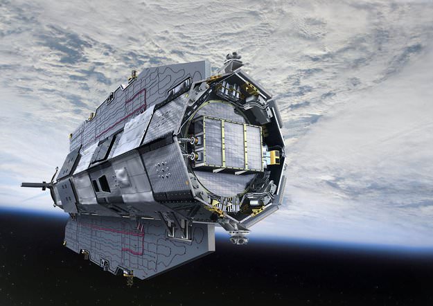
Artist rendition of the GOCE Satellite in orbit. Credit: ESA
ESA’s GOCE satellite has reentered Earth’s atmosphere, with most of the spacecraft disintegrating high in the atmosphere. There have been no reports of damage to property or sightings of debris. Astrophysicist and satellite watcher Jonathan McDowell reported that the spacecraft came down at approximately 00:16 UTC on November 11, 2013 over the South Atlantic Ocean east of Tierra del Fuego – an archipelago off the southernmost tip of the South America.
The last visible sighting of GOCE was at 22:42 UTC on Nov. 10 as it passed 121km (75 miles) above Antarctica, BBC reported.
While most of the 1100 kg satellite disintegrated in the atmosphere, an estimated 25% reached Earth’s surface, likely falling in the ocean.
“The one-ton GOCE satellite is only a small fraction of the 100–150 tons of man-made space objects that reenter Earth’s atmosphere annually,” said Heiner Klinkrad, Head of ESA’s Space Debris Office. “In the 56 years of spaceflight, some 15,000 tons of man-made space objects have reentered the atmosphere without causing a single human injury to date.”
The GOCE spacecraft was designed to fly low and has spent most of its mission roughly 500 km below most other Earth-observing missions, at an altitude of 255 km (158 miles), but has recently been at the lowest altitude of any research satellite at 224 km (139 miles).
Its durable construction and sleek design allowed it to stay in space for longer than expected; it nearly tripled its planned lifetime.
With GOCE data, scientists created the first global high-resolution map of the boundary between Earth’s crust and mantle – called the Moho – and to detect sound waves from the massive earthquake that hit Japan on 11 March 2011, among other results.
Read more about GOCE at ESA.
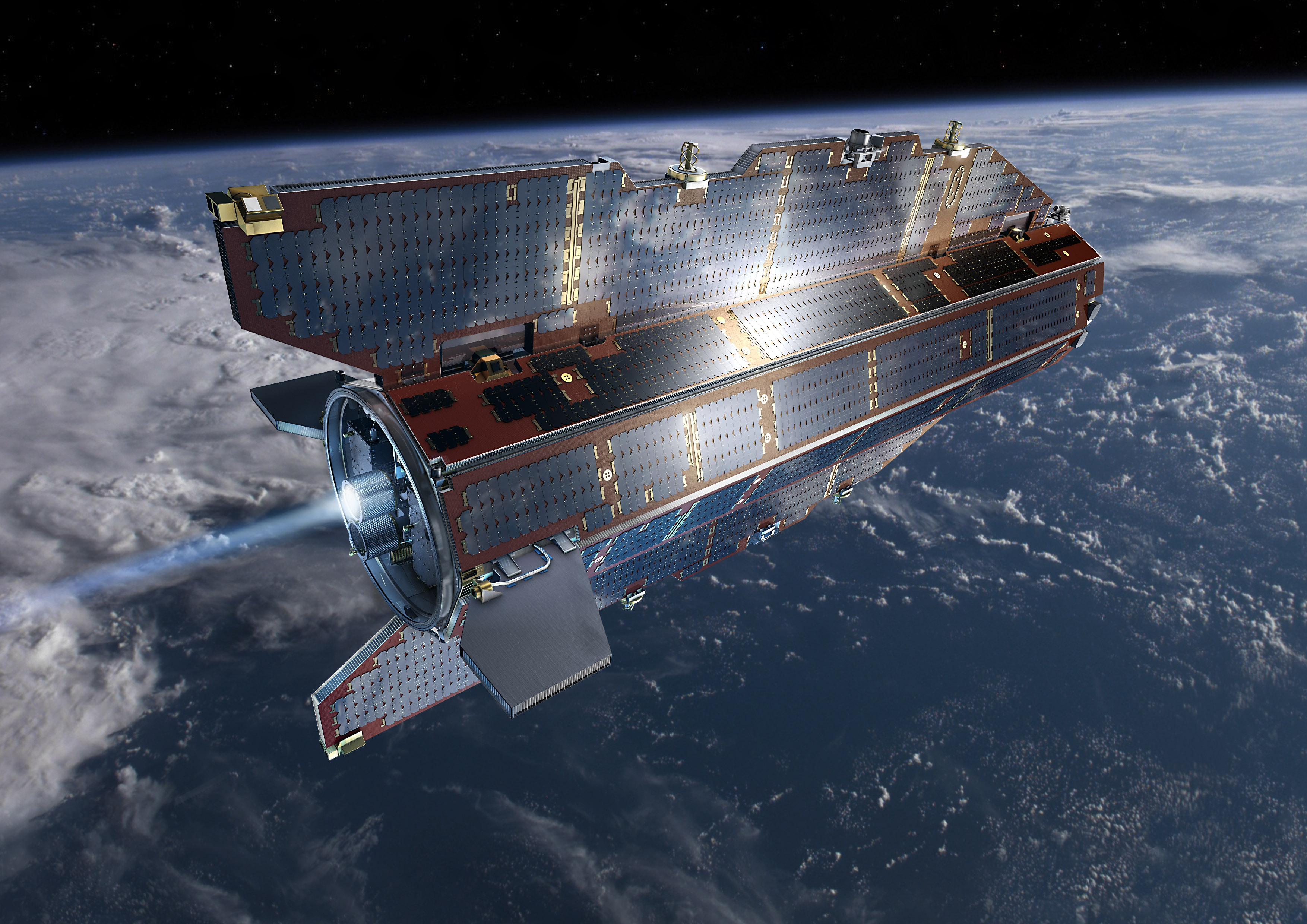
Artist rendition of the GOCE Satellite in orbit. Credit: ESA
The Gravity field and steady-state Ocean Circulation Explorer (GOCE) satellite has been orbiting Earth in super-low orbits since 2009, mapping out variations in Earth’s gravity in extreme detail. But its fuel ran out in mid-October and the satellite began its slow descent towards Earth, being brought lower and lower by the effects of the atmosphere. Engineers predict it will re-enter completely and fall back to Earth sometime this weekend.
But no one can say for sure when or where the 1-ton satellite will fall.
With no remaining fuel to guide its re-entry there’s no way to nudge or steer its descent. And while most of GOCE is predicted to disintegrate in the atmosphere, several parts might reach Earth’s surface. Experts predict as much as 25% of the spacecraft will survive reentry, as many parts are made of advanced materials, such as carbon-carbon composites.
Today, engineers from the GOCE mission said that the spacecraft is predicted to enter into Earth’s atmosphere sometime during the night between Sunday and Monday, November 10-11, 2013. Break-up of the spacecraft will occur at an altitude of approximately 80 km. “At the moment, the exact time and location of where the fragments will land cannot be foreseen,” says ESA.
The GOCE spacecraft was designed to fly low and has spent most of its mission roughly 500 km below most other Earth-observing missions, at an altitude of 255 km (158 miles), but has recently been at the lowest altitude of any research satellite at 224 km (139 miles).
Its durable construction and sleek design allowed it to stay in space for longer than expected; it nearly tripled its planned lifetime.
With GOCE data, scientists created the first global high-resolution map of the boundary between Earth’s crust and mantle – called the Moho – and to detect sound waves from the massive earthquake that hit Japan on 11 March 2011, among other results.
Heiner Klinkrad, Head of ESA’s Space Debris Office at ESOC, Darmstadt, Germany said that when the spacecraft reaches altitudes below 100 km, then atmospheric density will drastically increase on the spacecraft. It will enter at about 25,000 km/hour, and aerodynamic pressure and heating will cause a break-up of the spacecraft at approximately 80km altitude, causing a large number of fragments.
“The risk to the population on ground will be minute,” said Klinkrad. “Statistically speaking, it is 250,000 times more probable to win the jackpot in the German Lotto than to get hit by a GOCE fragment. In 56 years of space flight, no man-made space objects that have re-entered into Earth’s atmosphere have ever caused injury to humans.”
An international campaign will be monitoring the descent, involving the Inter-Agency Space Debris Coordination Committee. The situation is being continuously watched by ESA’s Space Debris Office, which will issue re-entry predictions and risk assessments.
ESA says they will keep the relevant safety authorities permanently updated.
The space age began on October 4, 1957 with the launch of the first artificial satellite, Sputnik 1. This tiny spacecraft lasted only three months in orbit, finally burning up in the Earth’s atmosphere.
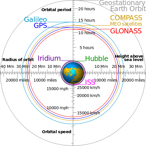
Following in these historic footsteps, many more spacecraft have been sent into Earth’s orbit, around the Moon, the Sun, the other planets, and even out of the Solar System itself. At the time that I’m recording this video, there are 1071 operational satellites in orbit around the Earth. 50 percent of which were launched by the United States.
Half of that 1071 are in Low-Earth Orbit, just a few hundred kilometers above the surface. Some of the most notable of these include the International Space Station, the Hubble Space Telescope, and many Earth observation satellites.
About a twentieth are in Medium-Earth Orbit, around 20,000 kilometers up, which are generally global positioning satellites used for navigation. A small handful are in elliptical orbits, where their orbit brings them closer and further to the Earth.
The rest are in geostationary orbit, at an altitude of almost 36,000 kilometers.
If we could see these satellites from Earth’s surface, they would appear to hang motionless in the sky. The fact that they remain over the geographic same area means they provide the perfect platform for telecommunications, broadcast or weather observations.
But there are many, many more artificial objects orbiting the Earth. In this collection of space debris we’re talking spent boosters, dead satellites, and even misplaced gloves. According to the United States Space Surveillance Network, there are more than 21,000 objects larger than 10 cm orbiting the Earth. Just a small fraction of these are operational satellites. It’s estimated there are a further 500,000 bits and pieces between 1 and 10 cm in size.
Near Earth orbit is so polluted with junk that the International Space Station is often moved to avoid impact with dangerous chunks of space debris. Many of these objects are created through collisions, and some scientists are worried that future space travel might be too risky if we get too much junk orbiting the planet. We might seal ourselves inside a shield of shrieking metal moving at 29,000 km/hour.
Looking outwards from our own orbit, at any time there are a handful of satellites orbiting the Moon. Right now, NASA’s Lunar Reconnaissance Orbiter and Lunar Atmosphere and Dust Environment Explorer are in lunar orbit. Further still, there’s 1 spacecraft around Mercury, 1 at Venus, 3 visiting Mars and 1 orbiting Saturn. There’s a handful of spacecraft orbiting the Sun, although they’re leading or trailing the Earth in its orbit. And a few spacecraft are on trajectories to take them out of the Solar System entirely. NASA’s Voyager spacecraft, exited the Sun’s heliosphere in 2013, and entered the interstellar medium.
Starting with Sputnik’s lonely journey over 50 years ago, It’s amazing to consider just how many satellites we’ve already launched into space in just a few decades. With more launches all the time, space is becoming a busy place, with so many exciting missions to look forward to.
We have written many articles about satellites for Universe Today. Here’s an article about two satellites that collided in Earth orbit, and here are some pictures of satellites.
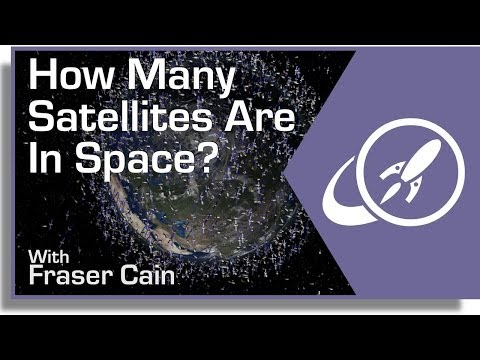
Artist's conception of the Mars 2020 rover. Credit: NASA
As Day 2 of the United States government shutdown continues, some short-term effects are already in evidence when it comes to Earth and space.
Most of the NASA and National Oceanic and Atmospheric Administration (NOAA) websites are offline. Social media updates are silent. At NASA, 97% of agency employees are off work and media reports indicate that 55% of NOAA’s employees are furloughed.
If the shutdown lasts for very long, however, long-term programs could feel the pain. This includes a couple of Mars missions NASA is developing, as well as Earth-based climate research and satellite observation from NOAA.
Mars 2020
A twin rover to Mars Curiosity, called Mars 2020 for now, is expected to leave for the Red Planet in 2020 and do investigations into past life and habitability. Planning is still in the early stages, but an announcement of opportunity for science investigators was supposed to happen on Oct. 8. Notices of intent were due Oct. 15.
“The preproposal conference, scheduled for 10/8, may be rescheduled and the due date for NOIs (currently 10/15) could be delayed, if the government is still shut down closer to those dates,” NASA officials wrote in an update before the shutdown on Monday.
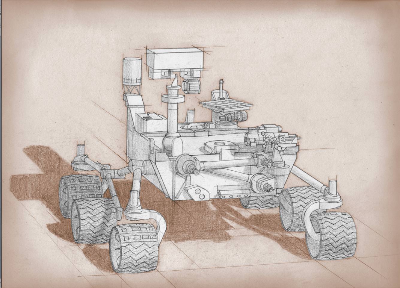
MAVEN team members, including chief scientist Bruce Jakosky (2nd from left) pose with spacecraft inside the cleanroom at the Kennedy Space Center on Sept. 27, 2013. Credit: Ken Kremer/kenkremer.com
MAVEN
As widely reported yesterday, the next Mars orbiter from NASA is expected to lift off from Earth on Nov. 18. Now, however, preparatory work has ceased and there is some concern from team members that it will miss the launch window, which extends into December. At worst, this means MAVEN’s launch could be delayed until 2016, when the next opportunity opens.
“The hardware is being safed, meaning that it will be put into a known, stable, and safe state,” Bruce Jakosky, MAVEN’s principal investigator, told Universe Today‘s Ken Kremer yesterday. “We’ll turn back on when told that we can. We have some margin days built into our schedule.”
NOAA
As with NASA, NOAA is keeping up with mission-critical activities — which in their case, includes weather forecasting. Long-term climate research, however, is reportedly being shelved.
“For example, Harold Brooks, a top tornado researcher who works at the National Severe Storms Laboratory in Norman, Okla., reported his furlough notice on Facebook on Tuesday,” Climate Central wrote on Oct. 1. “Much of the staff at NOAA’s Earth Systems Research Lab and the Geophysical Fluid Dynamics Laboratory, except for positions related to maintaining computing resources, have also been furloughed. Those two labs are heavily involved in NOAA’s climate research programs.”
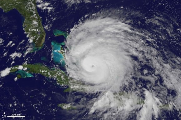
A view of Hurricane Irene taken by the GOES satellite at 2:55 p.m. Eastern Daylight Time on August 24, 2011. Credit: NASA
Observers are also worried that a lengthy shutdown could push back the time when new weather satellites become available. There have been multiple reports about a “weather satellite gap” coming in the United States as many of NOAA’s geostationary and polar-orbiting satellites are nearing the end of their expected lives. The Subcommittees on Oversight and Environment held hearings into this issue in September.
What’s still online?
These are some of the programs that are still happening at NASA and NOAA:
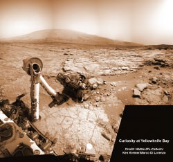
NASA’s Curiosity rover reaches out in ‘handshake’ like gesture with dramatic scenery of Mount Sharp in the background. This mosaic of images was snapped by Curiosity on Sol 262 (May 2, 2013) and shows her flexing the robotic arm. Two drill holes are visible on the surface bedrock below the robotic arm’s turret. Credit: NASA/JPL-Caltech/Ken Kremer-(kenkremer.com)/Marco Di Lorenzo
NASA:
Bare-bones management on programs such as the International Space Station and several robotic missions that are already in operation (such as the Lunar Atmosphere and Dust Environment Explorer (LADEE).
Certain missions are in critical phases that could be hurt if work stops, such as the James Webb Space Telescope, which is undergoing cryogenic testing on some of its instruments.
Several missions run out of the Jet Propulsion Laboratory and Applied Physics Laboratory are still running as usual, according to the Planetary Society, as these receive contract money from NASA; this means Mars Curiosity is still working, for example.
The Mars Reconnaissance Orbiter’s HiRISE camera is still snapping pictures, its Twitter account reported, which is positive given that it was intended to snap shots of Comet ISON during its closest approach to Mars yesterday.
The decades-long Landsat Earth observation program is still operating, according to The Atlantic, with data being sent back to Earth as usual. The difference is this information won’t be packaged as usual until government operations restart.
NOAA (all information according to this Department of Commerce document):
The Office of Oceanic and Atmospheric Research will keep 73 employees on board “to ensure continuity of crucial long-term historical climate records, and real-time regular research to support ongoing weather and air quality prediction services,” NOAA said.
184 employees will stay with the Environmental Satellite and Data Information Service for command and control of several satellites for NOAA and the Department of Defense.
474 employees will remain with the National Marine Fisheries Service. 174 are funded in another form besides appropriations. The others are a mix of law enforcement, fisheries management and property protection officials.
490 employees are with the Office of Marine and Aviation Operations for observational data collection related to weather forecasting.
173 employees are with the National Ocean Service. 17 are funded outside of appropriations, while the 156 remaining “are required to protect against imminent and significant threats to life and property by supporting safe maritime commerce in U.S. waters, including real-time water level data for ships entering U.S. ports, critical nautical chart updates, and accurate position information,” NOAA stated. Some are also monitoring marine health aspects such as algal blooms.
There are 19 IT-related employees and 20 employees providing support services.
The large bulk of employees still at work, 3,935 people, are with the National Weather Service to keep up weather forecasting.
There’s no word yet on when government employees could go back to work. Congress representatives are jousting over the implementation of a spending bill to keep the money flowing to government departments. One big issue: whether to include the Affordable Care Act, sometimes dubbed Obamacare, in the bill.
Another deadline is looming, too. Treasury Secretary Jack Lew has warned repeatedly that on Oct. 17, if the debt ceiling is not raised, the United States government may default on some financial obligations.
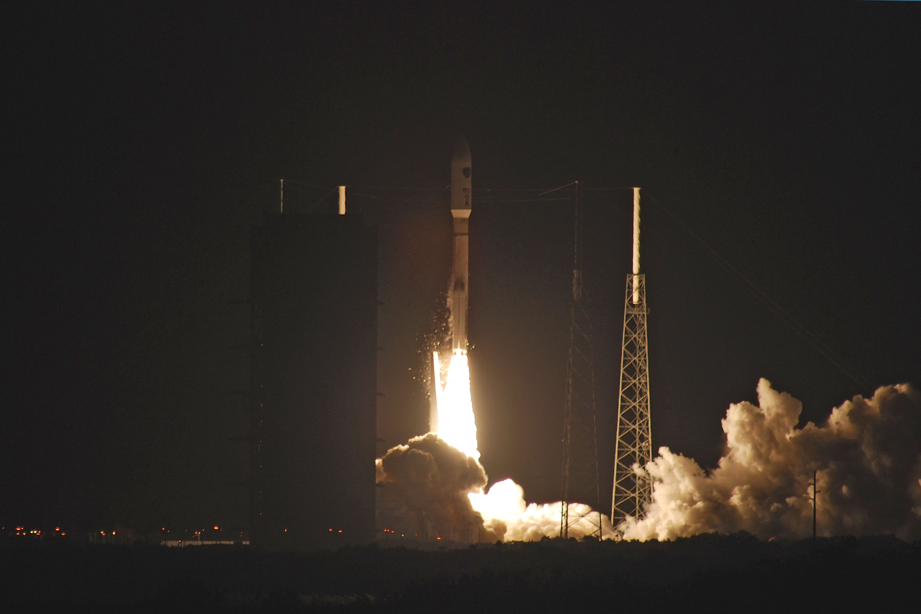
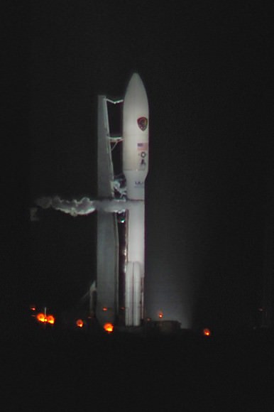
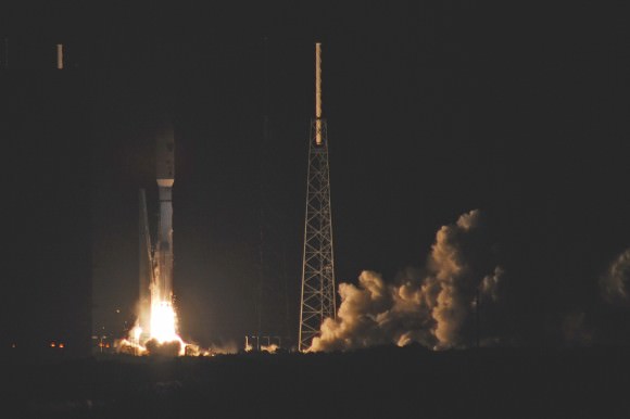
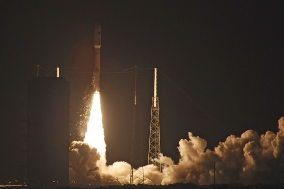
A United Launch Alliancee Atlas V rocet lifts off with the US Air Force’s third Advanced EHF satellite. Credit and copyright: John O’Connor/nasatech.net.
Early this morning a United Launch Alliance Atlas V rocket blasted off from Cape Canaveral in a gorgeous pre-dawn launch, sending the third Advanced Extremely High Frequency (AEHF-3) satellite for the United States Air Force to orbit. The rocket lifted off from Launch Complex-41 at 4:10 am EDT (08:10 UTC) on Wednesday, September 18, 2013. Thanks to John O’Connor from nasatech.net for sharing his beautiful launch images with Universe Today.
This launch leads the way for a second launch today: the historic Orbital Sciences Antares commercial rocket carrying the first fully functional Cygnus commercial resupply vehicle to orbit from NASA’s Wallops Island Facility on a demonstration mission bound for the International Space Station.
The AEHF-3 will provide a state-of-the-art communications system for the US military and Department of Defense.
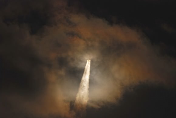
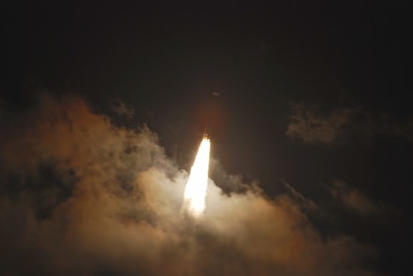
See more launches images below:
Awaiting its mission on Space Launch Complex 41, the Atlas 5 – 531/AEHF-3 stands ready as the weather slowly cleared. Credit and copyright: John O’Connor/nasatech.net,As the furious vibrations shake cascades of ice off of the liquid oxygen tank the Atlas 5-531 reaches for the sky and its supersynchronous transfer orbit. Credit and copyright: John O’Connor/nasatech.net.Halfway through the lightning wires, the Atlas 5 accelerates to its rendezvous with a supersynchronous transfer orbit. Credit and copyright: John O’Connor/nasatech.net.Through a cloud on its way to orbit, the Atlas 5 – 531 vehicle and it AEHF-3 payload dapple the clouds with light…. Credit and copyright: John O’Connor/nasatech.net.…and come out the top, amid the night, resplendent on a seething tower of dawn and thunder. Credit and copyright: John O’Connor/nasatech.net.
A 10 second exposure of a bright pass of the International Space Station. (Photo by Author).
It’s a question we get all the time.
Watch the sky closely in the dawn or dusk hours, and you’ll likely see a moving “star” or two sliding by. These are satellites, or “artificial moons” placed in low Earth orbit. These shine via reflected sunlight as they pass hundreds of kilometres overhead.
Many folks are unaware that you can see satellites with the naked eye. I always make an effort to watch for these during public star parties and point them out. A bright pass of the International Space Station if often as memorable as anything that can be seen through the eyepiece. But after this revelation, “the question” soon follows- “What satellite is that?”
Welcome to the wonderful and highly addictive world of satellite tracking. Ground observers have been watching the skies since Sputnik 1 and the first satellite launch in October 1957. Armies of dedicated volunteers even participated in tracking the early launches of the Space Age with Operation Moonwatch.
Depiction of the apparent motion of a typical satellite overhead with respect to the observer. (Graphic created by author).
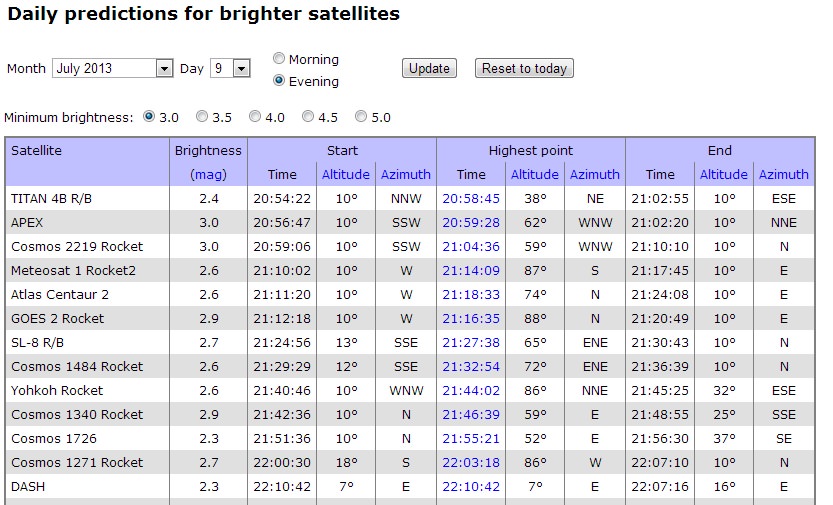
The Internet has offered a wealth of information for satellite hunters. Every time I write about “how to spot the ISS,” someone amazes me with yet another new tracker App that I hadn’t heard of. One of my favorites is still Heavens-Above. It’s strange to think that we’ve been visiting this outstanding website daily for a decade and a half now. Heavens-Above specializes in satellites, and will show you a quick listing of passes for brighter satellites once configured with your location. A nifty “quick check” for possibly resolving a mystery satellite is their link for “Daily Predictions for brighter satellites” Which will generate a list of visible passes by time.
Screenshot of a typical list of bright satellite passes from Heavens-Above filtered by brightness, time and location .
Looking at the time, direction, and brightness of a pass is crucial to satellite identification. No equipment is needed to start the hunt for satellites tonight, just a working set of eyes and information. We sometimes use a set of Canon image-stabilized 15x 45 binoculars to hunt for satellites too faint to see with the naked eye. We’ve seen the “Tool Bag” lost during an ISS EVA a few years back, as well as such “living relics” of the early Space Age as Canada’s first satellite Alloutte-1, and the Vanguards (Yes, they’re STILL up there!) using binocs.
A comparison of typical satellite orbits. (Credit: Cmglee, Geo Swan graphic under a Creative Commons Attribution -Share Alike 3.0 unported license).
The trick to catching fainter satellites such as these is to “ambush” them. You’ll need to note the precise time that the selected satellite is going to pass near a bright star. Clicking on a selected satellite pass in Heavens-Above will give you a local sky chart with a time-marked path. I use a short wave portable AM radio tuned to WWV out of Fort Collins, Colorado for an accurate audible time signal. Just sit back, listen to the radio call out the time, and watch for the satellite to pass through the field of view near the target star.
Another great site for more advanced trackers is CALSky. Like Heavens-Above, CALSky will give you a customized list for satellite passes over your location. One cool extra feature on CALSky is the ability to set alerts for passes of the ISS near bright planets or transiting the Sun or Moon. These are difficult events to capture, but worth it!
The International Space Station transiting the Moon as captured by Mike Weasner from Cassiopeia Observatory in Arizona.
A great deal of what’s up there is space junk in the form of discarded hardware. Many satellites are on looping elliptical orbits, only visible to the naked eye when they are near perigee. Many satellites are located out at geosynchronous or geostationary orbits 35,786 kilometres distant and are invisible to the naked eye all together. These will often show up as streaks in astrophotos. An area notorious for geosynchronous satellites exists near the direction of M42 or Orion Nebula. During certain times of year, satellites can be seen nearby, nodding slowly north to south and back again. Around the March and September equinox seasons, geostationary satellites can be eclipsed by the shadow of the Earth. This can also cause communications difficulties, as many geo-sats also lie sunward as seen from the Earth around these times of year.
Probably one of the simplest satellite trackers for casual users is Space Weather’s Satellite Flybys page. North American users simply need to enter a postal code (worldwide users can track satellites via entering “country-state-city”) and a list of passes for your location is generated.
It’s a basic truism of satellite tracking that “aircraft blink; satellites don’t”. Know, we’re going to present an exception to this rule.
Some satellites will flash rhythmically due to a tumbling motion. This can be pretty dramatic to see. What you’re seeing is an expended booster, a cylinder tumbling due to atmospheric drag end-over-end. Some satellites can flash or flare briefly due to sunlight glinting off of reflective surfaces just right. Hubble, the ISS and the late NanoSail D2 can flare if conditions are just right.
The most dramatic of these are Iridium flares. The Iridium constellation consists of 66 active satellites used for satellite phone coverage in low-Earth orbit. When one of their three refrigerator-sized antennas catch the Sun just right, they can flare up to magnitude -8, or 40 times brighter than Venus. CALSky and Heavens-Above will also predict these events for your location.
Didn’t see a predicted satellite pass? Light pollution or bright twilight skies might be to blame. Keep in mind, passes lower to the horizon also fall prey to atmospheric extinction, as you’re looking through a thicker layer of the air than straight overhead. Some satellites such as the ISS or the USAF’s X-37B spy space plane even periodically boost or modify their orbits, throwing online prediction platforms off for a time.
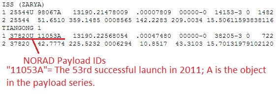
A screenshot example of TLE’s for the ISS & Tiangong-1 from Celestrak.
I use a free tracking platform created by Sebastian Stoff known as Orbitron. Orbitron lets you set your observing location and tailor your view for what’s currently over head. You can run simulations and even filter for “visual only” passes, another plus. I also like Orbitron’s ability to run as a stand-alone system in the field, sans Internet connection. Just remember, for it to work properly, you’ll need to periodically update the .txt file containing the Two-Line Element (TLE) sets. TLE’s are data element sets that describe the orbital elements of a satellite. Cut and paste TLEs are available from Heavens-Above and Celestrak.
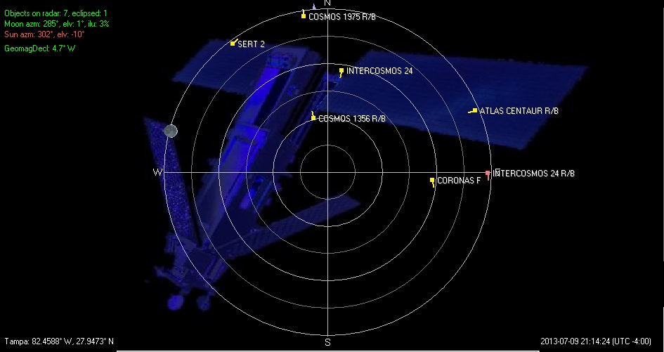
Orbitron screenshot for visible satellites using ‘radar’ mode… there’s lots up there! (Credit: Orbitron).
For serious users, NORAD’s Space-Track is the best site for up-to-date TLEs. Space-Track requires a login and user agreement to access, but is available to satellite spotters and educators as a valuable resource. Space-Track also hosts a table of upcoming reentries, as does the Aerospace Corporation’s Center for Orbital & Reentry Debris Studies.
The SeeSat-L mailing list is also an excellent source of discussion among satellite trackers worldwide. Increasingly, this discussion is also moving over to Twitter, which is ideal for following swiftly evolving action in orbit. @Twisst, created by Jaap Meijers,will even Tweet you prior to an ISS pass!
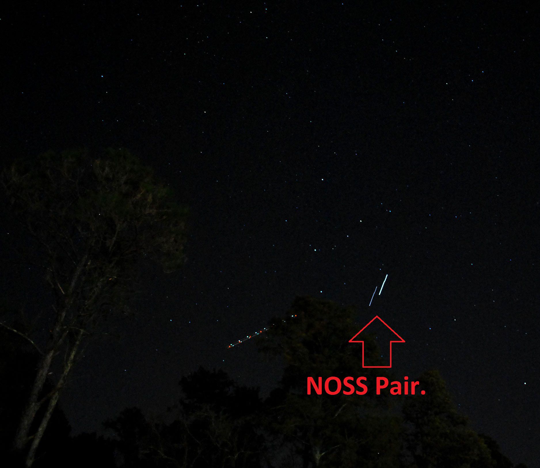
And there’s always something new or strange in the sky for the observant. Satellites such as those used in the Naval Ocean Surveillance System (NOSS) were launched in groups, and are eerie to watch as they move in formations of 2 or 3 across the sky. These are difficult to catch, and all three of our sightings thus far of a NOSS pair have been surreptitious. And we’ve only had the camera ready to swing into action once to nab a NOSS pair;
A NOSS pair captured by the author. The multi-colored trail to the left of the path is an aircraft. Note a bit of “jitter” at the beginning of the exposure- I had to swing the camera into action quickly!
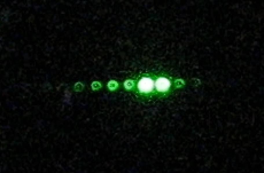
Another bizarre satellite to catch in action is known as the Cloud-Aerosol LiDAR & Infrared Pathfinder Satellite for Observations, or CALIPSO. Part of the “afternoon A-Train” of sun-synchronous Earth observing satellites, you can catch the green LiDAR flashes of CALIPSO from the ground with careful planning, just as Gregg Hendry did in 2008-2009:
A CALIPSO LiDAR pass imaged by Gregg Hendry in 2008. My Hendry mentions that, “The hollow nature of the spots is likely due to some spherical aberration in the camera lens coupled with imperfect focus, and is not representative of the laser beam’s optical quality.” (Credit: Gregg Hendry, used with permission).
NASA even publishes a prediction table for CALIPSO lidar passes. I wonder how many UFO sightings CALIPSO has generated?
Artist’s depiction of the A-Train constellation of Earth-Observing satellites. (Credit: NASA).
And speaking of photography, it’s easy to catch a bright pass such as the ISS on camera. Shooting a satellite pass with a wide field is similar to shooting star trails; just leave the shutter open for 10-60 seconds with a tripod mounted camera. Modern DSLRs allow you to do several test exposures prior to the pass, to get the ISO, f/stop, and shutter speed calibrated to local sky conditions.
You can even image the ISS through a telescope. Several sophisticated rigs exist to accurately track and image the space station through a scope, or you could use our decidedly low-tech but effective hand-guided method;
And that’s a brief overview of the exciting world of sat-spotting… let us know of your tales of triumph and tragedy as you sleuth out what’s going on overhead!
Look up into the night sky and count the moons. You can see only one moon, “the” Moon. But does the Earth have any other moons? Around the Solar System, multiple moons are the rule. Jupiter has 67 natural satellites, even Mars has two asteroid-like moons.
Could Earth have more than one?
Officially, the answer is no. The Earth has a single moon.
Today.
It’s possible Earth had more than one moon in the past, millions or even billions of years ago. Strange terrain on the far side of the Moon could be explained by a second moon crashing into it, depositing a layer of material tens of kilometers deep.
Moons could come and go over the billions of years of the Earth’s history.
For example, Mars has two Moons, but not for long. Phobos, the larger moon, is spiraling inward and expected to crash into the planet within the next 10 million years. And so, in the future, Mars will only have a single Moon, Deimos.
It’s also possible that the Earth might capture a Moon in the future. Neptune’s largest moon, Triton, orbits in the opposite direction from the rest of the moons around the planet. This suggests that Triton was actually a captured Kuiper Belt Object which strayed too close to the planet.
2006 RH120In fact, we did capture a 5-metre asteroid called 2006 RH120. It orbited the Earth four times during 2006/2007 before getting ejected again.
So we can assume events like this have happened in the past.
Additionally, we might have more moons, but they haven’t been discovered yet because they’re just too small. Researchers have calculated that there could be meter-sized asteroids in orbit around the Earth, remaining in orbit for hundreds of years before gravitational interactions push them out again.
And there are other objects that interact with Earth’s orbit in strange ways. Scientists don’t consider them moons, but they do stick around in our neighbourhood:
Asteroid 3753 Cruithne is in an orbital resonance with the Earth. It has a highly eccentric orbit, but takes exactly one year to orbit the Sun. From our perspective, it follows a slow, horse-shoe shaped path across the sky. Since the discovery of Cruithne in 1986, several other resonant near-Earth objects have been discovered.
2007 TK7There’s 2010 TK7, the Earth’s only known Trojan asteroid. It leads the Earth in the exact same orbit around the Sun, in a gravitationally stable point in space.
So, the answer… Earth only has a single Moon. Today. We might have had more moons in the past, and we might capture more in the future, but for right now… enjoy the one we’ve got.