Spectacular Billion Pixel Panorama from NASA’s Curiosity Mars Rover

This is a cropped, reduced version of panorama from NASA's Mars rover Curiosity with 1.3 billion pixels in the full-resolution version see full panorama below. It shows Curiosity at the "Rocknest" site where the rover scooped up samples of windblown dust and sand. Curiosity used three cameras to take the component images on several different days between Oct. 5 and Nov. 16, 2012. Viewers can explore this image with pan and zoom controls at http://mars.nasa.gov/bp1/. Credit: NASA/JPL-Caltech/MSSS

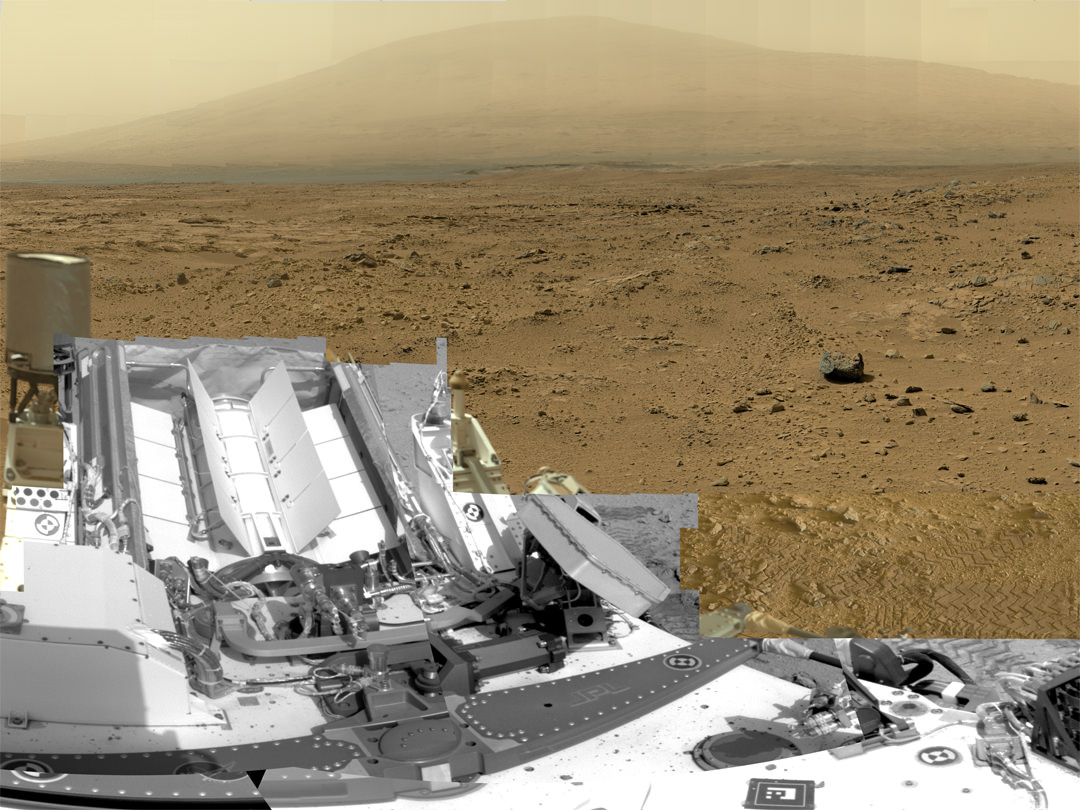
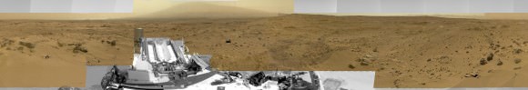
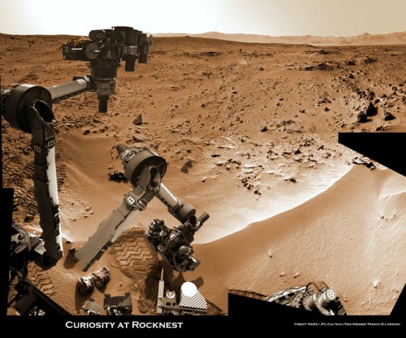
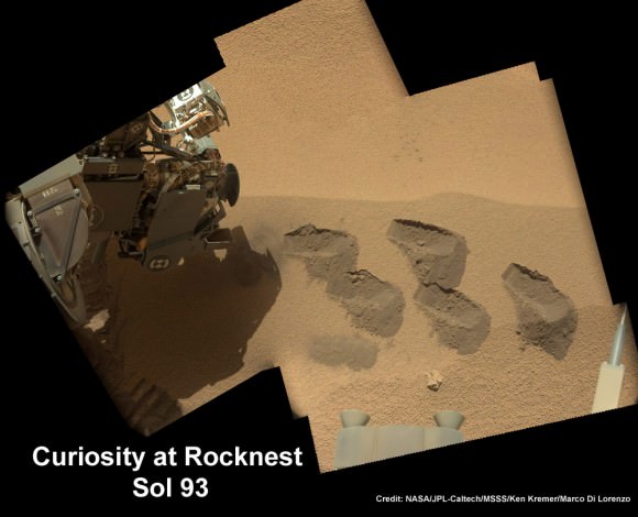
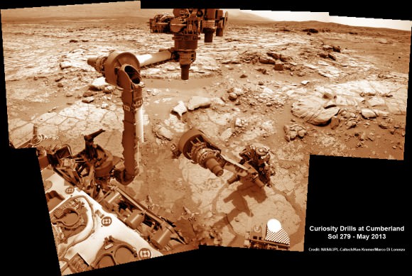
This is a cropped, reduced version of panorama from NASA’s Mars rover Curiosity with 1.3 billion pixels in the full-resolution version. See full panorama below. It shows Curiosity at the “Rocknest” site where the rover scooped up samples of windblown dust and sand. Curiosity used three cameras to take the component images on several different days between Oct. 5 and Nov. 16, 2012. Viewers can explore this image with pan and zoom controls at http://mars.nasa.gov/bp1/. Credit: NASA/JPL-Caltech/MSSS
Updated with link to interactive Gigapan version
[/caption]

NASA’s newly produced and absolutely spectacular panorama from the Curiosity mega rover offers armchair explorers back on Earth a mammoth 1.3 billion pixels worth of Mars in all its colorful glory.

And everyone can move back and forth around the interactive panorama and zoom in – with special embedded tools- to your hearts delight in exquisite detail at the ‘Rocknest’ site where the rover spent her first extended science stay in late 2012.

This extra special Rocknest panorama is the first NASA- produced view comprising more than a billion pixels from the surface of the Red Planet.

It offers a full 360 degree panoramic view around the rover encompassing breathtaking vistas of Mount Sharp and the eerie rim of Gale Crater, some 20 miles distant.

Mount Sharp rises 3.4 miles (5.5 km) high and is the target destination. The team hopes Curiosity will arrive at the base of Mount Sharp perhaps late this year or early in 2014.

The ‘Rocknest’ scene was assembled from nearly 900 raw images snapped by three different cameras among the 17 total that Curiosity uses as she trundles across the crater floor in search of the ingredients of life.

Billion-Pixel View From Curiosity at Rocknest, Raw Color.  This full-circle, reduced view combined nearly 900 images taken by NASA's Curiosity Mars rover, generating a panorama with 1.3 billion pixels in the full-resolution version. The view is centered toward the south, with north at both ends. It shows Curiosity at the "Rocknest" site where the rover scooped up samples of windblown dust and sand. Curiosity used three cameras to take the component images on several different days between Oct. 5 and Nov. 16, 2012. Credit: NASA/JPL-Caltech/MSSS
Billion-Pixel View From Curiosity at Rocknest, Raw Color. This full-circle, reduced view combined nearly 900 images taken by NASA’s Curiosity Mars rover, generating a panorama with 1.3 billion pixels in the full-resolution version. The view is centered toward the south, with north at both ends. It shows Curiosity at the “Rocknest” site where the rover scooped up samples of windblown dust and sand. Curiosity used three cameras to take the component images on several different days between Oct. 5 and Nov. 16, 2012. Credit: NASA/JPL-Caltech/MSSS

The panorama was created by Bob Deen of the Multi-Mission Image Processing Laboratory at NASA’s Jet Propulsion Laboratory, Pasadena, Calif, where the mission is managed on a daily basis.

“It gives a sense of place and really shows off the cameras’ capabilities,” said Deen in a statement. “You can see the context and also zoom in to see very fine details.”

Check here for the full, billion pixel interactive cylindrical and panoramic viewers

Download the full image –here.

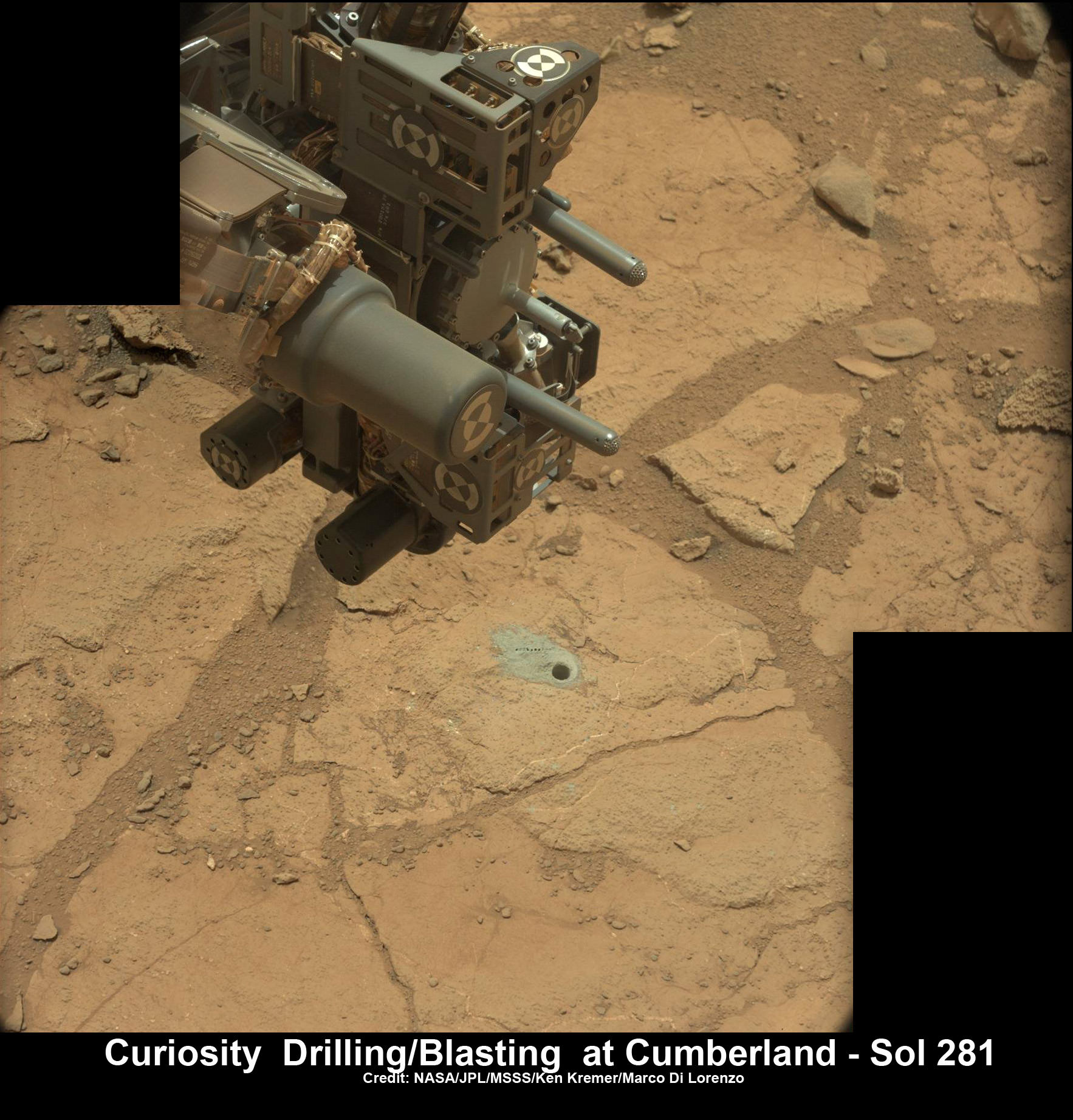
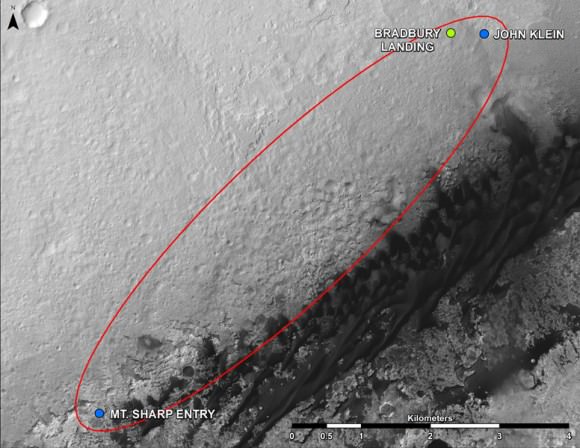
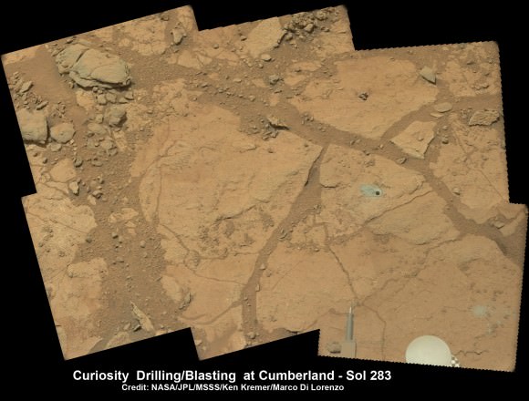
“Rocknest” was a windblown ripple of sand dunes that Curiosity drove to after departing from the touchdown site at ‘Bradbury Landing’ and thoroughly investigated in October and November 2012.

It was at ‘Rocknest’ where the six wheeled rover famously deployed her robotic arm to scoop into the Martian dirt for the very first time and then delivered those first grains to the duo of analytical chemistry labs inside her belly that lie at the heart of Curiosity’s science mission.

Deen assembled the color product using 850 raw images from the 100 mm telephoto camera of Curiosity’s Mast Camera instrument, supplemented with 21 more from the Mastcam’s wider-angle 34 mm camera.

In order to take in the rover itself, the view also included 25 black-and-white raw images from the Navigation Camera on the Mast.

All the images were taken between Oct. 5 and Nov. 16, 2012 while the rover was stationary at Rocknest.

Link to the interactive GigaPan version – here

And check this link to a new NASA JPL Curiosity gallery on the GigaPan website – here

Because the images were captured over many days and at different times of day, the lighting and atmospheric clarity varies – especially in distant views to the crater rim.

Since landing on August 6, 2012, Curiosity has already accomplished her primary goal of finding a habitable zone at Gale Crater with an environment that could once of supported Martian microbial life – at the current worksite at ‘Yellowknife Bay.’

Time lapse context view of Curiosity maneuvering her robotic arm to conduct close- up examination of windblown ‘Rocknest’ ripple site.  Curiosity inspects “bootlike” wheel scuff mark with the APXS (Alpha Particle X-Ray Spectrometer) and MAHLI (Mars Hand Lens Imager) instruments positioned on the rotatable turret at the arm’s terminus. Mosaic stitched from Navcam images on Sols 57 & 58 shows the arm in action just prior to 1st sample scooping here. Eroded rim of Gale Crater rim is visible on the horizon. Credit: NASA/JPL-Caltech/Ken Kremer (kenkremer.com)/Marco Di Lorenzo
Time lapse context view of Curiosity maneuvering her robotic arm to conduct close- up examination of windblown ‘Rocknest’ ripple site. Curiosity inspects “bootlike” wheel scuff mark with the APXS (Alpha Particle X-Ray Spectrometer) and MAHLI (Mars Hand Lens Imager) instruments positioned on the rotatable turret at the arm’s terminus. Mosaic stitched from Navcam images on Sols 57 & 58 shows the arm in action just prior to 1st sample scooping here. Eroded rim of Gale Crater rim is visible on the horizon. Credit: NASA/JPL-Caltech/Ken Kremer (kenkremer.com)/Marco Di Lorenzo

The 1 ton robot is equipped with 10 state-of-the-art science instruments with research capabilities that far surpass any prior landed mission and is in the middle of the 2-year primary mission to the Red Planet.

Meanwhile, Curiosity’s older sister rover Opportunity has also discovered clay minerals and a habitable zone on the opposite side of the Red Planet – details here.

And don’t forget to “Send Your Name to Mars” aboard NASA’s MAVEN orbiter- details here. Deadline: July 1, 2013

Ken Kremer

…………….
Learn more about Mars, Curiosity, Opportunity, MAVEN, LADEE and NASA missions at Ken’s upcoming lecture presentations

June 23: “Send your Name to Mars on MAVEN” and “CIBER Astro Sat, LADEE Lunar & Antares Rocket Launches from Virginia”; Rodeway Inn, Chincoteague, VA, 8 PM

Curiosity scooped 5 times into Martian soil at Rocknest windblown ripple and delivered samples to the SAM chemistry instrument for analysis. This color mosaic was stitched together from hi-res color images taken by the robots 34 mm Mastcam camera on Sols 93 and 74. Credit: NASA / JPL-Caltech /MSSS/Ken Kremer (kenkremer.com)/Marco Di Lorenzo

Did a Piece of Mir Really Land in Massachusetts?

Screenshot closeup of the Amesbury Mass. find.

We love a good space debris mystery. Hey, who doesn’t, right?  Regular readers of Universe Today know that it’s a shooting gallery out there, from meteor fireballs caught on dashboard cams to rogue space junk reentries lighting up our skies. 

But an unusual story that made its rounds across the internet this past weekend caught our attention. What at first glance was a simple “Man finds space rock” story morphed into an extraordinary claim, which, in the words of the late great Carl Sagan, “demand extraordinary evidence.”

The find was made by Phil Green of Amesbury, Massachusetts. Mr. Green was searching the local riverbed for arrowheads when he came across the unusual find. The black pitted rock immediately struck him as something bizarre.  It didn’t register as metallic to his metal detector, but Mr. Green kept it in his backyard for about five years until it was noticed by a friend.

“I didn’t really think much of it, and then a fellow came over, saw it and said that’s a meteor,” Green told local reporters.

From here, the story takes a strange turn. Green told local reporters that the rock was sent off for analysis, only to be returned to him just a few weeks ago. The analysis confirmed that the rock was indeed from space… sort of. It also stated that the vitreous material “shows a composition similar to that used in ballast by the Soviet space program starting in the mid-1980s.”

And the word was out. The media quickly ran with the “Man finds a piece of Mir” story.

There are just a few problems with the tale. Mir reentered in 2001, six years before the 2007. A few articles do bother to note this, mentioning that Mir ended its career in the “so-called spacecraft cemetery of the southern Pacific Ocean,” about as far away from Massachusetts as you can get.

A few articles do also mention the possibility of a reentry of a Progress resupply vehicle being a potential source, or perhaps an unrelated Russian space vehicle.

But there seems to be a potential problem of the certification. Several articles state that the piece of debris coming from Mir was “confirmed by NASA.” However, Universe Today contacted NASA Chief Scientist for Orbital Debris Nicholas L. Johnson and NASA Headquarters official Joshua Buck, who both told us that no such NASA validation exists. Mr. Johnson went on to tell Universe Today that, “The NASA Orbital Debris Program Office has not been presented with any claim regarding debris from the Mir space station,” adding “I can tell you that it is not possible for debris from the Mir reentry to have landed in the U.S.”

A name that occasionally turns up in reports online as validating the find (withheld by request) also tells Universe Today that they had nothing to do with the discovery. Mr. Green or the original validation source  have thus far been unavailable for comment.

We did uncover two documented reentries that occurred over the general region over the last few decades. One is the reentry of Mir-R 1986-017B (The rocket booster that launched the core module of Mir) seen from a trans-Atlantic airliner on February 24th 1986 about 500 kilometres off of the east coast of Newfoundland. Another possible suspect is the June 26/27th 2004 reentry of a SL-12 auxiliary rocket motor with the NORAD ID 1992-088E, seen to the west from New Jersey to Ontario.

Like the International Space Station, Mir was placed in a 51.6° inclined orbit. This made it accessible from the Baikonur Cosmodrome as well as visits from the U.S. Space Shuttle. Payloads going to and from the station would cover an identical ground track ranging from 51.6° north to south latitude.

The story is also reminiscent of the reentry of debris from Sputnik 4, which struck a small town in Wisconsin in 1962. This was analyzed by mineralogist Ursula Marvin and confirmed to be of Russian origin.

A Progress spacecraft inbound for docking with the International Space Station. (Credit: NASA).

Probably the biggest question in our minds is: what links the object back to an errant Russian spacecraft? What do they use for ballast, anyhow? How did they arrive at the often quoted “85% certainty?” of the object’s origin?

Still, the find does look like something interesting. The pitting and the melted fusion crust are all reminiscent of reentry. We’ll keep researching this story, and for the time being we’ll leave it up to you, the diligent and insightful readers of Universe Today, to make up your own minds on this strange and interesting tale.

Say Cheese: Cassini to Snap Another “Pale Blue Dot” Picture of Earth

Mosaic of Saturn seen in eclipse in September 2006. Earth is the bright dot just inside the F ring at upper left. (CICLOPS/NASA/JPL-Caltech/SSI)

Citizens of Earth, get ready for your Cassini close-up: once again the spacecraft is preparing to capture images of Saturn positioned between it and the Sun, allowing for incredible views of the ring system and its atmosphere — and also a tiny “pale blue dot” in the distance we call home.

Earth seen from Cassini (NASA/JPL/SSI)

The mosaic above was composed of images captured during such an eclipse event in September 2006, and quickly became an astronomical sensation. It’s not often we get an idea of what we look like from so far away, and seeing our entire world represented as a small speck of light nestled between Saturn’s rings is, to me anyway, both impressive and humbling.

Humbling because of how small we look, but impressive because as a species we have found a way to do it.

And next month, on Friday, July 19 between 21:27 and 21:42 UTC (5:27 – 5:42 p.m. EDT) Cassini will do it again.

“Ever since we caught sight of the Earth among the rings of Saturn in September 2006 in a mosaic that has become one of Cassini’s most beloved images, I have wanted to do it all over again, only better,” said Cassini imaging team leader, Carolyn Porco. “And this time, I wanted to turn the entire event into an opportunity for everyone around the globe, at the same time, to savor the uniqueness of our beautiful blue-ocean planet and the preciousness of the life on it.”

Porco was involved in co-initiating and executing the famous “Pale Blue Dot” image of Earth taken by NASA’s Voyager 1 from beyond the orbit of Neptune in 1990.

“It will be a day for all the world to celebrate,” she said.

The intent for the upcoming mosaic is to capture the whole scene, Earth and Saturn’s rings from one end to the other, in Cassini’s red, green and blue filters that can be composited to form a natural color view of what our eyes might see at Saturn. Earth and the Moon will also be imaged with a high resolution camera — something not yet done by Cassini.

We can all consider ourselves pretty lucky, too… this is the first time in history that we humans will know in advance that our picture is going to be taken from nearly a billion miles away.

“While Earth will be only about a pixel in size from Cassini’s vantage point 898 million miles [1.44 billion kilometers] away, the Cassini team is looking forward to giving the world a chance to see what their home looks like from Saturn,” said Linda Spilker, Cassini project scientist at NASA’s Jet Propulsion Laboratory. “With this advance notice, we hope you’ll join us in waving at Saturn from Earth, so we can commemorate this special opportunity.”

So on July 19, remember to look up and wave… Cassini will be watching!

Read more on the CICLOPS news release here and on the NASA/JPL Cassini mission site here.

“That’s here. That’s home. That’s us. On it everyone you love, everyone you know, everyone you ever heard of, every human being who ever was, lived out their lives… There is perhaps no better demonstration of the folly of human conceits than this distant image of our tiny world.”

– Carl Sagan

NASA Names First Astronaut Class for Deep Space Exploration

On Monday, NASA introduced eight new astronaut candidates – four women and four men – who will “help the agency push the boundaries of exploration and travel to new destinations in the solar system,” NASA said.

“This is the first class in three years, and the 21st overall in our nation’s nearly 55-year journey in space,” said NASA Associate Administrator Lori Garver in a blog post. “From a near-record number of applicants, more than 6,100, we selected an extremely qualified class that represents a high degree of achievement and dedication to our nation’s future.”

This is the highest percentage of female candidates ever selected for a class.

“That was not by choice or by determination,” said Janet Kavandi, a veteran astronaut and the director of Flight Crew Operations for NASA, speaking during a Google Plus Hangout where the new astronauts were introduced. “We never determine how many people of each gender we’re going to take, but these were the most qualified people of the ones that we interviewed. They earned every bit of the right to be there.”

Kavandi added that the new class is “an amazing group of people.”

You can watch a replay of the Hangout below:

The new astronauts candidates will undergo several years of training to become official astronauts. Right now NASA has 48 in the astronaut corps, which is about one-third the size it was at its peak a during the space shuttle heydays.

“With a smaller astronaut corps and fewer people in the office, now each person needs to have as diverse a background as possible” Kavandi said, “so we tried to work hard to make sure that the eight people we got had a broad spectrum of experiences, and I think you can tell that from their qualifications.”

NASA said the new astronauts will receive a wide array of technical training to prepare for missions to low-Earth orbit, an asteroid and Mars.

“These new space explorers asked to join NASA because they know we’re doing big, bold things here — developing missions to go farther into space than ever before,” said NASA Administrator Charles Bolden. “They’re excited about the science we’re doing on the International Space Station and our plan to launch from U.S. soil to there on spacecraft built by American companies. And they’re ready to help lead the first human mission to an asteroid and then on to Mars.”

The new astronaut candidates are:

Josh A. Cassada, Ph. D., 39, is originally from White Bear Lake, Minn. Cassada is a former naval aviator who holds an undergraduate degree from Albion College, and advanced degrees from the University of Rochester, N.Y. Cassada is a physicist by training and currently is serving as co-founder and Chief Technology Officer for Quantum Opus.

Victor J. Glover, 37, Lt. Commander, U.S. Navy, hails from Pomona, Calif., and Prosper, Texas. He is an F/A-18 pilot and graduate of the U.S. Air Force Test Pilot School. Glover holds degrees from California Polytechnic State University, San Luis Obispo, Calif.; Air University and Naval Postgraduate School. He currently is serving as a Navy Legislative Fellow in the U.S. Congress.

Tyler N. Hague (Nick), 37, Lt. Colonel, U.S. Air Force, calls Hoxie, Kan., home. He is a graduate of the U.S. Air Force Academy, Massachusetts Institute of Technology, and the U.S. Air Force Test Pilot School, Edwards, Calif. Hague currently is supporting the Department of Defense as Deputy Chief of the Joint Improvised Explosive Device Defeat Organization.

Christina M. Hammock, 34, calls Jacksonville, N.C. home. Hammock holds undergraduate and graduate degrees from North Carolina State University, Raleigh, N.C. She currently is serving as National Oceanic and Atmospheric Administration (NOAA) Station Chief in American Samoa.

Nicole Aunapu Mann, 35, Major, U.S. Marine Corps, originally is from Penngrove, Calif. She is a graduate of the U.S. Naval Academy, Stanford (Calif.) University and the U.S. Naval Test Pilot School, Patuxent River, Md. Mann is an F/A 18 pilot, currently serving as an Integrated Product Team Lead at the U.S. Naval Air Station, Patuxent River.

Anne C. McClain, 34, Major, U.S. Army, lists her hometown as Spokane, Wash. She is a graduate of the U.S. Military Academy at West Point, N.Y.; the University of Bath and the University of Bristol, both in the United Kingdom. McClain is an OH-58 helicopter pilot, and a recent graduate of U.S. Naval Test Pilot School at Naval Air Station, Patuxent River.

Jessica U. Meir, Ph.D., 35 is from Caribou, Maine. She is a graduate of Brown University, has an advanced degree from the International Space University, and earned her doctorate from Scripps Institution of Oceanography. Meir currently is an Assistant Professor of Anesthesia at Harvard Medical School, Massachusetts General Hospital, Boston.

Andrew R. Morgan, M.D., 37, Major, U.S. Army, considers New Castle, Pa., home. Morgan is a graduate of The U.S. Military Academy at West Point, and earned doctorate in medicine from the Uniformed Services University of the Health Sciences, Bethesda, Md. He has experience as an emergency physician and flight surgeon for the Army special operations community, and currently is completing a sports medicine fellowship.

You can read more about each of the astronauts here.

Black Hole Bonanza! Dozens (Potentially) Found In Andromeda As Another Study Probes X-Rays

A new analysis of data from the Chandra space telescope revealed 26 black hole candidates in the Andromeda Galaxy. This is the largest collection of possible black holes found in another galaxy besides that of the Milky Way, Earth's home galaxy. Credit: X-ray (NASA/CXC/SAO/R.Barnard, Z.Lee et al.), Optical (NOAO/AURA/NSF/REU Prog./B.Schoening, V.Harvey; Descubre Fndn./CAHA/OAUV/DSA/V.Peris)

More than two DOZEN potential black holes have been found in the nearest galaxy to our own. As if that find wasn’t enough, another research group is teaching us why extremely high-energy X-rays are present in black holes.

The Andromeda Galaxy (M31) is home to 26 newly found black hole candidates that were produced from the collapse of stars that are five to 10 times as massive as the sun.

Using 13 years of observations from NASA’s Chandra X-Ray Observatory, a research team pinpointed the locations. They also corroborated the information with X-ray spectra (distribution of X-rays with energy) from the European Space Agency’s XMM-Newton X-ray observatory.

“When it comes to finding black holes in the central region of a galaxy, it is indeed the case where bigger is better,” stated co-author Stephen Murray, an astronomer at Johns Hopkins University and the Harvard-Smithsonian Center for Astrophysics.

A close-up of the candidate black holes in Andromeda, as seen by the Chandra X-Ray Observatory. Credit: X-ray (NASA/CXC/SAO/R.Barnard, Z.Lee et al.), Optical (NOAO/AURA/NSF/REU Prog./B.Schoening, V.Harvey; Descubre Fndn./CAHA/OAUV/DSA/V.Peris

“In the case of Andromeda, we have a bigger bulge and a bigger supermassive black hole than in the Milky Way, so we expect more smaller black holes are made there as well,” Murray added.

The total number of candidates in M31 now stands at 35, since the researchers previously identified nine black holes in the area. All told, it’s the largest number of black hole candidates identified outside of the Milky Way.

Meanwhile, a study led by the NASA Goddard Space Flight Center examined the high-radiation environment inside a black hole — by simulation, of course. The researchers performed a supercomputer modelling of gas moving into a black hole, and found that their work helps explain some mysterious X-ray observations of recent decades.

Researchers distinguish between “soft” and “hard” X-rays, or those X-rays that have low and high energy. Both types have been observed around black holes, but the hard ones puzzled astronomers a bit.

Here’s what happens inside a black hole, as best as we can figure:

– Gas falls towards the singularity, orbits the black hole, and gradually becomes a flattened disk;

– As gas piles up in the center of the disk, it compresses and heats up;

– At a temperature of about 20 million degrees Fahrenheit (12 million degrees Celsius), the gas emits “soft” X-rays.

So where did the hard X-rays — that with energy tens or even hundreds of times greater than soft X-rays — come from? The new study showed that magnetic fields are amplified in this environment that then “exerts additional influence” on the gas, NASA stated.

Artist's conception of the Chandra X-Ray Observatory. Credit: NASA
Artist’s conception of the Chandra X-Ray Observatory. Credit: NASA

“The result is a turbulent froth orbiting the black hole at speeds approaching the speed of light. The calculations simultaneously tracked the fluid, electrical and magnetic properties of the gas while also taking into account Einstein’s theory of relativity,” NASA stated.

One key limitation of the study was it modelled a non-rotating black hole. Future work aims to model one that is rotating, NASA added.

You can check out more information about these two studies below:

– Andromeda black holes: Chandra identification of 26 new black hole candidates in the central region of M31. (Also available in the June 20 edition of The Astrophysical Journal.)

– X-ray modelling of black holes: X-ray Spectra from MHD Simulations of Accreting Black Holes. (Also available in the June 1 edition of The Astrophysical Journal.)

Sources: Chandra X-Ray Observatory and NASA

Curiosity Gets Set for Epic Drive after Laser Blasting Mars Watery Secrets

Curiosity’s hi tech ‘hand’ and percussion drill hovers above 2nd bore hole at Cumberland mudstone rock after penetrating laser blasting to unlock secrets of ancient flow of Martian water. Photo mosaic assembled from high resolution Mastcam images on May 21, 2013, Sol 281. Credit: NASA/JPL-Caltech/MSSS/Ken Kremer (kenkremer.com)/Marco Di Lorenzo

Ten months after her breathtaking touchdown on the Red Planet, NASA’s Curiosity rover is nearly set to embark on an epic drive like no other in space history to the slopes of mysterious Mount Sharp – looming supreme inside Gale Crater and the primary mission objective.

But not before the robot completes a few last critical science tasks to more fully illuminate the potential for the origin of Martian microbes in the habitable zone discovered at the work-site of her first penetrations into Mars water altered surface.

The rover science team has chosen a trio of final targets to investigate around the shallow basin of Yellowknife Bay, that resembles a dried out lakebed, where Curiosity has toiled for the past six months, drilled twice into the mudstone outcrops at ‘John Klein’ and ‘Cumberland’ and repeatedly fired her powerful science laser.

Curiosity will revisit a pair of intriguing outcrops named ‘Point Lake’ and ‘Shaler’ that the rover briefly investigated before arriving at ‘John Klein’, said Joy Crisp of JPL, Curiosity’s deputy project scientist, at a media briefing.

“Shaler might be a river deposit. Point Lake might be volcanic or sedimentary. A closer look at them could give us better understanding of how the rocks we sampled with the drill fit into the history of how the environment changed.”

Curiosity will employ nearly all her science instruments to study the outcrops – except the drill.

“It’s highly unlikely to drill at ‘Point Lake’ and ‘Shaler’ because we want to get driving,” Crisp told Universe Today.

“We might drill somewhere along the way to Mount Sharp depending on whether we find something compelling.”

'Point Lake' Outcrop in Gale Crater.  A priority target for a closer look byCuriosity before the rover departs the "Glenelg" area east of its landing site. The pitted outcrop called "Point Lake" is about 7 feet (2 meters) wide and 20 inches (50 centimeters) high.  A closer inspection may yield information about whether it is a volcanic or sedimentary deposit. Credit: NASA/JPL-Caltech/MSSS
‘Point Lake’ Outcrop in Gale Crater. A priority target for a closer look byCuriosity before the rover departs the “Glenelg” area east of its landing site. The pitted outcrop called “Point Lake” is about 7 feet (2 meters) wide and 20 inches (50 centimeters) high. A closer inspection may yield information about whether it is a volcanic or sedimentary deposit. Credit: NASA/JPL-Caltech/MSSS

Researchers will also use the DAN (Dynamic Albedo of Neutrons) instrument to look for traces of mineral bound water – in the form of hydrogen – at the boundary between bedrock areas of mudstone and sandstone.

Thereafter, Curiosity’s handlers will command the 1 ton behemoth to begin the drive to the lower reaches of Mount Sharp which lies about 6 miles (10 kilometers) distant – as the Martian crow flies.

Mount Sharp rises about 3.4 miles (5.5 km) from the center of Gale Crater. It’s taller than Mount Ranier in Washington State.

Billions of years of Mars geologic history are preserved in the sedimentary layers of Mount Sharp – along with potential signatures of the chemical ingredients of life.

Curiosity Route Map From 'Glenelg' to Mount Sharp. This map shows where NASA's Mars rover Curiosity landed in August 2012 at "Bradbury Landing"; the area where the rover worked from November 2012 through May 2013 at and near the "John Klein" target rock in the "Glenelg" area; and the mission's next major destination, the entry point to the base of Mount Sharp.  Credit: NASA/JPL-Caltech/Univ. of Arizona
Curiosity Route Map From ‘Glenelg’ to Mount Sharp.
This map shows where NASA’s Mars rover Curiosity landed in August 2012 at “Bradbury Landing”; the area where the rover worked from November 2012 through May 2013 at and near the “John Klein” target rock in the “Glenelg” area; and the mission’s next major destination, the entry point to the base of Mount Sharp. Credit: NASA/JPL-Caltech/Univ. of Arizona

“The drive will start in a few weeks,” said Curiosity Project Manager Jim Erickson of NASA’s Jet Propulsion Laboratory, Pasadena, Calif. at the briefing.

But the team will be on the lookout for targets of opportunity along the way.

“We are on a mission of exploration. If we come across scientifically interesting areas, we are going to stop and examine them before continuing the journey,” Erikson added.

“If we pass something amazing and compelling we might turn around and drive back,” Crisp added.

It could take nearly a year to arrive at Mount Sharp. And Curiosity must pass through a potentially treacherous dune field to get there – see NASA JPL route map above.

“We are looking for the best path though,” said Erickson.

NASA chose Gale as the landing site specifically to dispatch Curiosity to investigate the sedimentary layers of Mount Sharp because it exhibited signatures of clay minerals that form in neutral water and that could possibly support the origin and evolution of simple Martian life forms, past or present.

“We have a real desire to get to Mount Sharp because there we see variations in the mineralogy as we go up from the base to higher levels and a change in the record of the environment,” said Crisp.

Analysis of the initial gray colored, powdery ‘John Klein’ sample by Curiosity’s pair of onboard chemistry labs – SAM & Chemin – revealed that this location on Mars was habitable in the past and possesses the key chemical ingredients – such as clay minerals – required to support microbial life forms- thereby successfully accomplishing the key science objective of the mission and making a historic discovery long before even arriving at destination Mount Sharp.

Besides the science measurements, researchers also learned lot about how to operate the complex drilling and sample delivery mechanisms much more efficiently for the second drilled rock sample.

The sieved and pulverized Cumberland sample was delivered in about a quarter of the time compared to the John Klein sample – accomplished at a deliberately measured and cautious pace.

Context view of Curiosity’s 2nd drill site at Cumberland rock on the floor of Yellowknife Bay basin of ancient water altered rocks where the rover found environmental conditions favorable for microbial life. Mastcam images on May 23, 2013, Sol 283.  Credit: NASA/JPL-Caltech/MSSS/Ken Kremer (kenkremer.com)/Marco Di Lorenzo
Context view of Curiosity’s 2nd drill site at Cumberland rock on the floor of Yellowknife Bay basin showing ancient water altered rocks where the rover found environmental conditions favorable for microbial life. Mastcam images on May 23, 2013, Sol 283. Credit: NASA/JPL-Caltech/MSSS/Ken Kremer (kenkremer.com)/Marco Di Lorenzo

Analysis of the “Cumberland” powder is currently in progress. The goal is to determine how it compares chemically and to confirm the results found at ‘John Klein.’

“No results from Cumberland are available yet,” said Crisp.

The robot used the powerful million watt ChemCam laser to blast into the Cumberland drill hole and gray tailings scattered on the surface to glean as much insight and measurements of the chemical composition and transformation by water as possible before departing.

Curiosity has just arrived at “Point Lake’. Stay tuned for my next Curiosity story.

Meanwhile, Curiosity’s older sister rover Opportunity has likewise discovered clay minerals and a habitable zone on the opposite side of the Red Planetdetails here.

And don’t forget to “Send Your Name to Mars” aboard NASA’s MAVEN orbiter- details here. Deadline: July 1, 2013

Ken Kremer

…………….

Learn more about Mars, Curiosity, Opportunity, MAVEN, LADEE and NASA missions at Ken’s upcoming lecture presentations

June 23: “Send your Name to Mars on MAVEN” and “CIBER Astro Sat, LADEE Lunar & Antares Rocket Launches from Virginia”; Rodeway Inn, Chincoteague, VA, 8 PM

This time lapse mosaic shows Curiosity moving her robotic arm to drill into her 2nd rockt target named “Cumberland” to collect powdery material on May 19, 2013 (Sol 279) for analysis by her onboard chemistry labs; SAM & Chemin. The photomosaic was stitched from raw images captured by the navcam cameras on May 14 & May 19 (Sols 274 & 279).  Credit: NASA/JPL-Caltech/Ken Kremer/Marco Di Lorenzo
This time lapse mosaic shows Curiosity moving her robotic arm to drill into her 2nd rockt target named “Cumberland” to collect powdery material on May 19, 2013 (Sol 279) for analysis by her onboard chemistry labs; SAM & Chemin. The photomosaic was stitched from raw images captured by the navcam cameras on May 14 & May 19 (Sols 274 & 279). Credit: NASA/JPL-Caltech/Ken Kremer/Marco Di Lorenzo

Navy Researchers Put Dark Lightning to the SWORD

Dark lightning occurs within thunderstorms and flings gamma rays and antimatter into space. (Science@NASA video)

Discovered “by accident” by NASA’s Fermi Gamma-ray Space Telescope in 2010, dark lightning is a surprisingly powerful — yet invisible — by-product of thunderstorms in Earth’s atmosphere. Like regular lightning, dark lightning is the result of a natural process of charged particles within storm clouds trying to cancel out opposing charges. Unlike normal lightning, though, dark lightning is invisible to our eyes and doesn’t radiate heat or light — instead, it releases bursts of gamma radiation.

What’s more, these gamma-ray outbursts originate at relatively low altitudes well within the storm clouds themselves. This means that airplane pilots and passengers flying through thunderstorms may be getting exposed to gamma rays from dark lightning, which are energetic enough to pass through the hull of an aircraft… as well as anything or anyone inside it. To find out how such exposure to dark lightning could affect air travelers, the U.S. Naval Research Laboratory (NRL) is conducting computer modeling tests using their SoftWare for the Optimization of Radiation Detectors — SWORD, for short.

Terrestrial Gamma-ray Flashes (TGFs) are extremely intense, sub-millisecond bursts of gamma rays and particle beams of matter and anti-matter. First identified in 1994, they are associated with strong thunderstorms and lightning, although scientists do not fully understand the details of the relationship to lightning. The latest theoretical models of TGFs suggest that the particle accelerator that creates the gamma rays is located deep within the atmosphere, at altitudes between six and ten miles, inside thunderclouds and within reach of civilian and military aircraft.

These models also suggest that the particle beams are intense enough to distort and collapse the electric field within thunderstorms and may, therefore, play an important role in regulating the production of visible lightning. Unlike visible lightning, TGF beams are sufficiently broad — perhaps about half a mile wide at the top of the thunderstorm — that they do not create a hot plasma channel and optical flash; hence the name, “dark lightning.”

A team of NRL Space Science Division researchers, led by Dr. J. Eric Grove of the High Energy Space Environment (HESE) Branch, is studying the radiation environment in the vicinity of thunderstorms and dark lightning flashes. Using the Calorimeter built by NRL on NASA’s Fermi Gamma-ray Space Telescope they are measuring the energy content of dark lightning and, for the first time, using gamma rays to geolocate the flashes.

As a next step, Dr. Chul Gwon of the HESE Branch is using NRL’s SoftWare for the Optimization of Radiation Detectors (SWORD) to create the first-ever simulations of a dark lightning flash striking a Boeing 737. He can calculate the radiation dosage to the passengers and crew from these Monte Carlo simulations. Previous estimates have indicated it could be as high as the equivalent of hundreds of chest X-rays, depending on the intensity of the flash and the distance to the source.

Simulation of a Boeing 737 struck by dark lightning. Green tracks show the paths of gamma rays from the dark flash as they enter the aircraft from below.   (Credit: U.S. Naval Research Laboratory)
Simulation of a Boeing 737 struck by dark lightning. Green tracks show the paths of gamma rays from the dark flash as they enter the aircraft from below.
(Credit: U.S. Naval Research Laboratory)

SWORD simulations allow researchers to study in detail the effects of variation in intensity, spectrum, and geometry of the flash. Dr. Grover’s team is now assembling detectors that will be flown on balloons and specialized aircraft into thunderstorms to measure the gamma ray flux in situ. The first balloon flights are scheduled to take place this summer.

Source: NRL News

An Early Start for Noctilucent Clouds

Noctilucent clouds photographed over Killygordon, Ireland on the morning of June 10. (© Brendan Alexander/Donegal Skies. All rights reserved.)

The season for noctilucent “night-shining” clouds is arriving in the northern hemisphere, when wispy, glowing tendrils of high-altitude ice crystals may be seen around the upper latitudes, shining long after the Sun has set. Found about 83 km (51 miles) up, noctilucent clouds (also called polar mesospheric clouds) are the highest cloud formations in the atmosphere. They’ve been associated with rocket launches and space shuttle re-entries and are now thought to also be associated with meteor activity… and for some reason, this year they showed up a week early.


Noctilucent clouds (NLCs) form between 76 to 85 kilometers (47 to 53 miles) above Earth’s surface when there is just enough water vapor to freeze into ice crystals. The icy clouds are illuminated by the Sun when it is just below the horizon, after darkness has fallen, giving them their night-shining properties. This year NASA’s AIM spacecraft, which is orbiting Earth on a mission to study high-altitude ice, started seeing noctilucent clouds on May 13th.

AIM map of noctilucent clouds over the north pole on June 8 (Credit: LASP/University of Colorado)
AIM map of noctilucent clouds over the north pole on June 8
(Credit: LASP/University of Colorado)

“The 2013 season is remarkable because it started in the northern hemisphere a week earlier than any other season that AIM has observed,” reports Cora Randall of the Laboratory for Atmospheric and Space Physics at the University of Colorado. “This is quite possibly earlier than ever before.”

The early start is extra-puzzling because of the solar cycle. Researchers have long known that NLCs tend to peak during solar minimum and bottom-out during solar maximum — a fairly strong anti-correlation. “If anything, we would have expected a later start this year because the solar cycle is near its maximum,” Randall says. “So much for expectations.”

Read more on the NASA AIM page here, and watch the Science@NASA video below for the full story. (Also, check out some very nice NLC photos taken last week in the UK by Stuart Atkinson at Cumbrian Sky.)

Source: NASA

10 Years & Top 10 Discoveries from Marvelous Mars Express

Mars Express over water-ice crater. ESA Celebrates 10 Years since the launch of Mars Express. This artists concept shows Mars Express set against a 35 km-wide crater in the Vastitas Borealis region of Mars at approximately 70.5°N / 103°E. The crater contains a permanent patch of water-ice that likely sits upon a dune field – some of the dunes are exposed towards the top left in this image. Copyright ESA/DLR/FU-Berlin-G.Neukum

This week marks the 10th anniversary since the launch of the European Space Agencies’ (ESA) Mars Express orbiter from the Baikonur Cosmodrome in Russia on June 2, 2003 and a decade of ground breaking science discoveries at the Red Planet.

2003 was a great year for Mars exploration as it also saw the dual liftoffs of NASA’s now legendary rovers Spirit & Opportunity from Cape Canaveral in Florida.

The immense quantity and quality of science data returned from Mars Express -simultaneously with Spirit and Opportunity – has completely transformed our understanding of the history and evolution of the Red Planet.

All three spacecraft have functioned far beyond their original design lifetime.

Earth’s exploration fleet of orbiters, landers and rovers have fed insights to each other that vastly multiplied the science output compared to working solo during thousands and thousands of bonus Sols at Mars.

Inside a central pit crater.  Perspective view of a 50 km diameter crater in Thaumasia Planum. The image was made by combining data from the High-Resolution Stereo Camera on ESA’s Mars Express with digital terrain models. The image was taken on 4 January 2013, during orbit 11467, and shows a close up view of the central ‘pit’ of this crater, which likely formed by a subsurface explosion as the heat from the impact event rapidly vapourised water or ice lying below the surface. Copyright ESA/DLR/FU-Berlin-G.Neukum
Inside a central pit crater. Perspective view of a 50 km diameter crater in Thaumasia Planum. The image was made by combining data from the High-Resolution Stereo Camera on ESA’s Mars Express with digital terrain models. The image was taken on 4 January 2013, during orbit 11467, and shows a close up view of the central ‘pit’ of this crater, which likely formed by a subsurface explosion as the heat from the impact event rapidly vapourised water or ice lying below the surface. Copyright ESA/DLR/FU-Berlin-G.Neukum

Mars Express derived its name from an innovative new way of working in planetary space science that sped up the development time and cut costs in the complex interactive relationships between the industrial partners, space agencies and scientists.

Indeed the lessons learned from building and operating Mars Express spawned a sister ship, Venus Express that also still operates in Venusian orbit.

Mars Express (MEX) achieved orbit in December 2003.

MEX began science operations in early 2004 with an array of seven instruments designed to study all aspects of the Red Planet, including its atmosphere and climate, and the mineralogy and geology of the surface and subsurface with high resolution cameras, spectrometers and radar.

The mission has been granted 5 mission extensions that will carry it to at least 2014.

The mission has been wildly successful except for the piggybacked lander known as Beagle 2, which was British built.

Beagle 2
Beagle 2
The ambitious British lander was released from the mothership on December 19, 2003, six days before MEX braked into orbit around Mars. Unfortunately the Beagle 2 was never heard from again as it plummeted to the surface and likely crashed.

The high resolution camera (HRSC) has transmitted thousands of dramatic 3D images all over Mars ranging from immense volcanoes, steep-walled canyons, dry river valleys, ancient impact craters of all sizes and shapes and the ever-changing polar ice caps.

It carried the first ever radar sounder (MARSIS) to orbit another planet and has discovered vast caches of subsurface water ice.

MEX also played a significant role as a data relay satellite for transmissions during the landings of NASA’s Phoenix lander and Curiosity rover. It also occasionally relays measurements from Spirit & Opportunity to NASA.

Arima twins topography. This colour-coded overhead view is based on an ESA Mars Express High-Resolution Stereo Camera digital terrain model of the Thaumasia Planum region on Mars at approximately 17°S / 296°E. The image was taken during orbit 11467 on 4 January 2013. The colour coding reveals the relative depth of the craters, in particular the depths of their central pits, with the left-hand crater penetrating deeper than the right (Arima crater).  Copyright: ESA/DLR/FU-Berlin-G.Neukum
Arima twins topography. This colour-coded overhead view is based on an ESA Mars Express High-Resolution Stereo Camera digital terrain model of the Thaumasia Planum region on Mars at approximately 17°S / 296°E. The image was taken during orbit 11467 on 4 January 2013. The colour coding reveals the relative depth of the craters, in particular the depths of their central pits, with the left-hand crater penetrating deeper than the right (Arima crater). Copyright: ESA/DLR/FU-Berlin-G.Neukum

Here is a list of the Top 10 Discoveries from Mars Express from 2003 to 2013:

Mars Express mineralogy maps. This series of five maps shows near-global coverage of key minerals that help plot the history of Mars. The map of hydrated minerals indicates individual sites where a range of minerals that form only in the presence of water were detected. The maps of olivine and pyroxene tell the story of volcanism and the evolution of the planet’s interior. Ferric oxides, a mineral phase of iron, are present everywhere on the planet: within the bulk crust, lava outflows and the dust oxidised by chemical reactions with the martian atmosphere, causing the surface to ‘rust’ slowly over billions of years, giving Mars its distinctive red hue. Copyright:  ESA/CNES/CNRS/IAS/Université Paris-Sud, Orsay; NASA/JPL/JHUAPL; Background images: NASA MOLA
Mars Express mineralogy maps. This series of five maps shows near-global coverage of key minerals that help plot the history of Mars. The map of hydrated minerals indicates individual sites where a range of minerals that form only in the presence of water were detected. The maps of olivine and pyroxene tell the story of volcanism and the evolution of the planet’s interior. Ferric oxides, a mineral phase of iron, are present everywhere on the planet: within the bulk crust, lava outflows and the dust oxidised by chemical reactions with the martian atmosphere, causing the surface to ‘rust’ slowly over billions of years, giving Mars its distinctive red hue. Copyright: ESA/CNES/CNRS/IAS/Université Paris-Sud, Orsay; NASA/JPL/JHUAPL; Background images: NASA MOLA
#1. First detection of hydrated minerals in the form of phyllosilicates and hydrated sulfates – evidence of long periods of flowing liquid water from the OMEGA visible and infrared spectrometer provided confirmation that Mars was once much wetter than it is today and may have been favorable for life to evolve.

#2. Possible detection of methane in the atmosphere from the Planetary Fourier Spectrometer (PFS) which could originate from biological or geological activity.

#3. Identification of recent glacial landforms via images from the High Resolution Stereo Camera (HRSC) are stem from viscous flow features composed of ice-rich material derived from adjacent highlands.

#4. Probing the polar regions. OMEGA and MARSIS determined that the south pole consists of a mixture frozen water ice and carbon dioxide. If all the polar ice melted the planet would be covered by an ocean 11 meters deep.

#5. Recent and episodic volcanism perhaps as recently as 2 million years ago. Mars has the largest volcanoes in the solar system . They are a major factor in the evolution of the martian surface, atmosphere and climate.

#6. Estimation of the current rate of atmospheric escape, helps researchers explain how Mars changed from a warm, wet place to the cold, dry place it is today.

#7. Discovery of localised aurora on Mars

#8. A new, meteoric layer in the martian ionosphere created by fast-moving cosmic dust which burns up as it hits the atmosphere.

#9. Unambiguous detection of carbon dioxide clouds. The freezing and vaporisation of CO2 is one of the main climatic cycles of Mars, and it controls the seasonal variations in surface air pressure.

#10. Unprecedented probing of the Martian moon Phobos – which could be a target for future landers and human missions.

The Mars-facing side of Phobos. Credit: ESA/DLR/FU Berlin (G. Neukum)

And don’t forget to “Send Your Name to Mars” aboard NASA’s MAVEN orbiter- details here. Deadline: July 1, 2013

Ken Kremer

…………….
Learn more about Conjunctions, Mars, Curiosity, Opportunity, MAVEN, LADEE, CIBER and NASA missions at Ken’s upcoming lecture presentations

June 11: “Send your Name to Mars on MAVEN” and “LADEE Lunar & Antares Rocket Launches from Virginia”; NJ State Museum Planetarium and Amateur Astronomers Association of Princeton (AAAP), Trenton, NJ, 730 PM.

June 12: “Send your Name to Mars on MAVEN” and “LADEE Lunar & Antares Rocket Launches from Virginia”; Franklin Institute and Rittenhouse Astronomical Society, Philadelphia, PA, 8 PM.

June 23: “Send your Name to Mars on MAVEN” and “CIBER Astro Sat, LADEE Lunar & Antares Rocket Launches from Virginia”; Rodeway Inn, Chincoteague, VA, 8 PM

What Does Antarctica Look Like Under the Ice?

New topography map of Antarctica by the British Antarctic Survey's Bedmap2 (NASA/GSFC)

Although it sits isolated at the “bottom of the world” Antarctica is one of the most influential continents on Earth, affecting weather, climate, and ocean current patterns over the entire planet. But Antarctica is also one of the most enigmatic landmasses too, incredibly remote, extremely harsh, and covered by a layer of ice over 2 km thick. And as Earth’s global temperature continues to climb steadily higher, the future of ice in Antarctica — a continent half again as large as the contiguous United States — is a big concern for scientists… but in order to know exactly how its ice will behave to changing conditions, they need to know what’s under it.

This is where the British Antarctic Survey — using data gathered by NASA’s ICESat and Operation IceBridge missions — comes in, giving us a better view of what lies beneath the southern continent’s frozen veil.

A new dataset called Bedmap2 gives a clearer picture of Antarctica from the ice surface down to the bedrock below. Bedmap2 is a significant improvement on the previous collection of Antarctic data — known as Bedmap — that was produced more than 10 years ago. The product was a result of work led by the British Antarctic Survey, where researchers compiled decades worth of geophysical measurements, such as surface elevation measurements from NASA’s Ice, Cloud and Land Elevation Satellite (ICESat) and ice thickness data collected by Operation IceBridge.

Bedmap2, like the original Bedmap, is a collection of three datasets—surface elevation, ice thickness and bedrock topography. Both Bedmap and Bedmap2 are laid out as grids covering the entire continent, but with a tighter grid spacing Bedmap2 includes many surface and sub-ice features too small to be seen in the previous dataset. Additionally, the extensive use of GPS data in more recent surveys improves the precision of the new dataset.

Improvements in resolution, coverage and precision will lead to more accurate calculations of ice volume and potential contribution to sea level rise.

Ice sheet researchers use computer models to simulate how ice sheets will respond to changes in ocean and air temperatures. An advantage of these simulations is that they allow testing of many different climate scenarios, but the models are limited by how accurate the data on ice volume and sub-ice terrain are.

Only the tips of many of Antarctica's mountains are visible above thousands of feet of ice. (Oct. 2012 IceBridge photo. Credit: NASA / Christy Hansen)
Only the tips of many of Antarctica’s mountains are visible above thousands of feet of ice. (Oct. 2012 IceBridge photo. Credit: NASA / Christy Hansen)

“In order to accurately simulate the dynamic response of ice sheets to changing environmental conditions, such as temperature and snow accumulation, we need to know the shape and structure of the bedrock below the ice sheets in great detail,” said Michael Studinger, IceBridge project scientist at NASA Goddard.

Knowing what the bedrock looks like is important for ice sheet modeling because features in the bed control the ice’s shape and affect how it moves. Ice will flow faster on a downhill slope, while an uphill slope or bumpy terrain can slow an ice sheet down or even hold it in place temporarily. “The shape of the bed is the most important unknown, and affect how ice can flow,” said Nowicki. “You can influence how honey spreads on your plate, by simply varying how you hold your plate.” The vastly improved bedrock data included in Bedmap2 should provide the level of detail needed for models to be realistic.

Bedmap2 data of Antarctica's bedrock. Verical elevation has been exaggerated by 17x. (NASA/GSFC)
Bedmap2 data of Antarctica’s bedrock. Verical elevation has been exaggerated by 17x. (NASA/GSFC)

“It will be an important resource for the next generation of ice sheet modelers, physical oceanographers and structural geologists,” said Peter Fretwell, BAS scientist and lead author.

The BAS’ work was published recently in the journal The Cryosphere. Read more on the original release by George Hale here.

Source: NASA Earth