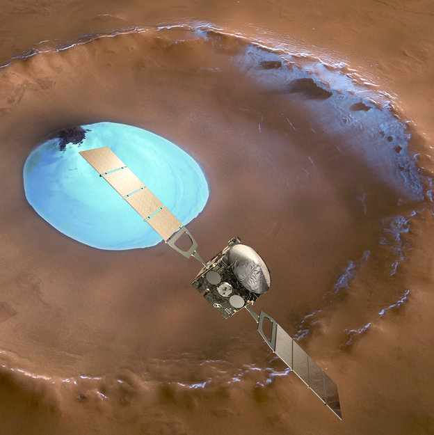
Mars Express over water-ice crater. ESA Celebrates 10 Years since the launch of Mars Express. This artists concept shows Mars Express set against a 35 km-wide crater in the Vastitas Borealis region of Mars at approximately 70.5°N / 103°E. The crater contains a permanent patch of water-ice that likely sits upon a dune field – some of the dunes are exposed towards the top left in this image. Copyright ESA/DLR/FU-Berlin-G.Neukum
This week marks the 10th anniversary since the launch of the European Space Agencies’ (ESA) Mars Express orbiter from the Baikonur Cosmodrome in Russia on June 2, 2003 and a decade of ground breaking science discoveries at the Red Planet.
2003 was a great year for Mars exploration as it also saw the dual liftoffs of NASA’s now legendary rovers Spirit & Opportunity from Cape Canaveral in Florida.
The immense quantity and quality of science data returned from Mars Express -simultaneously with Spirit and Opportunity – has completely transformed our understanding of the history and evolution of the Red Planet.
All three spacecraft have functioned far beyond their original design lifetime.
Earth’s exploration fleet of orbiters, landers and rovers have fed insights to each other that vastly multiplied the science output compared to working solo during thousands and thousands of bonus Sols at Mars.
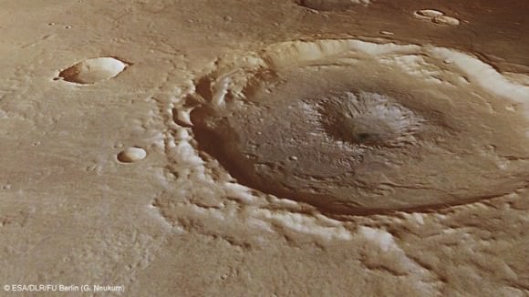
Inside a central pit crater. Perspective view of a 50 km diameter crater in Thaumasia Planum. The image was made by combining data from the High-Resolution Stereo Camera on ESA’s Mars Express with digital terrain models. The image was taken on 4 January 2013, during orbit 11467, and shows a close up view of the central ‘pit’ of this crater, which likely formed by a subsurface explosion as the heat from the impact event rapidly vapourised water or ice lying below the surface. Copyright ESA/DLR/FU-Berlin-G.Neukum
Mars Express derived its name from an innovative new way of working in planetary space science that sped up the development time and cut costs in the complex interactive relationships between the industrial partners, space agencies and scientists.
Indeed the lessons learned from building and operating Mars Express spawned a sister ship, Venus Express that also still operates in Venusian orbit.
Mars Express (MEX) achieved orbit in December 2003.
MEX began science operations in early 2004 with an array of seven instruments designed to study all aspects of the Red Planet, including its atmosphere and climate, and the mineralogy and geology of the surface and subsurface with high resolution cameras, spectrometers and radar.
The mission has been granted 5 mission extensions that will carry it to at least 2014.
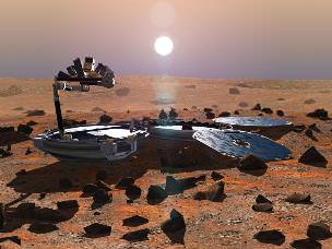
The mission has been wildly successful except for the piggybacked lander known as Beagle 2, which was British built.
Beagle 2The ambitious British lander was released from the mothership on December 19, 2003, six days before MEX braked into orbit around Mars. Unfortunately the Beagle 2 was never heard from again as it plummeted to the surface and likely crashed.
The high resolution camera (HRSC) has transmitted thousands of dramatic 3D images all over Mars ranging from immense volcanoes, steep-walled canyons, dry river valleys, ancient impact craters of all sizes and shapes and the ever-changing polar ice caps.
It carried the first ever radar sounder (MARSIS) to orbit another planet and has discovered vast caches of subsurface water ice.
MEX also played a significant role as a data relay satellite for transmissions during the landings of NASA’s Phoenix lander and Curiosity rover. It also occasionally relays measurements from Spirit & Opportunity to NASA.
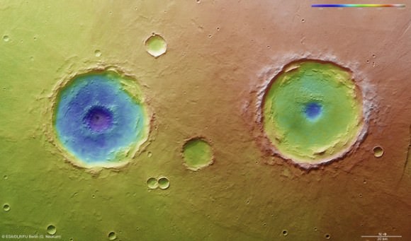
Arima twins topography. This colour-coded overhead view is based on an ESA Mars Express High-Resolution Stereo Camera digital terrain model of the Thaumasia Planum region on Mars at approximately 17°S / 296°E. The image was taken during orbit 11467 on 4 January 2013. The colour coding reveals the relative depth of the craters, in particular the depths of their central pits, with the left-hand crater penetrating deeper than the right (Arima crater). Copyright: ESA/DLR/FU-Berlin-G.Neukum
Here is a list of the Top 10 Discoveries from Mars Express from 2003 to 2013:
Mars Express mineralogy maps. This series of five maps shows near-global coverage of key minerals that help plot the history of Mars. The map of hydrated minerals indicates individual sites where a range of minerals that form only in the presence of water were detected. The maps of olivine and pyroxene tell the story of volcanism and the evolution of the planet’s interior. Ferric oxides, a mineral phase of iron, are present everywhere on the planet: within the bulk crust, lava outflows and the dust oxidised by chemical reactions with the martian atmosphere, causing the surface to ‘rust’ slowly over billions of years, giving Mars its distinctive red hue. Copyright: ESA/CNES/CNRS/IAS/Université Paris-Sud, Orsay; NASA/JPL/JHUAPL; Background images: NASA MOLA#1. First detection of hydrated minerals in the form of phyllosilicates and hydrated sulfates – evidence of long periods of flowing liquid water from the OMEGA visible and infrared spectrometer provided confirmation that Mars was once much wetter than it is today and may have been favorable for life to evolve.
#2. Possible detection of methane in the atmosphere from the Planetary Fourier Spectrometer (PFS) which could originate from biological or geological activity.
#3. Identification of recent glacial landforms via images from the High Resolution Stereo Camera (HRSC) are stem from viscous flow features composed of ice-rich material derived from adjacent highlands.
#4. Probing the polar regions. OMEGA and MARSIS determined that the south pole consists of a mixture frozen water ice and carbon dioxide. If all the polar ice melted the planet would be covered by an ocean 11 meters deep.
#5. Recent and episodic volcanism perhaps as recently as 2 million years ago. Mars has the largest volcanoes in the solar system . They are a major factor in the evolution of the martian surface, atmosphere and climate.
#6. Estimation of the current rate of atmospheric escape, helps researchers explain how Mars changed from a warm, wet place to the cold, dry place it is today.
#8. A new, meteoric layer in the martian ionosphere created by fast-moving cosmic dust which burns up as it hits the atmosphere.
#9. Unambiguous detection of carbon dioxide clouds. The freezing and vaporisation of CO2 is one of the main climatic cycles of Mars, and it controls the seasonal variations in surface air pressure.
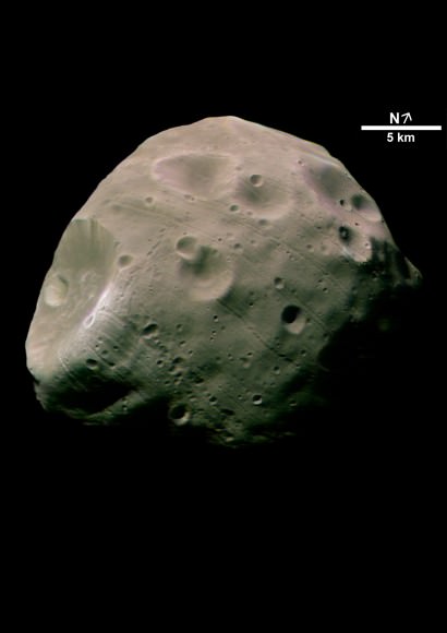
#10. Unprecedented probing of the Martian moon Phobos – which could be a target for future landers and human missions.
The Mars-facing side of Phobos. Credit: ESA/DLR/FU Berlin (G. Neukum)
And don’t forget to “Send Your Name to Mars” aboard NASA’s MAVEN orbiter- details here. Deadline: July 1, 2013
June 23: “Send your Name to Mars on MAVEN” and “CIBER Astro Sat, LADEE Lunar & Antares Rocket Launches from Virginia”; Rodeway Inn, Chincoteague, VA, 8 PM
New topography map of Antarctica by the British Antarctic Survey's Bedmap2 (NASA/GSFC)
Although it sits isolated at the “bottom of the world” Antarctica is one of the most influential continents on Earth, affecting weather, climate, and ocean current patterns over the entire planet. But Antarctica is also one of the most enigmatic landmasses too, incredibly remote, extremely harsh, and covered by a layer of ice over 2 km thick. And as Earth’s global temperature continues to climb steadily higher, the future of ice in Antarctica — a continent half again as large as the contiguous United States — is a big concern for scientists… but in order to know exactly how its ice will behave to changing conditions, they need to know what’s under it.
This is where the British Antarctic Survey — using data gathered by NASA’s ICESat and Operation IceBridge missions — comes in, giving us a better view of what lies beneath the southern continent’s frozen veil.
A new dataset called Bedmap2 gives a clearer picture of Antarctica from the ice surface down to the bedrock below. Bedmap2 is a significant improvement on the previous collection of Antarctic data — known as Bedmap — that was produced more than 10 years ago. The product was a result of work led by the British Antarctic Survey, where researchers compiled decades worth of geophysical measurements, such as surface elevation measurements from NASA’s Ice, Cloud and Land Elevation Satellite (ICESat) and ice thickness data collected by Operation IceBridge.
Bedmap2, like the original Bedmap, is a collection of three datasets—surface elevation, ice thickness and bedrock topography. Both Bedmap and Bedmap2 are laid out as grids covering the entire continent, but with a tighter grid spacing Bedmap2 includes many surface and sub-ice features too small to be seen in the previous dataset. Additionally, the extensive use of GPS data in more recent surveys improves the precision of the new dataset.
Improvements in resolution, coverage and precision will lead to more accurate calculations of ice volume and potential contribution to sea level rise.
Ice sheet researchers use computer models to simulate how ice sheets will respond to changes in ocean and air temperatures. An advantage of these simulations is that they allow testing of many different climate scenarios, but the models are limited by how accurate the data on ice volume and sub-ice terrain are.
Only the tips of many of Antarctica’s mountains are visible above thousands of feet of ice. (Oct. 2012 IceBridge photo. Credit: NASA / Christy Hansen)
“In order to accurately simulate the dynamic response of ice sheets to changing environmental conditions, such as temperature and snow accumulation, we need to know the shape and structure of the bedrock below the ice sheets in great detail,” said Michael Studinger, IceBridge project scientist at NASA Goddard.
Knowing what the bedrock looks like is important for ice sheet modeling because features in the bed control the ice’s shape and affect how it moves. Ice will flow faster on a downhill slope, while an uphill slope or bumpy terrain can slow an ice sheet down or even hold it in place temporarily. “The shape of the bed is the most important unknown, and affect how ice can flow,” said Nowicki. “You can influence how honey spreads on your plate, by simply varying how you hold your plate.” The vastly improved bedrock data included in Bedmap2 should provide the level of detail needed for models to be realistic.
Bedmap2 data of Antarctica’s bedrock. Verical elevation has been exaggerated by 17x. (NASA/GSFC)
“It will be an important resource for the next generation of ice sheet modelers, physical oceanographers and structural geologists,” said Peter Fretwell, BAS scientist and lead author.
The BAS’ work was published recently in the journal The Cryosphere. Read more on the original release by George Hale here.
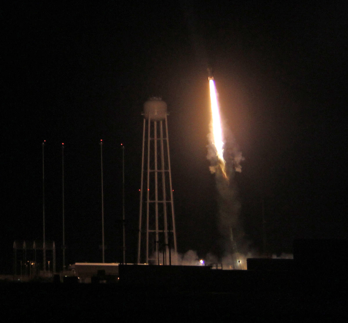
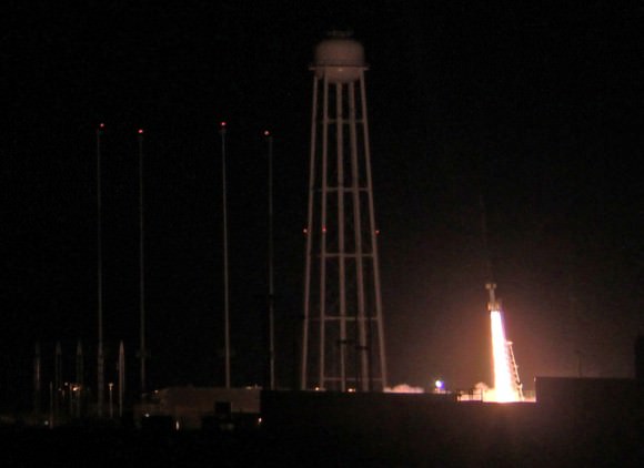
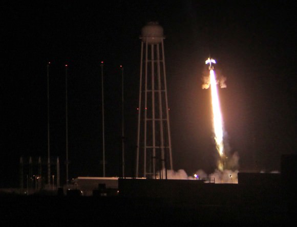
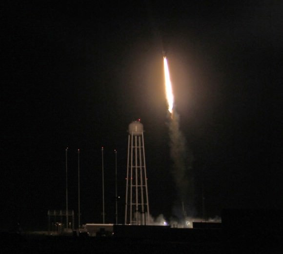
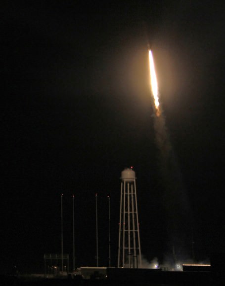
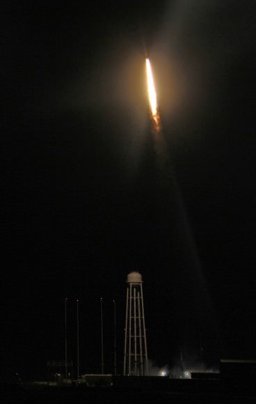
Night time blast off of 4 stage NASA Black Brant XII suborbital rocket at 11:05 p.m. EDT on June 5, 2013 from the NASA Wallops Flight Facility carrying the CIBER astronomy payload to study when the first stars and galaxies formed in the universe. The Black Brant soars above huge water tower at adjacent Antares rocket launch pad at NASA Wallops. Credit: Ken Kremer- kenkremer.com
Night time blast off of 4 stage NASA Black Brant XII suborbital rocket at 11:05 p.m. EDT on June 5, 2013 from the NASA Wallops Flight Facility carrying the CIBER astronomy payload to study when the first stars and galaxies formed in the universe. The Black Brant soars above huge water tower at adjacent Antares rocket launch pad at NASA Wallops. Credit: Ken Kremer- kenkremer.com Updated with more photos[/caption]
WALLOPS ISLAND, VA – The spectacular night time launch of a powerful Black Brant XII suborbital rocket from NASA’s launch range at the Wallops Flight Facility on Virginia’s Eastern Shore at 11:05 p.m. June 5 turned darkness into day as the rocket swiftly streaked skyward with the Cosmic Infrared Background ExpeRiment (CIBER) on a NASA mission to shine a bright beacon for science on star and galaxy formation in the early Universe.
A very loud explosive boom shook the local launch area at ignition that was also heard by local residents and tourists at distances over 10 miles away, gleeful spectators told me.
“The data looks good so far,” Jamie Bock, CIBER principal investigator from the California Institute of Technology, told Universe Today in an exclusive post-launch interview inside Mission Control at NASA Wallops. “I’m very happy.”
Ignition of NASA Black Brant XII suborbital rocket following night time launch at 11:05 p.m. EDT on June 5, 2013 from the NASA Wallops Flight Facility at the eastern Virginia shoreline. The launch pad sits in front of the Antares rocket Launch Complex 0A dominated by the huge water tower. The rocket carried the CIBER astronomy payload to an altitude of approximately 358 miles above the Atlantic Ocean to study when the first stars and galaxies formed in the universe and how brightly they burned their nuclear fuel. Credit: Ken Kremer- kenkremer.com
The four stage Black Brant XII is the most powerful sounding rocket in America’s arsenal for scientific research.
“I’m absolutely thrilled with this launch and this is very important for Wallops,” William Wrobel, Director of NASA Wallops Flight Facility, told me in an exclusive interview moments after liftoff.
Wallops is rapidly ramping up launch activities this year with two types of powerful new medium class rockets – Antares and Minotaur V- that can loft heavy payloads to the International Space Station (ISS) and to interplanetary space from the newly built pad 0A and the upgraded, adjacent launch pad 0B.
“We have launched over 16,000 sounding rockets.”
“Soon we will be launching our first spacecraft to the moon, NASA’s LADEE orbiter. And we just launched the Antares test flight on April 21.”
I was delighted to witness the magnificent launch from less than half a mile away with a big group of cheering Wallops employees and Wallops Center Director Wrobel. See my launch photos and time lapse shot herein.
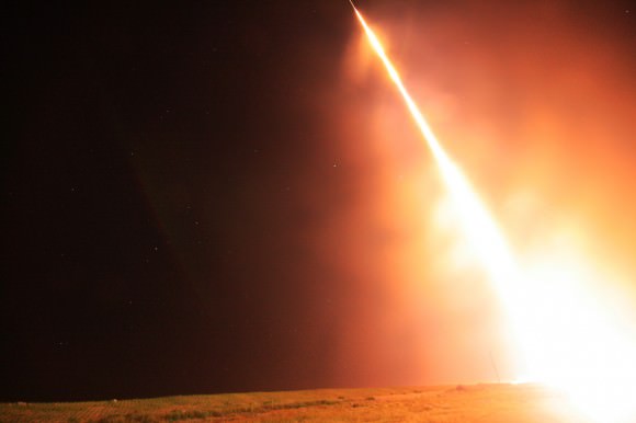
Everyone could hear piercing explosions as each stage of the Black Brant rocket ignited as it soared to the heavens to an altitude of some 358 miles above the Atlantic Ocean.
Seconds after liftoff we could see what looked like a rain of sparkling fireworks showing downward towards the launch pad. It was a fabulous shower of aluminum slag and spent ammonium perchlorate rocket fuel.
A powerful NASA Black Brant XII suborbital rocket streaks spectacularly into the night sky following its launch at 11:05 p.m. EDT on June 5, 2013 from the NASA Wallops Flight Facility at the eastern Virginia shoreline. The launch pad sits in front of the Antares rocket Launch Complex 0A dominated by the huge water tower. The rocket carried the Cosmic Infrared Background ExpeRiment (CIBER) to an altitude of approximately 358 miles above the Atlantic Ocean to study when the first stars and galaxies formed in the universe and how brightly they burned their nuclear fuel. Side firing thrusters have ignited to impart stabilizing spin as rocket ascends above launch rail. Credit: Ken Kremer- kenkremer.com
The awesome launch took place on a perfectly clear night drenched with brightly shining stars as the Atlantic Ocean waves relentlessly pounded the shore just a few hundred feet away.
The rocket zoomed past the prominent constellation Scorpius above the Atlantic Ocean.
In fact we were so close that we could hear the spent first stage as it was plummeting from the sky and smashed into the ocean, perhaps 10 miles away.
After completing its spectral collection to determine when did the first stars and galaxies form and how brightly did they shine burning their nuclear fuel, the CIBER payload splashed down in the Atlantic Ocean and was not recovered.
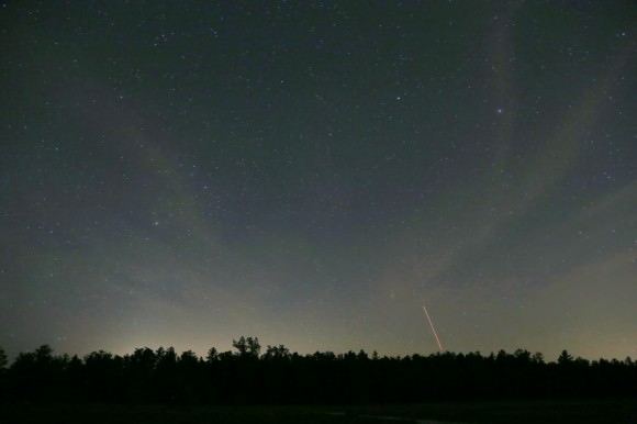
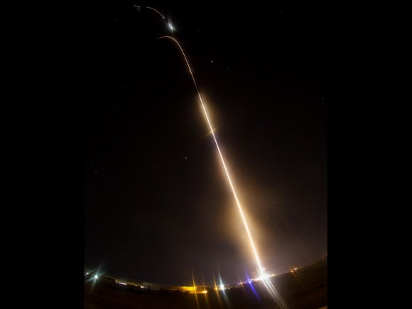
Time lapse view of night launch of NASA Black Brant XII suborbital rocket zooming past constellation Scorpius (left) at 11:05 p.m. EDT above Atlantic Ocean on June 5, 2013 from the NASA Wallops Flight Facility carrying the CIBER astronomy payload. Credit: Ken Kremer- kenkremer.comNight time launch of NASA Black Brant XII suborbital rocket at 11:05 p.m. EDT on June 5, 2013 from the NASA Wallops Flight Facility carrying the CIBER astronomy payload. Credit: Ken Kremer- kenkremer.com
NASA said the launch was seen from as far away as central New Jersey, southwestern Pennsylvania and northeastern North Carolina.
One of my astronomy friends Joe Stieber, did see the launch from about 135 miles away in central New Jersey and captured beautiful time lapse shots (see below).
Time lapse view of June 5 launch of Blank Brant XII sounding rocket from Wallops Island as seen from Carranza Field in Wharton State Forest, NJ (about 135 miles north from Wallops). Scorpius is above the trees at the far left. Credit: Joe Stieber- sjastro.com
Everything with the rocket and payload went exactly as planned.
“This was our fourth and last flight of the CIBER payload,” Bock told me. “We are still analyzing data from the last 2 flights.”
“CIBER first flew in 2009 atop smaller sounding rockets launched from White Sands Missile Range, N.M. and was recovered.”
“On this flight we wanted to send the experiment higher than ever before to collect more measurements for a longer period of time to help determine the brightness of the early Universe.”
CIBER is instrumented with 2 cameras and 2 spectrometers.
“The payload had to be cooled to 84 Kelvin with liquid nitrogen before launch in order for us to make the measurements,” Bock told me.
“The launch was delayed a day from June 4 because of difficulty both in cooling the payload to the required temperature and in keeping the temperature fluctuations to less than 100 microkelvins,” Bock explained
The CIBER experiment involves scientists and funding from the US and NASA, Japan and South Korea.
Bock is already thinking about the next logical steps with a space based science satellite.
Space.com has now featured an album of my CIBER launch photos – here
Night launch of NASA Black Brant XII suborbital rocket at 11:05 p.m. EDT on June 5, 2013 from NASA Wallops Flight Facility, VA carrying CIBER astronomy payload. Credit: Ken Kremer
And don’t forget to “Send Your Name to Mars” aboard NASA’s MAVEN orbiter- details here. Deadline: July 1, 2013
June 23: “Send your Name to Mars on MAVEN” and “CIBER Astro Sat, LADEE Lunar & Antares Rocket Launches from Virginia”; Rodeway Inn, Chincoteague, VA, 8 PM
Aerial view of NASA Wallops launch site on Virginia shore shows launch pads for both suborbital and orbital rockets. CIBER’s Black Brant XII rocket blasted off just behind the Pad 0A water tower. This photo was snapped from on top of Pad 0B that will soon launch NASA‘s LADEE orbiter to the Moon. Credit: Ken Kremer- kenkremer.comNASA’s CIBER experiment seeks clues to the formation of the first stars and galaxies. CIBER blasted off on June 5 from the NASA Wallops Flight Facility, Virginia. It will study the total sky brightness, to probe the component from first stars and galaxies using spectral signatures, and searches for the distinctive spatial pattern seen in this image, produced by large-scale structures from dark matter. This shows a numerical simulation of the density of matter when the universe was one billion years old. Galaxies formation follows the gravitational wells produced by dark matter, where hydrogen gas coalesces, and the first stars ignite. Credit: Volker Springel/Virgo Consortium.NASA Time lapse view shows multiple stages firing during night launch of NASA Black Brant XII suborbital rocket at 11:05 p.m. EDT above Atlantic Ocean on June 5, 2013 from the NASA Wallops Flight Facility carrying the CIBER astronomy payload. Credit: NASA/Jamie AdkinsNASA Black Brant XII suborbital rocket streaks skyward after blastoff at 11:05 p.m. EDT on June 5, 2013 from NASA Wallops Flight Facility, VA carrying CIBER astronomy payload. Credit: Ken Kremer
Will NASA's stellar education and outreach programs be cut?
The first Moon landing inspired a whole generation of scientists and engineers. And NASA, to its great credit, didn’t rest on those laurels: Outreach programs attached to the different NASA missions became a standard mode of operation. Some have reached legendary status. Without outreach, and the broad public support it engendered, the Hubble Space Telescope quite probably wouldn’t have had its faulty vision corrected.
And, not least thanks to the Internet, many NASA resources are available worldwide, and have a substantial impact on outreach efforts in other countries. (And in case you were wondering: yes, that’s the reason that I as a German am writing this blog post about NASA and, later on, about US policy. We profit from NASA resources – thanks! – and if NASA outreach loses, you lose, and we lose.)
One of the reasons science outreach by NASA and similar organizations is so powerful is the sheer fascination of black holes, distant galaxies, planets around distant stars, human space-travel, the big bang, or plucky little rovers exploring Mars. But there is another important factor, and that is the direct involvement of scientists and engineers who are immersed in, and passionate about, what they do. Quoting from a slightly different context:
“[The] ability to impart knowledge, it seems to me, has very little to do with technical method. […] It consists, first, of a natural talent for dealing with children, for getting into their minds, for putting things in a way that they can comprehend. And it consists, secondly, of a deep belief in the interest and importance of the thing taught, a concern about it amounting to a sort of passion.
A man who knows a subject thoroughly, a man so soaked in it that he eats it, sleeps it and dreams it—that man can always teach it with success, no matter how little he knows of technical pedagogy. That is because there is enthusiasm in him, and because enthusiasm is almost as contagious as fear of the barber’s itch. […] This passion, so unordered and yet so potent, explains the capacity for teaching that one frequently observes in scientific men of high attainments in their specialties […]”
We might not fear the barber’s itch quite as much as they did in the 1920s, when American journalist and essayist, H. L. Mencken, wrote those lines. But Mencken’s main message is as true now as it was back then. The best science outreach projects I’ve seen — and as managing scientist of a Center for Astronomy Education and Outreach I try to keep reasonably up to date — directly involve people whose enthusiasm for their subject is contagious — scientists communicating their own research, or outreach scientists and educators working closely with researchers.
That’s the reason why I’m worried about the future of NASA education and public outreach. There is, right now, a major effort by the Obama administration to restructure federal STEM education efforts (STEM being Science, Technology, Engineering, and Math). Apparently, the committee known as CoSTEM that is the driving force of this initiative didn’t do a very good job in engaging outreach practitioners in a dialogue about the changes, because the first thing many of those active in the field heard about the sweeping changes were ominous statements in the administration’s NASA Budget Proposal for Fiscal Year 2014, published on April 10 (PDF 34 MB).
NASA’s Leland Melvin talks with Tweet-up participants at the STS-133 launch in February, 2011. Credit: Nancy Atkinson.
The proposal is somewhat sketchy on the details, but what was there was worrying enough for a number stakeholders to speak up: Phil Plait, who used to be himself involved in mission-based outreach, has commented on the “bad news”, and Pamela Gay, whose group is responsible for CosmoQuest, among other projects, has weighed in (also here) — her group largely depends on the kind of NASA funding that could be eliminated in the restructuring. More recently, the American Astronomical Society has issued a Statement on Proposed Elimination of NASA Science Education & Public Outreach Programs.
On June 4, there was a hearing of the House Committee on Science, Space and Technology (the link has an archived webcast of the hearing, as well as some written statements). Judging by some of the answers at the hearing, the implementation of the restructuring hasn’t been fully worked out yet — but what information is out there is indeed somewhat worrying. It sounds like an efficiency-and-evaluation drive with little regard for the power of scientific passion.
The proposal calls for slashing NASA’s budget for education by almost a third. It promises that NASA’s “education efforts will be fundamentally restructured into a consolidated education program funded through the Office of Education, which will coordinate closely with the Department of Education, the National Science Foundation, and the Smithsonian Institution”. In particular, the consolidation concerns the outreach activities connected directly to the various missions: “mission-based K-12 education, public outreach, and engagement activities, traditionally funded within programmatic accounts, will be incorporated into the Administration’s new STEM education paradigm in order to reach an even wider range of students and educators”.
The Smithsonian Institution will take the lead on informal outreach and engagement. It’s not quite clear what that means, but they will get $25 million to do it. They have apparently promised to interact very closely with the mission agencies they would be “helping” in their role of “clearing house” for this kind of activity. Does that mean that they will become the main agency to develop outreach materials — will NASA missions have to provide them with information about their science, and receive custom-made (or not) outreach kits in return? Or will they have more of an advisory capacity — will they somehow assist NASA outreach units to develop material, and help with the distribution? Your guess is as good as mine.
A number of committee members expressed their concern in this direction, as well, asking about the role of their local institutions such as science museums, STEM initiatives and the like in the new scheme. The answers weren’t very encouraging. There was talk of strong partnerships being developed, but apparently the desire to build partnerships didn’t go as deep as actually trying to communicate with those stakeholders beforehand.
Committee member Elizabeth Esty (D-CT) actually raised the matter that is my main concern in this blog post: she talked about the importance of engaging science practitioners and engineers directly, having them interact with school students; she also talked about the excitement for science that NASA has been so good at generating.
Again, the answers weren’t very encouraging (this is around 1h 40m into the hearing). The NSF representative (Joan Ferrini-Mundy) talked about the increased reach the Department of Education could provide, and the NASA representative (Leland D. Melvin) went down the same road, praising how the Department of Education was helping NASA to make their hands-on activities available in more states than ever before. Neither appeared to have understood that the question was about something altogether different than mere efficiency in the distribution of educational materials.
Participation in classrooms from NASA personel might be a thing of the past. Here, Kristyn Damadeo from a project called SAGE III on ISS project reads to students during Earth Science Week. Credit: NASA
And while the inspiration by astronauts interacting with school students, or the excitement generated by the direct contact with researchers, was at least mentioned during the hearing, the role of outreach scientists — as mediators with a background in science and a job in science communication — was completely absent from the hearing and, incidentally, from the CoSTEM documents.
To me, all of this appears to add up to a move into precisely the wrong direction. For powerful science outreach, you want to channel the passion of the researchers/engineers through the educators and outreach scientists; to that end, you want the connections between those groups to be as close as possible.
A small-to-medium-size outreach team working directly with one or a few missions fits the bill. Replace local teams with large, centralized entities responsible for a much wider portfolio of activities and missions, and you are bound to lose those immediate connections. So, by all means, consolidate where consolidation makes sense — centralized distribution, centralized services such as graphics or video editing, web services, consultation with experienced educators, a school partnership network coordinated by the Department of Education, or what have you — but mission-based outreach scientists and educators do not fall into that category.
If the “new paradigm” widens the gap between the scientists and engineers on the one hand and the educators and outreach scientists on the other, that’s bad news for NASA outreach.
The good news is that the committee demonstrated considerable interest in the matter — and a healthy dose of skepticism. Several members talked about the questions they had received from constituents and stakeholders about the reform. Some remarked on having seldomly seen the meeting room as crowded.
After June 4, committee members apparently still have two weeks to submit their written questions to the witnesses: to presidential science advisor John Holdren, NSF assistant director in the Directorate for Education and Human Resources, Joan Ferrini-Mundy, and Leland D. Melvin, who’s the Associate Administrator for Education at NASA. And a number of committee members (watch the webcast!) seemed quite aware that there are open questions, reasons for skepticism, and room for discussion.
So there’s your chance to do something for NASA (and other agencies’) outreach:Here is a list of the committee members. Express your concern. Ask them what the changes will mean for existing programs (here is a complete list of the programs concerned). Remind them that this is not only about abstract numbers, but about people. The way things are organized right now, there are many individual outreach scientists, researchers, engineers, educators who’ve spent years gaining experience with, and coming up with innovative ideas for, communicating their science. That’s a considerable resource right there — so what will happen with those people and their expertise under the new scheme?
If you have a favourite mission, outreach program or activity (Chandra, CosmoQuest, Hubble, …), ask the committee members how it will be affected by the consolidation. What will happen to the people who made the program/activity what it is? And do so soon, so the committee members can pass their questions and concerns on to the people responsible for this restructuring. This restructuring seems to be something of a turning point for federally funded science outreach in the US (and, yes, for all of us in the rest of the world who profit from that outreach as well). If you or your children have profited from any of those outreach activities, here’s your chance to give something back.
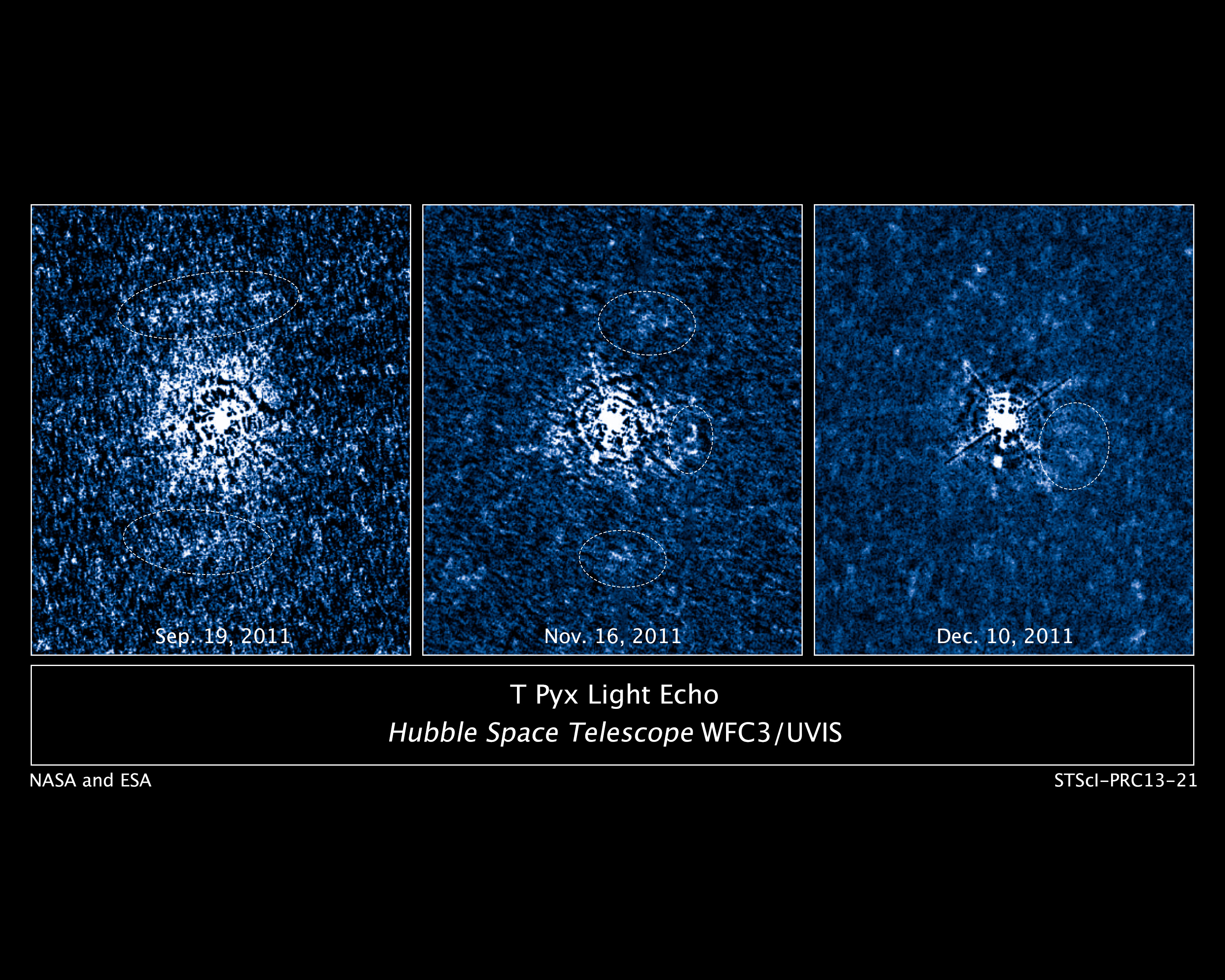
A sequence of images showing the light echo (circled) enshrouding T Pyxidis months after the April 2011 outburst. (Credit: NASA/ESA/A. Crotts/J. Sokoloski, H. Uthas & S. Lawrence).
Some of the most violent events in our Universe were the topic of discussion this morning at the 222nd meeting of the American Astronomical Society in Indianapolis, Indiana as researchers revealed recent observations of light echoes seen as the result of stellar explosions.
A light echo occurs when we see dust and ejected material illuminated by a brilliant nova. A similar phenomenon results in what is termed as a reflection nebula. A star is said to go nova when a white dwarf star siphons off material from a companion star. This accumulated hydrogen builds up under terrific pressure, sparking a brief outburst of nuclear fusion.
A very special and rare case is a class of cataclysmic variables known as recurrent novae. Less than dozen of these types of stars are known of in our galaxy, and the most famous and bizarre case is that of T Pyxidis.
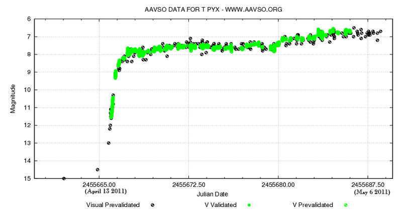
Located in the southern constellation of Pyxis, T Pyxidis generally hovers around +15th magnitude, a faint target even in a large backyard telescope. It has been prone, however, to great outbursts approaching naked eye brightness roughly every 20 years to magnitude +6.4. That’s a change in brightness almost 4,000-fold.
But the mystery has only deepened surrounding this star. Eight outbursts were monitored by astronomers from 1890 to 1966, and then… nothing. For decades, T Pyxidis was silent. Speculation shifted from when T Pyxidis would pop to why this star was suddenly undergoing a lengthy phase of silence.
Could models for recurrent novae be in need of an overhaul?
T Pyxidis finally answered astronomers’ questions in 2011, undergoing its first outburst in 45 years. And this time, they had the Hubble Space Telescope on hand to witness the event.
Light curve of the 2011 eruption of T Pyxidis. (Credit: AAVSO).
In fact, Hubble had just been refurbished during the final visit of the space shuttle Atlantis to the orbiting observatory in 2009 on STS-125 with the installation of its Wide Field Camera 3, which was used to monitor the outburst of T Pyxidis.
The Hubble observation of the light echo provided some surprises for astronomers as well.
“We fully expected this to be a spherical shell,” Said Columbia University’s Arlin Crotts, referring to the ejecta in the vicinity of the star. “This observation shows it is a disk, and it is populated with fast-moving ejecta from previous outbursts.”
Indeed, this discovery raises some exciting possibilities, such as providing researchers with the ability to map the anatomy of previous outbursts from the star as the light echo evolves and illuminates the 3-D interior of the disk like a Chinese lantern. The disk is inclined about 30 degrees to our line of sight, and researchers suggest that the companion star may play a role in the molding of its structure from a sphere into a disk. The disk of material surrounding T Pyxidis is huge, about 1 light year across. This results in an apparent ring diameter of 6 arc seconds (about 1/8th the apparent size of Jupiter at opposition) as seen from our Earthly vantage point.
Paradoxically, light echoes can appear to move at superluminal speeds. This illusion is a result of the geometry of the path that the light takes to reach the observer, crossing similar distances but arriving at different times.
And speaking of distance, measurement of the light echoes has given astronomers another surprise. T Pyxidis is located about 15,500 light years distant, at the higher 10% end of the previous 6,500-16,000 light year estimated range. This means that T Pyxidis is an intrinsically bright object, and its outbursts are even more energetic than thought.
Light echoes have been studied surrounding other novae, but this has been the first time that scientists have been able to map them extensively in 3 dimensions.
An artist’s conception of the disk of material surrounding T Pyxidis. (Credit: ESA/NASA & A. Feild STScl/AURA).
“We’ve all seen how light from fireworks shells during the grand finale will light up the smoke and soot from the shells earlier in the show,” said team member Stephen Lawrence of Hofstra University. “In an analogous way, we’re using light from T Pyx’s latest outburst and its propagation at the speed of light to dissect its fireworks displays from decades past.”
Researchers also told Universe Today of the role which amateur astronomers have played in monitoring these outbursts. Only so much “scope time” exists, very little of which can be allocated exclusively to the study of light echoes. Amateurs and members of the American Association of Variable Star Observers (AAVSO) are often the first to alert the pros that an outburst is underway. A famous example of this occurred in 2010, when Florida-based backyard observer Barbara Harris was the first to spot an outburst from recurrent novae U Scorpii.
And although T Pyxidis may now be dormant for the next few decades, there are several other recurrent novae worth continued scrutiny:
Name
Max brightness
Right Ascension
Declination
Last Eruption
Period(years)
U Scorpii
+7.5
16H 22’ 31”
-17° 52’ 43”
2010
10
T Pyxidis
+6.4
9H 04’ 42”
-32° 22’ 48”
2011
20
RS Ophiuchi
+4.8
17H 50’ 13”
-6° 42’ 28”
2006
10-20
T Coronae Borealis
+2.5
15H 59’ 30”
25° 55’ 13”
1946
80?
WZ Sagittae
+7.0
20H 07’ 37”
+17° 42’ 15”
2001
30
Clearly, recurrent novae have a tale to tell us of the role they play in the cosmos. Congrats to Lawrence and team on the discovery… keep an eye out from future fireworks from this rare class of star!
“Being gay doesn’t necessarily define you, it’s just one factor of who you are.”
– NASA Johnson Space Center Deputy Chief of Staff
For over 50 years NASA has inspired people of all ages around the world to set their sights above the sky, to believe in the power of innovation and to not only hope for a better future, but to make it happen. Now, in celebration of LGBT Equality Month, team members from NASA’s Johnson Space Center (and a certain former Starfleet helmsman) tell young people struggling with their identity, “it gets better.”
It’s yet another example of NASA’s commitment to inspiration — regardless of your orientation.
The NASA JSC It Gets Better video is a video project created by the “Out & Allied @ JSC Employee Resource Group” of NASA’s Johnson Space Center. It was created as an outreach tool primarily directed at high school and college-aged lesbian, gay, bisexual, transgender, queer and questioning (LGBTQ) individuals who are victims of bullying and/or have been affected by bullying. This video sends the message to current and future NASA employees that it is OK to be LGBTQ, and that NASA JSC management supports and encourages an inclusive, diverse workforce in our workplace.
Established in 1961 as the Manned Spaceflight Center, NASA’s Johnson Space Center has served as a hub of human spaceflight activity for more than half a century. As the nucleus of the nation’s astronaut corps and home to International Space Station mission operations and a host of future space developments, the center plays a pivotal role in surpassing the physical boundaries of Earth and enhancing technological and scientific knowledge to benefit all of humankind.
NASA’s CIBER experiment seeks clues to the formation of the first stars and galaxies. It will study the total sky brightness, to probe the component from first stars and galaxies using spectral signatures, and searches for the distinctive spatial pattern seen in this image, produced by large-scale structures from dark matter. This shows a numerical simulation of the density of matter when the universe was one billion years old. Galaxies formation follows the gravitational wells produced by dark matter, where hydrogen gas coalesces, and the first stars ignite. Credit: Volker Springel/Virgo Consortium.
When did the first stars and galaxies form in the universe and how brightly did they burn?
Scientists are looking for tell-tale signs of galaxy formation with an experimental payload called CIBER.
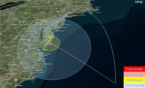
NASA will briefly turn night into day near midnight along the mid-Atlantic coastline on June 4 – seeking answers to illuminate researchers theories about the beginnings of our Universe with the launch of the Cosmic Infrared Background ExpeRiment (CIBER) from NASA’s launch range at the Wallops Flight Facility along Virginia’s eastern shoreline. See viewing map below.
CIBER will blast off atop a powerful four stage Black Brant XII suborbital rocket at 11 PM EDT Tuesday night, June 4. The launch window extends until 11:59 PM EDT.
Currently the weather forecast is excellent.
The public is invited to observe the launch from an excellent viewing site at the NASA Visitor Center at Wallops which will open at 9:30 PM on launch day.
The night launch will be visible to spectators along a long swath of the US East coast from New Jersey to North Carolina; if the skies are clear as CIBER ascends to space to an altitude of over 350 miles and arcs over on a southeasterly trajectory.
Backup launch days are available from June 5 through 10.
Launch visibility map for the CIBER payload launch from NASA Wallops, Va, on June 4, 2013 at 11 PM EDT. Credit: NASA
“The objectives of the experiment are of fundamental importance for astrophysics: to probe the process of first galaxy formation. The measurement is extremely difficult technically,” said Jamie Bock, CIBER principal investigator from the California Institute of Technology
Over the past several decades more than 20,000 sounding rockets have blasted off from an array of launch pads at Wallops, which is NASA’s lead center for suborbital science.
The Black Brant XII sounding rocket is over 70 feet tall.
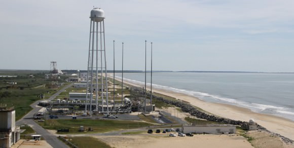
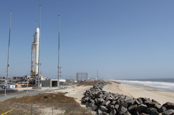
The launch pad sits adjacent to the newly constructed Pad 0A of the Virginia Spaceflight Authority from which the Orbital Sciences Antares rocket blasted off on its maiden flight on April 21, 2013.
“The first massive stars to form in the universe produced copious ultraviolet light that ionized gas from neutral hydrogen. CIBER observes in the near infrared, as the expansion of the universe stretched the original short ultraviolet wavelengths to long near-infrared wavelengths today.”
“CIBER investigates two telltale signatures of first star formation — the total brightness of the sky after subtracting all foregrounds, and a distinctive pattern of spatial variations,” according to Bock.
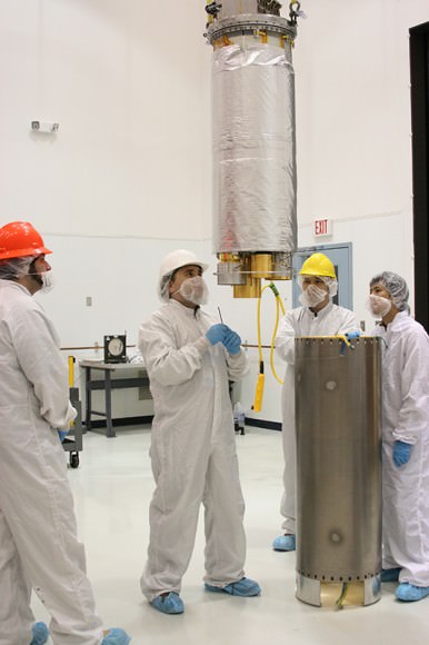
Preparing the CIBER instrument for flight. The optics and detectors are cooled by liquid nitrogen to -19C (77 K, -312F) during the flight to eliminate infrared emission from the instrument and to achieve the best detector sensitivity. Photo: NASA/Berit Bland
This will be the fourth launch of CIBER since 2009 but the first from Wallops. The three prior launches were all from the White Sands Missile Range, N.M. and in each case the payload was recovered and refurbished for reflight.
However the June 4 launch will also be the last hurrah for CIBER.
The scientists are using a more powerful Black Brant rocket to loft the payload far higher than ever before so that it can make measurements for more than twice as long as ever before.
The consequence of flying higher is that CIBER will splashdown in the Atlantic Ocean, about 400 miles off the Virgina shore and will not be recovered.
You can watch the launch live on NASA Ustream beginning at 10 p.m. on launch day at: http://www.ustream.com/channel/nasa-wallops
I will be onsite at Wallops for Universe Today.
And don’t forget to “Send Your Name to Mars” aboard NASA’s MAVEN orbiter- details here. Deadline: July 1, 2013
…………….
Learn more about Conjunctions, Mars, Curiosity, Opportunity, MAVEN, LADEE and NASA missions at Ken’s upcoming lecture presentations
June 4: “Send your Name to Mars on MAVEN” and “CIBER Astro Sat, LADEE Lunar & Antares Rocket Launches from Virginia”; Rodeway Inn, Chincoteague, VA, 8:30 PM
NASA’s CIBER payload will launch from a suborbital launch pad located directly behind this Antares rocket erected at Pad 0A at the NASA Wallops Flight Facility along the Eastern shore of Virginia. Only a few hundred feet of beach sand and a miniscule sea wall separate the Wallops Island pads from the Atlantic Ocean waves and Mother Nature.
Credit: Ken Kremer (kenkremer.com)
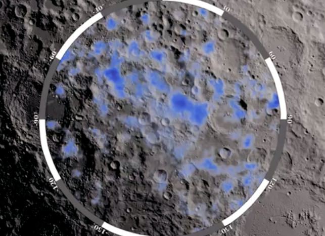
The blue areas show locations on the Moon's south pole where water ice is likely to exist (NASA/GSFC)
The Moon might seem like a poor place to hunt for water, but in fact there’s a decent amount of the stuff dispersed throughout the lunar soil — and even more of it existing as ice deposits in the dark recesses of polar craters. While the LCROSS mission crashed a rocket stage into one of these craters in October 2009 and confirmed evidence of water in the resulting plume of debris, there haven’t been any definitive maps made of water deposits across a large area on the Moon — until now.
Over the course of several years, NASA’s Lunar Reconnaissance Orbiter scanned the Moon’s south pole using its Lunar Exploration Neutron Detector (LEND) to measure how much hydrogen is trapped within the lunar soil. Areas exhibiting suppressed neutron activity — shown above in blue — indicate where hydrogen atoms are concentrated most, strongly suggesting the presence of water molecules… aka H2O.
The incredibly-sensitive LEND instrument measures the flux of neutrons from the Moon, which are produced by the continuous cosmic ray bombardment of the lunar surface. Even a fraction of hydrogen as small as 100 ppm can make a measurable change in neutron distribution from the surface of worlds with negligible atmospheres, and the hydrogen content can be related to the presence of water.
No other neutron instrument with LEND’s imaging capability has ever been flown in space.
Watch the video below for more details as to how LRO and LEND obtained these results:
“While previous lunar missions have observed indications of hydrogen at the Moon’s south pole, the LEND measurements for the first time pinpoint where hydrogen, and thus water, is likely to exist.”
What’s so important about finding water on the Moon? Well besides helping answer the question of where water on Earth and within the inner Solar System originated, it could also be used by future lunar exploration missions to produce fuel for rockets, drinking water, and breathable air. Read more here.
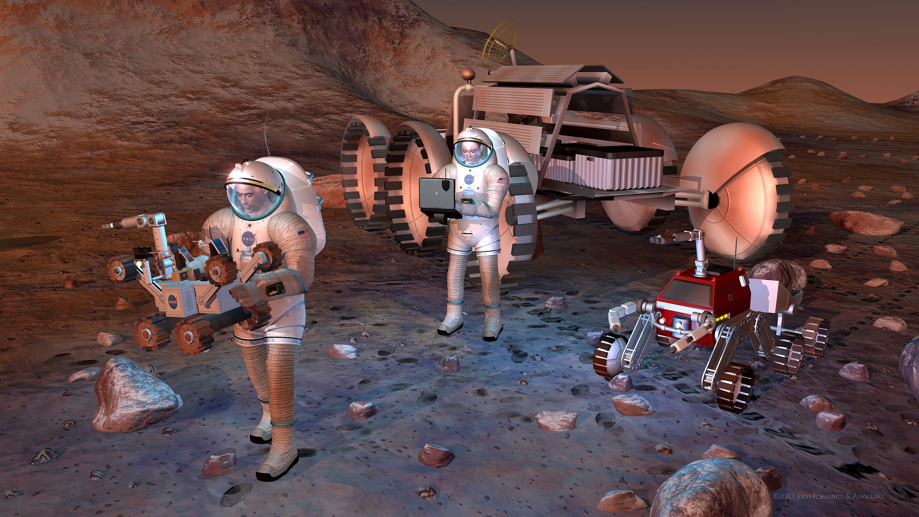
NASA astronauts exploring Mars on future missions starting perhaps in the 2030’s will require protection from long term exposure to the cancer causing space radiation environment. Credit: NASA.
New measurements of the energetic space radiation environment present in interplanetary space taken by NASA’s Curiosity rover confirm what has long been suspected – that lengthy years long voyages by astronauts to deep space destinations like Mars will expose the crews to high levels of radiation that – left unchecked – would be harmful to their health and increase their chances of developing fatal cancers.
Although the data confirm what scientists had suspected, it’s equally important to state that the space radiation data are not ‘show stoppers” for human deep space voyages to the Red Planet and other destinations because there are a multitude of counter measures- like increased shielding and more powerful propulsion – that NASA and the world’s space agencies can and must implement to reduce and mitigate the dangerous health effects of radiation on human travelers.
The new radiation data was released at a NASA media briefing on May 30 and published in the journal Science on May 31.
Indeed the new measurements collected by Curiosity’s Radiation Assessment Detector (RAD) instrument during her 253-day, 560-million- kilometer journey enroute to the Red Planet in 2011 and 2012 will provide important insights to allow NASA to start designing systems for safely conducting future human missions to Mars.
“NASA wants to send astronauts to Mars in the 2030’s,” Chris Moore, NASA’s deputy director of Advanced Exploration Systems NASA HQ, said to reporters at the media briefing.
“The Human Spaceflight and Planetary Science Divisions at NASA are working together to get the data needed for human astronauts. RAD is perfect to collect the data for that,” said Moore.
The RAD data indicate that astronauts would be exposed to radiation levels that would exceed the career limit levels set by NASA during a more than year long voyage to Mars and back using current propulsion systems, said Eddie Semones, spaceflight radiation health officer at the Johnson Space Center.
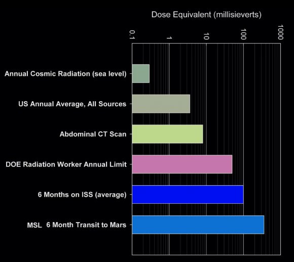
This graph compares the radiation dose equivalent for several types of experiences, including a calculation for a trip from Earth to Mars based on measurements made by the Radiation Assessment Detector (RAD) instrument shielded inside NASA’s Mars Science Laboratory spacecraft during the flight from Earth to Mars in 2011 and 2012. The data show that during a typical 6 month cruise to Mars the astronaut crews would be exposed to more than 3 times the typical 6 month exposure of astronauts aboard the ISS. The scale is logarithmic; each labeled value is 10 times greater than the next lowest one. The “dose equivalent” units are millisieverts. Credit: NASA/JPL-Caltech/SwRI
NASA’s Humans to Mars planning follows initiatives outlined by President Obama.
“As this nation strives to reach an asteroid and Mars in our lifetimes, we’re working to solve every puzzle nature poses to keep astronauts safe so they can explore the unknown and return home,” said William Gerstenmaier, NASA’s associate administrator for human exploration and operations in Washington, in a statement.
The International Space Station already in low Earth orbit and the Orion crew capsule under development will serve as very useful platforms to conduct real life experiments on resolving the health risks posed by long term exposure to space radiation.
“We learn more about the human body’s ability to adapt to space every day aboard the International Space Station, said Gerstenmaier. “As we build the Orion spacecraft and Space Launch System rocket to carry and shelter us in deep space, we’ll continue to make the advances we need in life sciences to reduce risks for our explorers. Curiosity’s RAD instrument is giving us critical data we need so that we humans, like the rover, can dare mighty things to reach the Red Planet.”
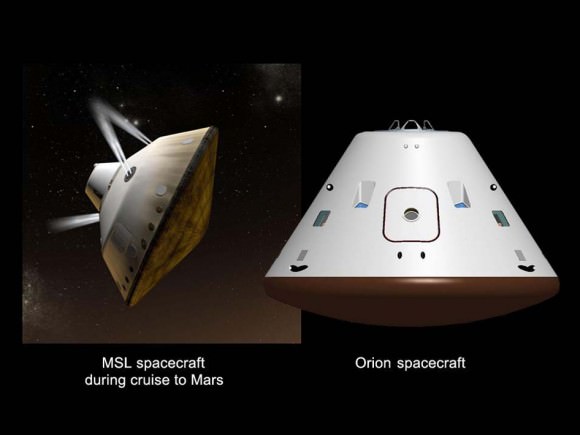
RAD was the first instrument to collect radiation measurements during the cruise phase to the Red Planet. It is mounted on the top deck of the Curiosity rover.
“Although RAD’s objective is to characterize the radiation environment on the surface of Mars, it’s also good for the cruise phase,” Don Hassler, RAD Principal Investigator at the Southwest Research Institute (SWRI) told reporters.
“Since Orion and MSL are similar sized RAD is ideal for collecting the data.”
Mars Cruise Vehicles. This graphic shows a comparison of NASA’s Mars Science Laboratory (MSL) cruise capsule and NASA’s Orion spacecraft, which is being built now at NASA’s Johnson Space Center and will one day send astronauts to Mars. The rover Curiosity is tucked inside of the Mars Science Laboratory cruise vehicle like human beings would be tucked inside Orion. MSL are Orion are similar in size. Credit: NASA/JPL-Caltech/JSC
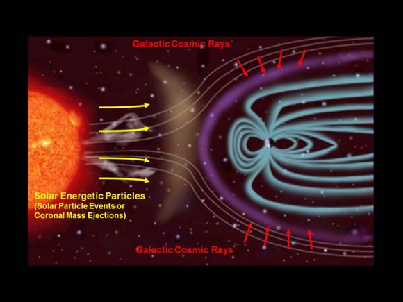
Hassler explained that RAD measures two types of radiation that pose health risks to astronauts. First, the steady stream of low dose galactic cosmic rays (GCRs), and second the short-term and unpredictable exposures to solar energetic particles (SEPs) arising from solar flares and coronal mass ejections (CME’s).
Radiation exposure is known to increase a person’s risk of suffering fatal cancer.
Exposure is measured in units of Sievert (Sv) or milliSievert (one one-thousandth Sv). Being exposed to a dose of 1 Sievert (Sv) over time results in a five percent increased risk of developing cancer.
NASA’s current regulations limit the potential for increased cancer risk to 3 percent for astronauts currently working on the ISS in low-Earth orbit.
RAD determined that the Curiosity rover was exposed to an average of 1.8 milliSieverts per day during the 8.5 month cruise to Mars, due mostly to Galactic Cosmic Rays, said Cary Zeitlin, SWRI Principal Scientist for MSL,at the briefing. “Solar particles only accounted for about 3 to 5 percent of that.”
During a typical 6 month cruise to Mars the astronaut crews would be exposed to 330 millisieverts. That is more than 3 times the typical 6 month exposure of astronauts aboard the ISS which amounts to about 100 millisieverts. See graphic above.
“The 360 day interplanetary round trip exposure would be 660 millisieverts based on chemical propulsion methods,” Zeitlin told Universe Today. “A 500 day mission would increase that to 900 millisieverts.”
By comparison, the average annual exposure for a typical person in the US from all radiation sources is less than 10 millisieverts.
The Earth’s magnetic field provides partial radiation shielding for the ISS astronauts living in low-Earth orbit.
“In terms of accumulated dose, it’s like getting a whole-body CT scan once every five or six days,” says Zeitlin.
And that round trip dose of 660 millisieverts doesn’t even include the astronauts surface stay on Mars – which would significantly raise the total exposure count. But luckily for the crew the surface radiation is less.
“The radiation environment on the surface of Mars is about half that in deep space since its modified by the atmosphere,” Hassler told Universe Today. “We will publish the surface data in a few months.”
NASA will need to decide whether to reassess the acceptable career limits for astronauts exposure to radiation from galactic cosmic rays and solar particle events during long duration deep space journeys.
Panoramic view of Yellowknife Bay basin back dropped by Mount Sharp shows the location of the first two drill sites – John Klein & Cumberland – targeted by NASA’s Curiosity Mars rover and the RAD radiation detector which took the first deep space measurements of harmful space radiation during the cruise phase to Mars in 2011 and 2012 . Curiosity accomplished historic 1st drilling into Martian rock at John Klein outcrop on Feb 8, 2013 (Sol 182) near where the robotic arm is touching the surface. This week the rover scooted about 9 feet to the right to Cumberland (right of center) for 2nd drill campaign on May 19, 2013 (Sol 279). Credit: NASA/JPL-Caltech/Ken Kremer – kenkremer.com/Marco Di Lorenzo
And don’t forget to “Send Your Name to Mars” aboard NASA’s MAVEN orbiter- details here. Deadline: July 1, 2013
…………….
Learn more about Conjunctions, Mars, Curiosity, Opportunity, MAVEN, LADEE and NASA missions at Ken’s upcoming lecture presentations
June 4: “Send your Name to Mars on MAVEN” and “CIBER Astro Sat, LADEE Lunar & Antares Rocket Launches from Virginia”; Rodeway Inn, Chincoteague, VA, 8:30 PM
Sources of Ionizing Radiation in Interplanetary Space. The Radiation Assessment Detector (RAD) on NASA’s Curiosity Mars rover monitors high-energy atomic and subatomic particles coming from the sun, distant supernovae and other sources. The two types of radiation are known as Galactic Cosmic Rays and Solar Energetic Particles. RAD measured the flux of this energetic-particle radiation while shielded inside the Mars Science Laboratory spacecraft on the flight delivering Curiosity from Earth to Mars, and continues to monitor the flux on the surface of Mars. Credit: NASA/JPL-Caltech/SwRI
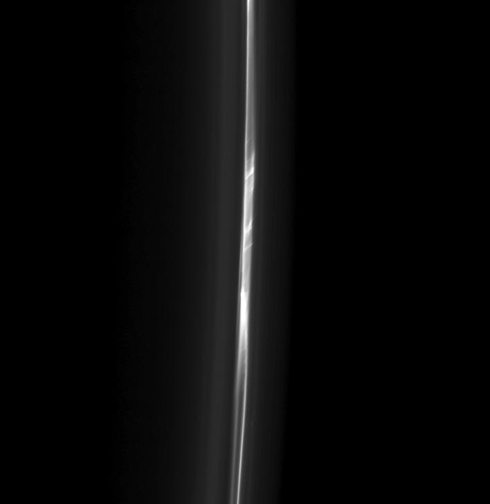
A ladder-like structure in Saturn's F ring seen by Cassini on Feb. 13, 2013 (NASA/JPL-Caltech/SSI)
Saturn’s F ring is certainly a curious structure. Orbiting the giant planet 82,000 kilometers above its equatorial cloud tops, the F ring is a ropy, twisted belt of bright ice particles anywhere from 30-500 km wide. It can appear as a solid band or a series of braided cords surrounded by a misty haze, and often exhibits clumps and streamers created by the gravitational influence of embedded moonlets or passing shepherd moons.
In the picture above, acquired by the Cassini spacecraft on Feb. 13, 2013 and released on May 27, we see a section of the F ring separated into long ropes and spanned by connecting bands of bright material — the “ladder” structure suggested in the title.
Scientists believe that interactions between the F ring and the moons Prometheus and Pandora cause the dynamic structure of the F ring. (Watch an animation of the F ring and shepherd moons here.)
Made of particles of water ice finer than cigarette smoke, the F ring orbits Saturn beyond the outer edge of the A ring across the expanse of the 2,600-km-wide Roche Division. In these images, Saturn and the main ring systems are off frame to the left.
Detail of ladder structure in the F ring
This view looks toward the unilluminated side of the rings from about 32 degrees below the ringplane. The image was taken in visible light with the Cassini spacecraft’s narrow-angle camera (NAC).
The view was obtained at a distance of approximately 426,000 miles (686,000 kilometers) from Saturn and at a phase angle of 162 degrees. Image scale is 2 miles (4 kilometers) per pixel.