IRIS will take a closer look at the lower parts of the sun's atmosphere, which is producing the spectacular flare shown in this image. Credit: NASA&JAXA/Hinode
How does the sun’s energy flow? Despite the fact that we live relatively close (93 million miles, or eight light-minutes) to this star, and that we have several spacecraft peering at it, we still know little about how energy transfers through the solar atmosphere.
NASA’s next solar mission will launch Wednesday, June 26 (if all goes to plan) to try to learn a little bit more. It’s called the Interface Region Imaging Spectrograph (IRIS), and it will zero in on a spot in the sun’s lower atmosphere known as the “interface region.” The zone only has a thickness of 3,000 to 6,000 miles and is seen as a key transfer point to the sun’s incredibly hot corona (that you can see during total solar eclipses.)
“IRIS will extend our observations of the sun to a region that has historically been difficult to study,” stated Joe Davila, IRIS project scientist at NASA’s Goddard Space Flight Center. “Understanding the interface region better improves our understanding of the whole corona and, in turn, how it affects the solar system.”
Figuring out more about the interface region, NASA stated, will teach us a lot more about the “space weather” that affects Earth.
Some of the energy in the interface region leaks out and powers the solar wind, which is a sort of rain of particles that leave the star. Some of them hit the Earth’s magnetic field and can produce auroras. Most of the sun’s ultraviolet radiation also flows from the interface region.
IRIS’ images will be able to zero in on about 1 percent of the sun in a single go, with resolution of features of as small as 150 miles. The 400-pound satellite will orbit Earth in an orbit perpetually keeping it above the sunrise line, a spot that lets the satellite look at the sun continuously for eight months without the sun being obscured by Earth.
It’ll also form part of a larger network of sun-staring satellites.
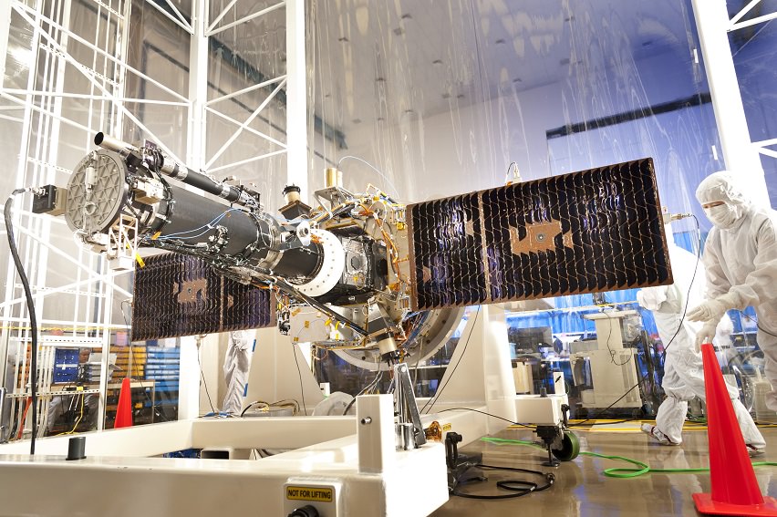
Technicians work on NASA’s Interface Region Imaging Spectrograph (IRIS) in a “clean room”, a specially designed facility intended to minimize contaminants on spacecraft before launch. Credit: Lockheed Martin
NASA highlighted its Solar Dynamics Observatory and a joint mission it has with Japan, called Hinode, which both take images of the sun in high-definition. These other two observatories, however, look at different solar layers (specifically, the surface and the outer atmosphere).
With IRIS joining the fleet and looking at the interface region, it will provide a more complete picture.
“Relating observations from IRIS to other solar observatories will open the door for crucial research into basic, unanswered questions about the corona,” stated Davila.
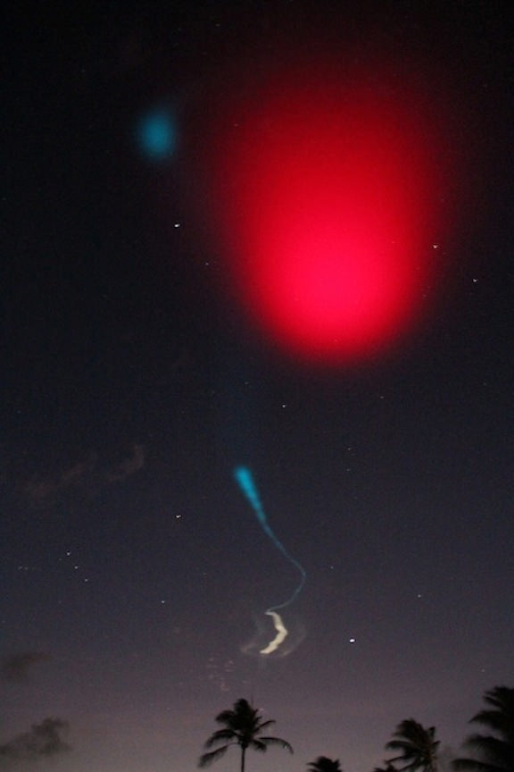
On June 24, 2013 a pair of daytime sounding rockets will launch from NASA Wallops Flight Facility (WFF) and deploy a chemical trail like the one deployed here from a sounding rocket at night. The chemical trail will help researchers track wind movement to determine how it affects the movement of charged particles in the atmosphere. All the colors in the sky shown here, the white and blue streaks, and the larger red blob overhead, are from the chemical trails. Credit: NASA
On June 24, 2013 a pair of daytime sounding rockets will launch from NASA Wallops Flight Facility (WFF) and deploy a chemical trail like the one deployed here from a sounding rocket at night. The chemical trail will help researchers track wind movement to determine how it affects the movement of charged particles in the atmosphere. All the colors in the sky shown here, the white and blue streaks, and the larger red blob overhead, are from the chemical trails. Credit: NASA See Rocket Visibility Maps below[/caption]
NASA WALLOPS, VA – Science and space aficionados are in for rare treat on June 24 when NASA launches a two-rocket salvo from the NASA Wallops Flight Facility, Va. on a mission to study how charged particles in the ionosphere can disrupt communication signals that impact our day to day lives.
It’s a joint project between NASA and the Japanese Space Agency, or Japan Aerospace Exploration Agency, or JAXA.
The suborbital sounding rockets will blast off merely 15 seconds apart from a beach-side launch complex directly on Virginia’s Eastern shore on a science mission named the Daytime Dynamo.
An electric current called the dynamo, illustrated here, sweeps through Earth’s upper atmosphere.A pair of sounding rockets called Dynamo will launch on June 24, to study the current, which can disrupt Earth’s communication and navigation signals. Credit: USGSLithium gas will be deployed from one of the rockets to create a chemical trail that can be used to track upper atmospheric winds that drive the dynamo currents.
The goal is to study the global electrical current called the dynamo, which sweeps through the ionosphere, a layer of charged particles that extends from about 30 to 600 miles above Earth.
Why should you care?
Because disruptions in the ionosphere can scramble radio wave signals for communications and navigations transmissions from senders to receivers – and that can impact our every day lives.
The experiment involves launching a duo of suborbital rockets and also dispatching an airplane to collect airborne science measurements.
Mission control and the science team will have their hands full coordinating the near simultaneous liftoffs of two different rockets with two different payloads while watching the weather to make sure its optimal to collect the right kind of data that will answer the research proposal.
A single-stage Black Brant V will launch first. The 35 foot long rocket will carry a 600 pound payload to collect the baseline data to characterize the neutral and charged particles as it swiftly travels through the ionosphere.
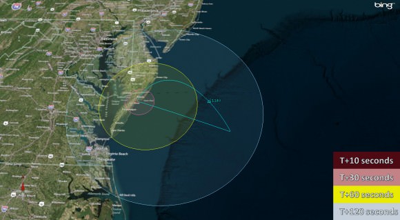
Visibility map for Black Brant V rocket launch on June 24 at 9:30 a.m. Credit: NASA Wallops
A two-stage Terrier-Improved Orion blasts off just 15 seconds later. The 33 foot long rocket carries a canister of lithium gas. It will shoot out a long trail of lithium gas that creates a chemical trail that will be tracked to determine how the upper atmospheric wind varies with altitude. These winds are believed to be the drivers of the dynamo currents.
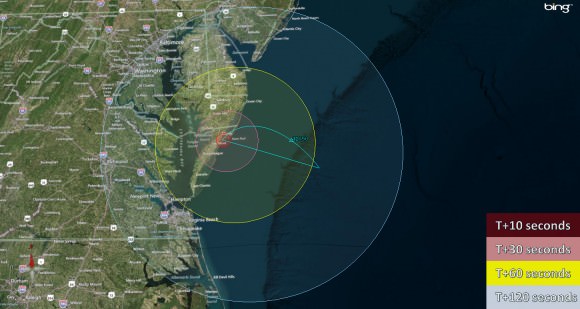
Visibility map for Terrier-Improved Orion rocket launch on June 24 at 9:30 a.m. Credit: NASA Wallops
Both rockets will fly for about five minutes to an altitude of some 100 miles up in the ionosphere.
Since its daytime the lithium trails will be very hard to discern with the naked eye. That’s why NASA is also using a uniquely equipped NASA King Air airplane outfitted with cameras with special new filters optimized to detect the lithium gas and how it is moved by the winds that generate the global electrical current.
The new technology to make the daytime measurements was jointly developed by NASA, JAXA and scientists at Clemson University.
RockOn 2013 University student payload blasts off on June 20,2013 atop a NASA Terrier-Improved Orion suborbital rocket from NASA Wallops at Virginia’s eastern shore. Credit: NASA/Chris Perry
Sounding rockets are better suited to conduct these studies of the ionosphere compared to orbiting satellites which fly to high.
“The manner in which neutral and ionized gases interact is a fundamental part of nature,” said Robert Pfaff, the principle investigator for the Dynamo sounding rocket at NASA’s Goddard Space Flight Center in Greenbelt, Md.
“There could very well be a dynamo on other planets. Jupiter, Saturn, Uranus and Neptune are all huge planets with huge atmospheres and huge magnetic fields. They could be setting up dynamo currents galore.”
The launch window opens at 9:30 a.m. and extends until 11:30 a.m. Back up opportunities are available on June 25 and from June 28 to July 8.
The rockets will be visible to residents in the Wallops region – and also beyond to the US East Coast from parts of North Carolina to New Jersey.
The NASA Wallops Visitor Center will open at 8 a.m. on launch day for viewing the launches.
Live coverage of the June 24 launch is available via NASA Wallops UStream beginning at 8:30 a.m. at: http://www.ustream.tv/channel/nasa-tv-wallops
I will be onsite at Wallops for Universe Today.
And don’t forget to “Send Your Name to Mars” aboard NASA’s MAVEN orbiter- details here. Deadline: July 1, 2013. Launch: Nov. 18, 2013
…………….
Learn more about Earth, Mars, Curiosity, Opportunity, MAVEN, LADEE, Sounding rockets and NASA missions at Ken’s upcoming presentation
June 23: “Send your Name to Mars on MAVEN” and “CIBER Astro Sat, LADEE Lunar & Antares Rocket Launches from Virginia”; Rodeway Inn, Chincoteague, VA, 8 PM
Show here are the two types of sounding rockets that will launch on June 24, 2013 from NASA Wallops Island, VA., on the Daytime Dynamo mission. Black Brant V rocket is horizontal. Terrier-Improved Orion rocket is vertical. Credit: Ken Kremer – kenkremer.comNight time launch of NASA Black Brant XII suborbital rocket at 11:05 p.m. EDT on June 5, 2013 from the NASA Wallops Flight Facility carrying the CIBER astronomy payload. Credit: Ken Kremer- kenkremer.com
Earth’s Vegetation. World map of vegetation created with Suomi NPP data. Credit: NASA/NOAA
Earth’s Vegetation from Suomi NPP satellite. World map of vegetation data collected by the Suomi NPP satellite (National Polar-orbiting Partnership) in a partnership between NASA and the National Oceanic and Atmospheric Administration (NOAA). Credit: NASA/NOAA
Photo and Video Gallery below[/caption]
Herbal Earth: that’s the title of a spectacular collection of vivid new views of the Earth’s vegetation captured over the past year by the Suomi NPP satellite.
NPP is short for National Polar-orbiting Partnership – an Earth science satellite partnership between NASA and the National Oceanic and Atmospheric Administration (NOAA).
Although it’s rather reminiscent of the manmade ‘World at Night’ – its actually the ‘Natural World of Living Green Life.’
The Suomi NPP satellite data were collected with the Visible-Infrared Imager/Radiometer Suite (VIIRS) instrument from April 2012 to April 2013 and used to generate this gallery of images and animations – released by NASA and NOAA on June 19.
Western Hemisphere -Vegetation on Our Planet. The darkest green areas are the lushest in vegetation, while the pale colors are sparse in vegetation cover either due to snow, drought, rock, or urban areas. Suomi NPP Satellite data from April 2012 to April 2013 was used to generate these images. Credit: NASA/NOAA
Suomi NPP was launched on October 28, 2011 by a Delta II rocket and placed into a sun-synchronous orbit 824 km (512 miles) above the Earth. It orbits Earth about 14 times daily.
The VIIRS instrument measures vegetation changes over time by looking at changes in the visible and near-infrared light reflected by vegetation. The 22-band radiometer sensor can detect subtle differences in greenness.
Nile Delta: July 9-15, 2012. Amidst the deserts of Egypt, the Nile River provides life-sustaining water to the region. Also visible are the urbanized areas of northern Egypt. Credit: NASA/NOAA
The data are incorporated into the Normalized Difference Vegetation Index (NDVI) which represents the photosynthetic potential of vegetation.
The NVDI measures and monitors plant growth, vegetation cover and biomass production from the Suomi NPP satellite information.
The Florida Everglades: March 18-24, 2013. The “river of grass” extending south of Lake Okeechobee shows clear signs of its modified state with areas of dense agriculture, urban sprawl and water conservation areas delineated by a series of waterways that crisscross Southern Florida. Credit: NASA/NOAA
A quarter of the Earth’s surface is covered by some green vegetation, the remainder is the blue ocean.
Video: Green- Vegetation on Our Planet (Tour of Earth)
And don’t forget to “Send Your Name to Mars” aboard NASA’s MAVEN orbiter- details here. Deadline Very Soon: July 1, 2013. Launch: Nov. 18, 2013
…………….
Learn more about Earth, Mars, Curiosity, Opportunity, MAVEN, LADEE and NASA missions at Ken’s upcoming presentation
June 23: “Send your Name to Mars on MAVEN” and “CIBER Astro Sat, LADEE Lunar & Antares Rocket Launches from Virginia”; Rodeway Inn, Chincoteague, VA, 8 PM
Eastern Hemisphere -Vegetation on Our Planet. Credit: NASA/NOAA
SPACE! The Gallery Show will feature space-themed art such as this piece by Joe Van Wetering. Credit: SPACE! The Gallery Show
Space fans in Los Angeles — and we know, given Mars Curiosity is controlled at the nearby NASA Jet Propulsion Laboratory, that there are lots of you — here’s a neat-looking art show for you to check out in the next month.
SPACE! The Gallery Show will open at Gallery 1988: West today with special NASA guest Bobak Ferdowsi, a systems engineer at JPL who is best known as “Mohawk Guy” — that person with the great haircut being shown on television screens worldwide during the Curiosity landing.
“You guys, I am thrilled to finally share this with you,” wrote organizer Mike Mitchell on his blog. “It’s the first time I’ve ever curated a show, and it’s a theme that I’m very passionate about. Take a gander at the artist list, get yourself pumped up and come to the show. It’s going to be a stellar time.”
The event runs today through Saturday, July 20, closing on the 44th anniversary of the Apollo 11 landing. More information is available on the event’s Facebook page and the gallery’s website.
Hat-tip to Laughing Squid, whose post alerted us to the show.
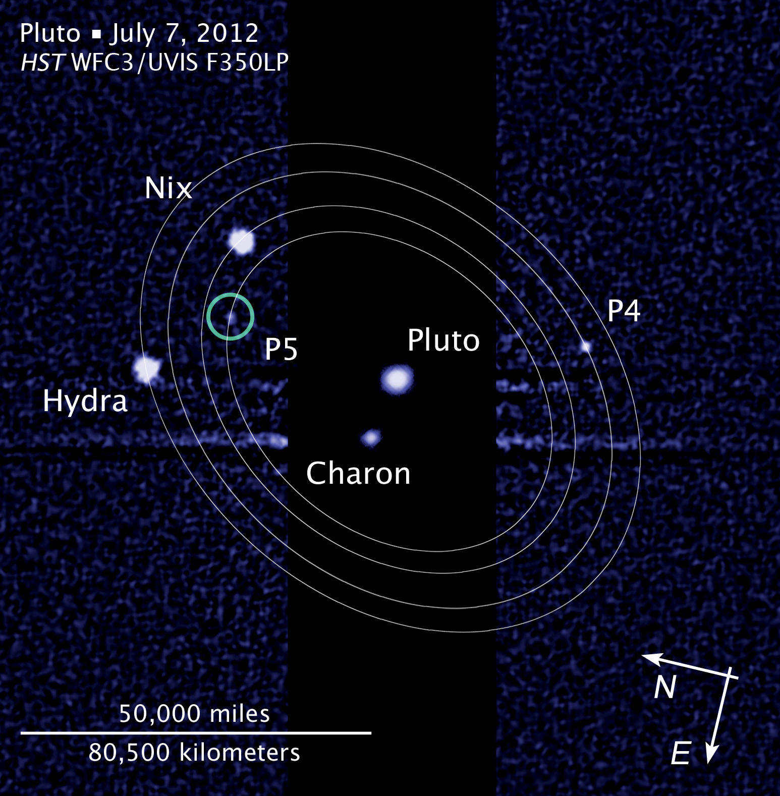
The Pluto and Charon Binary Planet System imaged by the Hubble Space Telescope. NASA’s New Horizons spacecraft will pass through in 2015 using the original baseline trajectory . Credit: Hubble Space Telescope
Following an intense 18 month study to determine if NASA’s New Horizons spacecraft faced potentially destructive impact hazards during its planned 2015 flyby of the Pluto binary planet system, the mission team has decided to ‘stay the course’ – and stick with the originally planned trajectory because the danger posed by dust and debris is much less than feared.
The impact assessment study was conducted because the Pluto system was discovered to be much more complex – and thus even more scientifically compelling – after New Horizons was launched in January 2006 from Cape Canaveral in Florida.
Two years ago researchers using the iconic Hubble Space Telescope discovered two new moons orbiting around Pluto, bringing the total to 5 moons!
It was feared that debris hitting the moons could have created dangerous dust clouds that in turn would slam into and damage the spacecraft as it zoomed past Pluto at speeds of some 30,000 miles per hour (more than 48,000 kilometers per hour) in July 2015.
“We found that loss of the New Horizons mission by dust impacting the spacecraft is very unlikely, and we expect to follow the nominal, or baseline, mission timeline that we’ve been refining over the past few years,” says New Horizons Project Scientist Hal Weaver, of the Johns Hopkins University Applied Physics Laboratory, in a statement.
After both the team and an independent review board and NASA thoroughly analyzed the data, it was determined that New Horizons has only a 0.3 percent chance of suffering a mission destroying dust impact event using the baseline trajectory.
Hubble Space Telescope view of Pluto and its known moons.
The 0.3 percent probability of mission loss is far less than some earlier estimates.
This is really good news because the team can focus most of its efforts on developing the flyby encounter science plan when New Horizons swoops to within about 12,500 kilometers (nearly 7,800 miles) of Pluto’s surface.
Pluto forms a “double planet” system with Charon, its largest moon. Charon is half the size of Pluto.
But the team will still expend some effort on developing alternative trajectories – known as SHBOTs, short for Safe Haven by Other Trajectories, just in case new information arises from the ships camera observations that would force a change in plans as New Horizons sails ever closer to Pluto.
“Still, we’ll be ready with two alternative timelines, in the event that the impact risk turns out to be greater than we think,” says Weaver.
Indeed the team, led by Principal Investigator Alan Stern, of the Southwest Research Institute is finalizing the encounter plan this month and plans a rehearsal in July of the most critical nine-day segment of the baseline flyby trajectory.
New Horizons will perform the first reconnaissance of Pluto and Charon in July 2015. The “double planet” is the last planet in our solar system to be visited by a spacecraft from Earth.
And New Horizons doesn’t’ stop at Pluto. The goal is to explore one or more of the icy Kuiper Belt Objects (KBO’s) further out in the Solar System.
The team will use the Pluto flyby to redirect New Horizons to a KBO that is yet to be identified.
And don’t forget to “Send Your Name to Mars” aboard NASA’s MAVEN orbiter- details here. Deadline: July 1, 2013. Launch: Nov. 18, 2013
…………….
Learn more about Pluto, Mars, Curiosity, Opportunity, MAVEN, LADEE and NASA missions at Ken’s upcoming lecture presentations
June 23: “Send your Name to Mars on MAVEN” and “CIBER Astro Sat, LADEE Lunar & Antares Rocket Launches from Virginia”; Rodeway Inn, Chincoteague, VA, 8 PM
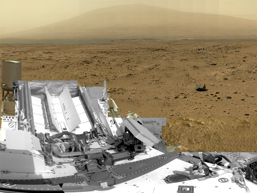
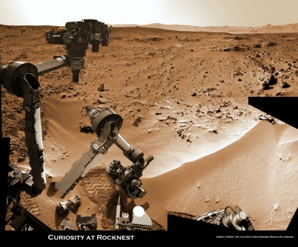
This is a cropped, reduced version of panorama from NASA's Mars rover Curiosity with 1.3 billion pixels in the full-resolution version see full panorama below. It shows Curiosity at the "Rocknest" site where the rover scooped up samples of windblown dust and sand. Curiosity used three cameras to take the component images on several different days between Oct. 5 and Nov. 16, 2012. Viewers can explore this image with pan and zoom controls at http://mars.nasa.gov/bp1/. Credit: NASA/JPL-Caltech/MSSS
This is a cropped, reduced version of panorama from NASA’s Mars rover Curiosity with 1.3 billion pixels in the full-resolution version. See full panorama below. It shows Curiosity at the “Rocknest” site where the rover scooped up samples of windblown dust and sand. Curiosity used three cameras to take the component images on several different days between Oct. 5 and Nov. 16, 2012. Viewers can explore this image with pan and zoom controls at http://mars.nasa.gov/bp1/. Credit: NASA/JPL-Caltech/MSSS Updated with link to interactive Gigapan version
[/caption]
NASA’s newly produced and absolutely spectacular panorama from the Curiosity mega rover offers armchair explorers back on Earth a mammoth 1.3 billion pixels worth of Mars in all its colorful glory.
And everyone can move back and forth around the interactive panorama and zoom in – with special embedded tools- to your hearts delight in exquisite detail at the ‘Rocknest’ site where the rover spent her first extended science stay in late 2012.
This extra special Rocknest panorama is the first NASA- produced view comprising more than a billion pixels from the surface of the Red Planet.
It offers a full 360 degree panoramic view around the rover encompassing breathtaking vistas of Mount Sharp and the eerie rim of Gale Crater, some 20 miles distant.
Mount Sharp rises 3.4 miles (5.5 km) high and is the target destination. The team hopes Curiosity will arrive at the base of Mount Sharp perhaps late this year or early in 2014.
The ‘Rocknest’ scene was assembled from nearly 900 raw images snapped by three different cameras among the 17 total that Curiosity uses as she trundles across the crater floor in search of the ingredients of life.
Billion-Pixel View From Curiosity at Rocknest, Raw Color. This full-circle, reduced view combined nearly 900 images taken by NASA’s Curiosity Mars rover, generating a panorama with 1.3 billion pixels in the full-resolution version. The view is centered toward the south, with north at both ends. It shows Curiosity at the “Rocknest” site where the rover scooped up samples of windblown dust and sand. Curiosity used three cameras to take the component images on several different days between Oct. 5 and Nov. 16, 2012. Credit: NASA/JPL-Caltech/MSSS
The panorama was created by Bob Deen of the Multi-Mission Image Processing Laboratory at NASA’s Jet Propulsion Laboratory, Pasadena, Calif, where the mission is managed on a daily basis.
“It gives a sense of place and really shows off the cameras’ capabilities,” said Deen in a statement. “You can see the context and also zoom in to see very fine details.”
Check here for the full, billion pixel interactive cylindrical and panoramic viewers
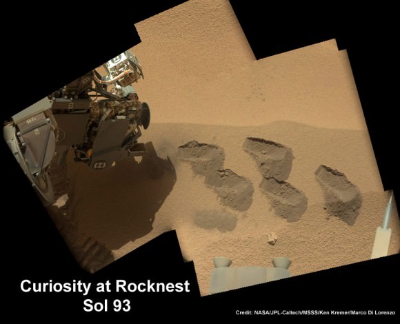
“Rocknest” was a windblown ripple of sand dunes that Curiosity drove to after departing from the touchdown site at ‘Bradbury Landing’ and thoroughly investigated in October and November 2012.
It was at ‘Rocknest’ where the six wheeled rover famously deployed her robotic arm to scoop into the Martian dirt for the very first time and then delivered those first grains to the duo of analytical chemistry labs inside her belly that lie at the heart of Curiosity’s science mission.
Deen assembled the color product using 850 raw images from the 100 mm telephoto camera of Curiosity’s Mast Camera instrument, supplemented with 21 more from the Mastcam’s wider-angle 34 mm camera.
In order to take in the rover itself, the view also included 25 black-and-white raw images from the Navigation Camera on the Mast.
All the images were taken between Oct. 5 and Nov. 16, 2012 while the rover was stationary at Rocknest.
And check this link to a new NASA JPL Curiosity gallery on the GigaPan website – here
Because the images were captured over many days and at different times of day, the lighting and atmospheric clarity varies – especially in distant views to the crater rim.
Since landing on August 6, 2012, Curiosity has already accomplished her primary goal of finding a habitable zone at Gale Crater with an environment that could once of supported Martian microbial life – at the current worksite at ‘Yellowknife Bay.’
Time lapse context view of Curiosity maneuvering her robotic arm to conduct close- up examination of windblown ‘Rocknest’ ripple site. Curiosity inspects “bootlike” wheel scuff mark with the APXS (Alpha Particle X-Ray Spectrometer) and MAHLI (Mars Hand Lens Imager) instruments positioned on the rotatable turret at the arm’s terminus. Mosaic stitched from Navcam images on Sols 57 & 58 shows the arm in action just prior to 1st sample scooping here. Eroded rim of Gale Crater rim is visible on the horizon. Credit: NASA/JPL-Caltech/Ken Kremer (kenkremer.com)/Marco Di Lorenzo
The 1 ton robot is equipped with 10 state-of-the-art science instruments with research capabilities that far surpass any prior landed mission and is in the middle of the 2-year primary mission to the Red Planet.
Meanwhile, Curiosity’s older sister rover Opportunity has also discovered clay minerals and a habitable zone on the opposite side of the Red Planet – details here.
And don’t forget to “Send Your Name to Mars” aboard NASA’s MAVEN orbiter- details here. Deadline: July 1, 2013
…………….
Learn more about Mars, Curiosity, Opportunity, MAVEN, LADEE and NASA missions at Ken’s upcoming lecture presentations
June 23: “Send your Name to Mars on MAVEN” and “CIBER Astro Sat, LADEE Lunar & Antares Rocket Launches from Virginia”; Rodeway Inn, Chincoteague, VA, 8 PM
Curiosity scooped 5 times into Martian soil at Rocknest windblown ripple and delivered samples to the SAM chemistry instrument for analysis. This color mosaic was stitched together from hi-res color images taken by the robots 34 mm Mastcam camera on Sols 93 and 74. Credit: NASA / JPL-Caltech /MSSS/Ken Kremer (kenkremer.com)/Marco Di Lorenzo
We love a good space debris mystery. Hey, who doesn’t, right? Regular readers of Universe Today know that it’s a shooting gallery out there, from meteor fireballs caught on dashboard cams to rogue space junk reentries lighting up our skies.
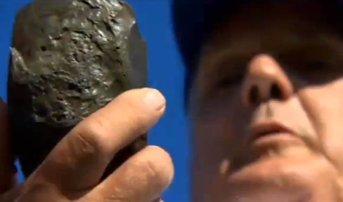
But an unusual story that made its rounds across the internet this past weekend caught our attention. What at first glance was a simple “Man finds space rock” story morphed into an extraordinary claim, which, in the words of the late great Carl Sagan, “demand extraordinary evidence.”
The find was made by Phil Green of Amesbury, Massachusetts. Mr. Green was searching the local riverbed for arrowheads when he came across the unusual find. The black pitted rock immediately struck him as something bizarre. It didn’t register as metallic to his metal detector, but Mr. Green kept it in his backyard for about five years until it was noticed by a friend.
“I didn’t really think much of it, and then a fellow came over, saw it and said that’s a meteor,” Green told local reporters.
From here, the story takes a strange turn. Green told local reporters that the rock was sent off for analysis, only to be returned to him just a few weeks ago. The analysis confirmed that the rock was indeed from space… sort of. It also stated that the vitreous material “shows a composition similar to that used in ballast by the Soviet space program starting in the mid-1980s.”
There are just a few problems with the tale. Mir reentered in 2001, six years before the 2007. A few articles do bother to note this, mentioning that Mir ended its career in the “so-called spacecraft cemetery of the southern Pacific Ocean,” about as far away from Massachusetts as you can get.
A few articles do also mention the possibility of a reentry of a Progress resupply vehicle being a potential source, or perhaps an unrelated Russian space vehicle.
But there seems to be a potential problem of the certification. Several articles state that the piece of debris coming from Mir was “confirmed by NASA.” However, Universe Today contacted NASA Chief Scientist for Orbital Debris Nicholas L. Johnson and NASA Headquarters official Joshua Buck, who both told us that no such NASA validation exists. Mr. Johnson went on to tell Universe Today that, “The NASA Orbital Debris Program Office has not been presented with any claim regarding debris from the Mir space station,” adding “I can tell you that it is not possible for debris from the Mir reentry to have landed in the U.S.”
A name that occasionally turns up in reports online as validating the find (withheld by request) also tells Universe Today that they had nothing to do with the discovery. Mr. Green or the original validation source have thus far been unavailable for comment.
We did uncover two documented reentries that occurred over the general region over the last few decades. One is the reentry of Mir-R 1986-017B (The rocket booster that launched the core module of Mir) seen from a trans-Atlantic airliner on February 24th 1986 about 500 kilometres off of the east coast of Newfoundland. Another possible suspect is the June 26/27th 2004 reentry of a SL-12 auxiliary rocket motor with the NORAD ID 1992-088E, seen to the west from New Jersey to Ontario.
Like the International Space Station, Mir was placed in a 51.6° inclined orbit. This made it accessible from the Baikonur Cosmodrome as well as visits from the U.S. Space Shuttle. Payloads going to and from the station would cover an identical ground track ranging from 51.6° north to south latitude.
The story is also reminiscent of the reentry of debris from Sputnik 4, which struck a small town in Wisconsin in 1962. This was analyzed by mineralogist Ursula Marvin and confirmed to be of Russian origin.
A Progress spacecraft inbound for docking with the International Space Station. (Credit: NASA).
Probably the biggest question in our minds is: what links the object back to an errant Russian spacecraft? What do they use for ballast, anyhow? How did they arrive at the often quoted “85% certainty?” of the object’s origin?
Still, the find does look like something interesting. The pitting and the melted fusion crust are all reminiscent of reentry. We’ll keep researching this story, and for the time being we’ll leave it up to you, the diligent and insightful readers of Universe Today, to make up your own minds on this strange and interesting tale.
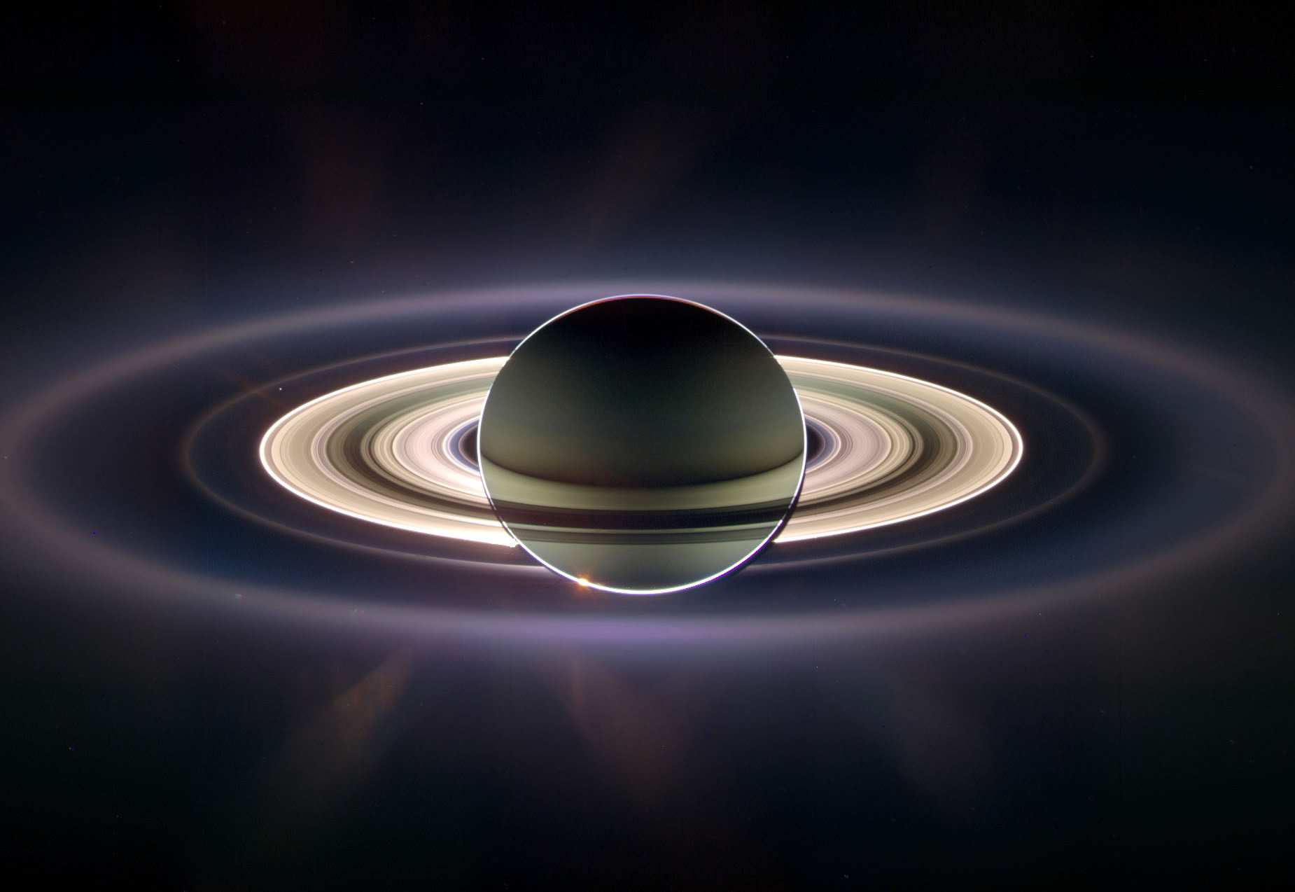
Mosaic of Saturn seen in eclipse in September 2006. Earth is the bright dot just inside the F ring at upper left. (CICLOPS/NASA/JPL-Caltech/SSI)
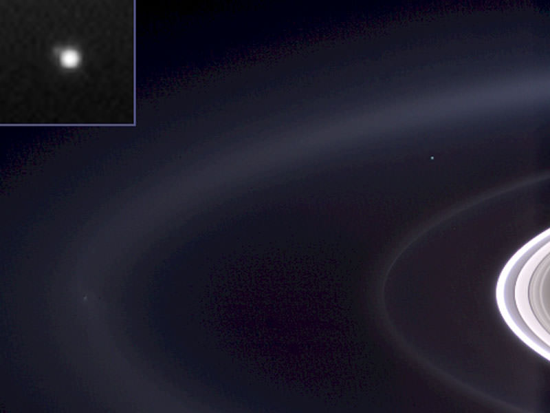
Citizens of Earth, get ready for your Cassini close-up: once again the spacecraft is preparing to capture images of Saturn positioned between it and the Sun, allowing for incredible views of the ring system and its atmosphere — and also a tiny “pale blue dot” in the distance we call home.
Earth seen from Cassini (NASA/JPL/SSI)
The mosaic above was composed of images captured during such an eclipse event in September 2006, and quickly became an astronomical sensation. It’s not often we get an idea of what we look like from so far away, and seeing our entire world represented as a small speck of light nestled between Saturn’s rings is, to me anyway, both impressive and humbling.
Humbling because of how small we look, but impressive because as a species we have found a way to do it.
And next month, on Friday, July 19 between 21:27 and 21:42 UTC (5:27 – 5:42 p.m. EDT) Cassini will do it again.
“Ever since we caught sight of the Earth among the rings of Saturn in September 2006 in a mosaic that has become one of Cassini’s most beloved images, I have wanted to do it all over again, only better,” said Cassini imaging team leader, Carolyn Porco. “And this time, I wanted to turn the entire event into an opportunity for everyone around the globe, at the same time, to savor the uniqueness of our beautiful blue-ocean planet and the preciousness of the life on it.”
Porco was involved in co-initiating and executing the famous “Pale Blue Dot” image of Earth taken by NASA’s Voyager 1 from beyond the orbit of Neptune in 1990.
“It will be a day for all the world to celebrate,” she said.
The intent for the upcoming mosaic is to capture the whole scene, Earth and Saturn’s rings from one end to the other, in Cassini’s red, green and blue filters that can be composited to form a natural color view of what our eyes might see at Saturn. Earth and the Moon will also be imaged with a high resolution camera — something not yet done by Cassini.
We can all consider ourselves pretty lucky, too… this is the first time in history that we humans will know in advance that our picture is going to be taken from nearly a billion miles away.
“While Earth will be only about a pixel in size from Cassini’s vantage point 898 million miles [1.44 billion kilometers] away, the Cassini team is looking forward to giving the world a chance to see what their home looks like from Saturn,” said Linda Spilker, Cassini project scientist at NASA’s Jet Propulsion Laboratory. “With this advance notice, we hope you’ll join us in waving at Saturn from Earth, so we can commemorate this special opportunity.”
So on July 19, remember to look up and wave… Cassini will be watching!
Read more on the CICLOPS news release here and on the NASA/JPL Cassini mission site here.
“That’s here. That’s home. That’s us. On it everyone you love, everyone you know, everyone you ever heard of, every human being who ever was, lived out their lives… There is perhaps no better demonstration of the folly of human conceits than this distant image of our tiny world.”
On Monday, NASA introduced eight new astronaut candidates – four women and four men – who will “help the agency push the boundaries of exploration and travel to new destinations in the solar system,” NASA said.
“This is the first class in three years, and the 21st overall in our nation’s nearly 55-year journey in space,” said NASA Associate Administrator Lori Garver in a blog post. “From a near-record number of applicants, more than 6,100, we selected an extremely qualified class that represents a high degree of achievement and dedication to our nation’s future.”
This is the highest percentage of female candidates ever selected for a class.
“That was not by choice or by determination,” said Janet Kavandi, a veteran astronaut and the director of Flight Crew Operations for NASA, speaking during a Google Plus Hangout where the new astronauts were introduced. “We never determine how many people of each gender we’re going to take, but these were the most qualified people of the ones that we interviewed. They earned every bit of the right to be there.”
Kavandi added that the new class is “an amazing group of people.”
You can watch a replay of the Hangout below:
The new astronauts candidates will undergo several years of training to become official astronauts. Right now NASA has 48 in the astronaut corps, which is about one-third the size it was at its peak a during the space shuttle heydays.
“With a smaller astronaut corps and fewer people in the office, now each person needs to have as diverse a background as possible” Kavandi said, “so we tried to work hard to make sure that the eight people we got had a broad spectrum of experiences, and I think you can tell that from their qualifications.”
NASA said the new astronauts will receive a wide array of technical training to prepare for missions to low-Earth orbit, an asteroid and Mars.
“These new space explorers asked to join NASA because they know we’re doing big, bold things here — developing missions to go farther into space than ever before,” said NASA Administrator Charles Bolden. “They’re excited about the science we’re doing on the International Space Station and our plan to launch from U.S. soil to there on spacecraft built by American companies. And they’re ready to help lead the first human mission to an asteroid and then on to Mars.”
The new astronaut candidates are:
Josh A. Cassada, Ph. D., 39, is originally from White Bear Lake, Minn. Cassada is a former naval aviator who holds an undergraduate degree from Albion College, and advanced degrees from the University of Rochester, N.Y. Cassada is a physicist by training and currently is serving as co-founder and Chief Technology Officer for Quantum Opus.
Victor J. Glover, 37, Lt. Commander, U.S. Navy, hails from Pomona, Calif., and Prosper, Texas. He is an F/A-18 pilot and graduate of the U.S. Air Force Test Pilot School. Glover holds degrees from California Polytechnic State University, San Luis Obispo, Calif.; Air University and Naval Postgraduate School. He currently is serving as a Navy Legislative Fellow in the U.S. Congress.
Tyler N. Hague (Nick), 37, Lt. Colonel, U.S. Air Force, calls Hoxie, Kan., home. He is a graduate of the U.S. Air Force Academy, Massachusetts Institute of Technology, and the U.S. Air Force Test Pilot School, Edwards, Calif. Hague currently is supporting the Department of Defense as Deputy Chief of the Joint Improvised Explosive Device Defeat Organization.
Christina M. Hammock, 34, calls Jacksonville, N.C. home. Hammock holds undergraduate and graduate degrees from North Carolina State University, Raleigh, N.C. She currently is serving as National Oceanic and Atmospheric Administration (NOAA) Station Chief in American Samoa.
Nicole Aunapu Mann, 35, Major, U.S. Marine Corps, originally is from Penngrove, Calif. She is a graduate of the U.S. Naval Academy, Stanford (Calif.) University and the U.S. Naval Test Pilot School, Patuxent River, Md. Mann is an F/A 18 pilot, currently serving as an Integrated Product Team Lead at the U.S. Naval Air Station, Patuxent River.
Anne C. McClain, 34, Major, U.S. Army, lists her hometown as Spokane, Wash. She is a graduate of the U.S. Military Academy at West Point, N.Y.; the University of Bath and the University of Bristol, both in the United Kingdom. McClain is an OH-58 helicopter pilot, and a recent graduate of U.S. Naval Test Pilot School at Naval Air Station, Patuxent River.
Jessica U. Meir, Ph.D., 35 is from Caribou, Maine. She is a graduate of Brown University, has an advanced degree from the International Space University, and earned her doctorate from Scripps Institution of Oceanography. Meir currently is an Assistant Professor of Anesthesia at Harvard Medical School, Massachusetts General Hospital, Boston.
Andrew R. Morgan, M.D., 37, Major, U.S. Army, considers New Castle, Pa., home. Morgan is a graduate of The U.S. Military Academy at West Point, and earned doctorate in medicine from the Uniformed Services University of the Health Sciences, Bethesda, Md. He has experience as an emergency physician and flight surgeon for the Army special operations community, and currently is completing a sports medicine fellowship.
You can read more about each of the astronauts here.
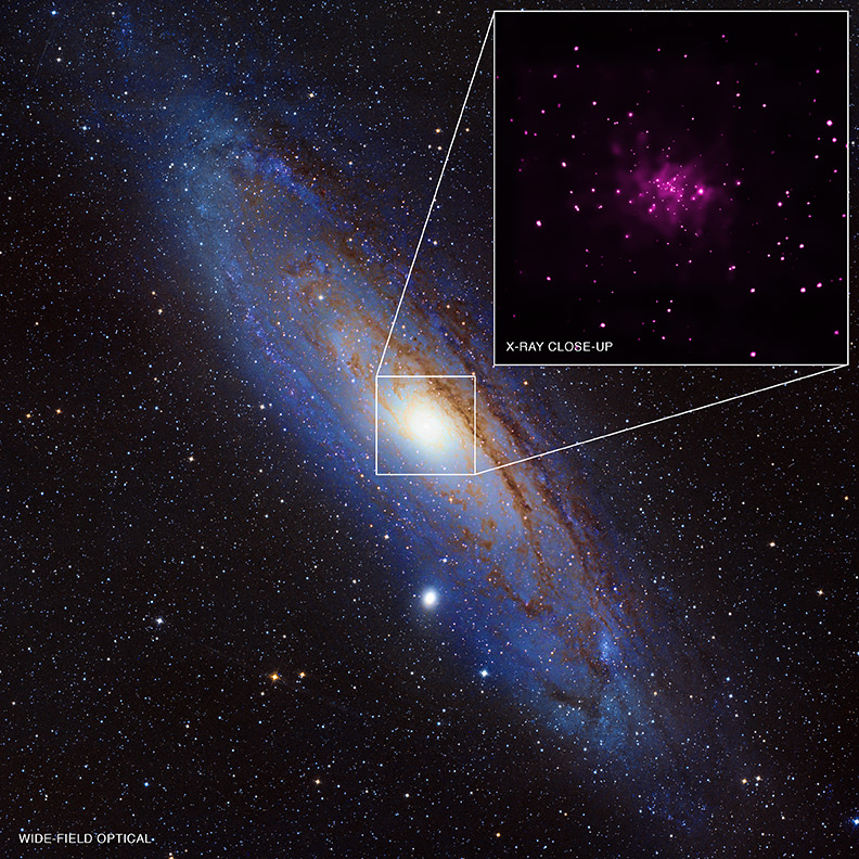
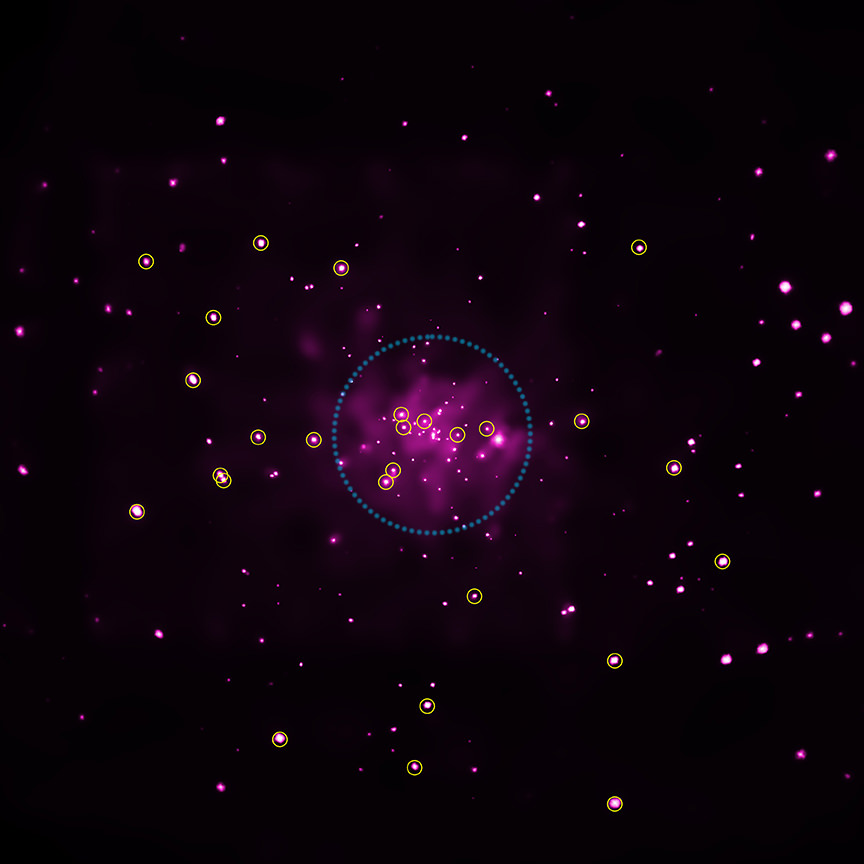
A new analysis of data from the Chandra space telescope revealed 26 black hole candidates in the Andromeda Galaxy. This is the largest collection of possible black holes found in another galaxy besides that of the Milky Way, Earth's home galaxy. Credit: X-ray (NASA/CXC/SAO/R.Barnard, Z.Lee et al.), Optical (NOAO/AURA/NSF/REU Prog./B.Schoening, V.Harvey; Descubre Fndn./CAHA/OAUV/DSA/V.Peris)
More than two DOZEN potential black holes have been found in the nearest galaxy to our own. As if that find wasn’t enough, another research group is teaching us why extremely high-energy X-rays are present in black holes.
The Andromeda Galaxy (M31) is home to 26 newly found black hole candidates that were produced from the collapse of stars that are five to 10 times as massive as the sun.
Using 13 years of observations from NASA’s Chandra X-Ray Observatory, a research team pinpointed the locations. They also corroborated the information with X-ray spectra (distribution of X-rays with energy) from the European Space Agency’s XMM-Newton X-ray observatory.
“When it comes to finding black holes in the central region of a galaxy, it is indeed the case where bigger is better,” stated co-author Stephen Murray, an astronomer at Johns Hopkins University and the Harvard-Smithsonian Center for Astrophysics.
A close-up of the candidate black holes in Andromeda, as seen by the Chandra X-Ray Observatory. Credit: X-ray (NASA/CXC/SAO/R.Barnard, Z.Lee et al.), Optical (NOAO/AURA/NSF/REU Prog./B.Schoening, V.Harvey; Descubre Fndn./CAHA/OAUV/DSA/V.Peris
“In the case of Andromeda, we have a bigger bulge and a bigger supermassive black hole than in the Milky Way, so we expect more smaller black holes are made there as well,” Murray added.
The total number of candidates in M31 now stands at 35, since the researchers previously identified nine black holes in the area. All told, it’s the largest number of black hole candidates identified outside of the Milky Way.
Meanwhile, a study led by the NASA Goddard Space Flight Center examined the high-radiation environment inside a black hole — by simulation, of course. The researchers performed a supercomputer modelling of gas moving into a black hole, and found that their work helps explain some mysterious X-ray observations of recent decades.
Researchers distinguish between “soft” and “hard” X-rays, or those X-rays that have low and high energy. Both types have been observed around black holes, but the hard ones puzzled astronomers a bit.
Here’s what happens inside a black hole, as best as we can figure:
– Gas falls towards the singularity, orbits the black hole, and gradually becomes a flattened disk;
– As gas piles up in the center of the disk, it compresses and heats up;
– At a temperature of about 20 million degrees Fahrenheit (12 million degrees Celsius), the gas emits “soft” X-rays.
So where did the hard X-rays — that with energy tens or even hundreds of times greater than soft X-rays — come from? The new study showed that magnetic fields are amplified in this environment that then “exerts additional influence” on the gas, NASA stated.
Artist’s conception of the Chandra X-Ray Observatory. Credit: NASA
“The result is a turbulent froth orbiting the black hole at speeds approaching the speed of light. The calculations simultaneously tracked the fluid, electrical and magnetic properties of the gas while also taking into account Einstein’s theory of relativity,” NASA stated.
One key limitation of the study was it modelled a non-rotating black hole. Future work aims to model one that is rotating, NASA added.
You can check out more information about these two studies below:


