Mars500 crew just seconds before ingressing their module for a 520 day stay in June 2010. Credit: ESA
[/caption]
Six men from Europe, Russia and China embarked on a 520-day mock mission to Mars, heading out to a crew module in a warehouse in Moscow and locking the hatches behind them today. The mission runs from June 2010 to November 2011, and like a real Mars mission, the crew will live and work like astronauts, eating special food and exercising the same way as crews aboard the International Space Station. Additionally their communications with their mission control and anyone else from the rest of the world will have a delay of up to 40 minutes.
A joint project between the Russian space agency and ESA, officials said the mood was serious, intense but very determined in the Mars500 facility at the Institute of Biomedical Problems in Moscow as the crew talked to the press and then walked into the modules.
Diego Urbina and Romain Charles from Europe, Sukhrob Kamolov, Alexey Sitev, Alexandr Smoleevskiy and Mikhail Sinelnikov from Russia and Wang Yue from China will have a mission that is as ‘real’ as possible. Their mission is to ‘fly to Mars’ in 250 days, divide in two groups, ‘land on and explore Mars’ for a month and ‘return to Earth’ in 230 days, in their special facility imitating an interplanetary spacecraft, lander and Martian terrain. The Mars 500 facility. Credit: ESA
“It will be trying for all of us. We cannot see our family, we cannot see our friends, but I think it is all a glorious time in our lives,” said Chinese participant Wang Yue, 27, ahead of the experiment.
In addition to evaluating many new technologies, Mars500 will test of human endurance and psychological issues of being confined in a small space and being away from family and friends and a normal Earth-life.
The crew will be keeping online diaries and provide video updates to ESA’s Mars500 site.
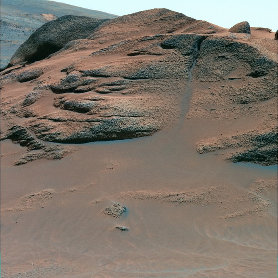
Seen close up, the Comanche outcrop shows both a granular texture and multiple layers. Scientists think it is volcanic debris draped over preexisting terrain. After it was deposited, the rock was soaked in hydrothermal water rich in carbonate minerals. False-color Pancam image. Credit: NASA/JPL/Cornell University
[/caption]
Even though the Mars Rover Spirit is asleep, a new look at old data from one of her instruments confirms the presence of large amounts of carbonate-rich rocks, which means that regions of the planet may have once harbored water. The Miniature Thermal Emission Spectrometer, or Mini-TES, instrument on the rover looked at an outcrop of rocks called “Comanche” back in 2005, but the instrument was partially “blinded” by dust. Only when scientists developed a special calibration to remove the spectral effects of the dust on the instrument was the spectral data revealed to show evidence for carbonate-rich outcrops in a range of low hills inside Gusev crater on Mars.
Spirit has gone into hibernation because of low power levels during the extremely cold winter months on Mars. She is stuck in some loose sand in the Home Plate region, and the rover teams were unable to get her solar panels in a good position to soak up the sun’s energy.
”]
See more images of Comanche, below, courtesy of Stu Atkinson.
Carbonates are clues to neutral pH conditions, and the mineral forms readily in the presence of water and a carbon dioxide atmosphere. If conditions were right for carbonate-bearing rocks to form, water would have been present, and could have created an environment favorable to life. Yet until now, geologic clues for the presence of carbonates on the surface of Mars have been scarce.
“Mini-TES got dusted months before Spirit reached Comanche, and we didn’t have a good way to correct for the dust effects at the time,” said Steve Ruff, research scientist at Arizona State University’s Mars Space Flight Facility. Ruff is one of a team of scientists on the paper, whose lead author is Richard V. Morris of NASA’s Johnson Space Center in Houston. “We knew there was something weird about the outcrop’s spectrum as seen by Mini-TES, but couldn’t say what caused it.”
Ruff said that even though Spirit’s Mössbauer spectrometer indicated that carbonate was possible, the team needed more evidence to be convinced. When the calibration method to remove the spectral effects of the dust made that data available, and combined with chemical data from a third spectrometer, “the Mini-TES spectra put the discovery over the edge,” Ruff said.
Scientists have been searching for Martian carbonate rocks for decades because such minerals are crucial to understanding the early climate history of Mars and the related question of whether the planet might once have held life. Part of the Pancam “Seminole Panorama” taken near the Seminole outcrop on the southeast slope of Husband Hill. Home Plate and the Comanche outcrops are visible in this image. Image courtesy of NASA/JPL/Cornell. http://pancam.astro.cornell.edu Image captions
Small amounts of carbonate minerals have been detected on Mars before, but Ruff said this new data is different. “We’re seeing a couple of large outcrops of rock poking through the soil of the Columbia Hills,” he said. “The rocks are about 25 percent carbonate by weight, by far the highest abundance we’ve seen on Mars.”
The mineral is rich in magnesium and iron and possibly formed a long time ago by precipitation from the hot, residual waters from leftover magma that flowed through buried carbonate deposits.
NASA’s other Mars rover, Opportunity, has discovered ample evidence for alteration of rocks by water in Meridiani Planum, on the other side of Mars from Spirit’s Gusev Crater. But the water at Meridiani was strongly acidic. While life can evolve to survive in acidic conditions — such as in some of Yellowstone National Park’s geysers and hot springs — few scientists think it can start under those conditions.
Moreover, acidic water quickly destroys carbonate minerals, as for example vinegar dissolves hard water deposits. Thus finding outcrops of carbonate rock shows that the hydrothermal water at Comanche was liquid, chemically neutral, and abundant.
While there’s no evidence for life, Ruff says, the conditions would have been more favorable for it.
Ruff added that more old data from Spirit could hold new clues to Mars’ past. “The Comanche data have been available to scientists and the public for about four years now. The new finding shows that this data set still harbors potentially major discoveries.”
More images of Comanche, rendered by Stu Atkinson:
Panorama of the Comanche outcrop. Credit: NASA/JPL, rendered by Stuart Atkinson.Another color view of Comanche. Credit: NASA/JPL, colorization by Stuart Atkinson.D view of Comanche. Credit: NASA/JPL, 3-D by Stuart Atkinson
What would it be like to approach Mars in a spacecraft? In one of the coolest movies ever, we now know! Using the the Visual Monitoring Camera (VMC) on board Mars Express, science teams put together 600 individual still images to create a movie of descending towards and then moving away from Mars. It shows the spacecraft’s slow descent from high above the planet, speeding up as closest approach is passed and then slowing down again as the distance increases. Continue reading “Mars Webcam Provides Astronaut-like View of Red Planet”
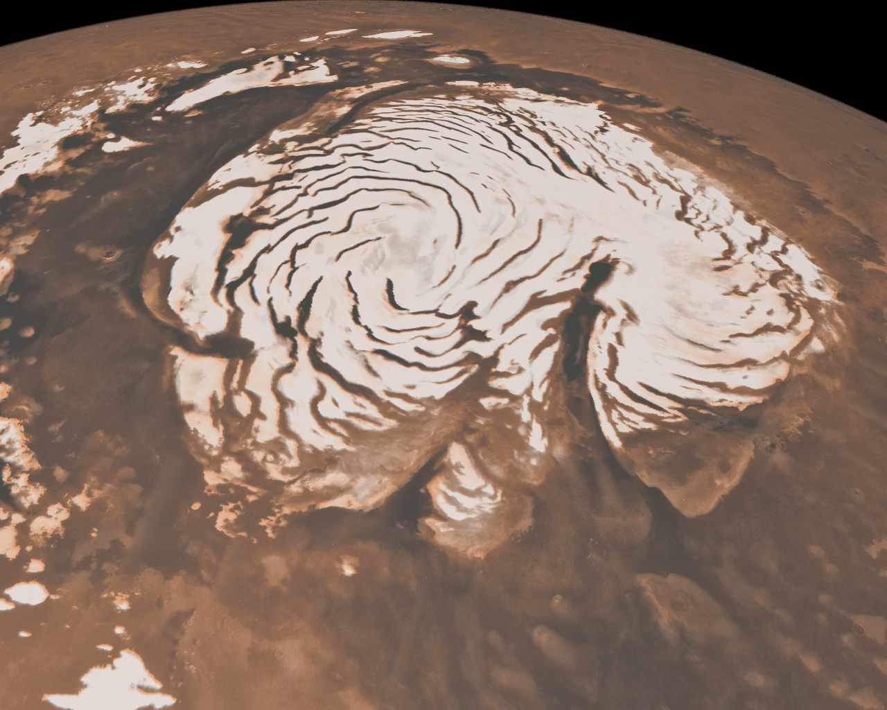
The spiral troughs and gian canyon Chasma Borale have puzzled scientists for 40 years.
[/caption]
The shape of the two-mile-tall Texas-sized ice cap at the north pole of Mars has puzzled scientists for forty years, but new results to be published in a pair of papers in the journal Nature on May 27 have put the controversy to rest.
The polar caps of Mars have been known since the first telescopic views of the planet, but early spacecraft images revealed that the north polar cap is scored by enigmatic troughs that spiral out from its center, as well as a chasm larger than the Grand Canyon. The origin of these features has been debated since they were first discovered in 1972.
One hypothesis to explain the giant canyon, called Chasma Boreale, is that volcanic heat melted the ice and caused a catastrophic flood that formed the chasm. Other scientists have suggested that wind sweeping downhill from the top of the cap carved Chasma Boreale from the ice.
Multiple explanations have been suggested for the spiral troughs too. One explains the troughs as fractures caused by the flow of ice from the pole. Another uses a model to suggest that the troughs are the natural result of solar heating and lateral heat conduction in the ice.
The two new papers, led by Jack Holt and Isaac Smith of The University of Texas at Austin’s Institute for Geophysics, used data from the Shallow Subsurface Radar (SHARAD) on the Mars Reconnaissance Orbiter (MRO) to study the internal structure of the ice cap and discover the origin of the troughs and the chasm.
“SHARAD sends pulses of radio waves from orbit, 700 times per second,” Holt explained. “Some energy is reflected from the surface, and then from subsurface interfaces if the intervening material allows the radio waves to penetrate. Radar at this wavelength (about 20 meters) penetrates ice very well, and it has been used from airplanes on Earth to map large portions of Earth’s ice sheets.”
“By putting all of the reflections together one can make an image of what lies beneath the
surface,” Smith added.
Holt explained that the ability to map not only the surface features but also the internal structure of the ice cap “opens the door to better understand what we see on the surface by providing critical context in time.”
Top: An example SHARAD radar cross section of the martian north polar cap. Bottom: An annotated version of the same cross-section.
By mapping the three-dimensional structure of the north polar ice cap, Smith and Holt have determined that both the troughs and Chasma Boreale were formed by katabatic winds, which blow down from the top of the ice cap.
“We aren’t saying they were carved by wind, rather that wind had a strong role in their formation and evolution.” Holt said. “Chasma Boreale is an old feature that persisted because new ice did not accumulate there, likely due to persistent winds coming from the highest point on the ice cap.”
Holt also discovered evidence for another old canyon that has been completely filled in over time. “No evidence remains on the surface to indicate that it was there previously,” Holt said. “We can map it in the radar data, however.”
The spiral troughs likewise are controlled by the wind. “The radar layers we see show evidence for wind transport because they vary in thickness and elevation [across the troughs],” Smith, lead author of the trough paper, explained. “The wind moves across the trough instead of through it [and] moves ice from the upwind side (thereby thinning they layer) to the downwind side (adding more to the existing layer).”
This causes the spiral troughs to migrate upwind over time, a phenomenon first proposed by Alan Howard, a researcher at the University of Virginia, in 1982. “Many people proposed other hypotheses suggesting he was wrong,” Smith said. “But when you look at a hypothetical cross section from his paper, it looks almost exactly like what we see in the radar data. We were amazed at how accurate Alan Howard predicted what we would
see.”
The troughs are spiral shaped due to the planet’s rotation. As the katabatic winds blow from the center of the cap down to lower latitudes they are twisted by the same “coriolis force” that causes hurricanes to spiral on the Earth.
The layers that Holt and Smith mapped using radar data also suggest that ice flows are much rarer on Mars than they are on Earth. The lack of flows means that the polar ice on Mars preserves more complex layers than expected. “This complexity provides very specific constraints on the climatic processes responsible for [the layers],” Holt said. “We will eventually be able to reconstruct winds and accumulation patterns across the polar cap and through time.”
Holt plans to use the ancient polar landscapes inferred from the SHARAD data along with simulations of the martian climate to model the formation of the polar cap. “If we can recreate the major features such as Chasma Boreale [in the models], then we will have learned a great deal about climate on Mars during that period.”
Smith and Holt also plan to study the effect of Mars’ tilt on the formation of the ice cap. “Because Mars’ orbit and tilt change so much with respect to the sun, it would be nice to see how that has affected deposition of ice on the cap. This requires much more mapping, and we have already begun that process,” Smith said.
“There is still much research to do on Mars,” Smith said. “The planet has a lot of mysteries, some of which we haven’t even found yet.”
Here’s a great video from JPL that shows mission highlights and initial science findings from the Phoenix Mars Lander. Farewell, Phoenix. And thank you.
wo images of the Phoenix Mars lander taken from Martian orbit in 2008 and 2010. The 2008 lander image shows two relatively blue spots on either side corresponding to the spacecraft's clean circular solar panels. In the 2010 image scientists see a dark shadow that could be the lander body and eastern solar panel, but no shadow from the western solar panel. Image credit: NASA/JPL-Caltech/University of Arizona
[/caption]
The Phoenix lander will not be phoning home. A new image of Phoenix taken this month by the HiRISE camera (High Resolution Imaging Science Experiment) on board the Mars Reconnaissance Orbiter shows signs of severe ice damage to the lander’s solar panels, with one panel appearing to be completely gone. The Phoenix team says this is consistent with predictions of how Phoenix could be damaged by harsh winter conditions. It was anticipated that the weight of a carbon-dioxide ice buildup could bend or break the solar panels.
“Before and after images are dramatically different,” said Michael Mellon of the University of Colorado in Boulder, a science team member for both Phoenix and HiRISE. “The lander looks smaller, and only a portion of the difference can be explained by accumulation of dust on the lander, which makes its surfaces less distinguishable from surrounding ground.”
Mellon calculated hundreds of pounds of ice probably coated the lander in mid-winter. Several attempts to contact Phoenix during the past few months came up empty.
Phoenix parachute and backshell from 2008 (left) and 2010. Credit: NASA/JPL/U of Arizona
“We can see that the lander, heat shield, and backshell-plus-parachute are now covered by dust,” said Mellon and Alfred McEwen on the HiRISE website, “so they lack the distinctive colors of the hardware or the surfaces where the pre-landing dust was disturbed. But if the lander is structurally intact, it should cast the same shadows. While that is indeed the case for the shadow cast by the backshell (which came to rest on its side), that does not appear to be the case for the lander.”
But during its mission on Mars, Phoenix confirmed and examined patches of the widespread deposits of underground water ice detected by Odyssey and identified a mineral called calcium carbonate that suggested occasional presence of thawed water. The lander also found soil chemistry with significant implications for life and observed falling snow. The mission’s biggest surprise was the discovery of perchlorate, an oxidizing chemical on Earth that is food for some microbes and potentially toxic for others.
“We found that the soil above the ice can act like a sponge, with perchlorate scavenging water from the atmosphere and holding on to it,” said Peter Smith, Phoenix principal investigator at the University of Arizona in Tucson. “You can have a thin film layer of water capable of being a habitable environment. A micro-world at the scale of grains of soil — that’s where the action is.”
The perchlorate results are shaping subsequent astrobiology research, as scientists investigate the implications of its antifreeze properties and potential use as an energy source by microbes. Discovery of the ice in the uppermost soil by Odyssey pointed the way for Phoenix. More recently, the Mars Reconnaissance Orbiter detected numerous ice deposits in middle latitudes at greater depth using radar and exposed on the surface by fresh impact craters.
“Ice-rich environments are an even bigger part of the planet than we thought,” Smith said. “Somewhere in that vast region there are going to be places that are more habitable than others.”
This artist's concept from an animation depicts Curiosity, the rover to be launched in 2011 by NASA's Mars Science Laboratory, as it is being lowered by the mission's rocket-powered descent stage during a critical moment of the "sky crane" landing in 2012. Image Credit: NASA/JPL-Caltech
[/caption]
Mission planners have narrowed the field for possible launch dates for NASA’s next generation rover to Mars, the Mars Science Laboratory, nicknamed Curiosity. Taking into account orbital mechanics, planetary alignment, and communications issues, MSL’s launch will occur between Nov. 25 and Dec. 18, 2011, with landing will taking place between Aug. 6 and Aug. 20, 2012. The actual landing site is still being decided, between four different locations on Mars (read about the four sites here.)
“The key factor was a choice between different strategies for sending communications during the critical moments before and during touchdown,” said Michael Watkins, mission manager at NASA’s Jet Propulsion Laboratory in Pasadena, Calif. “The shorter trajectory is optimal for keeping both orbiters in view of Curiosity all the way to touchdown on the surface of Mars. The longer trajectory allows direct communication to Earth all the way to touchdown.”
Landing on Mars is always very difficult, and NASA has put a high priority on communication during Mars landings, especially after a landing failure in 1999. Therefore, the flight schedule allows for favorable positions for the Mars Odyssey and the Mars Reconnaissance Orbiter, currently orbiting Mars, which can both obtain information during descent and landing of MSL.
The simplicity of direct-to-Earth communication from Curiosity during landing has appeal to mission planners, but the direct-to-Earth option allows a communication rate equivalent to only about 1 bit per second, while the relay option allows about 8,000 bits or more per second.
“It is important to capture high-quality telemetry to allow us to learn what happens during the entry, descent and landing, which is arguably the most challenging part of the mission,” said Fuk Li, manager of NASA’s Mars Exploration Program at JPL. “The trajectory we have selected maximizes the amount of information we will learn to mitigate any problems.”
Curiosity will use several innovations during entry, descent and landing in order to hit a relatively small target area on the surface and set down a rover too heavy for the cushioning air bags used in earlier Mars rover landings. MSL will use employ of the largest parachutes ever used in a space mission to land a car-sized rover on the Red Planet. Most interesting is the final phase of landing, where a “sky-crane,” a rocket-powered descent stage will lower Curiosity on a tether for a wheels-down landing directly onto the surface.
Even though Curiosity won’t be communicating directly with Earth at touchdown, data about the landing will reach Earth promptly. Odyssey will be in view of both Earth and Curiosity, in position to immediately forward to Earth the data stream it is receiving during the touchdown. Odyssey performed this type of “bent-pipe” relay during the May 25, 2008, arrival of NASA’s Phoenix Mars Lander.
Curiosity will rove extensively on Mars, carrying an analytical laboratory and other instruments to examine a carefully selected landing area. It will investigate whether conditions there have favored development of microbial life and its preservation in the rock record. Plans call for the mission to operate on Mars for a full Martian year, which is equivalent to two Earth years.
Artist concept of the Mars Exploration Rover on Mars. Credit: NASA
[/caption]
Congrats to the science and engineering teams for the Mars Exploration Rover program! Today, (Thursday May 20) the Opportunity rover marked an historic milestone: it has now passed the duration record set by NASA’s Viking 1 Lander of six years and 116 days operating on the surface of Mars. The celebration was tempered just a bit because Oppy may be the longest lasting mission on Mars, or it may be second to its twin, Spirit. Spirit has not communicated with Earth since March 22, succumbing to the cold and decreased power from its solar panels. If Spirit awakens from hibernation and resumes communication, then she will attain the Martian surface longevity record.
The rover teams are encouraged now about resuming communications with Spirit, as the winter solstice has now passed, on May 12 here on Earth. “Passing the solstice means we’re over the hump for the cold, dark, winter season,” said Mars Exploration Project Manager John Callas.
Unless dust interferes, which is unlikely in the coming months, the solar panels on both rovers should gradually generate more electricity. Operators hope that Spirit will recharge its batteries enough to awaken from hibernation, start communicating and resume science tasks. Opportunity's view of the far-off rim of Endeavour Crater. Credit: NASA/JPL-Caltech/Cornell University
Opportunity is doing well and still driving towards Endeavour crater, but making shorter drives since there is less power available from the solar panels. But that should continue to improve.
For the next few weeks, some of Opportunity’s drives have been planned to end at an energy-favorable tilt on the northern face of small Martian plain surface ripples. The positioning sacrifices some distance to regain energy sooner for the next drive. Opportunity’s cameras can see a portion of the rim of Endeavour on the horizon, approximately eight miles away, across the plain’s ripples of windblown sand.
“The ripples look like waves on the ocean, like we’re out in the middle of the ocean with land on the horizon, our destination,” said Steve Squyres principal investigator for the two rovers. “Even though we know we might never get there, Endeavour is the goal that drives our exploration.” Opportunity's tracks show how the rover avoided driving through potentially dangerous sand dunes. Credit: NASA/JPL/U of AZ
Viking was a flagship mission that launched in 1975. It consisted of two orbiters, each carrying a stationary lander. Viking Lander 1 was the first successful mission to the surface of Mars, touching down on July 20, 1976. It operated until Nov. 13, 1982, more than two years longer than its twin lander or either of the Viking orbiters. The record for longest working lifetime by a spacecraft at Mars belongs to a later orbiter: NASA’s Mars Global Surveyor operated for more than 9 years after arriving in 1997. NASA’s Mars Odyssey, in orbit since in 2001, has been working at Mars longer than any other current mission and is on track to take the Mars longevity record late this year.
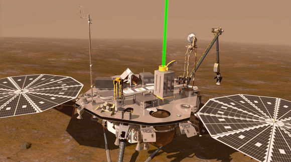
Artists rendition of Phoenix on Mars. Credit: NASA/JPL
[/caption]
Starting today, the Mars Odyssey orbiter will be listening once again for the Phoenix Mars Lander, lending an ear to hear if Phoenix has come back to life. Until May 21,Odyssey will listen for a signal from Phoenix during 61 flights over the lander’s site on Mars’ northern arctic region. Earlier attempts to detect a transmission from the lander — totaling 150 overflights in January, February and April – were not successful.
NASA decided to add another round of listening sessions that weren’t originally scheduled.
“To be thorough, we decided to conduct this final session around the time of the summer solstice, during the best thermal and power conditions for Phoenix,” said Chad Edwards, chief telecommunications engineer for the Mars Exploration Program at NASA’s Jet Propulsion Laboratory.
Phoenix quit communicating with Earth in November, 2008, and since that time endured a long and fierce Mars winter, where it was likely encased in CO2 ice in temperatures under -150 C. The solar arrays may have cracked and fallen off the vehicle, and the electronics probably became brittle and broke in the severe cold, so the wiring boards probably are nonfunctional.
Phoenix worked superbly for five months before reduced sunlight caused energy to become insufficient to keep the lander functioning. The solar-powered robot was not designed to survive through the dark and cold conditions of a Martian arctic winter.
Northern Mars experienced its maximum-sunshine day, the summer solstice, on May 12 (Eastern Time; May 13, Universal Time), so the sun will be higher in the sky above Phoenix during the fourth listening campaign than during any of the prior ones. Still, expectations of hearing from the lander remain low.
But nobody is ready to give up just yet.
Mars Express' view of Meridiani Planum. Credits: ESA/DLR/FU Berlin (G. Neukum)
[/caption]
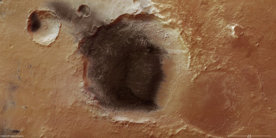
Earth isn’t the only place we’re seeing volcanic ash these days. New high resolution color images from ESA’s Mars Express of Meridiani Planum on Mars – the Opportunity rover’s neighborhood — shows evidence of volcanic ash in a small impact crater that is about 50 km wide. The wind-blown dark material also provides clues to the prevailing wind direction in this region of Mars. These images are stunning, especially in the large hi-resolution versions, so click on each image to see Mars up close and personal.
Perspective view of Meridiani Planum. Credits: ESA/DLR/FU Berlin (G. Neukum)
Mars is only about one-half the size of Earth, but yet has several volcanoes larger than anything we have on our home planet. The most massive volcanoes are located on huge uplifts or domes in the Tharsis and Elysium regions of Mars. Meridiani Planum lies close to Tharsis, and is a large plain at the northern edge of the southern highlands of Mars.
Poking through the dark covering are small mounds, probably made of harder, more resistant material. The softer material around them has been eroded and blown out of the crater by north-easterly winds and now lies outside the crater, forming dark streaks at the bottom left of the image.
This dark crater is close to Mars’ equator, and early on this area was chosen as a central reference point for Mars’ geographical coordinate system, so the martian prime meridian runs right through here. Hence the name “Meridiani.”
Meridiani Planum extends 127 km by 63 km and covers an area of roughly 8000 sq km
Three craters stretch across Meridiani Planum. Credits: ESA/DLR/FU Berlin (G. Neukum)
Three craters stretch across Meridiani Planum, as seen in this image. The nearest is an old crater, almost worn away. It is 34 km across. The second is covered in dark material, most likely a substance resembling volcanic ash. It is 50 km wide. The third crater, more distant, is smaller at 15 km wide. Again it possesses a dark floor, perhaps because material from the largest crater has been blown out by the wind and has settled in the smallest one.
The image below gives a broader perspective of the area. The color images were actually taken in 2005 and were just recently released by ESA.
Meridiani Planum at the northern edge of the southern highlands of Mars. The region lies at about 2°N/352°E . Credits: ESA/DLR/FU Berlin (G. Neukum)/MOLA


 and at the location of the Seminole outcrop. Spirit is currently located on the left side of Home Plate. Image width is ~1000 m. Image courtesy of NASA/UA/HiRISE using PSP_001513_1655_red image. After Arvidson et al. [2008]")


 and 2010. Credit: NASA/JPL/U of Arizona")


")
")
/MOLA")