Opportunity's view of the far-off rim of Endeavour Crater. Credit: NASA/JPL-Caltech/Cornell University
[/caption]
Back in September of 2008, Mars Exploration Rover Principal Investigator Steve Squyres announced the Opportunity rover would head out to a large, faraway crater named Endeavour, and Squyres said he hoped to one day see the view from the rim. Well, Oppy has now provided an improved view OF the rim: off in the distance in the image above are the “Endeavour Hills,” the mounds which surround the perimeter of the crater, about 13 km (8 miles) away, along with the rim of an even more distant crater, Iazu, on the right.
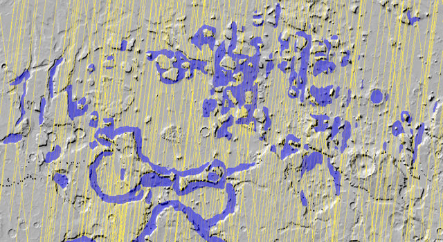
As the crow flies, Endeavour is about 12 km away from Oppy’s starting point in 2008, Victoria Crater. But while the intrepid rover has already traveled 7 km towards Endeavour, it still has 12 km to go, as the route chosen to avoid potentially hazardous dune fields is more like 19km, as presently charted, said Guy Webster at JPL. You can see an example of Opportunity’s circuitous driving below.
Opportunity's tracks show how the rover avoided driving through potentially dangerous sand dunes. Credit: NASA/JPL/U of AZ
The original target timing for Opportunity reaching Endeavour was about two years, but since the science team has had the rover spend several weeks stopping at interesting targets of study along the way, the rover will definitely not make it to Endeavour by September 2010. It might take another year, or even two.
Additionally, it is now winter on Mars, and according to A.S.J. Rayl’s Rover Update from the Planetary Society, Opportunity is now roving for only about 30 minutes at a time, which enables it to cover only 30-to-50 meters on a drive sol. And, the rover is also taking Martian days off to re-charge its batteries. Record cold temps this winter (down to -37 C) on Mars is slowing the aging rover.
But back in March Oppy reached 20 kilometers (12.43 miles) of total driving in its 74 months on Mars. Pretty amazing for a piece of hardware that was supposed to last six months and drive about 600 meters. Later this month, Oppy will surpass the Viking Lander 1’s record of 6 years and 116 days to become the longest-lived robot on Mars. The Spirit rover has already surpassed that record, but it is unknown if the rover is only hibernating and we’ll hear from it when it warms up again, or if Spirit is no longer with us (sniff!).
Endeavour Crater is 21 kilometers (13 miles) in diameter, which is about 25 times wider than Victoria crater. The view in the top image is an area about 140 kilometers (about 90 miles) wide. Orbital view of Opportunity's location from THEMIS. mage Credit: NASA/JPL-Caltech/Arizona State University
This view shows a top-down look at the area from orbit, and is a mosaic of daytime infrared images taken by the Thermal Emission Imaging System (THEMIS) camera on NASA’s Mars Odyssey orbiter.
Additionally, a new gif “movie” was released this week showing how Oppy emerged from Victoria crater about a year and a half ago. Click here to see it.
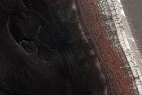
A new image from the HiRISE camera on MRO showing mounds of south polar layered deposits. Credit: NASA/JPL/University of Arizona
[/caption]
With Mars seemingly the destination of choice in NASA’s future, researchers are taking a look at what kinds of things we want to bring with us when we go to Mars. But also, just as important is what we don’t want to take with us. A new study by the University of Central Florida reveals that bacteria common to spacecraft may be able to survive the harsh environment of Mars long enough to inadvertently contaminate the Red Planet with terrestrial life. So, if we do find life on Mars, the question might be: is it them, or is it us?
The research team replicated Mars-like conditions, such as a very dry environment, low barometric pressure, cold temperatures and intense UV radiation. They exposed one of our favorite bacteria, E. coli (Escherichia coli) – which is a potential spacecraft contaminant– to these conditions for a week, and found it likely would survive but not grow on the surface of Mars if it were shielded from UV irradiation, such as in nooks and crannies in a spacecraft, or even if it was covered by thin layers of dust.
“If long-term microbial survival is possible on Mars, then past and future explorations of Mars may provide the microbial inoculum (biological materials) for seeding Mars with terrestrial life,” said the researchers. “Thus, a diversity of microbial species should be studied to characterize their potential for long term survival on Mars.”
Even though NASA and other space agencies do sterilize spacecraft in an effort to reduce the chance of contamination to other bodies in our solar system, recent studies have shown that microbial species are likely still hitching a ride. And in what might be a more-harm-than-good scenario, the sterile nature of spacecraft assembly facilities ensures that only the most resilient species survive, including acinetobacter, bacillus, escherichia, staphylococcus and streptococcus. So we’re likely sending the worst of the worst kinds of bacteria, at least by human standards.
This research was published in the April 2010 issue of the journal Applied and Environmental Microbiology.
Spirit rover, as seen by HiRISE on Feb. 15, 2010. Crop and colorization by Stuart Atkinson, image credit: NASA/JPL, U of AZ
[/caption]
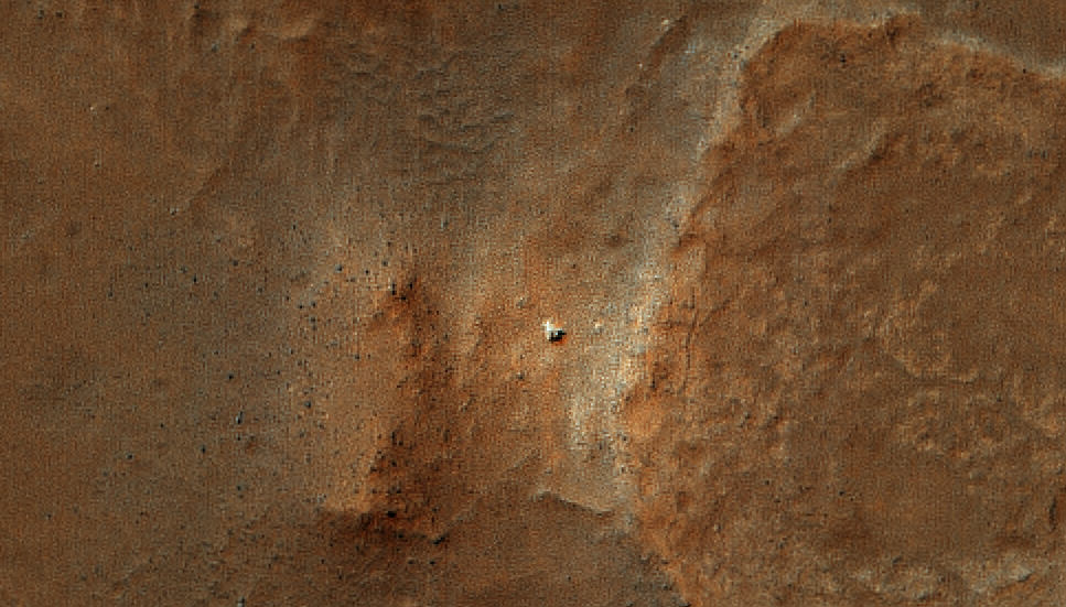
The HiRISE team released some new images on Wednesday — one of which was another incredible avalanche image. But then there was another shot of Gusev Crater, the home of the Spirit rover. It was a wide shot of the entire region (you can see it below), and visible are the Columbia Hills, and if you look real close you can see the “Home Plate” region where Spirit sits. Our friend Stu Atkinson took a real close look and found Spirit sitting all alone –but very visible in this wonderfully amazing zoom-in closeup! (Click the image for access to a larger version). Stu also colorized it to show almost intricate detail of Spirit’s solar panels. The image was taken on Feb. 15, 2010, and she looks great! She’s in her current stationary position, and even though this image is from before she went into hibernation, it’s great to know she’s still sitting there, waiting for warmer days. “Hang in there rover, hang in there…” Stu said on Twitter, which echoes all our sentiments. Awww, Spirit….
Thanks to Stu and HiRISE for keeping our hopes alive!
The Spirit rover landing region. Credit: NASA/JPL/University of Arizona
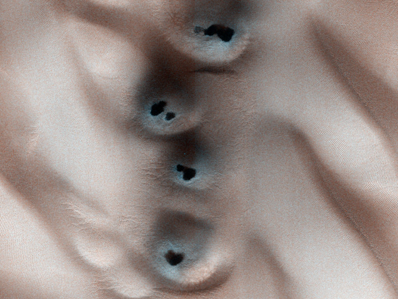
A shot monitoring the original site of active frost-dust avalanches (ESP_016173_2640) Credit: NASA/JPL/University of Arizona
[/caption]
In 2008, the HiRISE camera on the Mars Reconnaissance Orbiter was monitoring a certain region on Mars for changes in frost patterns as spring progressed, and serendipitously captured an avalanche in action. This year, the HiRISE team has been on the lookout, ready to capture more avalanches as spring approaches in Mars’ northern hemisphere. They’ve been successful — and how! This awesome shot was captured on January 27, 2010 of a steep cliff in the northern polar region of Mars, and shows at least three isolated clouds of particles falling from the cliff. The HiRISE teams says that these clouds, rolling or hovering close to the ground likely reach up tens of meters high (up to 180 feet)! The avalanches are a result of carbon-dioxide frost that clings to the scarp in the darkness of winter, and when sunlight hits them in the spring they loosen up and fall. The cliff, approximately 700 meters (2000 feet) high is made up of layers of water ice with varying dust content, roughly similar to the polar ice caps on Earth. But wait, there’s more! Yes, it’s avalanche season on Mars!
Another avalanche seen earlier in 2010. Credit: NASA/JPL/University of Arizona
Here’s another avalanche captured on January 12, 2010, and below, the HiRISE camera was trained on the same site that the original avalanche was captured back in 2008.
A shot monitoring the original site of active frost-dust avalanches (ESP_016173_2640) Credit: NASA/JPL/University of Arizona
The HiRISE teams says that by looking at all of the individual instances of avalanches from all of the images will also allow them to piece together a sequence of snaphots of the whole avalanche process, from beginning (a stream of material falling down the cliff face) to end (lingering puffy clouds). Patrick Russell writes:
Based on this year’s observations, these events happen mostly in the middle of spring, roughly equivalent to April to early May on Earth. And, they are indeed more widespread than just this one scarp. All together, it seems this is a regular spring process at Mars’ north pole that may be expected every year – avalanche season! This information, in conjunction with the results of numerical modeling of the behavior of the materials involved, will help us find out what is causing these dramatic events.
How do the folks from UnmannedSpaceflight do it?!! They keep surpassing themselves with every new flyover video! We’ve posted some Mars flyover videos before, created by UMSF founder Doug Ellison. Now, colleague Adrian Lark — who has been working on creating animations and enhanced images with data from the Mars missions for several years — has produced new features on the videos. This latest, which flies you around the scarp surrounding Olympus Mons has speed and height information as well as a context map included on the video. “The data I am using is generated from the HiRISE camera onboard the Mars Reconnaissance Orbiter,” Adrian told me. “The elevation data has a spatial resolution of 1 meter and the image data has a spatial resolution of 25 centimeters. There is no vertical exaggeration in any of the videos.”
Also, Adrian has experimented with You Tube’s stereoscopic 3-D player, providing a 3-D experience of flying through Candor Chasma. IMAX, watchout! You’ve got competition!
Details from the Ascraeus channel (red), meandering across the surface of Mars. The insets in the black boxes show close-ups of some of the structures that lava can form: (left) branched channels, (middle) a snaking channel and (right) rootless vents; the rootless vents are also marked by yellow spots on the main image. Credit: Jacob Bleacher
[/caption]
Images of Mars taken from orbit show a massive system of riverbeds and canyons etched by water. Or maybe not. A new study of one channel shows that it was formed by lava flow and not water, and the results make “a strong case that fluid lava can produce channels that look very much like water-generated features,” said Jim Zimbelman from the Smithsonian Institution in Washington, one of the researchers. “So, we should not jump to a water-related conclusion when we see such channels on other planets.”
Whether channels on Mars were formed by water or by lava has been debated for years and the outcome is thought to influence the likelihood of finding life there. Images from various Mars orbiters reveal details resembling the erosion of soil by water: terracing of channel walls, formation of small islands in a channel, hanging channels that dead-end and braided channels that branch off and then reconnect to the main branch. “These are thought to be clear evidence of fluvial [water-based] erosion on Mars,” said Jacob Bleacher from Goddard Spaceflight Center, who presented the results at the Lunar and Planetary Science Conference last week.
Lava flow usually creates big, open channels, such as the ones commonly seen in Hawaii. But detailed looks at both channels on Mars and in Hawaii shed a whole new light on the formation of channels and other features on Mars.
The research team carried out a careful study of a single channel on the southwest flank of Mars’ Ascraeus Mons volcano, one of the three clustered volcanoes collectively called the Tharsis Montes. To piece together images covering more than 270 kilometers (~168 miles) of this channel, the team relied on high-resolution pictures from three cameras—the Thermal Emission Imaging System (THEMIS), the Context Imager (CTX) and the High/Super Resolution Stereo Color (HRSC) imager—as well as earlier data from the Mars Orbiter Laser Altimeter (MOLA). These data gave a much more detailed view of the surface than previously available.
Because the fluid that formed this and other Ascraeus Mons channels is long-gone, its identity has been hard to deduce, but the visual clues at the source of the channel seem to point to water. These clues include small islands, secondary channels that branch off and rejoin the main one and eroded bars on the insides of the curves of the channels. The Tharsis region of Mars, including the three volcanoes of Tharsis Montes (Arsia, Pavonis and Ascraeus Mons), as well as Olympic Mons in the upper left corner. Credit: NASA/Jet Propulsion Lab
But at the channel’s other end, an area not clearly seen before, the team found a ridge that appears to have lava flows coming out of it. In some areas, “the channel is actually roofed over, as if it were a lava tube, and lined up along this, we see several rootless vents,” or openings where lava is forced out of the tube and creates small structures, he explains. These types of features don’t form in water-carved channels, he notes. Bleacher argues that having one end of the channel formed by water and the other end by lava is an “exotic” combination. More likely, he thinks, the entire channel was formed by lava.
To find out what kinds of features lava can produce, Bleacher, Zimbelman and W. Brent Garry examined the 51-kilometer (~32 mile) lava flow from the 1859 eruption of Mauna Loa on the Big Island of Hawaii. Their main focus was an island nearly a kilometer long in the middle of the channel; Bleacher says this is much larger than islands typically identified within lava flows. To survey the island, the team used differential GPS, which provides location information to within about 3 to 5 centimeters (1.1 to 1.9 inches), rather than the roughly 3 to 5 meters (9.8 to 16.4 feet) that a car’s GPS can offer.
“We found terraced walls on the insides of these channels, channels that go out and just disappear, channels that cut back into the main one, and vertical walls 9 meters (~29 feet) high,” Bleacher says. “So, right here, in something that we know was formed only by flowing lava, we found most of the features that were considered to be diagnostic of water-carved channels on Mars.”
Further evidence that such features could be created by lava flows came from the examination of a detailed image of channels from the Mare Imbrium, a dark patch on the moon that is actually a large crater filled with ancient lava rock. In this image, too, the researchers found channels with terraced walls and branching secondary channels.
The conclusion that lava probably made the channel on Mars “not only has implications for the geological evolution of the Ascraeus Mons but also the whole Tharsis Bulge [volcanic region],” says Andy de Wet, a co-author at Franklin & Marshall College, Lancaster, Penn. “It may also have some implications for the supposed widespread involvement of water in the geological evolution of Mars.”
A radar on NASA's Mars Reconnaissance Orbiter has detected widespread deposits of glacial ice in the mid-latitudes of Mars.NASA/JPL-Caltech/ASI/University of Rome/Southwest Research Institute
[/caption]
Sure, it’s big news the Moon has water ice on the north pole, but Mars is loaded! A new extensive radar mapping of the middle-latitude region of northern Mars shows that thick masses of buried ice are quite common beneath the surface. The Mars Reconnaissance Orbiter’s Shallow Radar instrument has detected subsurface ice deposits that extend for hundreds of kilometers in the rugged region called Deuteronilus Mensae, about halfway from the equator to the Martian north pole. “We have mapped the whole area with a high density of coverage,” said Jeffrey Plaut from JPL. “These are not isolated features. In this area, the radar is detecting thick subsurface ice in many locations.”
The Shallow Radar instrument has been charting the locations of these hidden glaciers and ice-filled valleys, finding that the most common locations are around the bases of mesas and scarps, and confined within valleys or craters. After obtaining more than 250 observations of the study area, which is about the size of California, the science team is beginning to understand how these deposits may have been left as remnants when regional ice sheets retreated.
“The hypothesis is the whole area was covered with an ice sheet during a different climate period, and when the climate dried out,” Plaut said, “these deposits remained only where they had been covered by a layer of debris protecting the ice from the atmosphere.”
These buried masses of ice are a significant fraction of the known non-polar ice on Mars. The ice could contain a record of environmental conditions at the time of its deposition and flow, making the ice masses an intriguing possible target for a future mission with digging capability.
MRO will continue mapping the area to provide more insight into the buried ice.
Phobos from Mars Express. Credit: ESA/DLR/FU Berlin (G. Neukum).
[/caption]
Mars Express will skim over the surface of Mars’ largest moon on Wednesday, making the closest flyby of Phobos by any spacecraft. Passing at just 67 km above the surface, precise radio tracking will allow researchers to virtually peer inside the mysterious moon. You can follow the flyby in “real time,” — allowing for the current 6 minute and 30 second light time delay from Mars (13 minutes round trip) – on the Mars Express blog. The flyby will take place on March 3, at 20:55 GMT.
The straight-line distance between Mars Express and Earth is now about 116 million km.
Flying by at such close range, Mars Express will be pulled ‘off-course’ by the gravitational field of Phobos. This will amount to no more than a few millimeters every second and will not affect the mission in any way. However, to the tracking teams on Earth, it will allow a unique look inside the moon to see how its mass is distributed throughout. Phobos’ shape is 27 km × 22 km × 19 km, and has a mass of 1.072 x 10¹⁶ kg, or about one-billionth the mass of Earth.
To make the very sensitive measurements of Phobos’ interior, all the data signals from the spacecraft will be turned off. The only thing that the ground stations will listen out for is the ‘carrier signal’ – the pure radio signal that is normally modulated to carry data.
With no data on the carrier signal, the only thing that can modulate the signal is any change in its frequency caused by Phobos tugging the spacecraft. The changes will amount to variations of just one part in a trillion, and are a manifestation of the Doppler effect – the same effect that causes an ambulance siren to change pitch as it zooms past.
Two dress rehearsals for this exacting operation have already taken place, allowing ground station personnel and spacecraft controllers to practice.
Originally, the closest flyby was going to only 50 km above the surface, but a slight ‘over performance’ during a maneuver last week had put the spacecraft on a trajectory that included an occultation by Phobos. This meant that Mars Express would pass behind Phobos as seen from Earth. As this would jeopardize the tracking measurements, it was decided to perform another maneuver to position the flyby at a slightly higher altitude than originally planned. An illustration showing the ESA's Mars Express mission. Credit: ESA/Medialab)
Mars Express will zoom past Phobos seven more times after Wednesday’s closest approach. The first planned High Resolution Stereo Camera (HRSC) observations will be on March 7, when the spacecraft will be at 107 km altitude above Phobos.
In addition to the tracking experiment, known as MaRS for Mars Radio Science, the MARSIS radar has already been probing the subsurface of Phobos with radar beams. “We have performed a preliminary processing of the data and the Phobos signature is evident in almost all the data set,” says Andrea Cicchetti, Italian Institute of Physics of Interplanetary Space, Rome, and one of the MARSIS team.
A single-image photoclinometric 3D reconstruction of the Mars avalanche from HiRISE. Image data: NASA/JPL/UA; 3D model: Bernhard Braun
[/caption]
Remember the amazing image of an avalanche on Mars back in 2008, captured by the HiRISE camera on the Mars Reconnaissance Orbiter? Bernhard Braun from UnmannedSpaceflight.com has now created several different 3-D views of the event, providing never-seen-before, ground-level observations by using special software he developed that can create three dimensional images from one 2-dimensional picture. Normally, to create a 3-D image you need at least two images, or you have to combine images with data from an instrument such as a laser altimeter. But Braun’s single-image photoclinometric 3D reconstruction algorithm, also known as “shape from shading” allows the shape of three dimensional objects to be recovered from shading in a two-dimensional image. Braun told Universe Today that since developing the software, one of the areas he has wanted to “visit from the ground” is the famous dust avalanche caught live in action by HiRISE. His images provide an entirely new — and stunning — view of Mars.
A single-image photoclinometric 3D reconstruction of the Mars avalanche from HiRISE. Image data: NASA/JPL/UA; 3D model: Bernhard Braun
Braun said that the software is useful to look at various areas of interest, in particular where we have no other (i.e stereo-imaging based) detailed 3D reconstructions yet. Previously, we’ve shown 3-D movies on Universe Today that Doug Ellision and others from UnmannedSpaceflight.com have created from HiRISE DEMs (Digitial Elevation Models) which are a grid, or raster file describing elevation values at regularly spaced points, or posts. HiRISE DEMs are made from two high-resolution images of the same area, taken from different look angles by the spacecraft. The HiRISE folks say that creating a DEM is complicated and involves sophisticated software and a lot of time, both computing time and man-hours.
But Braun’s software (although it took him quite some time to develop) allows for a moderate processing time, about 15 minutes per medium-resolution image, using about 2 gigabytes of memory. Also, no texturing or additional coloring/shading was applied when rendering the surface, and every detail visible is real 3D down to the pixel-level.
But, Braun doesn’t think his method is in any way “superior” to the HiRISE team’s efforts.
“Quite to the contrary,” he told me via email. “Traditionally, single-image shape-from-shading methods like the one that I developed, are considered to nicely complement the multi-image (stereo) methods because the weaknesses of one method (large scale distortions in single-image-methods vs. less detail resolution in multi-image methods ) is the strength of the other. Also, the official HiRISE DEMs are generally more accurate at exactly reproducing absolute terrain heights (also using altimeter-based calibration), which is important for scientific usage, whereas my DEMs are less well calibrated because they are mainly intended for visualization purposes.”
The main advantage of the single-image method is that it can be used on almost arbitrary images of areas where there isn’t 3D coverage yet, such as capturing an event like an avalanche.
“In a way, it opens the door to an entirely new view of large existing 2D-only data sets, Braun said. “For example, currently I am working on an extension of the method to radar images for hi-resolution 3D reconstructions of the highest-resolution Venus Magellan data sets.”
Braun’s software method could be considered more of an art form.
“I view my software and algorithms not so much as a scientific measuring instrument,” Braun told me in an email, “but more as a tool for visualization that leaves a bit of artistic license, a degree in freedom of interpretation i.e. the means for creating atmospheric images and it is those images that are the real “publishable end product” of the whole process. The algorithms and software are just the ‘painters brush and easel’ or the photographer’s virtual camera so to speak.” Another single-image photoclinometric 3D reconstruction of the Mars avalanche from HiRISE. Image data: NASA/JPL/UA; 3D model: Bernhard Braun
Emily Lakdawalla did a wonderful job of explaining the whys and hows of the entire process in the Planetary Society Blog: (go there if you’d like a more detailed description) “Imagine a crumpled piece of paper lit by a spotlight. Facets of the crumpled paper that are perpendicular to the spotlight will appear brightest; facets tilted away from the spotlight will appear dark. If you assume that everything in the picture reflects light in the same way, then you can tell by its albedo, or brightness, whether it is tilted toward or away from the light source. ” A Mars Avalanche, taken by NASAs HiRISE instrument on the Mars Reconnaisance Orbiter (Credit: NASA/HiRISE)
Above is the original image from HiRISE. When looking at these images, remember that this particular scarp on Mars is a high cliff over 700 m (2300 ft) tall and slopes at over 60 degrees. A mixture of ice, rock and dust can be seen, frozen in time, as it is plummeting down the slope, ejecting a plume of dust as the debris begins to settle on the gentle slope at the bottom of the cliff. The ejected cloud is approximately 180 meters across and extends about 190 meters beyond the base of the cliff.
Braun told us he is working on some new images which we hope to be able to share with you soon, and we extend our thanks to him for allowing us to post the avalanche images on Universe Today.
Follow this link to look at Braun’s entire gallery of wonderful color 3D renderings of the avalanche, derived from the originally published HiRISE image, rendered under various viewing positions and light source directions.
An illustration showing the ESA's Mars Express mission. Credit: ESA/Medialab)
Understanding the present-day Martian climate gives us insights into its past climate, which in turn provides a science-based context for answering questions about the possibility of life on ancient Mars.
Our understanding of Mars’ climate today is neatly packaged as climate models, which in turn provide powerful consistency checks – and sources of inspiration – for the climate models which describe anthropogenic global warming here on Earth.
But how can we work out what the climate on Mars is, today? A new, coordinated observation campaign to measure ozone in the Martian atmosphere gives us, the interested public, our own window into just how painstaking – yet exciting – the scientific grunt work can be.
[/caption]
The Martian atmosphere has played a key role in shaping the planet’s history and surface. Observations of the key atmospheric components are essential for the development of accurate models of the Martian climate. These in turn are needed to better understand if climate conditions in the past may have supported liquid water, and for optimizing the design of future surface-based assets at Mars.
Ozone is an important tracer of photochemical processes in the atmosphere of Mars. Its abundance, which can be derived from the molecule’s characteristic absorption spectroscopy features in spectra of the atmosphere, is intricately linked to that of other constituents and it is an important indicator of atmospheric chemistry. To test predictions by current models of photochemical processes and general atmospheric circulation patterns, observations of spatial and temporal ozone variations are required.
The Spectroscopy for Investigation of Characteristics of the Atmosphere of Mars (SPICAM) instrument on Mars Express has been measuring ozone abundances in the Martian atmosphere since 2003, gradually building up a global picture as the spacecraft orbits the planet.
These measurements can be complemented by ground-based observations taken at different times and probing different sites on Mars, thereby extending the spatial and temporal coverage of the SPICAM measurements. To quantitatively link the ground-based observations with those by Mars Express, coordinated campaigns are set up to obtain simultaneous measurements.
Infrared heterodyne spectroscopy, such as that provided by the Heterodyne Instrument for Planetary Wind and Composition (HIPWAC), provides the only direct access to ozone on Mars with ground-based telescopes; the very high spectral resolving power (greater than 1 million) allows Martian ozone spectral features to be resolved when they are Doppler shifted away from ozone lines of terrestrial origin.
A coordinated campaign to measure ozone in the atmosphere of Mars, using SPICAM and HIPWAC, has been ongoing since 2006. The most recent element of this campaign was a series of ground-based observations using HIPWAC on the NASA Infrared Telescope Facility (IRTF) on Mauna Kea in Hawai’i. These were obtained between 8 and 11 December 2009 by a team of astronomers led by Kelly Fast from the Planetary Systems Laboratory, at NASA’s Goddard Space Flight Center (GSFC), in the USA. Credit: Kelly Fast About the image: HIPWAC spectrum of Mars’ atmosphere over a location on Martian latitude 40°N; acquired on 11 December 2009 during an observation campaign with the IRTF 3 m telescope in Hawai’i. This unprocessed spectrum displays features of ozone and carbon dioxide from Mars, as well as ozone in the Earth’s atmosphere through which the observation was made. Processing techniques will model and remove the terrestrial contribution from the spectrum and determine the amount of ozone at this northern position on Mars.
The observations had been coordinated in advance with the Mars Express science operations team, to ensure overlap with ozone measurements made in this same period with SPICAM.
The main goal of the December 2009 campaign was to confirm that observations made with SPICAM (which measures the broad ozone absorption spectra feature centered at around 250 nm) and HIPWAC (which detects and measures ozone absorption features at 9.7 μm) retrieve the same total ozone abundances, despite being performed at two different parts of the electromagnetic spectrum and having different sensitivities to the ozone profile. A similar campaign in 2008, had largely validated the consistency of the ozone measurement results obtained with SPICAM and the HIPWAC instrument.
The weather conditions and the seeing were very good at the IRTF site during the December 2009 campaign, which allowed for good quality spectra to be obtained with the HIPWAC instrument.
Kelly and her colleagues gathered ozone measurements for a number of locations on Mars, both in the planet’s northern and southern hemisphere. During this four-day campaign the SPICAM observations were limited to the northern hemisphere. Several HIPWAC measurements were simultaneous with observations by SPICAM allowing a direct comparison. Other HIPWAC measurements were made close in time to SPICAM orbital passes that occurred outside of the ground-based telescope observations and will also be used for comparison.
The team also performed measurements of the ozone abundance over the Syrtis Major region, which will help to constrain photochemical models in this region.
Analysis of the data from this recent campaign is ongoing, with another follow-up campaign of coordinated HIPWAC and SPICAM observations already scheduled for March this year.
Putting the compatibility of the data from these two instruments on a firm base will support combining the ground-based infrared measurements with the SPICAM ultraviolet measurements in testing the photochemical models of the Martian atmosphere. The extended coverage obtained by combining these datasets helps to more accurately test predictions by atmospheric models.
It will also quantitatively link the SPICAM observations to longer-term measurements made with the HIPWAC instrument and its predecessor IRHS (the Infrared Heterodyne Spectrometer) that go back to 1988. This will support the study of the long-term behavior of ozone and associated chemistry in the atmosphere of Mars on a timescale longer than the current missions to Mars.


")


")
