This image shows a river that sprang from a past glacier from an unnamed crater in Mars’ middle latitudes. Credit: NASA/JPL/MSSS
[/caption]
No sooner do we post one article about water on Mars when it’s time for another. Planetary scientists have uncovered telltale signs of water on Mars — frozen and liquid — in the earliest period of the Red Planet’s history. They found evidence of running water that sprang from glaciers throughout the Martian middle latitudes as recently as the Amazonian epoch, several hundred million years ago. These glaciofluvial valleys were, in essence, tributaries of water created when enough sunlight reached the glaciers to melt a thin layer on the surface. This led to “limited surface melting” that formed channels that ran for several kilometers and could be more than 150 feet wide.
The finding is “more than ‘Yes, we found water,’” said Caleb Fassett from Brown University, who along with Brown research analyst James Dickson, professor James Head III, and geologists from Boston University and Portland State University published a paper in Icarus. “What we see now is there’s this complex history of different environments where water is being formed.”
The team analyzed 15,000 images snapped by the Context Camera (CTX) aboard the Mars Reconnaissance Orbiter to compile the first survey of glaciofluvial valleys on Mars. The survey was sparked by a glaciofluvial valley that Dickson, Fassett, and Head spotted within the Lyot crater, located in the planet’s middle latitudes. The team, in a paper last year in Geophysical Research Letters, dated that meltwater-inspired feature to the Amazonian.
In his survey, Fassett found dozens of other Amazonian-era ice deposits that spawned supraglacial and proglacial valleys, most of them located on the interior and exterior of craters in Mars’ midlatitude belt. “The youthfulness (of the features) is surprising,” he said. “We think of [post-Noachian] Mars as really, really cold and really, really dry, so the fact that these exist, in those kinds of conditions, is changing how we view the history of water on the planet.”
What makes the finding even more intriguing is that the Brown planetary scientists can study what they believe are similar conditions on Earth. Teams from Brown and Boston University have visited the Antarctic Dry Valleys for years, where the surfaces of glaciers melt during the austral summer, sparking enough meltwater to carve a channel. The team will return to the Dry Valleys later this year to continue the study of this microclimate.
“It’s sort of crazy,” said Dickson, a member of the Brown team who stayed in the Dry Valleys for three months last year. “You’re freezing cold and there’s glacial ice everywhere, and it gets just warm enough that you get a river.”
Fassett plans to search for more glaciofluvial valleys as more images come from the CTX, which has mapped roughly 40 percent of the planet.
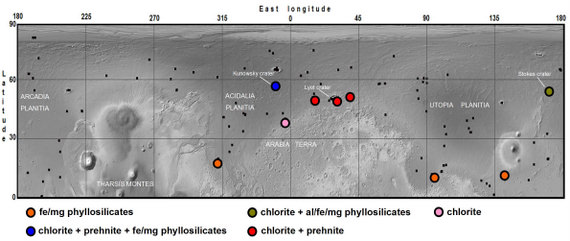
Locations of nine exposures of hydrated silicate in northern plain craters, shown on a Mars Orbiter Laser Altimeter shaded relief map. Black squares indicate sites investigated with CRISM that did not yield detections. Image courtesy of Science/AAAS.
By looking at the mineralogy deep inside craters on Mars’ northern plains and comparing it to the makeup of regions in the southern hemisphere, scientists have found that widespread liquid water likely altered the majority of Red Planet’s crust about 4 billion years ago. However, the new findings do not support other recent studies that suggest a giant ocean covered Mars’ northern highlands.
Using the Mars Express OMEGA instrument and the Mars Reconnaissance Orbiter’s CRISM instrument, John Carter from Bibring at Université Paris in Orsay, France along with a group of scientists from France and the US, investigated large craters and found minerals which could have only formed in the presence of water. “We’ve detected hydrated minerals in about 10 of these craters,” Carter told Universe Today, “and we conclude that the ancient crust was altered in a similar way both in the south and in the north, in a very early environment which was much warmer and wetter than today’s.”
Carter added that in terms of Mars’ water history, this means liquid water existed near and on the surface of early Mars on a planetary scale, and is not restricted to select areas of the southern highlands.
Mars has dichotomy between north and south, (read our earlier article “The Two Faces of Mars Explained) so while the south is ancient, heavily cratered and high up, the north is smooth, with low-lying plains. It also is much younger and less cratered than the south. This is due to a volcanic mantling processes which filled up part of the lowlands and thus erased any former structures.
HRSC observation of Kunowsky crater, centered at 350.3°E, 56.8°N. (B) CTX close-up (image B01_009932_2370). CRISM mineral maps from observations FRT0000BAD4 and FRT0000C63C are overlaid in red (smectites or chlorite-prehnite) and green (olivine). The white dashed lines indicate the boundaries of the two adjacent observations. (C) HiRISE close-up (image PSP006860_2370) overlain by CRISM mineral maps. No HiRISE data are available over the chlorite-prehnite unit. Image courtesy of Science/AAAS
Carter and his team began their work based on studies of hundreds of sites in the southern hemisphere of Mars which were found to have hydrated minerals which formed on or near the surface some 4 billion ago in a wet and warm environment. While today Mars does not and cannot sustain liquid water on its surface, the scientists knew that a rather weak hydrological system had existed in the southern hemisphere, based on previous geological and morphological evidence.
If minerals in Mars’ northern hemisphere had formed in the presence of water, those minerals would have been buried by the widespread and intense lava flow which happened about 3 billion years ago, resurfacing that region of the planet. But looking into impact craters provides a window into Mars’ past by penetrating down through the lava flow, as well as showering chunks of the underlying crust across the nearby surface.
Carter said the data from OMEGA and CRISM show the mineral assemblages within and around these craters in the north as are very similar to what is seen in the southern ancient highlands, which includes phyllosilicates or other hydrated silicates.
“Our work broadens our view of liquid water on ancient Mars,” Carter said in an email, “spreading it to most of the planet, and may also provide a constraint on the timing of the northern hemisphere alteration with respect to its formation.”
Another conclusion, Carter said, is that these detections may be a constraint on when Mars could have possibly been conducive to the formation of life. “The main scenario which explains the dichotomy is that of an oblique impact between Mars and a fair sized celestial body, thus obliterating and re-melting a great deal of the northern hemisphere of Mars. Such an impact would surely have destroyed any pre-existing hydrated minerals at the depths at which we’re seeing them or we think they come from. Thus the water stability era likely took place after this giant impact, and did not last long (several hundred million years at most). Thus our work may provide a lower limit on this era.”
CTX–HRSC mosaic of Stokes crater, centered at 171.35°E, 55.56°N. (B) CTX closeup (image P20_008686_2356). CRISM mineral maps from observation FRT0000ADA4 are overlain in color. The white dashed lines indicate the boundaries of the CRISM observation. (C) HiRISE close-up (image PSP_009332_2360) of the Al-phyllosilicate “montmorillonite”-bearing unit. The sources of the material are the bright outcrops near the scarp summit (right), whereas the light-toned unit (left) is material transported downslope. (D) HiRISE close-up (image PSP_009332_2360) showing outcrops of olivine, Fe/Mg-, and Al-phyllosilicates in close spatial association. Image courtesy of Science/AAAS
Concerning the giant ocean scenario for the northern highlands, on which a paper was published just last week, Carter said his team’s findings show evidence against those circumstances. “Previous work by a number of teams have actually shown the unlikelihood of a giant northern ocean on Mars younger than 3 billion years as hypothesized by several researchers,” he said. “There is no morphological nor mineralogical evidence for such an ocean. In our 10 or so craters of the northern plains of Mars where we found hydrated minerals, we also found mafic minerals such as olivine. This olivine is almost ubiquitous in northern plain craters, and the vast majority of it is unaltered. Olivine is very readily altered by liquid water hence a giant ocean which would have submerged all these craters should have altered all the olivine, and this is seldom the case.”
Carter said that studying craters from orbit provides a bit of a challenge. “It is hard, for example, to distinguish rocks from orbit which may have been excavated by the impact or actually formed after the impact when the heat released and the existing water and/or ice interacted with the rock to form new minerals, creating hydrothermal environments. In our paper we put forward several reasons why an excavation scenario is favored to a post-impact hydrothermal scenario.”
But craters on Mars provide a better study of the past than craters on Earth, since craters may exist on Mars for billions of year without much degradation, while on Earth water, tectonics and plant growth all conspire to conceal and change craters. Carter said the excavated material on Mars will not be altered by the current ultra-dry, cool environment on the Red Planet.
This research new appears in the June 25, 2010 issue of Science.
Sources: AAAS/Science, email exchange with John Carter
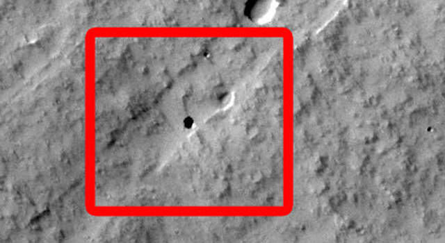
Sixteen seventh-graders at Evergreen Middle School in Cottonwood, Calif., found the Martian pit feature at the center of the superimposed red square in this image. Image Credit: NASA/JPL-Caltech/ASU
[/caption]
Tip number one on “How to impress your classmates:” Find a mysterious cave on Mars. A group of 16 seventh-graders at Evergreen Middle School in Cottonwood, California, USA found a dark pit that appears to be an opening to a cave on Mars. Dennis Mitchell’s science class were examining Martian lava tubes as their project in the Mars Student Imaging Program offered by NASA and Arizona State University, which takes advantage of the huge database of images taken by the Mars Odyssey spacecraft. The students found the skylight pit on the slope of an equatorial volcano named Pavonis Mons, and it appears to be an entrance to an underground lava tube. Similar ‘cave skylight’ features have been found elsewhere on Mars, but this is the first seen on this volcano.
“The students developed a research project focused on finding the most common locations of lava tubes on Mars,” Mitchell said. “Do they occur most often near the summit of a volcano, on its flanks or the plains surrounding it?”
Mitchell said he and his students have been surprised how much interest there has been nation-wide in their discovery. “They were kind of shocked about the interest, and I think that they are just now starting to realize that they made a pretty neat discovery.”
The imaging program allows students in upper elementary grades through to college to participate in Mars research by having them develop a geological question to answer, and then directing the teams for the Mars-orbiting camera to take an image to answer their question. Since MSIP began in 2004, more than 50,000 students have participated.
Now, because of this find, the HiRISE high resolution camera on the Mars Reconnaissance Orbiter will take follow-up images of the pit to provide a better look at the object. HiRISE can image the surface at about 30 centimeters (12 inches) per pixel, which may allow a look inside the hole in the ground. This is part of the HiWISH program, where the public can submit suggestions to the science team for locations on Mars to the camera to image.
“It gives the students a good understanding of the way research is conducted and how that research can be important for the scientific community. This has been a wonderful experience,” Mitchell said.”
“Yeah it was a lot of fun because it wasn’t like any other science that we did, because we actually got to interact with real scientists instead of just people out of the book and stuff,” said 13-year-old Kody Rulofson, one of the students in Mitchell’s class.
Kody’s mother, Doni Rulofson said Kody and his twin brother Chase, also in the class, are inspired by the experience they had finding the cave. “They’re excited. They’re just beyond belief, they’re like, ‘we knew it was something really cool but we had no idea it was this much of an interest to NASA.'”
Odyssey has been orbiting the Red Planet since 2001, returning data and images of the Martian surface and providing relay communications service for Mars Rovers Spirit and Opportunity. Find out more about Odyssey here.
MRO has been in orbit since 2006, and has also amassed a huge database of images, which can be seen here.
Mars500 participant Diego Urbina (follow him on Twitter at @diegou) provides a tour inside the Mars500 facilities – see how the crew are living and working for the next 17 months in isolation. On June 3, 2010 Urbina and five fellow crewmates from Europe, Russia and China embarked on a 520-day mock mission to Mars, and are living in a crew module in a warehouse in Moscow. See our preview article here.
n illustration of what Mars might have looked like some 3.5 billion years ago when an ocean likely covered one-third of the planet’s surface, according to a new University of Colorado at Boulder study. (Illustration by University of Colorado)
[/caption]
Like rising waters from a flood, the evidence for past water on Mars — and large amounts of it – keep mounting. The latest study, which combined the analysis of water-related features including scores of delta deposits and thousands of river valleys with a look at the possibility of a global hydrosphere on early Mars, found that a vast ocean likely covered one-third of the surface of Mars some 3.5 billion years ago.
“Collectively, these results support the existing theories regarding the extent and formation time of an ancient ocean on Mars,” said Gaetano Di Achille and Brian Hynek from the Univesity of Colorado at Boulder, in their article in Nature Geoscience, “and imply the surface conditions during the time probably allowed the occurrence of a global and active hydrosphere integrating valley networks, deltas and a vast ocean as major components of an Earth-like hydrologic cycle.”
The idea of an ocean on Mars has been repeatedly proposed and challenged over the past two decades, and just last week, another study proposed lakes in the Hellas Basin region on Mars. This new study provides further support for the idea of a sustained sea on the Red Planet during the Noachian era more than 3 billion years ago.
More than half of the 52 river delta deposits identified by the CU researchers — each of which was fed by numerous river valleys — likely marked the boundaries of the proposed ocean, since all were at about the same elevation. Twenty-nine of the 52 deltas were connected either to the ancient Mars ocean or to the groundwater table of the ocean and to several large, adjacent lakes, Di Achille said.
The study is the first to integrate multiple data sets of deltas, valley networks and topography from a cadre of NASA and European Space Agency orbiting missions of Mars dating back to 2001, said Hynek. The study implies that ancient Mars probably had an Earth-like global hydrological cycle, including precipitation, runoff, cloud formation, and ice and groundwater accumulation.
Di Achille and Hynek used a geographic information system, or GIS, to map the Martian terrain and conclude the ocean likely would have covered about 36 percent of the planet and contained about 30 million cubic miles, or 124 million cubic kilometers, of water. The amount of water in the ancient ocean would have formed the equivalent of a 1,800-foot, or 550-meter-deep layer of water spread out over the entire planet.
The volume of the ancient Mars ocean would have been about 10 times less than the current volume of Earth’s oceans, Hynek said. Mars is slightly more than half the size of Earth.
The average elevation of the deltas on the edges of the proposed ocean was remarkably consistent around the whole planet, said Di Achille. In addition, the large, ancient lakes upslope from the ancient Mars ocean likely formed inside impact craters and would have been filled by the transport of groundwater between the lakes and the ancient sea, according to the researchers.
A second study headed by Hynek and involving CU-Boulder researcher Michael Beach of LASP and CU-Boulder doctoral student Monica Hoke being published in the Journal of Geophysical Research–Planets — which is a publication of the American Geophysical Union — detected roughly 40,000 river valleys on Mars. That is about four times the number of river valleys that have previously been identified by scientists, said Hynek.
The river valleys were the source of the sediment that was carried downstream and dumped into the deltas adjacent to the proposed ocean, said Hynek. “The abundance of these river valleys required a significant amount of precipitation,” he said. “This effectively puts a nail in the coffin regarding the presence of past rainfall on Mars.” Hynek said an ocean was likely required for the sustained precipitation.
“One of the main questions we would like to answer is where all of the water on Mars went,” said Di Achille. He said future Mars missions — including NASA’s $485 million Mars Atmosphere and Volatile Evolution mission, or MAVEN, which is being led by CU-Boulder and is slated to launch in 2013 — should help to answer such questions and provide new insights into the history of Martian water.
The river deltas on Mars are of high interest to planetary scientists because deltas on Earth rapidly bury organic carbon and other biomarkers of life and are a prime target for future exploration. Most astrobiologists believe any present indications of life on Mars will be discovered in the form of subterranean microorganisms.
“On Earth, deltas and lakes are excellent collectors and preservers of signs of past life,” said Di Achille. “If life ever arose on Mars, deltas may be the key to unlocking Mars’ biological past.”
Hynek said long-lived oceans may have provided an environment for microbial life to take hold on Mars.
Possible Phyllosilicates in Her Desher Vallis. Credit: NASA/JPL/University of Arizona
[/caption]
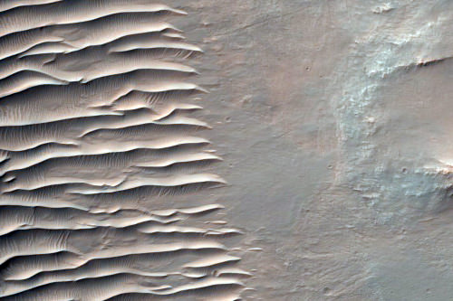
Mmmm, Mars. And lots of it, too! The team from one of our all-time favorite scientific instruments, the HiRISE camera on the Mars Reconnaissance Orbiter has just released a big batch of images taken from April 5 to May 6, 2010, and they are now available on NASA’s Planetary Data System and on the HiRISE website. This includes over six hundred recent observations of the Mars landscape as seen from orbit, including scenes of sinuous gullies, geometrical ridges, steep cliffs, or these unusual dunes, above, in Desher Vallis.
Each of the 629 new images cover an area of several square miles on Mars and reveals details as small as desks. Possible Cone Field in Phlegra Dorsa. Credit: NASA/JPL/University of Arizona
HiRISE is made of awesome, and is one of six instruments on MRO,which reached Mars in 2006.
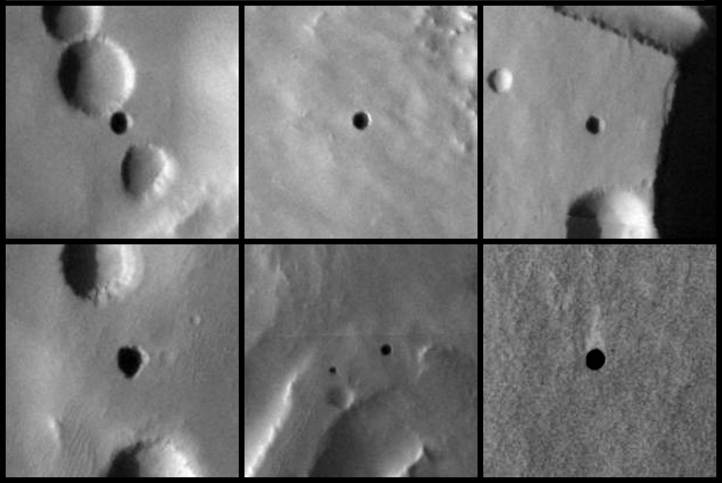
The circular black features in this 2007 figure are caves formed by the collapse of lava tubes on Mars. Image credit: NASA/JPL-Caltech/ASU/USGS
[/caption]
New results published in the journal Icarus suggest that caves on Mars may provide future astronauts with more than just shelter. In many locations, even far from the poles, the caves may actually trap water ice.
Ice caves are made of rock, but they contain ice year-round. (Not to be confused with glacier caves, which are caves made of ice!) Ice caves can be found on the Earth even where surface temperatures are above freezing for months at a time. This happens because cold winter air sinks into the cave and is trapped, but during the summer, the circulation in the cave shuts off: it is full of dense cold air so the warm air outside can’t get in.
Now, in a study led by Kaj Williams of NASA Ames, scientists have used simulations of the global climate and assumptions about the thermal properties of the surface to figure out where on Mars similar cold-trapping might occur. Their results show that a significant portion of the martian surface has the right conditions for ice to accumulate in caves.
Even more tantalizing, the huge volcanic provinces of Tharsis and Elysium look to be particularly good at accumulating ice. This is important because caves formed by collapsing lava tubes have been seen on the flanks of these volcanoes. Lava tube caves on Earth tend to have limited air circulation, making them good candidates for ice accumulation.
Astronauts on the surface of Mars will likely need to take cover underground to avoid the harsh radiation environment of the surface. Natural caves such as lava tubes have been suggested as ideal ready-made shelters for astronauts, and they are only looking better. Not only could ice caves provide water as a resource, the ice could preserve valuable records of past climate cycles, and the caves may be important habitats for past or present martian life.
Williams and his team plan to continue refining their models, particularly focusing on the Tharsis and Elysium regions, using higher-resolution atmospheric models and more precise geologic data to pinpoint areas that are best for cave-ice formation.
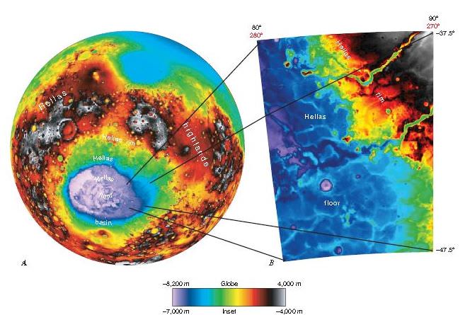
Hellas Planitia extends across about 50° in longitude and more than 20° in latitude. From data from the Mars Orbiter LaserAltimeter (MOLA).
[/caption]
Was the expansive Hellas Basin on Mars at one time a giant lake? A new geologic mapping project shows evidence of sedimentary deposits consistent with what would relate to large standing bodies of water. Fine-layered outcrops around the eastern rim of Hellas basin have been interpreted as a series of sedimentary deposits resulting from erosion and transport of highland rim materials into a basin-wide standing body of water. “This mapping makes geologic interpretations consistent with previous studies, and constrains the timing of these putative lakes to the early-middle Noachian period on Mars, between 4.5 and 3.5 billion years ago,” said Dr. Leslie Bleamaster, research scientist at the Planetary Science Institute.
Hellas basin, more than 2,000 km across and 8 km deep, is the largest recognized impact structure on the Martian surface.
Using data from a variety of spacecraft, including the Viking Orbiter, the Mars Global Surveyor and Mars Odyssey, the researchers characterized the geologic materials and processes that have shaped the Hellas Planetia region on the southern hemisphere of Mars.
The mapping team searched through high-resolution images and found the eastern part of Hellas Planitia, where the fine-layered floor deposits were discovered, “is unique in nature representing a confluence between sedimentary sources and sinks.”
“Our mapping and evaluation of landforms and materials of the Hellas region from the basin rim to floor provides further insight into Martian climate regimes and into the abundance, distribution, and flux of volatiles through history,” Bleamaster said.
The mapping project reinforces earlier research that initially proposed Hellas-wide lakes citing different evidence in the west, he said. Take a look a the new map along with a explanatory pamphlet.
You’ve probably seen “A Glorious Dawn” –– the autotune wonder that allowed Carl Sagan to sing to us. The Symphony of Science music video series has been steadily adding new sciency music videos, and the new “The Case for Mars” is the sixth installment. It features Robert Zubrin, Carl Sagan, Brian Cox, and Penelope Boston. John Boswell, the head musician and producer behind the Symphony of Science says this new video is intended to pique curiosity about the planet Mars and to promote human exploration of it.
Mars500 crew just seconds before ingressing their module for a 520 day stay in June 2010. Credit: ESA
[/caption]
Six men from Europe, Russia and China embarked on a 520-day mock mission to Mars, heading out to a crew module in a warehouse in Moscow and locking the hatches behind them today. The mission runs from June 2010 to November 2011, and like a real Mars mission, the crew will live and work like astronauts, eating special food and exercising the same way as crews aboard the International Space Station. Additionally their communications with their mission control and anyone else from the rest of the world will have a delay of up to 40 minutes.
A joint project between the Russian space agency and ESA, officials said the mood was serious, intense but very determined in the Mars500 facility at the Institute of Biomedical Problems in Moscow as the crew talked to the press and then walked into the modules.
Diego Urbina and Romain Charles from Europe, Sukhrob Kamolov, Alexey Sitev, Alexandr Smoleevskiy and Mikhail Sinelnikov from Russia and Wang Yue from China will have a mission that is as ‘real’ as possible. Their mission is to ‘fly to Mars’ in 250 days, divide in two groups, ‘land on and explore Mars’ for a month and ‘return to Earth’ in 230 days, in their special facility imitating an interplanetary spacecraft, lander and Martian terrain. The Mars 500 facility. Credit: ESA
“It will be trying for all of us. We cannot see our family, we cannot see our friends, but I think it is all a glorious time in our lives,” said Chinese participant Wang Yue, 27, ahead of the experiment.
In addition to evaluating many new technologies, Mars500 will test of human endurance and psychological issues of being confined in a small space and being away from family and friends and a normal Earth-life.
The crew will be keeping online diaries and provide video updates to ESA’s Mars500 site.


 CTX close-up (image B01_009932_2370). CRISM mineral maps from observations FRT0000BAD4 and FRT0000C63C are overlaid in red (smectites or chlorite-prehnite) and green (olivine). The white dashed lines indicate the boundaries of the two adjacent observations. (C) HiRISE close-up (image PSP006860_2370) overlain by CRISM mineral maps. No HiRISE data are available over the chlorite-prehnite unit. Image courtesy of Science/AAAS")
 CTX closeup (image P20_008686_2356). CRISM mineral maps from observation FRT0000ADA4 are overlain in color. The white dashed lines indicate the boundaries of the CRISM observation. (C) HiRISE close-up (image PSP_009332_2360) of the Al-phyllosilicate “montmorillonite”-bearing unit. The sources of the material are the bright outcrops near the scarp summit (right), whereas the light-toned unit (left) is material transported downslope. (D) HiRISE close-up (image PSP_009332_2360) showing outcrops of olivine, Fe/Mg-, and Al-phyllosilicates in close spatial association. Image courtesy of Science/AAAS")