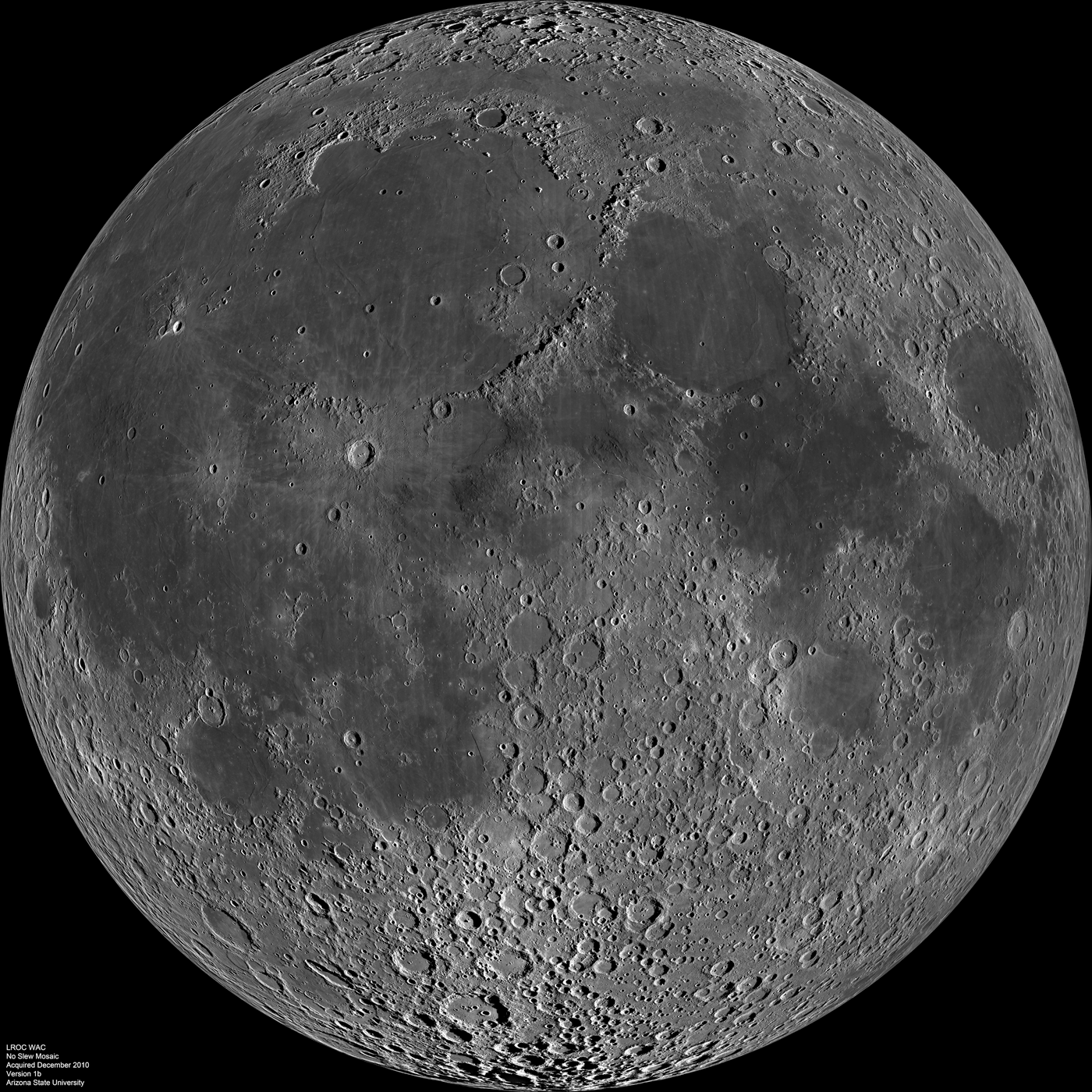
Lunar Reconnaissance Orbiter Wide Angle Camera mosaic of the lunar nearside. Credit: NASA/GSFC/Arizona State University.
[/caption]
Take a gander at this brand new image of the Moon from the Lunar Reconnaissance Orbiter, which is one of the largest and highest resolution images ever compiled of the near-side of the Moon. For two weeks in mid-December 2010, LRO’s orbit allowed the spacecraft to remain looking straight down. Gathering over 1,300 images during this time, LRO’s imaging run allowed the team to compile a monstrous 24,000 x 24,000 pixel mosaic from the Wide Angle Camera (WAC), with a resolution of approximately 145 meters per pixel. The detail is nothing short of spectacular.
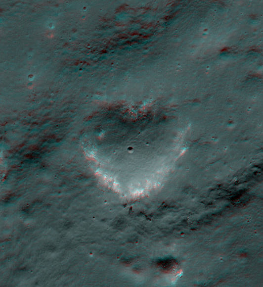
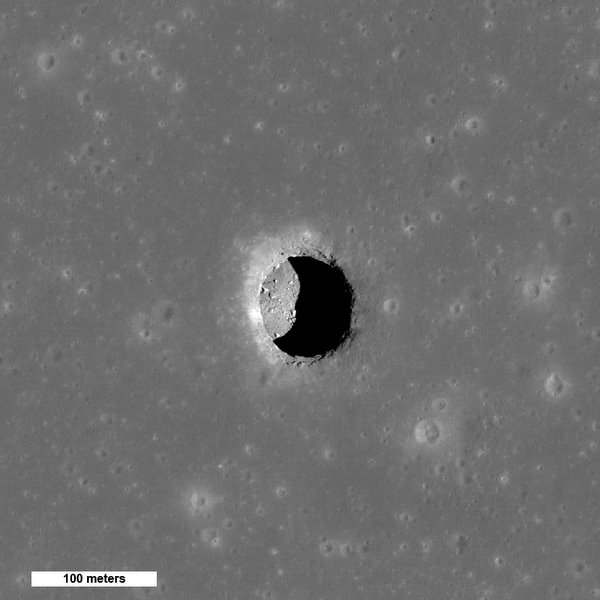
The LROC NAC acquired an oblique view of the Marius Hills pit with just the right angle to reveal an overhang, with a pit below, which is about 65 meters in diameter. Credit: NASA/GSFC/Arizona State University.
[/caption]
Follow-up observations of a potential ‘skylight’ in a lava tube on the Moon has revealed a cavernous lunar pit in the Marius Hills region, with a view of the interior and bottom of the pit. The sun angle, camera angle and lighting conditions were just right for the Lunar Reconnaissance Orbiter camera to look all the way down to the floor of the pit. And this is no small hole in the ground — the LRO team says this pit is about 65 meters in diameter! This latest image confirms this object is actually a subsurface cave; a lava tube close to the surface where part of it has collapsed. These lava tubes could be great locations for lunar bases that could protect human explorers from dangers such as cosmic rays, meteorite impacts, and the extreme temperature differences between the lunar day and night.
This is the fourth time that this particular lunar pit has been imaged. Since LRO is constantly orbiting the Moon and it completes a full cycle of lunar imaging each month, the team can do follow up observations of previous discoveries and re-image targets under different lighting conditions.
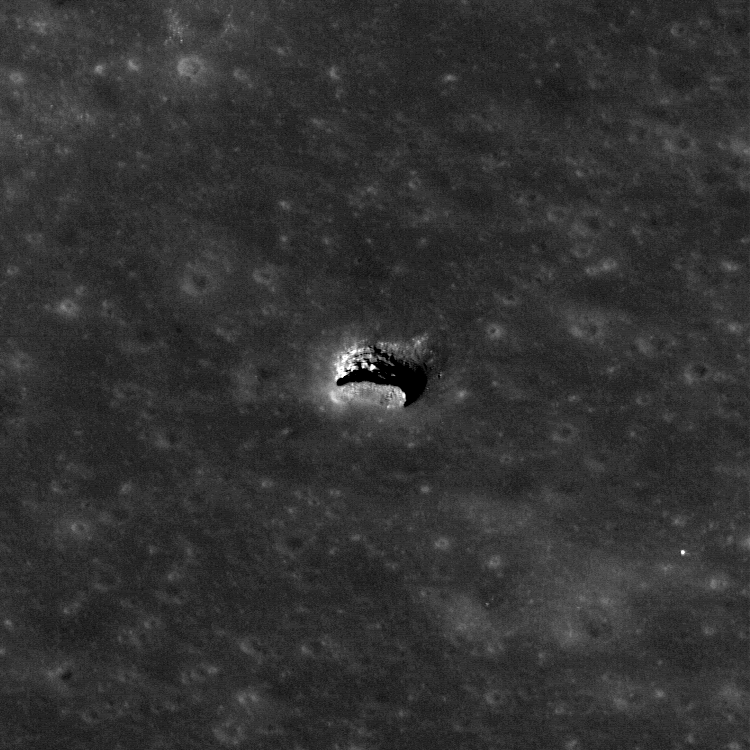
An image taken about a year ago showing the dark entrance to the Marius Hills pit. Credit: NASA/GSFC/Arizona State University
Previous images had revealed the dark, cave-like entrance, and another showed part of the pit wall.
For this fourth imaging run, the spacecraft slewed 43° to the east and the solar incidence angle was 34° from vertical. This was just the right angle so that if there actually was an open lava tube extending horizontally its floor would be illuminated.
The LROC team hit paydirt (or pay-regolith, if you will).
With LRO’s Narrow Angle Camera, the team was able to image a few meters under the overhang to show the interior of this sublunarean void. With this oblique angle, they were also able to capture the layered nature of the mare bedrock in the pit walls. These exposed layers give scientists important clues as to how the vast mare were deposited.
The collection of images now verifies this is actually a cavernous subsurface cave. These pits had been predicted to exist, based on the understanding of the geomorphology of mare deposits and lava flow behavior on Earth, but never directly imaged before.
A graphic of the imaging geometry in cross section, which allows a view of the lava tube floor. Arizona State University.
The LROC team will be presenting their findings about this pit and others that have been imaged at the Lunar and Planetary Science Conference. You can read their abstract here. (pdf file).
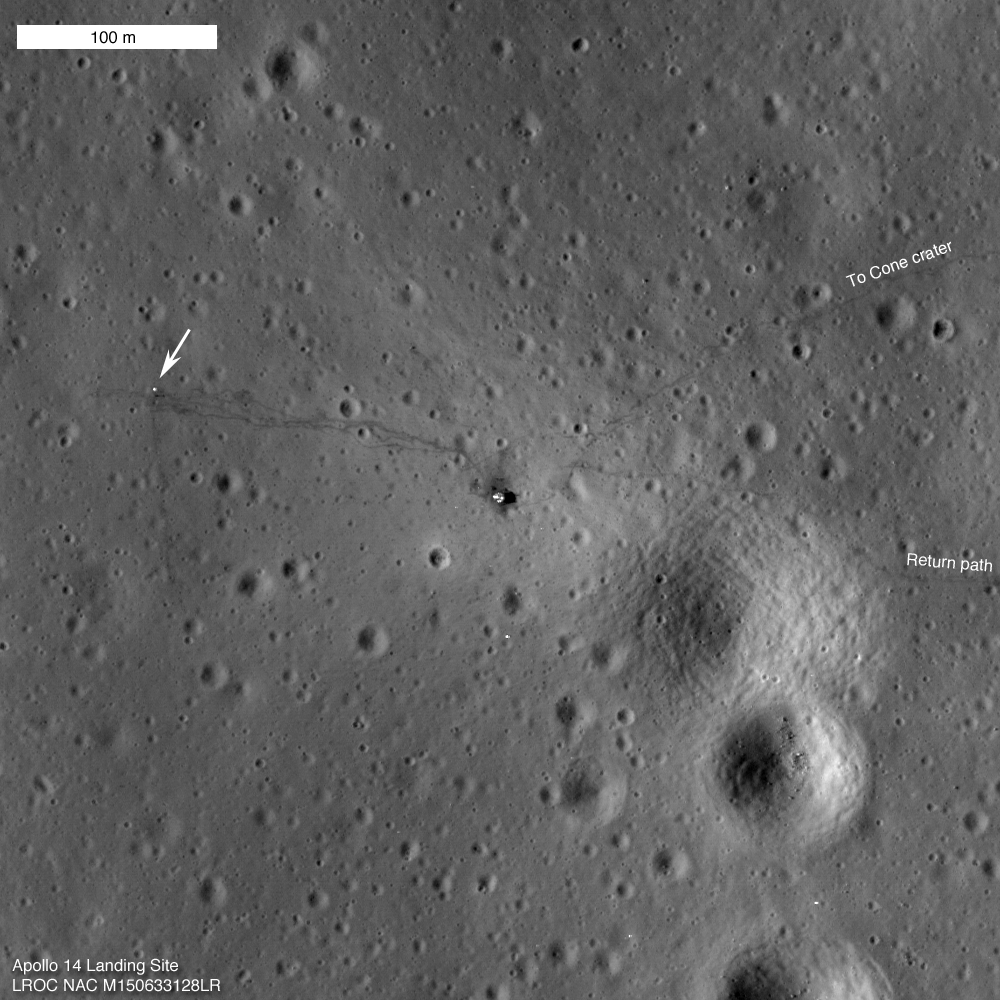
Latest view of the Apollo 14 landing site by LRO. Credit: NASA/GSFC/Arizona State University
[/caption]
40 years ago this week, the Apollo 14 crew landed on the Moon. Here’s the latest look at their landing site, just downloaded from the Lunar Reconnaissance Orbiter’s Narrow Angle Cameras. Even though LRO has imaged this area before, this seems to be a much better, crisper view of the lander and the ALSEP experiment package left of the Moon by Al Shepard and Edgar Mitchell. Also visible are the tracks left where the astronauts walked repeatedly in a “high traffic zone” and perhaps by the Modularized Equipment Transporter (MET) wheelbarrow-like carrier used on Apollo 14. Below are a couple of close-up looks at the image.
A closer view of the Apollo 14 landing site. Credit: NASA/GSFC/Arizona State University
The LROC folks say that every time LRO passes overhead the different landing sites, the Sun is at a different position so each image gives a different perspective. Additionally, since the position of the lunar modules and other pieces of hardware are very accurately known, the LROC team can check the accuracy of the mission-provided ephemeris.
Closer yet: Apollo 14, as seen by LRO, cleaned up and zoomed in by Carlos Ayala.
Thanks to UT reader Carlos Ayala who sent in this this sharpened and enhanced “closer” close-up. He captured the original image on the LRO site, and “using CS3 I enlarged the area and applied a Bicubic smoothing filter to the re-sampled image. The resulting image is set to 1200 x 1200 pixels,” he wrote us. Click on the image for a larger version.
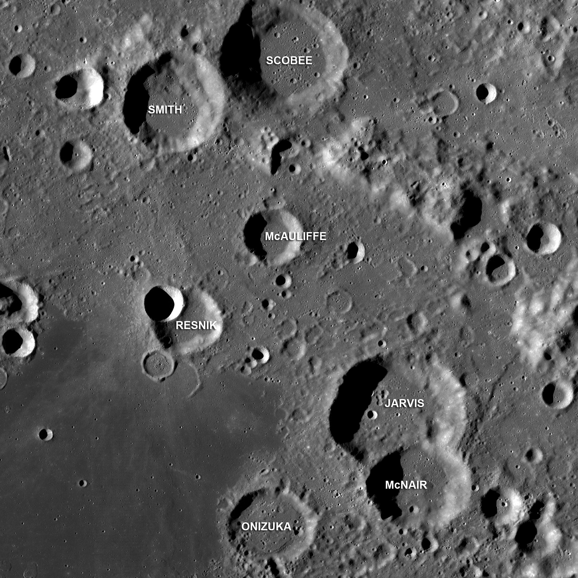
Craters in the center of Apollo basin named after Space Shuttle Challenger astronauts. Credit: NASA/GSFC/Arizona State University.
[/caption]
Shortly after the loss of the Space Shuttle Challenger in 1986, seven craters on the eastern rim of the Apollo basin were named after the crew: Gregory Jarvis, Christa McAuliffe, Ronald McNair, Ellison Onizuka, Judith Resnik, Dick Scobee, Michael Smith. The Lunar Reconnaissance Orbiter Wide Angle Camera recently took this image of the region. Below is a video from the Kaguya spacecraft flying over the area.
According to OnOrbit, the crater “Onizuka” is incorrectly identified in this video. Rather, “Onizuka” is the crater next and to the right of the one labeled in the video as “The Onizuka”.
The Apollo Basin is not where I would have guessed — the area around the Moon’s equator on the near side where all the Apollo landings took place — but instead is a 524 km-diameter impact basin located within the center of the the giant South Pole-Aitken basin, (36°S, 209°E).
LROC NAC oblique view of Aitken crater, including the central peak, and northern walls. The scene is about 30 km wide. Credit: NASA/GSFC/Arizona State University
[/caption]
When people look out of the corner of their eyes, they often don’t see things very clearly. But that’s not the case for the Lunar Reconnaissance Orbiter’s cameras. Occasionally LRO’s cameras are commanded to look off to the side at extreme angles, and the results, thought not frequent, are incredible. This stunning image of the central uplifts inside of Aitken Crater was taken on January 11, 2011. Here, LROC was looking over the southwest ridge of its central peak, and in the distance the lower portion of the northeastern walls of Aitken crater itself is just visible. To quote the Fred Haise character in the movie Apollo 13, this image makes me tempted to take a spacecraft down and “do some prospecting.” …
Mostly, LRO looks straight down for its images, but has collected a limited number of these oblique views of the lunar surface. They are very useful for engineering purposes, but also provide a unique view for visualizing key geologic features on the lunar surface — like Aitken. And usually, they are beautiful shots.
Aitken Crater(~135 km in diameter) is of interest because it is is one of the most geologically diverse settings on the farside. The floor of the crater is covered in mare basalt, which are quite rare on the lunar farside, and lunar scientists are still trying to figure out why. Aitken is also on the northern rim of the great South Pole-Aitken basin, the oldest and largest impact basin on the Moon and one of the oldest and largest impact basins in the whole Solar System! Further exploration of the South Pole-Aitken basin is one of the highest priorities for planetary science in the next decade.
The Moon's south pole, as see by the Lunar Reconnaissance Orbier. Credit: NASA/GSFC/Arizona State University.
[/caption]
No, this is not a wheel of moldy Swiss Cheese. It’s an illumination map of the South Pole of the Moon. There are some areas on the poles of the Moon, particularly the interior of craters, that lie in permanent shadow while other areas remain sunlit for the majority of the year. This image was taken by the Lunar Reconnaissance Orbiter Camera, which has a primary objective of unambiguously identifying these regions. This composite image contains over 1,700 images taken of the same area by the LROC Wide Angle Camera (WAC) over a six month period, which works out to six lunar days.
Here’s how the LROC team described how they created the image:
“Each image was map projected and converted to a binary image (if the ground was illuminated that pixel was set to one, and if shadowed zero) to differentiate between sunlit and shadowed regions. All the binary images were then stacked, and then for each pixel it was determined what percentage of the time during six months that spot was illuminated. Presto – an illumination map! The LROC team is making daily (which is about 28 Earth days) and yearly illumination maps for both poles. Such maps will provide the foundation for planning future robotic and human missions to the poles.”
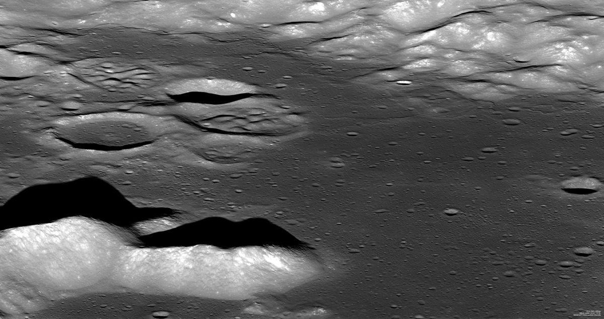
Marius Hills region on the Moon, from LRO's Wide Angle Camera.
[/caption]
Here’s a look at the Moon in a way we’ve never quite seen it before: a close up, but wide angle view. The Lunar Reconnaissance Orbiter camera actually consists of three cameras: there are two narrow-angle cameras which make high-resolution, black-and-white images of the surface, with resolutions down to 1 meter (about 3.3 feet). A third, a wide-angle camera (WAC), takes color and ultraviolet images over the complete lunar surface at 100-meter (almost 330-foot) resolution. However, the raw wide-angle images are somewhat distorted by the camera, but Maurice Collins, a Moon enthusiast from New Zealand, found that putting several images together in a mosaic removes a lot of the distortions and produces a much clearer image. The results are nothing short of stunning; here are a few example of Maurice’s handiwork, including this jaw-dropping image of the Marius Hills region of the Moon. Click on any of these images for a larger version on Maurice’s website, Moon Science
Copernicus Crater on the Moon, captured by LROC's wide angle camera. Image processing by Maurice Collins
Maurice told me that he has been studying the Moon for about ten years now, and he does telescopic imaging of the Moon from his backyard Palmerston North, New Zealand as well as study the various spacecraft data. “I found out how to process the WAC images from Rick Evans (his website is here ) for the Octave processing method, and I also use a tool developed by Jim Mosher for another quicker technique,” Maurice said. Several of Maurice’s images have been featured on the Lunar Photo of the Day website.
Aristarchus Crater, as seen by LROC's wide angle camera. Image processing by Maurice Collins
Other areas of lunar imaging work he has done is using the Lunar Terminator Visualization Tool (LTVT) to study the lunar topography from the Lunar Orbiter Laser Altimeter (LOLA) digital elevation model laser altimeter data.
“Using a previous DEM from the Kaguya spacecraft I discovered a new large (630km long) mountain ridge radial to the Imbrium basin which I have nicknamed “Shannen Ridge” after my 9 year old daughter,” he said. See the image of Shannen Ridge here.
Maurice said he is usually out every clear night imaging or observing the Moon with his telescope. Thanks to Maurice for his wonderful work, and for allowing us at Universe Today to post some of the images. Check out his complete cache of WAC mosaics at his website.
Spectacular high Sun view of the Mare Tranquillitatis pit crater revealing boulders on an otherwise smooth floor. Image is 400 meters wide, north is up, NAC M126710873R [NASA/GSFC/Arizona State University].
As promised, the Lunar Reconnaissance Orbiter is taking more detailed looks at the lunar pits, or lava tubes that have been discovered by LRO and the Kaguya spacecraft. These are deep holes on the moon that could open into vast underground tunnels, and could serve as a safe, radiation shielding habitats for future human lunar explorers. Plus, they are just plain intriguing! This image of a pit found in the Sea of Tranquility (Mare Tranquillitatis) was taken as the Sun was almost straight overhead, illuminating the region. By comparing this image with previous images that have different lighting, scientists can estimate the depth of the pit. They believe it to be over 100 meters!
See more “in-depth” look at more of the caves on the Moon, below:
Two views of Mare Ingenii pit Credit: NASA/GSFC/Arizona State University.
These two images show a pit in Mare Ingenii, which reveal different portions of the floor as the Sun crosses from west to east. Again, by measuring the shadows in different lighting, the Sea of Cleverness pit appears to be about 70 meters deep and about 120 meters wide.
These long, winding lava tubes are like structures we have on Earth. They are created when the top of a stream of molten rock solidifies and the lava inside drains away, leaving a hollow tube of rock. There have been hints that the Moon had lava tubes based on observations of long, winding depressions carved into the lunar surface by the flow of lava, called sinuous rilles.
If a human geologist could ever climb down inside these tubes on the Moon, we could learn so much about the Moon’s history, and sort of travel back in time by studying the different layers on the Moon, just like we do on Earth.
Three views of the Marius Hills pit. Credit: NASA/GSFC/Arizona State University.
LROC has now imaged the Marius Hills pit three times, each time with very different lighting. The center view has an incidence angle of 25° that illuminates about three-quarters of the floor. The Marius pit is about 34 meters deep and 65 by 90 meters wide.
Read more about the Ingenii, Tranquillitatis, and Marius pits at the LROC website, and you can search the nearby area for clues in the full LROC NAC frame that may help determine if an extended lava tube system still exists beneath the surface.
High-resolution view from LRO of an unusual crater near Moon’s north pole, Rozhdestvensky (110 miles, or 177 kilometers in diameter). Credit: NASA
[/caption]
Radar has been used since the 1960s to map the lunar surface, but until recently it has been difficult to get a good look at the Moon’s poles. In 2009, the Mini-SAR radar instrument on the Chandrayaan-1 spacecraft was able to map more than 95% of both poles at 150 meter radar resolution, and now the Mini-RF instrument on the Lunar Reconnaissance Orbiter — which has 10 times the resolution of the Mini-SAR — is about halfway through its first high-resolution mapping campaign of the poles. The two instruments are revealing there are likely massive amounts of water in the permanently shadowed craters at the poles, with over 600 million metric tons at the north pole alone. “If that was turned into rocket fuel, it would be enough to launch the equivalent of one Space Shuttle per day for over 2,000 years,” said Paul Spudis, principal investigator for the Mini-SAR, speaking at the annual Lunar Forum at the Ames Research Center in July.
Both Spudis and Ben Bussey, principal investigator for LRO’s Mini-RF shared images from their respective instruments at the Forum, highlighting polar craters that exhibit unusual radar properties consistent with the presence of ice.
They have found over 40 craters on the Moon’s north pole that exhibit these properties.
Both instruments provide details of the interior of shadowed craters, not able to be seen in visible light. In particular, a measurement called the circular polarization ratio (CPR) shows the characteristics of the radar echoes, which give clues to the nature of the surface materials in dark areas. The instruments send pulses of left-polarized radio waves to measure the surface roughness of the Moon. While smooth surfaces send back a reversed, right-polarized wave, rough areas return left-polarized waves. Ice, which is transparent to radio waves, also sends back left-polarized waves. The instruments measure the ratio of left to right circular polarized power sent back, which is the CPR.
Few places – even in our solar system — have a CPR greater than 1 but such places have thick deposits of ice, such as Martian polar caps, or the icy Galilean satellites. They are also seen in rough, rocky ejecta around fresh, young craters, but there, scientists also observe high CPR outside the crater rim such as in this image, below of the Main L crater on the Moon.
The fresh impact crater Main L (14 km diameter), which shows high CPR inside and outside its rim. The histograms at right show that the high CPR values within (red line) and outside the crater rim (green line) are nearly identical. Credit: NASA
Most of the Moon has low CPR, but dozens of anomalous north pole craters, such as a small 8 km crater within the larger Rozhdestvensky crater, had a high CPR on the inside, with a low CPR on the rims. That suggests some material within the craters, rather than surface roughness, caused the high CPR signal.
“Geologically, we don’t expect rough, fresh surfaces to be present inside a crater rim but absent outside of it,” Spudis said. “This confirms the high CPR in these anomalous craters is not caused by surface roughness, and we interpret this to mean that water ice is present in these craters.” An “anomalous” crater on the floor of Rozhdestvensky, near the north pole of the Moon. The histogram of CPR values clearly shows that interior points (red line) have higher CPR values than those outside the crater rim (green line). Credit: NASA
Additionally, the ice would have to be several meters thick to give this signature. “To see this elevated CPR effect, the ice must have a thickness on the order of tens of wavelengths of the radar used,” he said. “Our radar wavelength is 12.6 cm, therefore we think that the ice must be at least two meters thick and relatively pure.”
Recent Mini-SAR images (top image) from LRO confirm the Chandrayaan-1 data, with even better resolution. The Mini-RF, Bussey said, is equivalent to a combination of the Arecibo Observatory and the Greenbank Radio telescope in looking at the Moon. “Our polar campaign will map from 70 degrees to the poles and so far we are very pleased with the coverage and quality of the data,” Bussey said.
Spudis said they are seeing less anamolous craters on the Moon’s south pole, but both he and Bussey are looking forward to comparing more data between the two radar instruments to learn more about the permanently shadowed craters on the Moon.
Additionally, other instruments on LRO will also provide insights into the makeup of these anomalous craters.


, which shows high CPR inside and outside its rim. The histograms at right show that the high CPR values within (red line) and outside the crater rim (green line) are nearly identical. Credit: NASA")
 have higher CPR values than those outside the crater rim (green line). Credit: NASA")