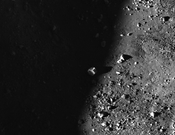
Why Are Lunar Shadows So Dark?

A lunar boulder peeks out into the sunlight. (NASA/GSFC/Arizona State University)

[/caption]

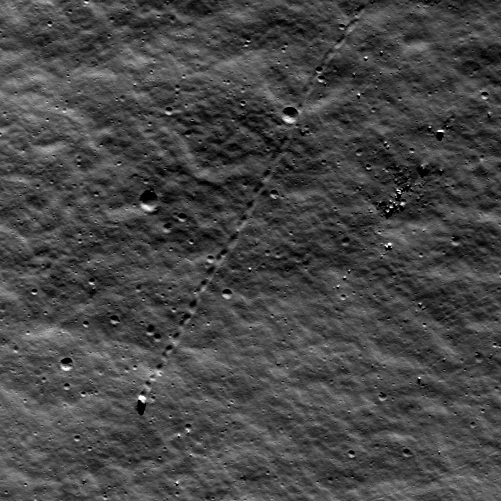
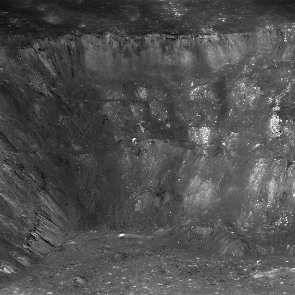
A lunar boulder catches the last edge of the setting sunlight in this image from the Lunar Reconnaissance Orbiter Camera. The boulders litter the floor of an unnamed 3.5 km wide (2.17 mile wide) crater located within the much larger crater Lobachevskiy. The smaller crater’s rim casts its shadow along the left side of the image, and raises the question: why are shadows on the Moon so dark?

On Earth, air scatters light and allows objects not in direct sunlight to be still well-lit. This is an effect called Rayleigh scattering, named for the British Nobel-winning physicist Lord Rayleigh (John William Strutt.) Rayleigh scattering is the reason why the sky is blue, and (for the most part) why you can still read a magazine perfectly well under an umbrella at the beach.

On the Moon there is no air, no Rayleigh scattering. So shadows are very dark and, where sunlight hits, very bright. Shadowed areas are dramatically murky, like in the LROC image above, yet there’s still some light bouncing around in there — this is due to reflected light from the lunar surface itself.

Buzz was well-lit by reflected light, even in Eagle's shadow. (NASA/Apollo Image Archive)

Lunar regolith is composed of fine, angular particles of very reflective dust. It tends to reflect light directly back at the source, and will illuminate objects within shadows as well — as seen in Apollo mission photographs. Astronauts within the shadow of the landing modules were still visible, and their suits were well illuminated by reflected light from the lunar surface. Some people have used this as “proof” that the landings were actually filmed on a sound stage under artificial lights, but in reality it’s all due to reflected light.

Here’s a great run-though of the lunar landing photos and how lighting on the Moon works.

So even though air isn’t scattering the sunlight on the Moon, there’s still enough reflection to sneak light into the shadows… but not much. It gets dark — and quickly cold — in there!

And if you’re one of those who likes to get a better look into the shadows, here’s the same image above with the dark areas brightened enough to see details:

Shadow world revealed! (NASA/GSFC/Arizona State University/J. Major)

Some interesting boulder trails in there!

See this image on Arizona State University’s LROC news page here, and zoom into the full NAC scan here.

A Bouncing Moon Boulder

A large boulder stopped on its way down a sloping wall in the central peak of Schiller crater on the Moon. Credit: NASA/GSFC/Arizona State University.

[/caption]

One solitary boulder on the Moon apparently decided to take a little journey. The Lunar Reconnaissance Orbiter Camera captured the track of a bouncing, rolling 9-meter boulder that used to sit along the rim of a crater. From the pristine nature of the tracks, it might seem that the rock may have taken its trip just recently. But with the high resolution capability of the LROC, scientists can see that a few tiny craters are superimposed among the track and therefore post-date the time the boulder traveled. Scientists estimate this track was created 50-100 million years ago.

“Though long ago to humans, however, this boulder’s journey was made in geologically recent times,” wrote lunar scientist James Ashley on the LROC website. “Studies suggest that regolith development from micrometeorite impacts will erase tracks like these over time intervals of tens of millions of years…Eventually its track will be erased completely.”

What might have caused the rock to roll so recently? Ashley said perhaps this boulder was sent on its way by ground-shaking caused by the violence of a nearby impact. Perhaps a direct hit by a small meteoroid did the job.

This isn’t the first time LRO has captured evidence of “moving” rocks. See our previous article about several other images of bouncing boulders.

Source: LROC

LRO Lets You Stand on the Rim of Aristarchus Crater

West wall of Aristarchus crater seen obliquely by the LROC NACs from an altitude of only 26 km. Scene is about 12 km wide at the base. Credit: NASA/GSFC/Arizona State University.

[/caption]

Have you ever you looked up at the bright, cavernous Aristarchus Crater on the Moon through a telescope or binoculars and wondered what it would be like to stand on the rim and peer inside? Spectacular new views from the Lunar Reconnaissance Orbiter is almost as good as being there, and a new video lets you “rappel” down and take a closer look at the west side of the crater walls.

Full panoramic view of the west wall of Aristarchus crater revealing impact melt deposits, exposures of high reflectance anorthosite, streamers of pyroclastic ash, and blocks up to 100 meters in size. Full width of panorama is about 25 km. Credit: NASA/GSFC/Arizona State University.

LRO Camera Principal Investigator Mark Robinson describes the region around the crater, known as the Aristarchus plateau, as one of the most geologically diverse places on the Moon. “A mysterious raised flat plateau, a giant rille carved by enormous outpourings of lava, fields of explosive volcanic ash, and all surrounded by massive flood basalts,” Robinson wrote on the LROC website. “A relatively recent asteroid (or comet) slammed into this geologic wonderland, blowing a giant hole in the ground revealing a cross section of over 3,000 meters (9,800 ft) of geology. No wonder planners for the Apollo missions put this plateau high on its list of targets for human exploration.”

These new amazing images were acquired on November 10, 2011 as LRO passed only 26 km (16.2 miles) above the surface, which is about two times lower than normal, due to LRO’s current elliptical orbit. The spacecraft was slewed to the west for an oblique or “sideways” look at the crater, instead of looking straight down as LRO normally does, to provide this unique perspective on Aristarchus. For a sense of scale, Robinson said that altitude is only a little over twice as high as commercial jets fly above the Earth. This crater is only one-tenth the size of Earth’s Grand Canyon, but the views from up above are similarly spectacular.

The location of Aristarchus Crater. Credit: Wikipedia

Aristarchus crater is located on the southeast edge of the Aristarchus Plateau. This yawning crater is 40 km wide and 3.5 km deep. The edges appear scalloped, almost like it crater was strip-mined. Since the crater is relatively young, Aristarchus is one of the brightest regions on the Moon. Robinson says these bright rocks may be anorthositic like the highlands, or they may be a more silicic rock like granite — or both.

“Although granites have been found in Apollo rock samples, the formation of granite on the Moon is not well understood at this time – another reason why we need to get samples from this region,” he said.

A 'straight down' view of Aristarchus, Aristarchus crater.. Small white arrows indicate approximate corners of the NAC panorama. Vertical line on right shows LRO orbit ground track Credit: NASA/GSFC/Arizona State University.

From this ‘straight down’ view, you can see the bright ejecta, contrasted by darker areas, which reflects the compositional difference between the various rocks in the region.

On the floor of Aristarchus crater is a wide variety of lunar rocks and geologic processes.

“Diverse materials such as dark, multilayered mare basalts in the walls, bright crustal rocks in the central peak, impact melt, and even regional pyroclastic materials blanketing the crater are brought to the floor and accumulated through mass wasting, creating a bountiful trove of geologic materials,” Robinson said.

Who’s ready to go exploring?!

Click here to see the full-resolution panoramic view of Aristarchus Crater.

Source: LROC

Hat tip and inspiration from Stu Atkinson

September is Moon Month!

Jane Houston Jones from JPL provides information on what’s up for September, focusing on the Moon. The next few days will be a good time to look for the Apollo landing sites — and no, you won’t be able to see any details from Earth, even with a good telescope, but it is fun to try and locate the areas humans have walked on the Moon. Jane shows you how. And of course, the GRAIL mission to the Moon is scheduled to launch on Sept. 8. Learn more about the mission here.

And as a heads up, look for new images of the Apollo landing sites from the Lunar Reconnaissance Orbiter that will be released next week. LRO recently moved closer to the Moon to take new and improved images of these historic sites. We’ll share them as soon as they are available.

LRO to Move in For Closer Look at the Apollo Landing Sites

Artist concept of LRO in lunar orbit. Credit: NASA

[/caption]

NASA’s Lunar Reconnaissance Orbiter (LRO) is changing our view of the Moon by literally bringing it into sharper focus with its three high resolution cameras. But now, things are about to get even sharper. Today, LRO fired its thrusters to begin dipping down from its usual orbit about 50 km above the surface and moving to an orbit that will allow the spacecraft’s cameras me to image the Apollo sites from about 20 km away.

“This will allow me to obtain images of the Apollo sites that are about 4 times sharper than my current best images,” said the LRO spacecraft on Twitter.


This is just a temporary orbit and the spacecraft will take images of and around the Apollo sites between August 14 and 19, 2011. After that, the spacecraft will return to the 50-km-orbit until December.

LRO has two narrow angle cameras (NACs) and one wide angle camera (WAC).

According to Mark Robinson, LROC Principal Investigator, who spoke at the Lunar Forum at Ames Research Center last month, as of the end of July, 2011 the amount of data returned by LRO has been about 400 gigabits of data every day, which includes 371,027 high resolution images. The WAC has taken about 160,000 images, with about 90,000 in color. In total, the spacecraft has imaged the entire Moon about 20 times with the WAC, and has imaged 20 per cent of the moon with NACs, which provides a narrower but higher resolution view.

“We want to map the whole moon at 50 cm/pixel to 200 cm/pixel, and that would be LROC’s legacy for the next 100 years of lunar exploration and science,” Robinson said.

He noted that all three cameras are performing way better than he had hoped.

“We are very excited about the quality of the data,” Robinson said.

So get ready for a little more quality views of the Apollo landing sites!

Update: as commenter MoonOrBust noted, the LRO Twitter feed had an addendum later in the day, adding that there are several technical challenges associated with getting improved resolution images at the lower altitude orbit. For example, the spacecraft will not slow from its orbital speed of about 1.6 km/s (about 3,500 mph) when it gets closer to the Moon’s surface, which might cause some image blurring, particularly for the LROC Narrow Angle Camera images. “However, it will certainly be fun to compare the images from the different orbits!” the spacecraft Tweeted.

How LRO Plans to Watch the Lunar Eclipse from the Moon

What will the June 15th lunar eclipse look like from the Moon itself? Luckily, we’ve got the Lunar Reconnaissance Orbiter circling the Moon, and we can find out. However, most of the instruments on LRO will be powering down during the eclipse, but one instrument, called Diviner, will stay on. “It will be like a nap with one eye open!” the LRO spacecraft said on Facebook. The Diviner Lunar Radiometer instrument will record how quickly different areas on the moon’s day side cool off during the eclipse. Since large boulders cool more slowly than a fine-grained or dusty surface, Diviner will be able to see what areas are covered with boulders and what regions are blanketed by dust.
Continue reading “How LRO Plans to Watch the Lunar Eclipse from the Moon”

One Year of the Moon in 2.5 Minutes

The New Moon occurs when the Moon and Sun are at the same geocentric ecliptic longitude. The part of the Moon facing us is completely in shadow then. Pictured here is the traditional New Moon, the earliest visible waxing crescent, which signals the start of a new month in many lunar and lunisolar calendars. Credit: NASA Goddard SVC

We don’t always have the time or ability to see the Moon every night of the year, but this video, from the Goddard Space Flight Center Scientific Visualization Studio, uses data from the Lunar Reconnaissance Orbiter and compresses one month into 12 seconds and one year into 2.5 minutes. This is how the Moon will look to us on Earth during the entire year of 2011. While the Moon always keeps the same face to us, it’s not exactly the same face. Because of the tilt in its axis and shape of its orbit, we see the Moon from slightly different angles over the course of a month, and the year. Normally, we don’t see how the Moon “wobbles” in its orbit, but seeing the Moon’s year this quickly, we can see the changes in libration, and axis tilt — as well as the most noticeable changes, the Moon’s phases.


This animation is the most accurate to date, showing shadows and other features on the Moon in incredible detail. This is thanks to the Lunar Orbiter Laser Altimeter (LOLA) aboard LRO. The shadows are based on the global elevation map being developed from measurements by the LOLA, and the instrument has already taken more than 10 times as many elevation measurements as all previous missions combined.

If you want to know what the Moon looks like “right now” this page from the SVC is updated every hour showing the Moon’s geocentric phase, libration, position angle of the axis, and apparent diameter of the Moon. It also has images showing the different phases of the Moon, too.

[/caption]

Celestial north is up in these images, corresponding to the view from the northern hemisphere. The descriptions of the print resolution stills also assume a northern hemisphere orientation. To adjust for southern hemisphere views, rotate the images 180 degrees, and substitute “north” for “south” in the descriptions.

Source: Goddard Space Flight Center Science Visualization Studio

Look Inside a Lunar Crater

Brightening the shadowed area reveals details of the crater floor...and even more boulders!

[/caption]

The crater shown above is located in the lunar highlands and is filled with and surrounded by boulders of all sizes and shapes. It is approximately 550 meters (1800 feet) wide yet is still considered a small crater, and could have been caused by either a direct impact by a meteorite or by an ejected bit of material from another impact. Scientists studying the Moon attempt to figure out how small craters like this were formed by their shapes and the material seen around them…although sometimes the same results can be achieved by different events.

For example, when an object from space strikes the Moon, it is typically traveling around 20 km per second (12 miles/sec). If the impact site happens to have a very hard subsurface, it can make a crater with scattered bouldery chunks composed of the hard material around it. But, if a large piece of ejected material from another impact were to strike the lunar surface at a much slower speed, as ejecta typically do (since they travel slower than incoming space debris and the Moon’s escape velocity is fairly low, meaning any ejecta that does fall back to the surface must be traveling slower than 2.38 km/s,) then the ejected chunk could break apart on impact and scatter boulders of itself around the crater…regardless of subsurface composition.

Really the only way to tell for sure which scenario has taken place around a given crater – such as the one above – is to collect and return samples from the site so they can be tested. (Of course that’s much easier said than done!)

You can read more about this image on Arizona State University’s Lunar Reconnaissance Orbiter Camera site here.

And as an added treat, take a look deep into the shadows of the crater’s interior below…I tweaked the image curves in Photoshop to wrestle some of the details out of there!


Brightening the shadowed area reveals details of the crater floor...and even more boulders!

Image credit: NASA/GSFC/Arizona State University. (Edited by J. Major.)

P.S.: Want to see both image versions combined? Click here. (Thanks to Mike C. for the suggestion!)

NASA Lunar Reconnaissance Orbiter Delivers Treasure Trove of Data

LOLA data give us three complementary views of the near side of the moon: the topography (left) along with new maps of the surface slope values (middle) and the roughness of the topography (right). All three views are centered on the relatively young impact crater Tycho, with the Orientale basin on the left side. The slope magnitude indicates the steepness of terrain, while roughness indicates the presence of large blocks, both of which are important for surface operations. Lunar topography is the primary measurement being provided, while ancillary datasets are steadily being filled in at the kilometer scale. Credit: NASA/LRO/LOLA Science Team

[/caption]

NASA’s Lunar Reconnaissance Orbiter (LRO) has completed its initial phase of operations during the exploration phase which lasted one year from Sept. 15, 2009 through Sept. 15, 2010 and has now transitioned to the science phase which will last for several more years depending on the funding available from NASA, fuel reserves and spacecraft health. The exploration phase was in support of NASA’s now cancelled Project Constellation

To mark this occasion NASA released a new data set that includes an overlap of the last data from the exploration phase and the initial measurements from the follow on science mapping and observational phase.

This is the fifth dataset released so far. All the data is accessible at the Planetary Data System (PDS) and the LROC website and includes both the raw data and high level processed information including mosaic maps and images.

LRO was launched on June 18, 2009 atop an Atlas V/Centaur rocket as part of a science satellite duo with NASA’s Lunar Reconnaissance Orbiter & Lunar Crater Observation and Sensing Satellite (LCROSS) from Launch Complex 41 at Cape Canaveral Air Force Station in Florida.

After achieving elliptical orbit, LRO underwent a commissioning phase and the orbit was lowered with thruster firings to an approximately circular mapping orbit at about 50 km altitude.

LRO spacecraft (top) protected by gray colored blankets is equipped with 7 science instruments located at upper right side of spacecraft. Payload fairing in background protects the spacecraft during launch and ascent. Credit: Ken Kremer
LRO was equipped with 7 science instruments that delivered more than 192 terabytes of data and with an unprecedented level of detail. Over 41,000 DVDs would be required to hold the new LRO data set.

“The release of such a comprehensive and rich collection of data, maps and images reinforces the tremendous success we have had with LRO in the Exploration Systems Mission Directorate and with lunar science,” said Michael Wargo, chief lunar scientist of the Exploration Systems Mission Directorate at NASA Headquarters in Washington according to a NASA statement.

The new data set includes a global map produced by the onboard Lunar Reconnaissance Orbiter Camera (LROC) that has a resolution of 100 meters. Working as an armchair astronaut, anyone can zoom in to full resolution with any of the mosaics and go an exploration mission in incredible detail because the mosaics are humongous at 34,748 pixels by 34,748 pixels, or approximately 1.1 gigabytes.

Browse the Lunar Reconnaissance Orbiter Camera (LROC) Image Gallery here:

The amount of data received so far from LRO equals the combined total of all other NASA’s planetary missions. This is because the moon is nearby and LRO has a dedicated ground station.

Topographic map from LRO data. Credit: NASA

Data from the other LRO instruments is included in the release including visual and infrared brightness, temperatures maps from Diviner; locations of water-ice deposits from the Lyman-Alpha Mapping Project (LAMP) especially in the permanently shadowed areas and new maps of slope, roughness and illumination conditions from the Lunar Orbiter Laser Altimeter team.

Additional new maps were generated from data compilations from the Lunar Exploration Neutron Detector (LEND), the Cosmic Ray Telescope for the Effects of Radiation and the Miniature Radio Frequency (mini RF) instruments

The combined result of all this LRO data is to give scientists the best ever scientific view of the moon.

“All these global maps and other data are available at a very high resolution — that’s what makes this release exciting,” said Goddard’s John Keller, the LRO deputy project scientist. “With this valuable collection, researchers worldwide are getting the best view of the moon they have ever had.”

Slope image. Credit: NASA
The Atlas V/Centaur carrying NASA's Lunar Reconnaissance Orbiter & Lunar Crater Observation and Sensing Satellite hurtles off Launch Complex 41 at Cape Canaveral Air Force Station in Florida on June18, 2009. Credit: NASA/Tom Farrar, Kevin O'Connell

Source: NASA Press Release

Lunar Farside Gets Highest Resolution Look Yet from LRO

The lunar farside as never seen before! LROC WAC orthographic projection centered at 180° longitude, 0° latitude. Credit: NASA/GSFC/Arizona State University.

[/caption]

The first time humans were able to catch a glimpse of the far side of the Moon was back in 1959 when the Soviet Luna 3 spacecraft sent back 29 grainy images taken during its successful loop around the Moon. “What a surprise – the farside was a different world, geologically,” said Mark Robinson, principal investigator for the camera on board the Lunar Reconnaissance Orbiter. “Unlike the widespread maria on the nearside, basaltic volcanism was restricted to a relatively few, smaller regions on the farside, and the battered highlands crust dominated.”

Since then, just a handful of spacecraft have taken images of the far side of the Moon, but now, Robinson has had a hand in creating the most detailed view yet of the farside of the Moon. A mosaic of the far side released today is comprised of over 15,000 Wide Angle Camera images acquired between November 2009 and February 2011.


“This WAC mosaic provides the most complete look at the morphology of the farside to date, and will provide a valuable resource for the scientific community,” Robinson wrote on the LROC website. “And it’s simply a spectacular sight!”

And how!

Every month, as LRO circles the Moon, the WAC gathers images to provide nearly complete coverage of the Moon under unique lighting. This mosaic knits together images all with similar lighting. As an added bonus the orbit-to-orbit image overlap provides stereo coverage, and even more images will be released on March 15.

“As the mission progresses, and our knowledge of the lunar photometric function increases, improved and new mosaics will be released!” Robinson said. “Work your way around the Moon with these six orthographic projections constructed from WAC mosaics.”

Click here for more stunning, high resolution views of the Moon.

Source: LROC