
Thanks to the team from the HiRISE camera on board the Mars Reconnaissance Orbiter, we can enjoy these great wintery-looking views of the Red Planet.
Incoming! Meteorite Shockwaves Could Set Off Martian Dust Avalanches
[/caption]
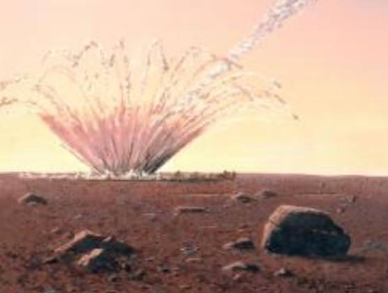
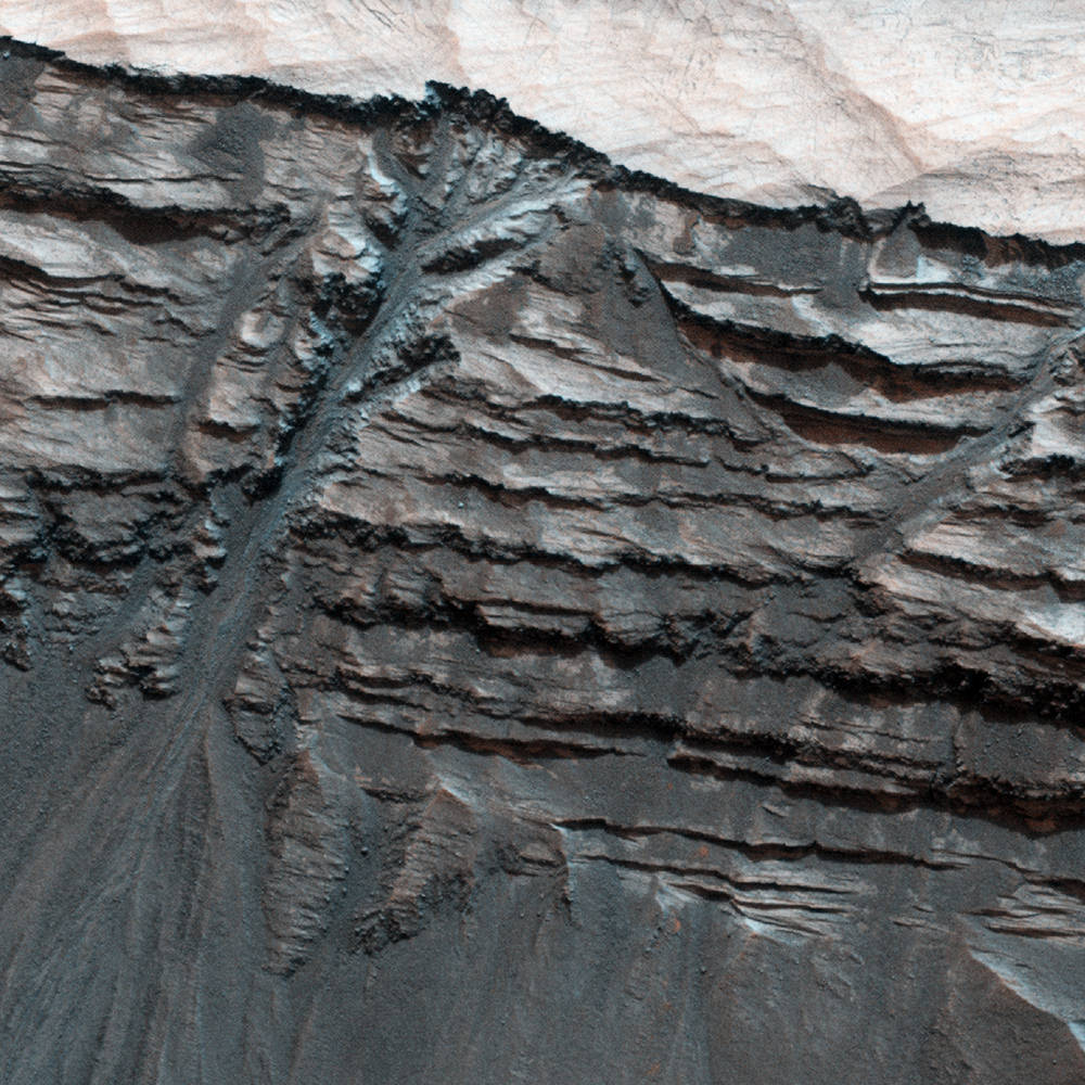
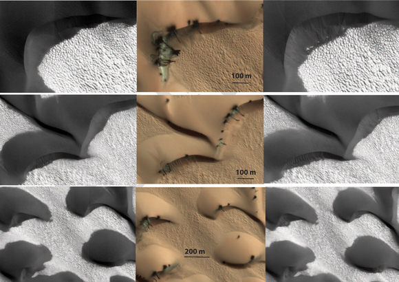
They are headed toward the surface like a speeding freight train… and running ahead of them is a shockwave. Just like a loud sound can trigger a snow avalanche here on Earth, the shockwave of a meteorite crashing through the Martian atmosphere could trigger dust avalanches on the surface before an actual impact.
According to a study led by University of Arizona undergraduate student, Kaylan Burleigh, there is sufficient photographic evidence to prove that incoming meteorites are producing enough energy to impact the surface environment just as much as the strike. Mars’ thin atmosphere also contributes, since the lesser density means most meteorites survive the trip to the surface. “We expected that some of the streaks of dust that we see on slopes are caused by seismic shaking during impact,” said Burleigh. “We were surprised to find that it rather looks like shockwaves in the air trigger the avalanches even before the impact.”

“The dark streaks represent the material exposed by the avalanches, as induced by the airblast from the impact,” Burleigh said. “I counted more than 100,000 avalanches and, after repeated counts and deleting duplicates, arrived at 64,948.”
As Burleigh took a closer look at the distribution of avalanches around the impact site, he noticed a lot of relative things, but the most important was a curved formation described as scimitars. This was a major clue as to how they were formed. “Those scimitars tipped us off that something other than seismic shaking must be causing the dust avalanches,” Burleigh said.
Just as a freight train sends a rumble before it arrives, so does the incoming meteor. By using computer modeling, the team was able to simulate how a shockwave could form and match the scimatar patterns to the HiRISE images. “We think the interference among different pressure waves lifts up the dust and sets avalanches in motion. These interference regions, and the avalanches, occur in a reproducible pattern,” Burleigh said. “We checked other impact sites and realized that when we see avalanches, we usually see two scimitars, not just one, and they both tend to be at a certain angle to each other. This pattern would be difficult to explain by seismic shaking.”
Because there are no plate tectonics, nor water erosion issues, these types of findings are very important to understanding how many Martian surface features are formed. “This is one part of a larger story about current surface activity on Mars, which we are realizing is very different than previously believed,” said Alfred McEwen, principal investigator of the HiRISE project and one of the co-authors of the study. “We must understand how Mars works today before we can correctly interpret what may have happened when the climate was different, and before we can draw comparisons to Earth.”
Original Story Source: University of Arizona News.
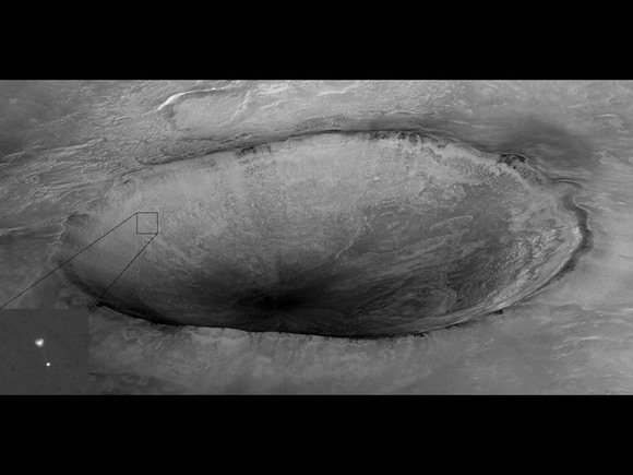
Mars Orbiters Will Attempt to Take Pictures of the Curiosity Rover as It Lands
[/caption]
Remember this amazing image from 2008? The HiRISE (High Resolution Imaging Science Experiment) camera on the Mars Reconnaissance Orbiter captured the Phoenix lander descending on a parachute to land on Mars’ north polar region. MRO will attempt a repeat performance in August of 2012 when the Mars Science Laboratory rover “Curiosity” will be landing in Gale Crater on Mars. Capturing this event would be epic, especially with MSL’s unique “skycrane” landing system.
“Yes, MRO is planning to image the descent of MSL with both HiRISE and CTX (Context Camera),” Alfred McEwen, HiRISE principal investigator told Universe Today. “For Phoenix we got a bit lucky with HiRISE in terms of the geometry, giving us a high probability of success. It may not work out so well for MSL. What I’d really like is to capture the rover hanging from the skycrane, but the timing may be difficult.”
Again, the word here is epic.
So, how challenging is it for a spacecraft orbiting Mars to try and track another spacecraft coming in?
“If we were not to do anything, the Mars’ orbiting spacecraft may be on the other side of the planet,” said MSL navigation team chief Tomas Martin-Mur, during an interview with UT. “So as soon as we launch, we tell the other spacecraft where we are going to be by the time of entry so they can change their orbits over time, so they will be flying overhead as MSL approaches the planet.”
The orbiters – which also includes NASA’s Mars Odyssey and ESA’s Mars Express – will have to do special maneuvers to be aligned in just the right place – nearby to MSL’s point of entry into Mars’ atmosphere — and they may even have to change the plane of their orbit.

“The other thing that we’ll need them to do is to point their UHF antennas towards MSL,” Martin-Mur said. “Normally their antennas will be pointed to take pictures, but they will have to go to a special attitude to point to MSL. This will enable them to try — like they did with Phoenix — to take a picture of the spacecraft as it is coming down to the planet. We are hoping to see the parachute deployed and maybe more.”
“That was a great picture for Phoenix, and we will attempt to repeat that,” Martin-Mur added.
While Odyssey and Mars Express’ cameras may not have the resolving power to capture such an image, MRO’s powerful HiRISE camera does. However it has a narrower field of view, so as much skill and planning as this requires, the team will need a little luck, too. But there’s also the CTX.
“CTX has a much larger field of view and will likely capture it,” McEwen said, “but at 20X lower resolution than HiRISE, which should still be good enough to detect the parachute.”
Here’s a preview of what MSL will be going through during the perilous entry descent and landing:
Learn more about the navigation for MSL, currently traveling on its way to Mars, in our previous interview with Tomas Martin-Mur.
MRO Spots Martian Dunes in Motion
[/caption]
The benefit of long-term observations from orbit became evident today with the release of images from NASA’s Mars Reconnaissance Orbiter showing the subtly shifting motion of large sand dunes on the red planet, proving that the surface of Mars is much more dynamic than previously believed!
The atmosphere of Mars is extremely thin – only 1% as dense as Earth’s. This means that Martian winds would seem barely perceptible to a human, and has to blow at high speeds to move even the smallest particles on its surface.
Although scientists have known that Mars contains many dunes and vast expanses of sandy regions it has been assumed that these features must move very slowly – if at all – due to the thin air.
“We used to think of the sand on Mars as relatively immobile, so these new observations are changing our whole perspective.”
– Nathan Bridges, lead author

Now, images taken at different intervals by the MRO’s HiRISE camera have been seen to clearly show the shifting motion of several large sand dune features (called bedforms) in various locations on Mars.
“Mars either has more gusts of wind than we knew about before, or the winds are capable of transporting more sand,” said Nathan Bridges, planetary scientist at the Johns Hopkins University’s Applied Physics Laboratory and lead author of a paper published online in the journal Geology. “We used to think of the sand on Mars as relatively immobile, so these new observations are changing our whole perspective.”
Sandy particles on Earth that could be moved by a 10 mph breeze would require an 80 mph gust of Martian wind. Weather data and climate models have shown that such winds should be rare on Mars; these recent findings by MRO indicate that either high-speed winds are more common than once thought or else they are more capable of moving sand around… or a combination of both!
Not all of Mars’ dunes are so restless, though. The study showed that there are regions that show no movement.
“The sand dunes where we didn’t see movement today could have larger grains, or perhaps their surface layers are cemented together,” Bridges said. “These studies show the benefit of long-term monitoring at high resolution.”
Ten years ago the belief was that dunes on Mars are either static or move too slowly to detect. Thanks to MRO and the HiRISE team – and the authors of this new paper – we now know that idea is all just dust in the wind.
Read more on the NASA MRO news release.
Image credits: NASA/JPL-Caltech/Univ. of Ariz./JHUAPL
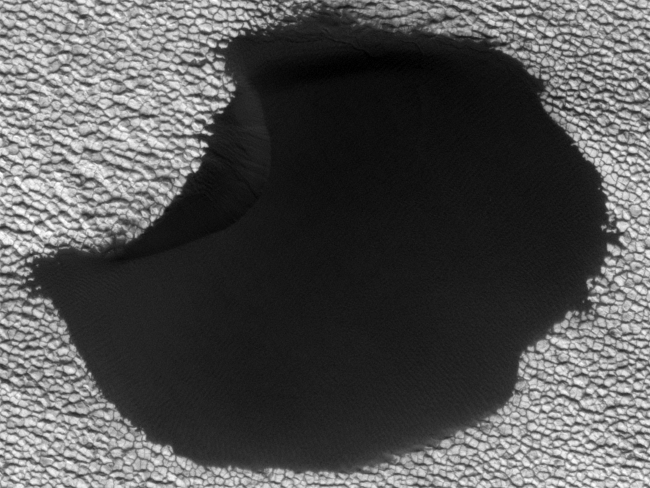
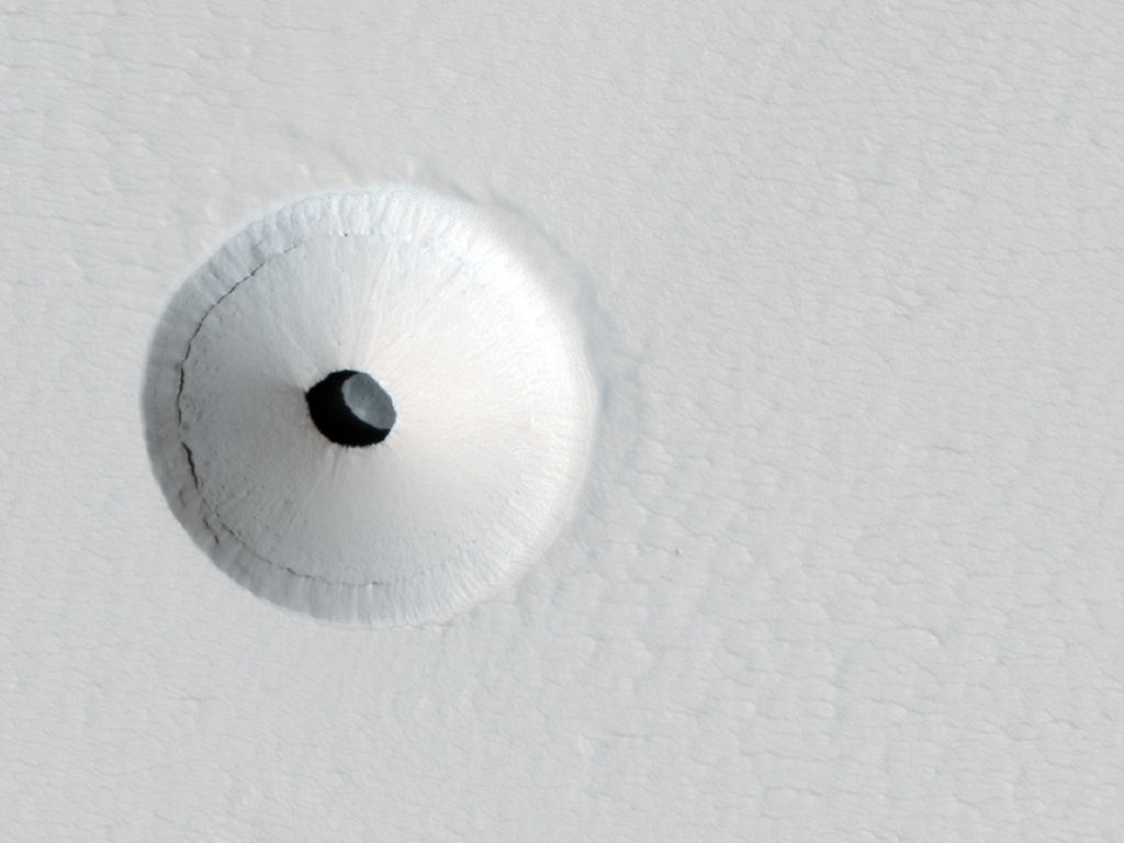
What Lies Beneath
[/caption]
What would make a great home for a giant Martian ant lion? I’d have to say this pit, imaged by the HiRISE camera aboard the Mars Reconnaissance Orbiter!
Earlier this year a crater was spotted with a dark spot at its center. When the team took a closer look with the high-resolution camera they saw that the spot is actually a 35-meter (115-foot) -wide skylight that opens into an underground cavern. The cavern is most likely a section of an empty lava tube, leftovers from ancient Martian volcanic activity.

Based on the shadows it’s estimated that the pit is about 20 meters (65 feet) deep. But, how much of that is material piled up on the floor of the cavern from the surrounding crater itself? And what caused the crater to form in the first place? These are questions that remain to be answered.
The HiRISE image itself is false-color, the hues denoting the texture and composition of the surface material and not the actual color as would be seen in visible light.
As far as a giant Martian ant lion… well, unless there are some giant Martian ants around for it to snack on, I’m going to assume there’s nobody home!
Image credit: NASA / JPL / University of Arizona.
Swirls, Gullies and Bedrock Create Two Jaw-Dropping Ethereal Mars Landscapes

[/caption]
Wow! These two latest images from the HiRISE Camera on the Mars Reconnaissance Orbiter are simply amazing. I couldn’t decide which to post on top as the lead image, so did a coin flip. This observation shows dune gullies laced with beautiful swirls of tracks left by dust devils. Just like on Earth, dust devils move across the Martian surface and expose the underlying darker material, creating a striking view. The HiRISE team has been tracking changes in this location (-70.3 degrees latitude and 178.2 degrees Longitude East), and they also compare it with dune gully activity going on in other regions. The science team says the activity here is rather anomalous for their high altitude location.
And the other image….

This HiRISE image shows a very unique butter brickle-like landscape — it is actually dunes and bedrock on the floor of a crater near Noachis Terra. What strikes me most is the clarity of the detail in this image — it is absolutely stunning.
Scientifically, this crater is unique because it has been very well characterized as being olivine-rich. Olivine is a magnesium-iron silicate that is very common on Earth. There are other regions of Mars that are also rich in olivine, and since olivine turns into other minerals in the presence of water, scientists are interested in looking for those minerals as well.
The science team says that while the large scale morphology of these craters is well characterized, this is not the case with fine scale layering and fracturing, such as what is seen here. Studying landscapes like this could help the understanding of large scale crustal processes on Mars, including the genesis of magmas and the creation of regolith.
All I know is that it is just plain pretty.
More Evidence of Liquid Erosion on Mars?
[/caption]
Terby Crater, a 170-km-wide (100-mile-wide) crater located on the northern edge of the vast Hellas Planitia basin in Mars’ southern hemisphere, is edged by variable-toned layers of sedimentary rock – possibly laid down over millennia of submersion beneath standing water. This image (false-color) from the HiRISE camera aboard the Mars Reconnaissance Orbiter shows a portion of Terby’s northern wall with what clearly looks like liquid-formed gullies slicing through the rock layers, branching from the upper levels into a main channel that flows downward, depositing a fan of material at the wall’s base.
But, looks can be deceiving…
Dry processes – especially on Mars, where large regions have been bone-dry for many millions of years – can often create the same effects on the landscape as those caused by running water. Windblown Martian sand and repetitive dry landslides can etch rock in much the same way as liquid water, given enough time. But the feature seen above in Terby seem to planetary scientists to be most likely the result of liquid erosion… especially considering that the sedimentary layers themselves seem to contain clay materials, which only form in the presence of liquid water. Is it possible that some water existed beneath Mars’ surface long after the planet’s surface dried out? Or that it’s still there? Only future exploration will tell for sure.
“While formation by liquid water is one of the proposed mechanisms for gully formation on Mars, there are others, such as gravity-driven mass-wasting (like a landslide) that don’t require the presence of liquid water. This is still an open question that scientists are actively pursuing.”
– Nicole Baugh, HiRISE Targeting Specialist
Terby Crater was once on the short list of potential landing sites for the new Mars Science Laboratory (aka Curiosity) rover but has since been removed from consideration. Still, it may one day be visited by a future robotic mission and have its gullies further explored from ground level.
Click here to see the original image on the HiRISE site.
Image credit: NASA / JPL / University of Arizona
New Color Image Shows Opportunity Rover from Orbit
[/caption]
Another great shot by the HiRISE camera on the Mars Reconnaissance Orbiter: this one of the Opportunity rover sitting on the edge of Santa Maria Crater. The High Resolution Imaging Science Experiment took this image on March 1, 2011, and also visible are the tracks in the Martian soil that Oppy created as she made her way to the crater.
“Opportunity has been studying this relatively fresh 90-meter diameter crater to better understand how crater excavation occurred during the impact and how it has been modified by weathering and erosion since,” said Matt Golombeck, a research geologist at the Jet Propulsion Laboratory, and part of the rover team. “Note the surrounding bright blocks and rays of ejecta.”
You can see a non-annotated image here. March 1 on Earth is the 2,524th Martian day, or sol, of Opportunity’s work on Mars.
By the way, MRO celebrates its 5th anniversary of being in orbit of Mars on March 10. Wow, 5 years already? But its been 5 years of great images and discoveries, with wishes from all of us for many more!
Ken Kremer has put together a couple of collection of images that Opportunity has taken while at Santa Maria, some that he and others from Unmanned Spaceflight.com have processed and enhanced for sharper, colored views — this article contains several awesome panoramas, and here’s a collection of 3-D images.
Source: HiRISE website
Active Changes Occuring in Mars’ Northern Hemisphere
[/caption]
Mars, it is a-changin’, and more than scientists expected. Several series of before-and-after images taken by the HiRISE camera on the Mars Reconnaissance Orbiter the past two years show sand dunes in Mars northern hemisphere changing – both gradually and suddenly. A team of researchers analyzing the images say that the changes have been caused mostly by sand and ice cascading down the slipfaces of the dunes. But, also, there could be “alien” processes that we don’t see occurring on Earth.
“The numbers and magnitude of the changes have been really surprising,” said HiRISE Deputy Principal Investigator Candice Hansen.
 and experienced sublimation activity (middle), which resulted in the new alcove and fan (with total length of 120 m) in MY30. The layer of new material forming the apron is very thin; the original ripples have not been completely buried. Image courtesy Science/AAAS.")
In the past, Mars was thought to be a dead world, frozen in time with not many changes taking place on its surface. But since the arrival of high-resolution cameras orbiting the Red Planet – first on the Mars Global Surveyor, and now on MRO and ESA’s Mars Express – that notion has fallen by the wayside. Avalanches, new gullies and now shifting sand dunes are appearing regularly on images from Mars.
Even with the known winds on Mars, scientists had considered the dunes to be fairly static, shaped long ago when winds on the planet’s surface were thought to be much stronger than they are today.
Hansen and her colleagues’ new paper that is published in this week’s edition of the journal Science identifies the seasonal changes from a layer of frozen carbon dioxide – a.k.a or dry ice – which covers the region in winter and sublimates away in the spring, along with stronger-than-expected gusts of wind as initiating sand transport on the northern dunes of Mars.

“This gas flow destabilizes the sand on Mars’ sand dunes, causing sand avalanches and creating new alcoves, gullies and sand aprons on Martian dunes,” Hansen said. “The level of erosion in just one Mars year was really astonishing. In some places hundreds of cubic yards of sand have avalanched down the face of the dunes.”
Recently, scientists have seen how the scars of past sand avalanches could be partially erased in just one Mars year. Models of Mars’ atmosphere do not predict wind speeds adequate to lift sand grains, and data from Mars landers such as Phoenix show high winds are a rare occurrence.
“Perhaps polar weather is more conducive to high wind speeds,” Hansen said.

The researchers say changes were seen in about 40 percent of far-northern monitoring locations over the two-Mars-year period of the study.
Related research with HiRISE previously identified gully-cutting activity in smaller fields of sand dunes covered by seasonal carbon-dioxide ice in Mars’ southern hemisphere. A report four months ago showed that those changes coincided with the time of year when ice builds up.
, shown in this image. When the sun rises in the spring the ice begins to sublimate. Gas flow from the bottom of the ice layer propels sand from the dunes out through cracks to the top of the ice and down the dune slipface. Image courtesy of NASA/JPL/University of Arizona")
“The role of the carbon-dioxide ice is getting clearer,” said Serina Diniega of NASA’s Jet Propulsion Laboratory, Pasadena, Calif., lead author of the earlier report and a co-author of the new report. “In the south, we saw before-and-after changes and connected the timing with the carbon-dioxide ice. In the north, we’re seeing more of the process of the seasonal changes and adding more evidence linking gully activity with the carbon dioxide.”
“Understanding how Mars is changing today is a key first step to understanding basic planetary processes and how Mars changes over time,” said HiRISE Principal Investigator Alfred McEwen, a co-author of both reports. “There’s lots of current activity in areas covered by seasonal carbon-dioxide frost, a process we don’t see on Earth. It’s important to understand the current effects of this unfamiliar process so we don’t falsely associate them with different conditions in the past.”
Source: Science
Spots Among Spots on Mars
[/caption]
This unusual landscape on Mars can be found within a crater on the southern hemisphere of the Red Planet. But if you look on the actual location of this HiRISE image on the Google Map of Mars, below, you’ll see these spots are just spots among spots.
")
Seasonal spots appear on dunes found on the floors of craters on Mars; most likely it is from carbon dioxide frost that is “defrosting” and later may sublimate away. At one time, these spots that seemingly come and go with the seasons were thought to be signs of life on Mars. The jury is still out on that line of thinking.
See the original picture on the HiRISE website and zoom around the Google Mars (below the image on the HiRISE site) to see the entire area, or go to Google Mars.