
The folks from the HiRISE Camera on the Mars Reconnaissance Orbiter have put together a video with some groovin’ music of the latest images from the Red Planet, courtesy of HiRISE, the bestest camera in all of Marsdom. There’s an elliptical impact crater, giant gullies, sinuous ridges and a Swiss Cheese smiley face. No foolin’!
Latest From Mars: Frosty Landscapes, Ancient Lakebed, Potential Landing Site

A new batch of images has been released by the HiRISE camera on the Mars Reconnaissaince Orbiter and –as usual — they are stunning. In the image above, there is a lot going on! Numerous dust devil tracks have left their criss-crossing marks on the dune field found in Richardson Crater. The dunes are covered by seasonal carbon dioxide frost, which has only partially defrosted, although the image was acquired late in Mars’ southern spring. There are channels carved into the ground and HiRISE scientists says the could have been created by blocks of carbon dioxide ice (dry ice) slide down the slope and sublimate (evaporate directly from solid to gas). Wouldn’t that be fun to be there and watch happen!
See more of the “coolest” and latest Mars images from HiRISE below:
Continue reading “Latest From Mars: Frosty Landscapes, Ancient Lakebed, Potential Landing Site”
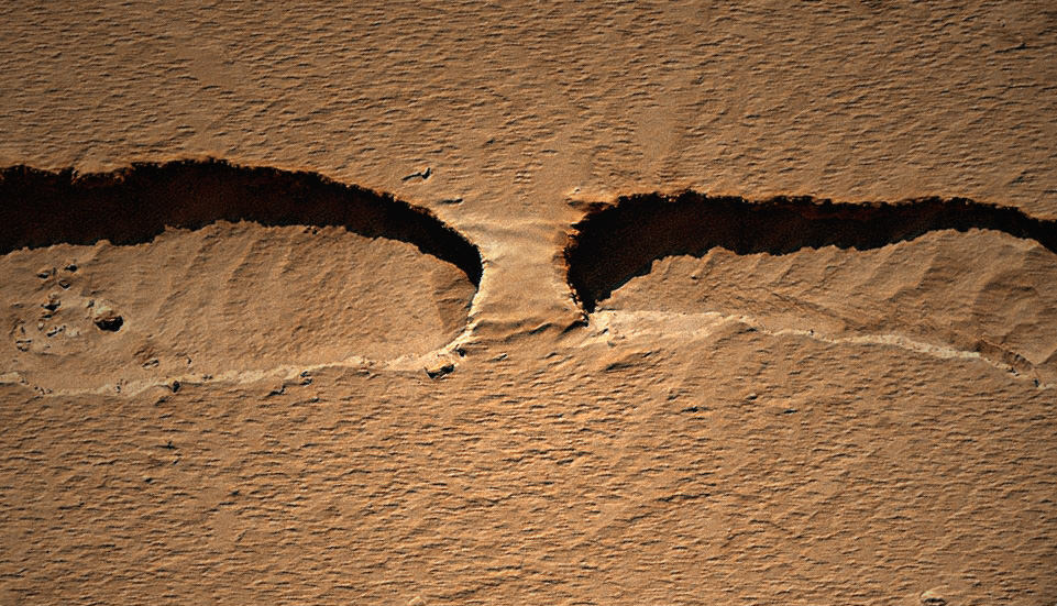
Rock Bridge on Mars
[/caption]
The HiRISE camera on the Mars Reconnaissance Orbiter took an image of a thin channel, and a portion of it contains a naturally occurring bridge over the chasm. Kelly Kolb from the HiRISE team says it is probably a remnant of the original surface, the rest of which has collapsed downward. It isn’t likely there’s a opening underneath the formation, but if there were, it would look very similar to a rock bridge formation found in Jordan in the Wadi Rum, the Valley of the Moon. See an image below.
Kolb also said this is unlikely to be a channel formed by a running water, as there are no obvious source or deposit regions. The channel is probably a just a collapse feature.
And see the full HiRISE image of the thin channel, found in Mars northern hemisphere between some “knobs” called Tartarus Colles, below.


For more information about this image on Mars, see the HiRISE website.
Carbon Dioxide — Not Water — Creating Gullies on Mars, New Study Says
[/caption]
Intriguing images of brand new, fresh gullies on Mars has most of us thinking of one thing: water. But at least for one type of Mars gully, carbon dioxide frost is the impetus behind fresh flows showing up on images from orbiting spacecraft.
“Gullies that look like this on Earth are caused by flowing water, but Mars is a different planet with its own mysteries,” said Serina Diniega, author of a new paper published in the journal Geology. “The timing we see points to carbon dioxide, and if the mechanism is linked to carbon-dioxide frost at these dune gullies, the same could be true for other gullies on Mars.”
Scientists have seen evidence of fresh gullies on Mars, beginning 2000 with images from the Mars Global Surveyor. Different mechanisms were proposed including water and carbon dioxide, as well as other forces.
On the HiRISE website, searching for “gullies” provides a bounty of images. Some fresh gullies are on sand dunes, commonly starting at a crest. Others are on rockier slopes, such as the inner walls of craters, sometimes starting partway down the slope.
 Active Dune Gullies in Kaiser Crater. Credit: NASA/JPL/University of Arizona")
While a graduate student at the University of Arizona, Tucson, Diniega tracked changes in gullies on faces of sand dunes in seven locations on southern Mars. In looking at before-and-after images, in all cases, the gullies appeared after the known winter build-up of carbon-dioxide frost on the dunes. Before-and-after images that looked at periods in spring, summer and autumn showed no new activity.
Because new flows in these gullies apparently occured in winter, rather than at a time when any frozen water might be most likely to melt, Diniega and co-authors at the University of Arizona and Johns Hopkins University Applied Physics Laboratory believe they found evidence that carbon dioxide, rather than water, were responsible for the flows. Some carbon dioxide from the Martian atmosphere freezes on the ground during winter and sublimates back to gaseous form as spring approaches.

“One possibility is that a pile of carbon-dioxide frost accumulating on a dune gets thick enough to avalanche down and drag other material with it,” Diniega said. Other suggested mechanisms are that gas from sublimating frost could lubricate a flow of dry sand or erupt in puffs energetic enough to trigger slides.
The team focused their study on dune gullies that are shaped like rockier slope gullies, with an alcove at the top, a channel or multiple channels in the middle, and an apron at the bottom. The 18 dune gullies in which the researchers observed new activity range in size from about 50 meters or yards long to more than 3 kilometers (2 miles) long.
Source: JPL
More Recent Landslides Spotted on Mars
[/caption]
Thanks to the Mars Reconnaisance Orbiter and the on-board HiRISE camera, scientists are able to monitor Mars for changes taking place on the landscape. They do this by comparing older images with newer ones, and also by seeing “fresh” features — like this recent landslide in Zunil Crater. “The color and albedo patterns indicate that a landslide occurred here very recently–too recently to have been re-covered by dust,” writes Alfred McEwen, principal investigator of HiRISE, writing on the camera’s website. “Looking for changes such as this will help us to better understand active processes.” McEwen said the landslide could have been triggered by a Marsquake or a small impact event.”
See more recent landslides below:

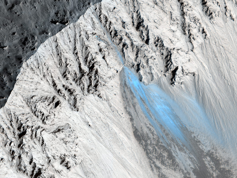
Our ‘eagle-eyed’ pal Stuart Atkinson found this landslide on a steep scarp in the north polar region. It looks as though a lot of rock has fallen from the cliff, and discussion among other image artists on UnmannedSpaceflight.com indicated that the blue areas could easily be patches of ice deposited from the cliff face. You can see the original image at the HiRISE website.

This image is so amazing, in that from orbit, we are looking down the side of a crater wall, where gullies have formed. There are two schools of thought on these types of gullies: one, many scientists believe that these gullies have been carved by liquid water, and were carved recently, so this recent, present-day activity is of immense interest.
A second opinion is that accumulations of frost in the gully alcoves starts an avalanche of loose material that does not involve liquid water. The MRO scientists will continue to analyze many images like this in order to try and answer the broader question of whether liquid water is responsible for the the gullies, landslides and avalanches or not.

This image of Bahram Vallis has large mounds of material at the base of the valley floor. These deposits of material have the characteristic shape of rotational landslides or slumps on Earth where material along the entire wall slumps down and piles debris at the base of the slope, “much like a person who slumps down the back of a chair,” writes Frank Chuang from the HiRISE team. “Right at the cliff edge at the top of the slope, the shape of the area where the valley wall gave way to a landslide is not straight, but rather curved or semi-circular. This is typical of large landslides where the failure area has an arcuate “crown” shape. The fact that landslides have occurred here indicates that the valley walls are not stable and the materials respond to Martian gravity with mass movements.”
Latest from Mars: Exposed Ice in Fresh Crater, Plus 100’s More New Images
[/caption]
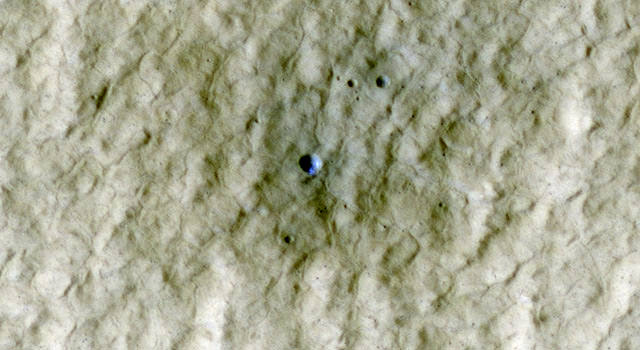
Mars-o-philes rejoice! New images from Mars galore, including this “after” image of Mars’ northern hemisphere which reveals a new crater was created sometime between April 2004 and January 2010. Intriguingly, scientists believe exposed ice is visible in this new image from the HiRISE camera. This is just one of the latest release of hundreds of high-resolution HiRISE images, so go get your fill of Mars at the HiRISE site. But what about that ice?
The crater is at a latitude of 44 degrees North and is itself located on the ejecta of a larger crater. The image was acquired in early summer, when frost at this latitude is not expected. That’s why the HiRISE science team believes the bright blue material in this false-color color image is sub-surface ice that was exposed by the impact.
This ice is probably at the same depth and has a similar origin to that excavated by the Phoenix lander back in 2008. The area of exposed ice based on the HiRISE images is about 1-2 square meters (10-20 square feet.
An intriguing image, and a great example of the treasures available in this newest release of images from Mars.
For more images, see the HiRISE website.
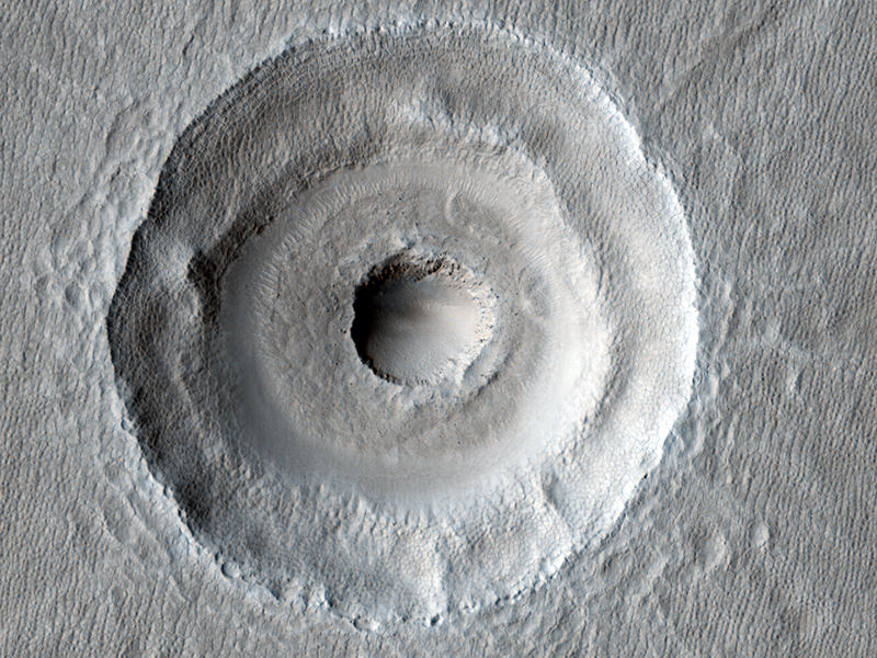
Bulls-Eye on Mars and, Apparently, an Industrial Complex
[/caption]
Here’s some doses of coolness and craziness for your Friday. This top image is one of the latest from the HiRISE camera on the Mars Reconnaissance Orbiter, and shows what looks like a target on the Red Planet. Researchers from the HiRISE team aren’t sure yet whether this is two impacts — one impact that occurred dead center within another — or just unusual subsurface layering within one impact. I’m voting for two impacts, just because it is such a cool, lightning-strikes-twice concept. While no ejecta from the interior crater can be seen, the team says the ejecta could have been removed by extensive periglacial modification. Additionally, the floor fill around the inner crater resembles impact ejects elsewhere at this latitude, and some of the “landslides” to the East could be flow-back of ejecta off the walls of the larger crater. Likely the team will be looking closer at this impact to sort out the history and likelihood of a double impact. (UPDATE: I just saw that the Bad Astronomer has posted a more detailed CSI into this image, which you should read!)
Now, this next one is the crazy part…
 nozzle spray and (b,c) domes. Credit: NASA, annotations from Farsight Institute, via the SciGuy.")
There’s a guy, and apparently a team of “remote viewing experts” who have found what they believe is a massive industrial complex on Mars. Eric Berger at his SciGuy blog at the Houston Chronicle wrote about this today, and it is just way too wacky to believe, kind of like the people who zoom in on rocks on Mars and say they see Bigfoot. Anyway, these folks say they can even tell that there are artificial structures at this site with a laboratory. What’s more they can see that there are lifeforms there wearing uniforms, and there are more men than women. Yep.
Get Your Mars (and HiRISE) Fix With Over 600 New Images
[/caption]
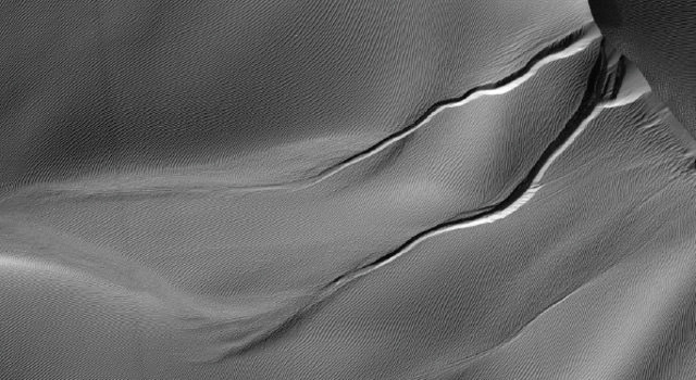
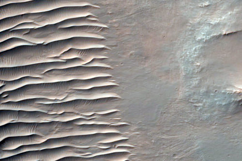
Mmmm, Mars. And lots of it, too! The team from one of our all-time favorite scientific instruments, the HiRISE camera on the Mars Reconnaissance Orbiter has just released a big batch of images taken from April 5 to May 6, 2010, and they are now available on NASA’s Planetary Data System and on the HiRISE website. This includes over six hundred recent observations of the Mars landscape as seen from orbit, including scenes of sinuous gullies, geometrical ridges, steep cliffs, or these unusual dunes, above, in Desher Vallis.
Each of the 629 new images cover an area of several square miles on Mars and reveals details as small as desks.

HiRISE is made of awesome, and is one of six instruments on MRO,which reached Mars in 2006.
Source: JPL
Latest Mars Avalanche Likely Triggered by Impact Event

[/caption]
The HiRISE team from the Mars Reconnaissance Orbiter has captured a few avalanches on Mars, some actually while in progress. But this latest landslide is a little different. Above is a dust avalanche that created a streak on the slopes of Olympus Mons, the solar system’s largest volcano. While scientists believe some of the previous avalanches seen on Mars occur due to the expansion and contraction of ice from seasonal temperature differences, this one was caused by an impact event. This HiRISE image was taken on March 31, 2010 and reveals a small, pristine impact crater (blue arrow). “It shows a fuzzy source area, which resembles the airblast patterns seen at many other recent impact sites,” said Alfred McEwen, Principal Investigator for HiRISE. “The crater is only about 4.5 meters across, meaning the bolide was only about a half a meter wide, so it didn’t take much to trigger this landslide.”

MRO’s Context Camera (CTX) took an image of this area on Nov. 18, 2007 (left) and the adjacent image on Feb. 14, 2010, which shows a large new avalanche. HiRISE then took the follow-up image in March. McEwen said slope streaks , or dust avalanches are common on Mars, but this one is unusually wide and began from an unusual extended or “fuzzy” source area. This made HiRISE team conclude that an impact event occurred sometime between the dates of the CTX images and triggered the large dust avalanche.
“Sometimes, these dust avalanches are easily triggered,” McEwen told Universe Today. “We’ve seen them caused just by dust devils. The dark area was created by an atmospheric blast associated with the impact event, with the bolide coming in at about 10 km per second that distributes the dust. You can see that the upper most fresh dust on the surface is bright, so this landslide disturbed either bare substrate or compacted, older dust.

Planetary scientists say that landslides or avalanches on Mars can also be caused by small Mars-quakes or the sublimation of carbon dioxide frost which dislodges rocks.
Sources: HiRISE, phone conversation with Alfred McEwen.
MRO Sees Opportunity on the Edge of Concepcion Crater (and more!)
[/caption]
It has been a while since I’ve posted a batch of new images from the Mars Reconnaissance Orbiter HiRISE camera, and what a treat when I saw what had just been released! This image shows the Mars Exploration Rover Opportunity perched on the edge of Concepción Crater in Meridiani Planum, Mars. This image was taken by HiRISE on February 13, 2010, on sol 2153 of Opportunity’s mission on Mars. If you look closely, you can see rover tracks in the ripples to the north and northwest of the rover! Wow! See below for a wonderful colorized close-up version by Stu Atkinson that shows the tracks very clearly. Scientists use these high-resolution images (about 25 cm/pixel) to help navigate the rover. In addition, rover exploration of areas covered by such high-resolution images provides “ground truth” for the orbital data. Oppy has moved along from Concepcion and is now heading towards a set of twin craters. You can check out Stu’s blog Road to Endeavour to see what Opportunity is seeing these days. One milestone (meterstone?) Oppy recently reached was hitting 20 km on her odometer and she seems to continue to be in great operating condition. Go Opportunity! Click here to be able to download larger versions of the image.


This image is interesting because of all the interesting different aspects you can find if you look closely. The surface must be relatively young because there are no recent impact craters. There are numerous dust devil tracks crisscrossing across the image. Plus, there are polygon features in the soil – the same features seen around the Phoenix lander area which are produced by repeated expansion and contraction of the soil-ice mixture due to seasonal temperature changes. This is the Vastitas Borealis region on Mars’ northern plains.
Another interesting feature is the circle of boulders that appears on the right side. Is there an impact crater buried under shifting Martian sand? A visit by a rover or human could tell us for sure.
The image covers approximately 400 x 250 meters (350 x 225 yards).
 Layers and Dark Debris in Melas Chasma Credit: NASA/JPL/University of Arizona")
This is an impressive looking region in Melas Chasma. Scientists say the layers are sedimentary in origin, but there are many processes that could have deposited them, such as volcanic airfall from explosive eruptions, or dust-size particles settling out of the atmosphere due to cyclic changes, and deposition in standing bodies of water.
See more great images at the HiRISE website.