Stunning New Looks at the Mars Avalanche

A single-image photoclinometric 3D reconstruction of the Mars avalanche from HiRISE. Image data: NASA/JPL/UA; 3D model: Bernhard Braun

[/caption]

Remember the amazing image of an avalanche on Mars back in 2008, captured by the HiRISE camera on the Mars Reconnaissance Orbiter? Bernhard Braun from UnmannedSpaceflight.com has now created several different 3-D views of the event, providing never-seen-before, ground-level observations by using special software he developed that can create three dimensional images from one 2-dimensional picture. Normally, to create a 3-D image you need at least two images, or you have to combine images with data from an instrument such as a laser altimeter. But Braun’s single-image photoclinometric 3D reconstruction algorithm, also known as “shape from shading” allows the shape of three dimensional objects to be recovered from shading in a two-dimensional image. Braun told Universe Today that since developing the software, one of the areas he has wanted to “visit from the ground” is the famous dust avalanche caught live in action by HiRISE. His images provide an entirely new — and stunning — view of Mars.

A single-image photoclinometric 3D reconstruction of the Mars avalanche from HiRISE. Image data: NASA/JPL/UA; 3D model: Bernhard Braun

Braun said that the software is useful to look at various areas of interest, in particular where we have no other (i.e stereo-imaging based) detailed 3D reconstructions yet. Previously, we’ve shown 3-D movies on Universe Today that Doug Ellision and others from UnmannedSpaceflight.com have created from HiRISE DEMs (Digitial Elevation Models) which are a grid, or raster file describing elevation values at regularly spaced points, or posts. HiRISE DEMs are made from two high-resolution images of the same area, taken from different look angles by the spacecraft. The HiRISE folks say that creating a DEM is complicated and involves sophisticated software and a lot of time, both computing time and man-hours.

But Braun’s software (although it took him quite some time to develop) allows for a moderate processing time, about 15 minutes per medium-resolution image, using about 2 gigabytes of memory. Also, no texturing or additional coloring/shading was applied when rendering the surface, and every detail visible is real 3D down to the pixel-level.

But, Braun doesn’t think his method is in any way “superior” to the HiRISE team’s efforts.

“Quite to the contrary,” he told me via email. “Traditionally, single-image shape-from-shading methods like the one that I developed, are considered to nicely complement the multi-image (stereo) methods because the weaknesses of one method (large scale distortions in single-image-methods vs. less detail resolution in multi-image methods ) is the strength of the other. Also, the official HiRISE DEMs are generally more accurate at exactly reproducing absolute terrain heights (also using altimeter-based calibration), which is important for scientific usage, whereas my DEMs are less well calibrated because they are mainly intended for visualization purposes.”

The main advantage of the single-image method is that it can be used on almost arbitrary images of areas where there isn’t 3D coverage yet, such as capturing an event like an avalanche.

“In a way, it opens the door to an entirely new view of large existing 2D-only data sets, Braun said. “For example, currently I am working on an extension of the method to radar images for hi-resolution 3D reconstructions of the highest-resolution Venus Magellan data sets.”

Braun’s software method could be considered more of an art form.

“I view my software and algorithms not so much as a scientific measuring instrument,” Braun told me in an email, “but more as a tool for visualization that leaves a bit of artistic license, a degree in freedom of interpretation i.e. the means for creating atmospheric images and it is those images that are the real “publishable end product” of the whole process. The algorithms and software are just the ‘painters brush and easel’ or the photographer’s virtual camera so to speak.”

Another single-image photoclinometric 3D reconstruction of the Mars avalanche from HiRISE. Image data: NASA/JPL/UA; 3D model: Bernhard Braun

Emily Lakdawalla did a wonderful job of explaining the whys and hows of the entire process in the Planetary Society Blog: (go there if you’d like a more detailed description) “Imagine a crumpled piece of paper lit by a spotlight. Facets of the crumpled paper that are perpendicular to the spotlight will appear brightest; facets tilted away from the spotlight will appear dark. If you assume that everything in the picture reflects light in the same way, then you can tell by its albedo, or brightness, whether it is tilted toward or away from the light source. ”
A Mars Avalanche, taken by NASAs HiRISE instrument on the Mars Reconnaisance Orbiter (Credit: NASA/HiRISE)

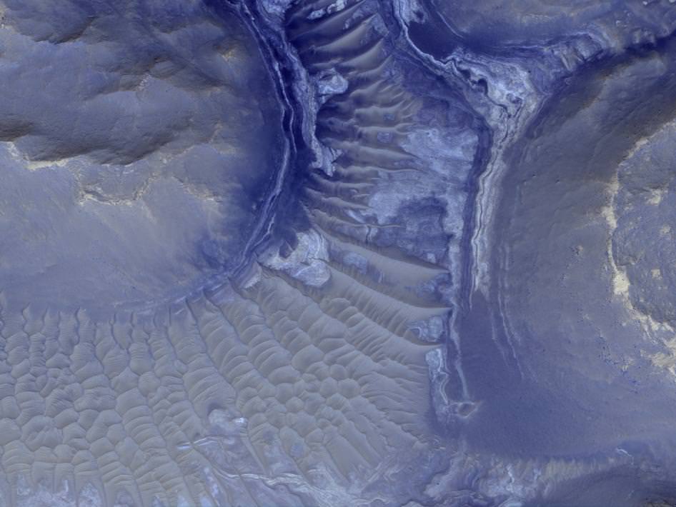
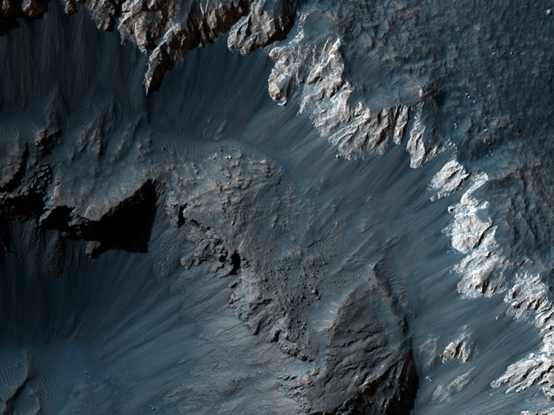
Above is the original image from HiRISE. When looking at these images, remember that this particular scarp on Mars is a high cliff over 700 m (2300 ft) tall and slopes at over 60 degrees. A mixture of ice, rock and dust can be seen, frozen in time, as it is plummeting down the slope, ejecting a plume of dust as the debris begins to settle on the gentle slope at the bottom of the cliff. The ejected cloud is approximately 180 meters across and extends about 190 meters beyond the base of the cliff.

Braun told us he is working on some new images which we hope to be able to share with you soon, and we extend our thanks to him for allowing us to post the avalanche images on Universe Today.

Follow this link to look at Braun’s entire gallery of wonderful color 3D renderings of the avalanche, derived from the originally published HiRISE image, rendered under various viewing positions and light source directions.

New Amazing Mars Flyover Videos


Doug Ellison from UnmannedSpaceflight.com has done it again… and again… and again. Here are new Mars flyover videos Doug has created from data from the HiRISE camera on the Mars Reconnaissance Orbiter. Using DEM (Digital Elevation Model)– (also known as DTM Digital Terrain Model) files provided by the HiRISE team, Doug is able to render 3-D movies of a specific location on Mars. Since he is using actual high-resolution data from HiRISE, Doug says the terrain seen in the movies has accurate vertical scaling and is not exaggerated. These new views of the Red Planet are also stunningly beautiful! The video above is of the Mojave Crater wall on Mars, and below is Athabasca Valles. And Doug says more are on the way! If you recall, Doug created the flyover video of the Spirit rover’s location that was on Astronomy Picture of the Day.
Continue reading “New Amazing Mars Flyover Videos”

HiRISE Makes Your Wishes Comes True

Possible future landing site on Mars. Credit: NASA/JPL/University of Arizona

[/caption]
The HiRISE science team is now taking requests! A new web tool called HiWish is now available for the high-resolution camera on the Mars Reconnaissance Orbiter which allows the public to suggest a location on Mars where the HiRISE instrument should take an image. If you don’t have a particular location, you can use the HiWish site to browse around the planet, examine the locations of other data sets, and find a place that should be imaged. The team will then put into their targeting database, and your suggestion may get selected as an upcoming observation. Furthermore, the HiWish site allows you to track your suggestions and be notified when one of your suggestions gets taken.

Maybe you could even find a really unusual feature on Mars, such as this race-track-like feature that may one day be a landing site for a future mission to the Red Planet. HiRISE images will help determine if this spot is sufficiently safe for landing, such as not too many boulders, steep slopes, or too many high speed MASCAR races — (that’s the Mars Association for Super Cool Aerodynamical Racing). If it is safe, it may be considered for the 2011 Mars Science Laboratory or the 2018 rovers that ESA and NASA are working on for a join mission.

The above image is actually a huge shield volcano in the northeast part of Syrtis Major, and near the Northwest rim of Isidis Planitia, a giant impact basin.

So, go create an account at HiWish and get wishing!

Stunning New Views From HiRISE; Plus Big Announcement?

Caption: Dune symmetry on Mars. Credit: NASA/JPL/University of Arizona

It is so wonderful to see the Mars Reconnaissance Orbiter back in action, especially our favorite camera, the High-Resolution Imaging Science Experiment, or HiRISE. The HiRISE team released some of their latest images this week, and they are particularly stunning, including this one of symmetrical dunes in a small crater in Noachis Terra, west of the giant Hellas impact basin. Alfred McEwan, from the HiRISE team and the University of Arizona says the dunes here are linear, and are thought to be created due to shifting wind directions. In places, each dune is remarkably similar to adjacent dunes. The linear dune fields on Mars are similar to the ones seen on Titan, although not quite as large. The debris between the dunes are large boulders.

More images below, but on another note, HiRISE Twitter notes there will be a “big announcement” on Wednesday, January 20. A major discovery? Mission extension? Website redesign? Stay tuned.

This jaw-dropping beauty accompanied a press release announcing that 21 articles from HiRISE made up the entire contents of a special January issue of the journal Icarus . The papers analyzed Martian landforms shaped by winds, water, lava flow, seasonal icing and more.

This view shows color variations in bright layered deposits on a plateau near Juventae Chasma in the Valles Marineris region of Mars.


Contortions on the floor of Hellas Basin. Credit: NASA/JPL/University of Arizona

This almost looks like etchings on Mars’ surface, and they are very strange landforms indeed. McEwan notes that materials appear to have flowed in a viscous manner, like ice, here on the floor of Hellas Basin. Viscous flow features are common over the middle latitudes of Mars, but those in Hellas are especially unique, for unknown reasons.

Frost covered dunes. Credit: NASA/JPL/University of Arizona

This is a beautiful shot of frost covered dunes inside a crater. The HiRISE team says that on the floor of this crater where there are no dunes, the ice forms an uninterrupted layer. On the dunes however, dark streaks form as surface material from below the ice is mobilized and deposited on top of the ice. In some cases this mobile material probably slides down the steep face of the dune, while in other cases it may be literally blown out in a process of gas release similar to removing a cork from a champagne bottle.


Recent impact crater. Credit: NASA/JPL/University of Arizona

This impact crater could be relatively new, as it does not appear in images taken by the Viking Orbiters in 1976. McEwan said the HiRISE team suspects that the crater is more than several decades old, however, “because at full resolution we see a textured surface that is common in dust-mantled regions of Mars, but absent in the youngest craters.” While it could have been created recently, the other explanation is that there may have been more dust on the surface in 1976 or the air may have been hazy, obscuring the crater.

Click on each of the images for access to the higher resolution versions, or go directly to the HiRISE website.

Amazing and Marvelous Mars Dunes

Sand dunes on Mars from MRO's HiRISE camera. Credit: NASA/JPL University of Arizona

[/caption]
I see the Bad Astronomer has beat me to the punch by posting this image before I could. But what an amazing and gorgeous image of dunes on Mars! However, my initial thought when I saw this on the HiRISE webpage was perhaps this was the first long-awaited look at Phil’s tattoo. Seriously, doesn’t this look like it could be body art? The dunes even have a Phil-like flesh color. But this wonderful image was taken by the HiRISE camera on the Mars Reconnaissance Orbiter. There is a great database of dune images gathered for the US Geological Survey on the HiRISE website, and below, take a gander at more lovely dune images:

Click on each image to learn more from the HiRISE website.

More Martian dunes from HiRISE.
Russell Crater dunes. Credit: Credit: NASA/JPL/University of Arizona
Dunes in the Western Nereidum Montes. Credit: NASA/JPL University of Arizona
Sand dunes. Credit: NASA/JPL/University of Arizona
Dark dunes.  Credit: NASA/JPL/University of Arizona
Dark dunes. Credit: NASA/JPL/University of Arizona

Check out the HiRISE website for more great images from Mars!

Why We All Love HiRISE

Noctis Labyrinthus on Mars. Image Credit: NASA/JPL-Caltech/University of Arizona . Click for larger version.

[/caption]
My description of this image: “Holy moly — what a gorgeous shot!” NASA’s description of this image: “Layers in the lower portion of two neighboring buttes within the Noctis Labyrinthus formation on Mars are visible in this image from the High Resolution Imaging Science Experiment (HiRISE) camera on NASA’s Mars Reconnaissance Orbiter.”

Absolutely beautiful. Click the image for access to larger versions. ‘Nuf said.

HiRISE Highlights: Crater Within a Crater, Awesome View of Victoria and More

Interesting Crater in Meridiani Planum. Credit: NASA/JPL/University of Arizona

[/caption]
I was just thinking it had been awhile since we featured images from the HiRISE camera onboard the Mars Reconnaissance Orbiter spacecraft, so I moseyed over to the HiRISE website only to be blown away by their newest releases. This incredible crater in Meridiani Planum shows a possible double whammy of impacts. It looks as though material filled in the original crater only to be blown out a second time. Another option is that the material in the crater could have collapsed, giving the appearance of a second impact. You can bet the HiRISE team will be looking more closely at this one. Before we move on to more great images, an update on MRO, which unexpectedly went into “safe” mode last week: MRO has now been restored to full operations, after switching to its backup computer. Engineers successfully transitioned the orbiter out of limited-activity “safe” mode on Saturday, Aug. 8, and resumed use of the spacecraft’s science instruments on Monday, Aug. 10. This has happened a few times, and engineers are trying to figure out the root cause of this.

Now, on to the images!
Continue reading “HiRISE Highlights: Crater Within a Crater, Awesome View of Victoria and More”

Landforms Indicate “Recent” Warm Weather on Mars

Retrogressive scarps with cuspate niches, long branching spurs and associated fluvial-like tributary channels. Credit:NASA/JPL/UofA

[/caption]
Remember the polygon-shaped landforms at Mars north polar region that the Phoenix lander studied? The polygons are produced by seasonal expansion and contraction of ground ice, and these shapes have been found in other regions on Mars as well. New studies of images from the HiRISE camera on the Mars Reconnaissance Orbiter indicates that the Martian surface near the equator experienced freeze-thaw cycles as recently as 2 million years ago. This means Mars had significantly warmer weather in its recent past, and has not been locked in permafrost conditions for billions of years as had been previously thought.

The HiRISE images show polygon-patterned surfaces, branched channels, blocky debris and mound/cone structures.

Dr. Matthew Balme, from The Open University, made the new discovery by studying detailed images of equatorial landforms that formed by melting of ice-rich soils, such as the polygons, branched channels, blocky debris and mound/cone structures. These are all found in an outflow channel, thought to have been active as recently as 2 million to 8 million years ago. Since the landforms exist within, and cut across, the pre-existing features of the channel, this suggests that they, too, were created within this timeframe.

Full resolution view of domed polygons from HiRISE.  Credit: NASA/JPL/U of A
Full resolution view of domed polygons from HiRISE. Credit: NASA/JPL/U of A

All of these features are similar to landforms on Earth typical of areas where permafrost terrain is melting.

“The features of this terrain were previously interpreted to be the result of volcanic processes,” said Balme. “The amazingly detailed images from HiRISE show that the features are instead caused by the expansion and contraction of ice, and by thawing of ice-rich ground. This all suggests a very different climate to what we see today.”

This also means as the shorter the time period since the last warm weather on the planet, the better the chance that any organisms that may have lived in warmer times are still alive under the planet’s surface.

“These observations demonstrate not only that there was ice near the Martian equator in the last few million years, but also that the ice melted to form liquid water and then refroze,” said Balme. “And this probably happened for many cycles. Given that liquid water seems to be essential for life, these kinds of environments could be a great place to look for evidence of past life on Mars.”

Source: STFC

Looking for (Former) Lakeshore Property? HiRISE Finds It on Mars

This is reconstructed landscape showing the Shalbatana lake on Mars as it may have looked roughly 3.4 billion years ago. Data used in reconstruction are from NASA and the European Space Agency. Credit: Image credit: G. Di Achille, University of Colorado

[/caption]
If you’re in the market for some remote lakeshore property where you can get away from it all, this might be just what you’re looking for. Located in a secluded, pristine setting, this must-see property might be one of a kind. It’s very remote; – did I mention this lakeshore is on Mars? And, oh — it happens to be a former lakeshore.

While lakeshore property on Mars might sound like the biggest real estate swindle ever, the news of the first definitive lakeshore on Mars is momentous. Using images from the HiRISE Camera on the Mars Reconnaissance Orbiter, a University of Colorado at Boulder research team has discovered indications of a deep, ancient lake, estimated to be more than 3 billion years old.

The lake appears to have covered as much as 80 square miles and was up to 460 meters (1,500 feet) deep — roughly the equivalent of Lake Champlain bordering the United States and Canada, said CU-Boulder Research Associate Gaetano Di Achille, who led the study. The shoreline evidence, found along a broad delta in a region called Shalbatana Vallis, includes a series of alternating ridges and troughs thought to be surviving remnants of beach deposits.

“This is the first unambiguous evidence of shorelines on the surface of Mars,” said Di Achille. “The identification of the shorelines and accompanying geological evidence allows us to calculate the size and volume of the lake, which appears to have formed about 3.4 billion years ago.”

HiRISE image from Shalbatana Vallis. Credit: NASA/JPL/ U of AZ

An analysis of the HiRISE images indicate that water carved a 50 km (30 mile) -long canyon that opened up into a valley, depositing sediment that formed a large delta. This delta and others surrounding the basin imply the existence of a large, long-lived lake, said team member Brian Hynek, also from CU-Boulder.
“Finding shorelines is a Holy Grail of sorts to us,” said Hynek.

In addition, the evidence shows the lake existed during a time when Mars is generally believed to have been cold and dry, which is at odds with current theories proposed by many planetary scientists, he said. “Not only does this research prove there was a long-lived lake system on Mars, but we can see that the lake formed after the warm, wet period is thought to have dissipated.”

Planetary scientists think the oldest surfaces on Mars formed during the wet and warm Noachan epoch from about 4.1 billion to 3.7 billion years ago that featured a bombardment of large meteors and extensive flooding. The newly discovered lake is believed to have formed during the Hesperian epoch and postdates the end of the warm and wet period on Mars by 300 million years, according to the study.

The deltas adjacent to the lake are of high interest to planetary scientists because deltas on Earth rapidly bury organic carbon and other biomarkers of life, according to Hynek. Most astrobiologists believe any present indications of life on Mars will be discovered in the form of subterranean microorganisms.

Close-up of region in Shalbatana Vallis. Credit: NASA/JPL/U of A

But in the past, lakes on Mars would have provided cozy surface habitats rich in nutrients for such microbes, Hynek said.

The retreat of the lake apparently was rapid enough to prevent the formation of additional, lower shorelines, said Di Achille. The lake probably either evaporated or froze over with the ice slowly turning to water vapor and disappearing during a period of abrupt climate change, according to the study.

Di Achille said the newly discovered pristine lake bed and delta deposits would be would be a prime target for a future landing mission to Mars in search of evidence of past life.

“On Earth, deltas and lakes are excellent collectors and preservers of signs of past life,” said Di Achille. “If life ever arose on Mars, deltas may be the key to unlocking Mars’ biological past.”

The team’s paper has been published online in Geophysical Research Letters, a publication of the American Geophysical Union.