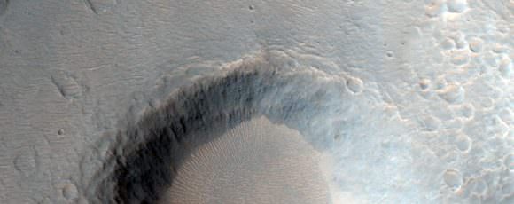
HiPOD from February 16th 2020 showing dust devil trails in a Martian crater. Image Credit: NASA/JPL/UArizona
There may be no life on Mars, but there’s still a lot going on there. The Martian surface is home to different geological process, which overlap and even compete with each other to shape the planet. Orbiters with powerful cameras give us an excellent view of Mars’ changing surface.
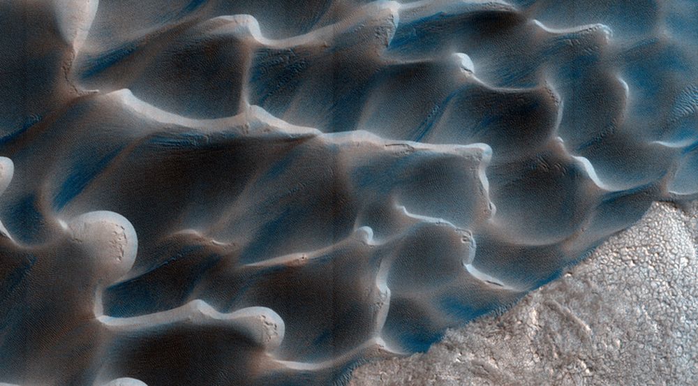
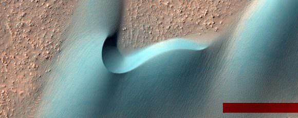
Mars is a sandy planet and the HiRISE camera on the Mars Reconnaissance Orbiter (MRO) has given us tons of beautiful pictures of Martian sand dunes. But Mars’ dunes are much different than dunes here on Earth. Their movement is governed by different factors than Earth dunes.
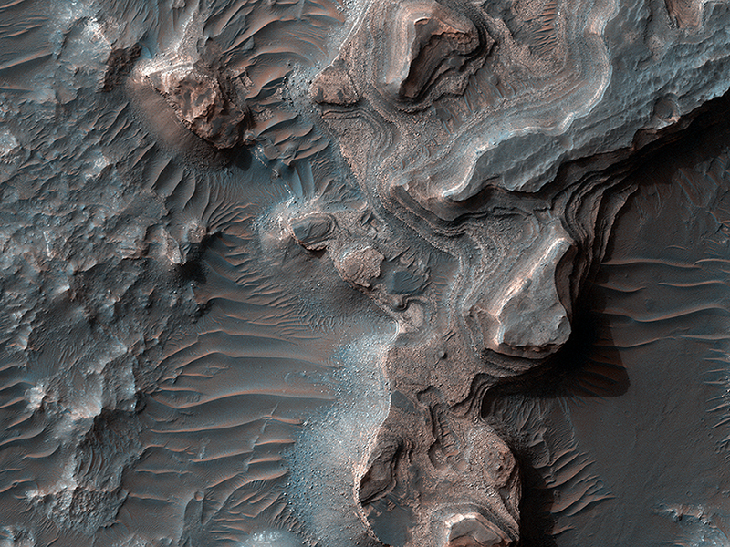
Layered deposits in Uzboi Vallis on Mars, as seen by the HiRISE camera on the Mars Reconnaissance Orbiter. Credit: NASA/JPL/University of Arizona.
We’ve posted several ‘flyover’ videos of Mars that use data from spacecraft. But this video might be the most spectacular and realistic. Created by filmmaker Jan Fröjdman from Finland, “A Fictive Flight Above Real Mars” uses actual data from the venerable HiRISE camera on board the Mars Reconnaissance Orbiter, and takes you on a 3-D tour over steep cliffs, high buttes, amazing craters, polygons and other remarkable land forms. But Fröjdman also adds a few features reminiscent of the landing videos taken by the Apollo astronauts. Complete with crosshatches and thruster firings, this video puts you on final approach to land on (and then take off from) Mars’ surface.
(Hit ‘fullscreen’ for the best viewing)
To create the video, Fröjdman used 3-D anaglyph images from HiRISE (High Resolution Science Imaging Experiment), which contain information about the topography of Mars surface and then processed the images into panning video clips.
Fröjdman told Universe Today he worked on this video for about three months.
“The most time consuming was to manually pick the more than 33,000 reference points in the anaglyph images,” he said via email. “Now when I count how many steps there were in total in the process, I come to seven and I needed at least 6 different kinds of software.”
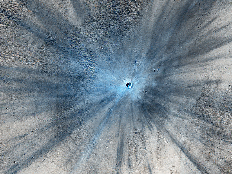
A new impact crater that was formed between July 2010 and May 2012, as seen by the HiRISE camera on the Mars Reconnaissance Orbiter. This image is part of “A Fictive Flight Above Real Mars” by Jan Fröjdman. Credit: NASA/JPL/University of Arizona.
Fröjdman, a landscape photographer and audiovisual expert, said he wanted to create a video that gives you the feeling “that you are flying above Mars looking down watching interesting locations on the planet,” he wrote on Vimeo. “And there are really great places on Mars! I would love to see images taken by a landscape photographer on Mars, especially from the polar regions. But I’m afraid I won’t see that kind of images during my lifetime.”
Between HiRISE and the Curiosity rover images, we have the next best thing to a human on Mars. But maybe one day…
Using its HiRISE camera, the MRO has noted existence of tall networks of ridges on Mars that have diverse origins. Credit: NASA/JPL-Caltech/Univ. of Arizona
Mars has some impressive geological features across its cold, desiccated surface, many of which are similar to featured found here on Earth. By studying them, scientists are able to learn more about the natural history of the Red Planet, what kinds of meteorological phenomena are responsible for shaping it, and how similar our two planets are. A perfect of example of this are the polygon-ridge networks that have been observed on its surface.
One such network was recently discovered by the Mars Reconnaissance Orbiter (MRO) in the Medusae Fossae region, which straddles the planet’s equator. Measuring some 16 story’s high, this ridge network is similar to others that have been spotted on Mars. But according to a survey produced by researchers from NASA’s Jet Propulsion Laboratory, these ridges likely have different origins.
This survey, which was recently published in the journal Icarus, examined both the network found in the Medusae Fossae region and similar-looking networks in other regions of the Red Planet. These ridges (sometimes called boxwork rides), are essentially blade-like walls that look like multiple adjoining polygons (i.e. rectangles, pentagons, triangles, and similar shapes).
Shiprock, a ridge-feature in northwestern New Mexico that is 10 meters (30 feet) tall, which formed from lava filling an underground fracture that resisted erosion better than the material around it did. Credit: NASA
While similar-looking ridges can be found in many places on Mars, they do not appear to be formed by any single process. As Laura Kerber, of NASA’s Jet Propulsion Laboratory and the lead author of the survey report, explained in a NASA press release:
“Finding these ridges in the Medusae Fossae region set me on a quest to find all the types of polygonal ridges on Mars… Polygonal ridges can be formed in several different ways, and some of them are really key to understanding the history of early Mars. Many of these ridges are mineral veins, and mineral veins tell us that water was circulating underground.”
Such ridges have also been found on Earth, and appear to be the result of various processes as well. One of the most common involves lava flowing into preexisting fractures in the ground, which then survived when erosion stripped the surrounding material away. A good example of this is the Shiprock (shown above), a monadrock located in San Juan County, New Mexico.
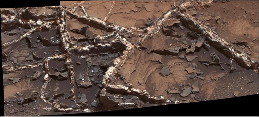
Examples of polygon ridges on Mars include the feature known as “Garden City“, which was discovered by the Curiosity rover mission. Measuring just a few centimeters in height, these ridges appeared to be the result of mineral-laden groundwater moving through underground fissures, which led to standing mineral veins once the surrounding soil eroded away.
Mineral veins at the “Garden City” site, examined by NASA’s Curiosity Mars rover. Credit: NASA/JPL
At the other end of the scale, ridges that measure around 2 kilometers (over a mile) high have also been found. A good example of this is “Inca City“, a feature observed by the Mars Global Surveyor near Mars’ south pole. In this case, the feature is believed to be the result of underground faults (which were formed from impacts) filling with lava over time. Here too, erosion gradually stripped away the surrounding rock, exposing the standing lava rock.
In short, these features are evidence of underground water and volcanic activity on Mars. And by finding more examples of these polygon-ridges, scientists will be able to study the geological record of Mars more closely. Hence why Kerber is seeking help from the public through a citizen-science project called Planet Four: Ridges.
Established earlier this month on Zooniverse – a volunteer-powered research platform – this project has made images obtained by the MRO’s Context Camera (CTX) available to the public. Currently, this and other projects using data from CTX and HiRISE have drawn the participation of more than 150,000 volunteers from around the world.
By getting volunteers to sort through the CTX images for ridge formations, Kerber and her team hopes that previously-unidentified ones will be identified and that their relationship with other Martian features will be better understood.
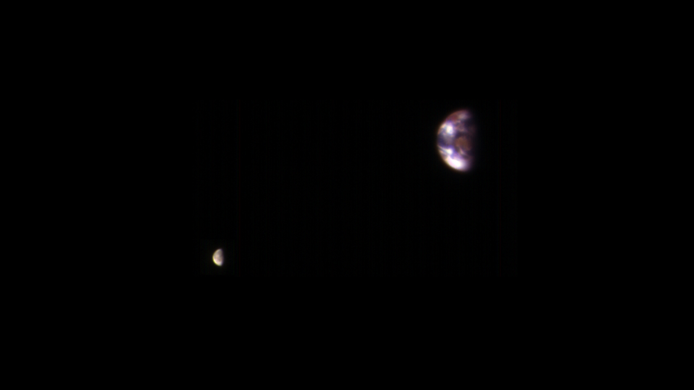
A view of Earth and its Moon, as seen from Mars. It combines two images acquired on Nov. 20, 2016, by the HiRISE camera on NASA's Mars Reconnaissance Orbiter, with brightness adjusted separately for Earth and the moon to show details on both bodies. Credit: NASA/JPL-Caltech/Univ. of Arizona.
The incredible HiRISE camera on board the Mars Reconnaissance Orbiter turned its eyes away from its usual target – Mars’ surface – and for calibration purposes only, took some amazing images of Earth and our Moon. Combined to create one image, this is a marvelous view of our home from about 127 million miles (205 million kilometers) away.
Alfred McEwen, principal investigator for HiRISE said the image is constructed from the best photo of Earth and the best photo of the Moon from four sets of images. Interestingly, this combined view retains the correct positions and sizes of the two bodies relative to each other. However, Earth and the Moon appear closer than they actually are in this image because the observation was planned for a time at which the Moon was almost directly behind Earth, from Mars’ point of view, to see the Earth-facing side of the Moon.
A view of Earth and its Moon, as seen from Mars. It combines two images acquired on Nov. 20, 2016, by the HiRISE camera on NASA’s Mars Reconnaissance Orbiter, with brightness adjusted separately for Earth and the moon to show details on both bodies. Credit: NASA/JPL-Caltech/Univ. of Arizona.
“Each is separately processed prior to combining (in correct relative positions and sizes), so that the Moon is bright enough to see,” McEwen wrote on the HiRISE website. “The Moon is much darker than Earth and would barely show up at all if shown at the same brightness scale as Earth. Because of this brightness difference, the Earth images are saturated in the best Moon images, and the Moon is very faint in the best (unsaturated) Earth image.”
Earth looks reddish because the HiRISE imaging team used color filters similar to the Landsat images where vegetation appears red.
“The image color bandpasses are infrared, red, and blue-green, displayed as red, green, and blue, respectively,” McEwen explained. “The reddish blob in the middle of the Earth image is Australia, with southeast Asia forming the reddish area (vegetation) near the top; Antarctica is the bright blob at bottom-left. Other bright areas are clouds. We see the western near-side of the Moon.”
HiRISE took these pictures on Nov. 20, 2016, and this is not the first time HiRISE has turned its eyes towards Earth.
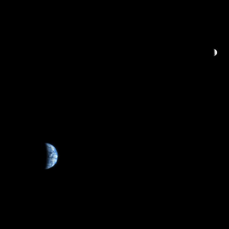
Back in 2007, HiRISE took this image, below, from Mars’ orbit when it was just 88 million miles (142 million km) from Earth. This one is more like how future astronauts might see Earth and the Moon through a telescope from Mars’ orbit.
An image of Earth and the Moon, acquired on October 3, 2007, by the HiRISE camera on NASA’s Mars Reconnaissance Orbiter. Credit: NASA/JPL-Caltech/University of Arizona.
If you look closely, you can make out a few features on our planet. The west coast outline of South America is at lower right on Earth, although the clouds are the dominant features. In fact, the clouds were so bright, compared with the Moon, that they almost completely saturated the filters on the HiRISE camera. The people working on HiRISE say this image required a fair amount of processing to make such a nice-looking picture.
You can see an image from a previous Mars’ orbiter, the Mars Global Surveyor, that took a picture of Earth, the Moon and Jupiter — all in one shot — back in 2003 here.
Artist's impression of geysers at the Martian south polar icecap as southern spring begins. Credit: NASA/JPL-Caltech/Arizona State University/Ron Miller
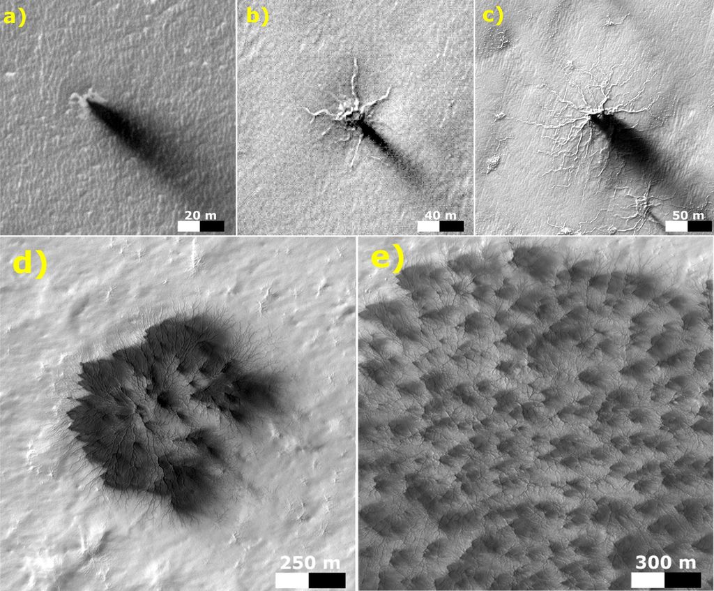
For years, scientists have understood that in Mars’ polar regions, frozen carbon dioxide (aka. dry ice) covers much of the surface during the winter. During the spring, this ice sublimates in places, causing the ice to crack and jets of CO² to spew forth. This leads to the formation of dark fans and features known as “spiders”, both of which are unique to Mars’ southern polar region.
For the past decade, researchers have failed to see these features changing from year-to-year, where repeated thaws have led to their growth. However, using data from the Mars Reconnaissance Orbiter‘s (MRO) HiRISE camera, a research team from the University of Colorado, Boulder and the Planetary Science Institute in Arizona have managed to catch sight of the cumulative growth of a spider for the first time from one spring to the next.
Spiders are so-named because of their appearance, where multiple channels converge on a central pit. Dark fans, on the other hand, are low-albedo patches that are darker than the surrounding ice sheet. For some time, astronomers have been observed these features in the southern polar region of Mars, and multiple theories were advanced as to their origin.
HiRISE images of the Martian landscape, showing outgassing and the formation of dark fans and “spiders”. Credit: NASA/JPL
In 2007, Hugh Kieffer of the Space Science Institute in Boulder, Colorado theorized that the dark fans and spiders were linked, and that both features were the result of spring thaws. In short, during Mars’ spring season – when the southern polar region is exposed to more sunlight – the Sun’s rays penetrates the ice sheets and warm the ground underneath.
This causes gas flows to form beneath the ice that build up pressure, eventually causing the ice to crack and triggering geysers. These geysers deposit mineral dust and sand across the surface downwind from the eruption, while the cracks in the ice grow and become visible from orbit. While this explanation has been widely-accepted, scientists have been unable to observe this process in action.
By using data from the MRO’s High Resolution Imaging Science Experiment (HiRISE), the research team was able to spot a small-channeled troughs in the southern region which persisted and grew over a three year period. In addition to closely resembling spidery terrain, it was in proximity to dark fan sites. From this, they determined that they were witnessing a spider that was in the process of formation.
As Dr. Ganna Portyankina – a researcher from the Laboratory for Atmospheric and Space Physics at the University of Colorado, Boulder, and the lead author on the team’s research paper – explained to Universe Today via email,
“We have observed different changes in the surface caused by CO² jets before. However, they all were either seasonal changes in surface albedo, like dark fans, or they were only short-lived and were gone the next year, like furrows. This time, the troughs have stayed over several years and they develop dendritic-type of extension – right the way we expect the large spiders to develop.”
Spiders trace a delicate pattern on top of the residual polar cap, after the seasonal carbon-dioxide ice slab has disappeared. Next spring, these will likely mark the sites of vents when the CO2 icecap returns. This MOC image is about 2 miles wide. Credit: NASA/JPL/MSSS
Furrows that were similar to the spidery terrain have been spotted at Mars’ north pole in the past, which coincided with a Martian spring. On these occasions, scientists using data from HiRISE instrument reported seeing small furrows on sand dunes, where eruptions had deposited dark fans. However, in what is typical of northern furrows, these were non-persisting annual occurrences, disappearing when summer winds deposited sand in them.
In contrast, the troughs Dr. Portyankina and her team observed in the southern polar region were persistent over a three-year period. During this time, these features extended and developed new “tributaries”, forming a dendritic pattern that resembled a Martian spider. From this, they concluded that the previously-observed northern furrows have the same cause – i.e. sublimation causing outgassing.
However, they also concluded that the northern furrows do not develop over time because of the high-mobility of dune material in the northern polar region. The difference, it seems, comes down to the presence of erosive sand material in the north and south, which creates (or starts) the erosive process that leads to the formation of spider-like troughs – which both kick-stars the process but can also erase it.
“Many locations in the south polar regions with seasonal dark fans show no visible sand deposits,” said Dr. Portyankina. “Dark fans in those locations might be only a mix of regolith and dust, or even just dust on its own – as it is really everywhere on Mars… [T]hose locations that have sand will experience higher erosion simply because there is granular material in the gas flow. Basically, it is old simple sandblasting. This means, it must be easier and faster to carve spiders in those locations.”
Images of dark spots (left) and fans (right) observed on top of the Martian south polar cap taken in southern spring. Credit: NASA/JPL/MSSS
In other words, where sand exists beneath the ice sheet, the ground beneath that is likely to be rockier (i.e. harder)> The formation of spider terrain may thereofre require that the ground beneath the ice be soft enough to be carved, but not so loose that it will refill the channels during a single seasonal cycle. In short, the formation of spidery terrain appears to be dependent upon the difference in surface composition between the poles.
In addition, from the many year’s of HiRISE data that has been accumulated, Dr. Portyankina and her team were also able to gauge the current rate of erosion in Mars’ southern polar region. Ultimately, they estimated that smaller spider-like furrows would require a thousand Martian years (about 1,900 Earth years) in order to become a full-scale spider.
This study is certainly significant, since understanding how seasonal changes and present-day erosion lead to the creation of new topographical features is important when it comes to understanding the processes that shape Mars’ polar regions. As we get closer and closer to the day when crewed missions and even settlement become a reality, knowing how these processes shape the planet will be fundamental to making a go of things on Mars.
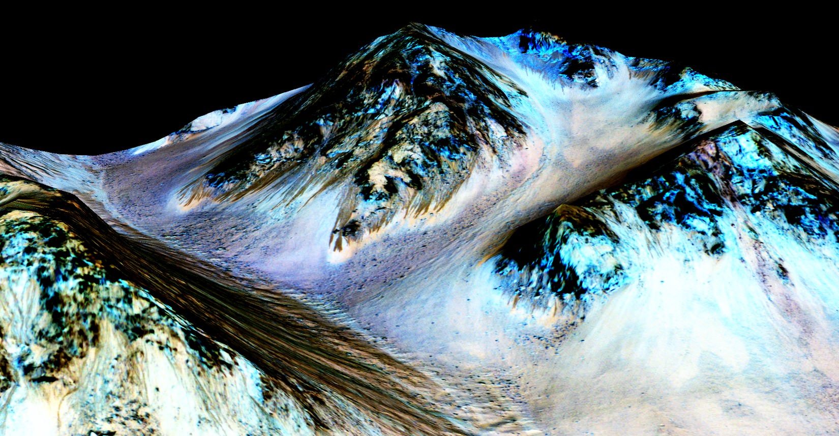
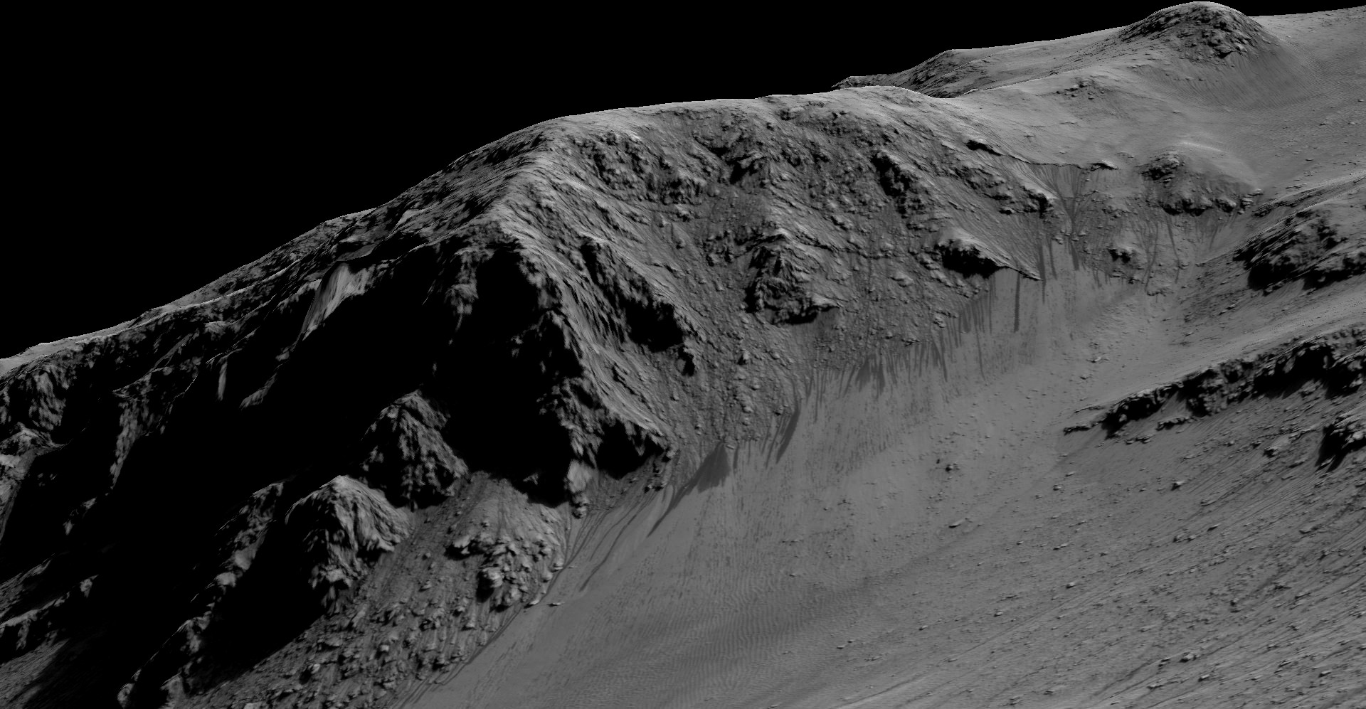
A possible 'Recurring Slope Lineae (RSL), dark streaks on slopes that appeared to ebb and flow over time that may or may not be caused by water on Mars. This RSL is in Ceraunius Fossae. Credit: NASA/JPL/University of Arizona.
We frequently call the HiRISE camera on board the Mars Reconnaissance Orbiter “our favorite camera” and for good reason. HiRISE, the High Resolution Imaging Science Experiment, is the largest and most powerful camera ever flown on a planetary mission, sending back incredibly beautiful, high-resolution images of Mars. While previous cameras on other Mars orbiters can identify objects about the size of a school bus, HiRISE brings it to human scale, imaging objects as small as 3 feet (1 meter) across.
The HiRISE team has just released more than 1,000 new observations of Mars for the Planetary Data System archive, showing a wide range of gullies, dunes, craters, geological layering and other features on the Red Planet. Take a look at some of the highlights (click on each image for higher resolution versions and more info):
Chloride and Paleo Dunes in Terra Sirenum. Credit: NASA/JPL/University of Arizona.
MRO orbits at about 300 km above the Martian surface. The width of a HiRISE image covers about about 6 km, with a 1.2 km strip of color in the center. The length of the images can be up to 37 km. If you click on each of these images here, or go to the HiRISE website, you can see the full images in all their glory. To fully appreciate the images, you can download the special HiView application, which allows you to see the images in various formats.
Dunes Within Arkhangelsky Crater. Credit: NASA/JPL/University of Arizona
HiRISE has been nicknamed “The People’s Camera“ because the team allows the public to choose specific targets for the camera to image. Check out the HiWISH page here if you’d like a certain spot on Mars imaged.
Crater Near Hydaspis Chaos. Credit: NASA/JPL/University of Arizona.
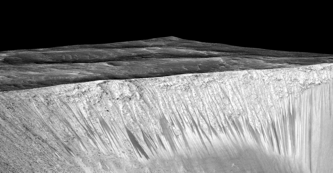
The lead image (the link to the image on the HiRISE site is here) shows a possible recurring slope lineae (RSL), mysterious dark streaks on slopes that appeared to ebb and flow over time. They darken and appear to flow down steep slopes during warm seasons, and then fade in cooler seasons. One possibility is this is evidence of liquid water present on Mars today. Some scientists said it could be a salty, briny liquid water flowing down the slopes. But a recent analysis says the RSLs show no mineralogical evidence for abundant liquid water or its by-products, and so it might be mechanisms other than the flow of water — such as the freeze and thaw of carbon dioxide frost — as being the major drivers of recent RSLs.
These dark, narrow, 100 meter-long streaks called recurring slope lineae flowing downhill on Mars are inferred to have been formed by contemporary flowing water. However, a new study by planetary scientists indicates that these may actually be the result of dry flows. Credits: NASA/JPL/University of Arizona
These dark, narrow, 100 meter-long streaks called recurring slope lineae flowing downhill on Mars are inferred to have been formed by contemporary flowing water. Recently, planetary scientists detected hydrated salts on these slopes at Hale crater, corroborating their original hypothesis that the streaks are indeed formed by liquid water. The blue color seen upslope of the dark streaks are thought not to be related to their formation, but instead are from the presence of the mineral pyroxene.
The image is produced by draping an orthorectified Infrared-Red-Blue/Green(IRB)) false color image on a Digital Terrain Model (DTM). This model was produced by researchers at the University of Arizona, much like the High Resolution Imaging Science Experiment (University of Arizona). The vertical exaggeration is 1.5.
NASA and Mars planetary scientists announced today (Sept. 28) that salty “liquid water flows intermittently” across multiple spots on the surface of today’s Mars – trumpeting a major scientific discovery with far reaching implications regarding the search for life beyond Earth and bolstering the chances for the possible existence of present day Martian microbes.
Utilizing spectroscopic measurements and imaging gathered by NASA’s Mars Reconnaissance Orbiter (MRO), researchers found the first strong evidence confirming that briny water flows on the Red Planet today along dark streaks moving downhill on crater slopes and mountain sides, during warmer seasons.
“Mars is not the dry, arid planet that we thought of in the past. Today we announce that under certain circumstances, liquid water has been found on Mars,” said Jim Green, NASA Planetary Science Director at NASA Headquarters, at a media briefing held today, Sept 28.
“When you look at Earth, water is an essential ingredient. Everywhere we go where there’s liquid water, whether its deep in the Earth or in the arid regions, we find life. This is tremendously exciting.”
“We haven’t been able to answer the question – does life exist beyond Earth? But following the water is a critical element of that. We now have great opportunities to be in the right locations on Mars to thoroughly investigate that,” Green elaborated.
“Water! Strong evidence that liquid water flows on present-day Mars,” NASA officials tweeted about the discovery.
The evidence comes in the form of the detection of mysterious dark streaks, as long as 100 meters, showing signatures of hydrated salt minerals periodically flowing in liquid water down steep slopes on the Red Planet that “appear to ebb and flow over time.”
The source of the water is likely from the shallow subsurface or possibly absorbed from the atmosphere.
Dark narrow streaks called recurring slope lineae emanating out of the walls of Garni crater on Mars. The dark streaks here are up to few hundred meters in length. They are hypothesized to be formed by flow of briny liquid water on Mars. The image is produced by draping an orthorectified (RED) image (ESP_031059_1685) on a Digital Terrain Model (DTM) of the same site produced by High Resolution Imaging Science Experiment (University of Arizona). Vertical exaggeration is 1.5. Credits: NASA/JPL/University of Arizona
Water is a key prerequisite for the formation and evolution of life as we know it. So the new finding significantly bolsters the chances that present day extant life could exist on the Red Planet.
“Our quest on Mars has been to ‘follow the water,’ in our search for life in the universe, and now we have convincing science that validates what we’ve long suspected,” said John Grunsfeld, astronaut and associate administrator of NASA’s Science Mission Directorate in Washington.
“This is a significant development, as it appears to confirm that water — albeit briny — is flowing today on the surface of Mars.”
“This increases the chance that life could exist on Mars today,” noted Grunsfeld.
The data were gathered by and the conclusions are based on using two scientific instruments – the high resolution imaging spectrometer on MRO known as High Resolution Imaging Science Experiment (HiRISE), as well as MRO’s mineral mapping Compact Reconnaissance Imaging Spectrometer for Mars (CRISM).
The mysterious dark streaks of downhill flows are known as recurring slope lineae (RSL).
They were first detected in 2010 at dozens of sites on the sun facing slopes of deep craters by Lujendra Ojha, then a University of Arizona undergraduate student.
The new finding is highly significant because until today’s announcement, there was no strong evidence that liquid water could actually exist on the Martian surface because the atmospheric pressure was thought to be far too low – its less than one percent of Earth’s.
The flow of water is occasional and not permanent, seasonally variable and dependent on having just the right mix of atmospheric, temperature and surface conditions with salt deposits on Mars.
Portions of Mars were covered with an ocean of water billions of years ago when the planet was far warmer and more hospitable to life. But it underwent a dramatic climate change some 3 billion years ago and lost most of that water.
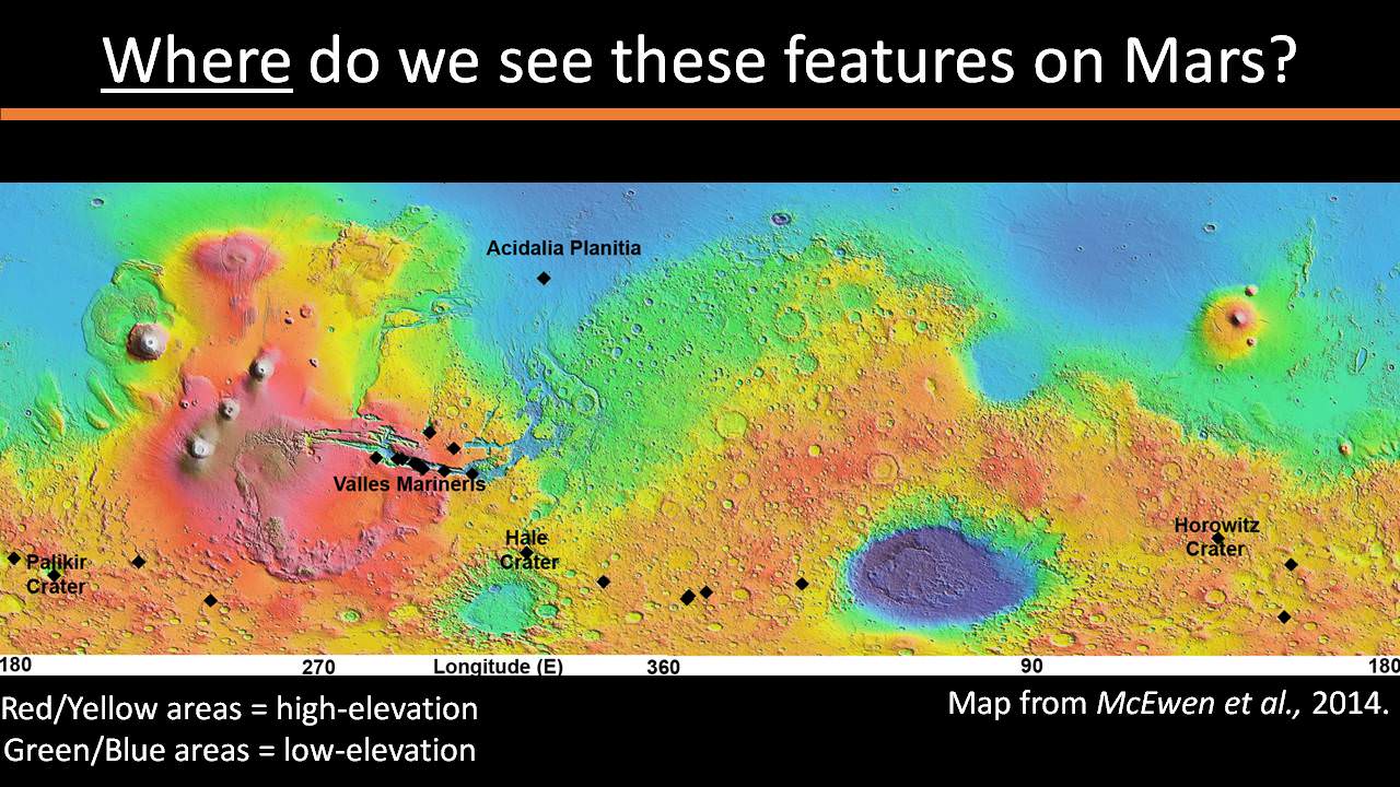
The RSL with flowing water appear in at least three different locations on Mars – including Hale crater, Horowitz crater and Palikir crater – when temperatures are above minus 10 degrees Fahrenheit (minus 23 Celsius). They appear during warm seasons, fade in cooler seasons and disappear during colder times.
Pure surface water ice would simply sublimate and evaporate away as the temperature rises. Mixing in surface salts lowers the melting point of ice, thereby allowing the water to potentially liquefy on Mars surface for a certain period of time rather than sublimating rapidly away.
“These are dark streaks that form in late spring, grow through the summer and then disappear in the fall,” said Michael Meyer lead scientist for the Mars Exploration Program at NASA Headquarters, at the media briefing.
Years of painstaking effort and laboratory work was required to verify and corroborate the finding of flowing liquid water.
“It took multiple spacecraft over several years to solve this mystery, and now we know there is liquid water on the surface of this cold, desert planet,” said Meyer. “It seems that the more we study Mars, the more we learn how life could be supported and where there are resources to support life in the future.”
The dark, narrow streaks flowing downhill on Mars at sites such as this portion of Horowitz Crater are inferred to be formed by seasonal flow of water on modern-day Mars. The streaks are roughly the length of a football field. These dark features on the slopes are called “recurring slope lineae” or RSL. The imaging and topographical information in this processed view come from the High Resolution Imaging Science Experiment (HiRISE) camera on NASA’s Mars Reconnaissance Orbiter. Credit: NASA/JPL-Caltech/Univ. of Arizona
Along with the media announcement, the researchers published their findings today in a refereed scientific paper in the Sept. 28 issue of Nature Geoscience.
“We found the hydrated salts only when the seasonal features were widest, which suggests that either the dark streaks themselves or a process that forms them is the source of the hydration. In either case, the detection of hydrated salts on these slopes means that water plays a vital role in the formation of these streaks,” said Lujendra Ojha, now at the Georgia Institute of Technology (Georgia Tech) in Atlanta, and lead author of the Sept. 28 publication in Nature Geoscience.
The scientists “interpret the spectral signatures as caused by hydrated minerals called perchlorates.”
Ojha said the chemical signatures from CRISM were most consistent with the detection of mixtures of magnesium perchlorate, magnesium chlorate and sodium perchlorate, based on lab experiments.
“Some perchlorates have been shown to keep liquids from freezing even when conditions are as cold as minus 94 degrees Fahrenheit (minus 70 Celsius).”
Perchlorates have previously been detected in Martian soil by two of NASA’s surface missions – the Phoenix lander and the Curiosity rover. There is also some evidence that NASA’s Viking missions in the 1970s measured signatures of these salts.
On Earth concentration of perchlorates are found in deserts.
This also marks the first time perchlorates have been identified from Mars orbit.
So NASA astronaut Mark Kelly exclaimed that he was also super excited about the findings, from his perch serving as Commander aboard the International Space Station (ISS), where he is a member of the first ever “1 Year ISS Mission Crew” aimed at learning how the human body will adapt to the long term missions required to send astronauts to Mars and back.
“One reason why NASA’s discovery of liquid water on #Mars is so exciting: we know anywhere there’s water on Earth, there’s some form of life,” Kelly tweeted today from on board the ISS, upon hearing today’s news.
The discovery of liquid water on Mars could also be a boon to future astronauts who could use it as a natural resource to ‘live off the land’ for sustenance and to make rocket fuel.
“If going to Mars on my Year In Space, I’d arrive soon to find water! H20 > rocket fuel, which means I could find my way back home too!,” Kelly wrote on his Facebook page.
“When most people talk about water on Mars, they’re usually talking about ancient water or frozen water,” Ojha explained.
“Now we know there’s more to the story. This is the first spectral detection that unambiguously supports our liquid water-formation hypotheses for RSL.”
Stay tuned here for Ken’s continuing Earth and planetary science and human spaceflight news.
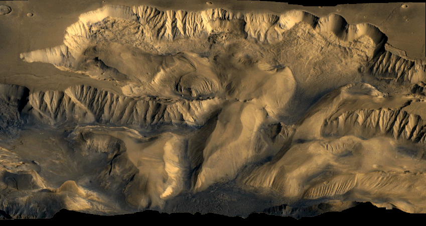
A color mosaic of Candor Chasma (part of Mars' Valles Marineris) based on data from Voyager 1 and Voyager 2. Credit: NASA
Mars today is a planet that appears to be mostly shaped by wind, but that wasn’t always the case. A new map adds information to the hypothesis that “marsquakes” affected at least a part of the planet’s vast canyon, Valles Marineris, while the area contained spring-filled lakes.
When the damp sand got shaken up, it deposited itself in hills. NASA says the new map, based on observations from the Mars Reconnaissance Orbiter (which you can see below), adds credence to the theory that it was water that made these deposits.
“The conditions under which sedimentary deposits in it formed have been an open issue for decades,” NASA wrote in a press release. “Possibilities proposed have included accumulation in lakebeds, volcanic eruptions under glaciers within the canyons, and accumulation of wind-blown sand and dust.”
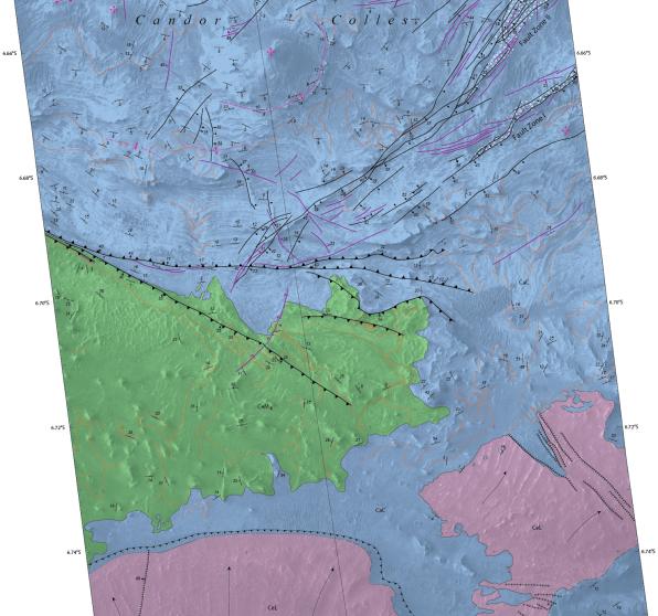
The map you see below was created by the U.S. Geological Survey, which has more extensive information on the findings at this website. The observations also produced a suite of research in recent years, such as this 2009 paper led by Scott Murchie at the Johns Hopkins University Applied Research Laboratory.
Part of a map of Candor Chasma (part of Mars’ Valles Marineris) based on observations from the Mars Reconnaissance Orbiter. Green is knobby terrain, pink is lobate deposits (ridged material) and blue “stair-stepped morphology” of hills and mesas. Credit: U.S. Geological Survey
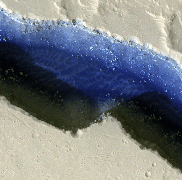
A false-color image of part of Cerberus Fossae on Mars. The view shows two rifts intersecting with each other, with sand (in deep blue) and dust. Credit: NASA/JPL-Caltech/University of Arizona/Western University Planetary Sciences Division
Here’s the awesome thing about space and social media: in some cases, you can often follow along with a mission almost as soon as the images come to Earth. A group of Canadians is taking that to the next level this month as they take control of the 211th imaging cycle of a powerful camera on the Mars Reconnaissance Orbiter.
While some images need to be kept back for science investigations, the team is sharing several pictures a day on Twitter and on Facebook portraying the views they saw coming back from the High Resolution Imaging Science Experiment (HiRISE) camera. The results are astounding, as you can see in the images below.
“It’s mind-blowing to realize that when the team, myself included, first look at the images, we are likely the first people on Earth to lay eyes upon a portion of the Martian surface that may have not been imaged before at such high resolution,” stated research lead Livio Tornabene, who is part of Western University’s center for planetary science and exploration.
The team will capture up to 150 images between Nov. 30 and Dec. 12, and already have released close to two dozen to the public. Some of the best are below.
.@HiRISE image ESP_039152_1450 Tongue-shaped feature on south mid-latitude crater; Mars sticking its tongue out at us pic.twitter.com/F5LeG5e03m
— Western Mars Imaging (@westernuMars) December 5, 2014
— Western Mars Imaging (@westernuMars) December 5, 2014
Beautiful two-toned ejecta impact crater on Mars! Another lovely image brought to you by @HiRISE#WesternU 🙂 pic.twitter.com/q0FY2r6q8Y — Western Mars Imaging (@westernuMars) December 8, 2014
— Western Mars Imaging (@westernuMars) December 5, 2014
.@HiRISE image ESP_039149_1475 Gully monitoring in crater; looking for various changes over time. #WesternU#LdnOntpic.twitter.com/0DiXo7xrbd — Western Mars Imaging (@westernuMars) December 5, 2014