Phoenix Lander Still Visible in New HiRISE Images from Mars

The Phoenix lander still visible at Mars north polar region, nearly 4 Earth years and 2 Mars years after the spacecraft landed on Mars. Credit: NASA/JPL/University of Arizona

[/caption]

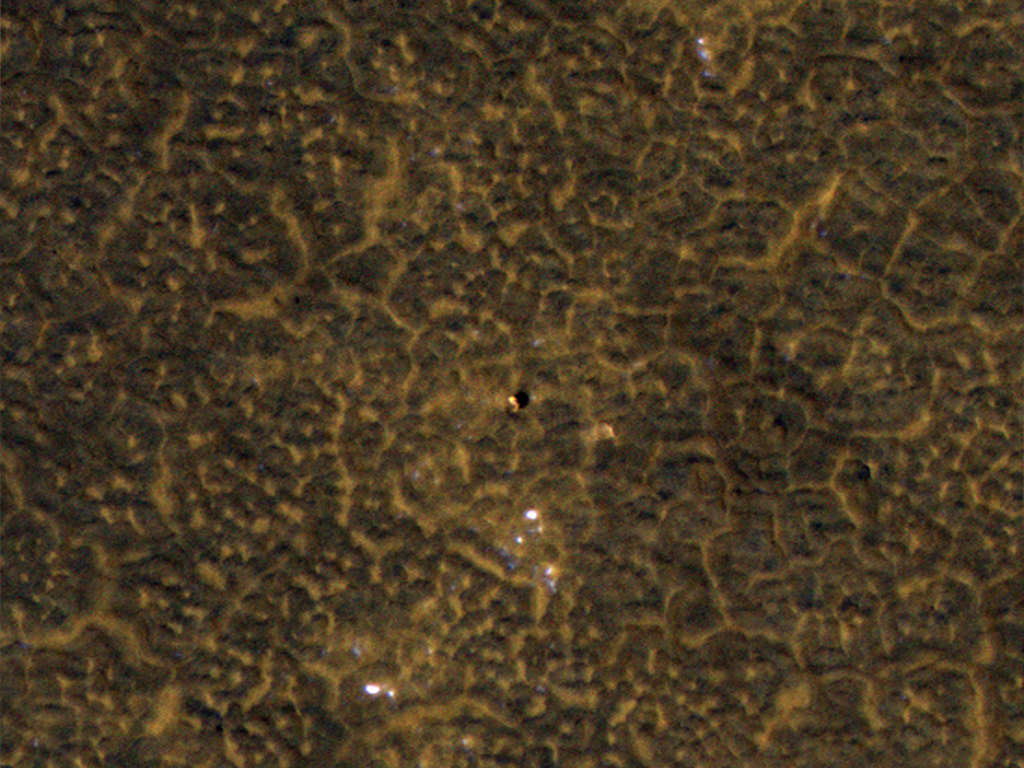
I spy Phoenix! said the HiRISE camera on board the Mars Reconnaissance Orbiter! This new image acquired on January 26, 2012 shows that the Phoenix lander and its backshell are still visible from Mars’ orbit. The parachute, seen in earlier images, is probably about 130 meters south of where this picture ends. This is one of a series of images to monitor frost patterns at the Phoenix landing site, said HiRISE Principal Investigator, Alfred McEwen, adding that this new images shows almost the same appearance of the hardware as 1 Mars years ago, in 2010. See larger versions of this image at the HiRISE website.

See below for comparison images from orbit from 2008, shortly after Phoenix landed and 2010, after the mission had ended.

Two images of the Phoenix Mars lander taken from Martian orbit in 2008 and 2010. The 2008 lander image shows two relatively blue spots on either side corresponding to the spacecraft's clean circular solar panels. In the 2010 image scientists see a dark shadow that could be the lander body and eastern solar panel, but no shadow from the western solar panel. Image credit: NASA/JPL-Caltech/University of Arizona

In these images, also from the Mars Reconnaissance Orbiter, signs of severe ice damage to the lander’s solar panels show up in the 2010 image, with one panel appearing to be completely gone. The Phoenix team says this is consistent with predictions of how Phoenix could be damaged by harsh winter conditions. It was anticipated that the weight of a carbon-dioxide ice buildup could bend or break the solar panels.

Source: HiRISE

New Avalanche in Action on Mars Captured by HiRISE

An avalanche on Mars captured by the HiRISE camera on the Mars Reconnaissance Orbiter on November 27, 2011. Credit: NASA/JPL/University of Arizona.

[/caption]

Its avalanche season on Mars! And once again the HiRISE camera on the Mars Reconnaissance Orbiter has captured an avalanche taking place on a steep cliff or scarp in Mars’ north polar region. Back in 2008, the HiRISE team created quite a sensation when it captured an avalanche in action on Mars. The high resolution camera did it again in 2010 when springtime arrived once more. Now, another Mars year later, the team has been monitoring specific areas, looking for evidence of avalanches and they hit pay dirt – literally. This image of an avalanche taking place is from a large image “strip” from HiRISE taken in the extreme northern latitude of Mars, about 85 degrees north.

Dust, fine-grained ice and possibly large blocks of either regolith or rocks has detached from a steep, towering cliff and cascaded below. The HiRISE team say the occurrence of avalanches is spectacularly revealed by the accompanying clouds of fine material that continue to settle out of the air.

The avalanches are a result of carbon-dioxide frost that clings to the scarp in the darkness of winter, and when sunlight hits them in the spring they loosen up and fall.

These events happen mostly in the middle of spring, roughly equivalent to April to early May on Earth. And it seems this is a regular spring process at Mars’ north pole that may be expected every year.

This image is part of the latest PDS release from HiRISE.

Hat tip: Jason Major and Discovery Space

Incredible 3-D View Inside a Martian Crater

A 3-d view of a well-preserved and unnamed impact crater on Mars, as seen by the HiRISE camera on the Mars Reconnaisancee Orbiter. Credit: NASA/JPL/University of Arizona. Click for high-resolution version.

[/caption]

This is why I always keep a pair of 3-D glasses by my computer. This well-preserved crater on Mars may look like just your average, run-of-the-mill impact crater in 2-D, but in 3-D, the sharply raised rim, the deep, cavernous crater body, and especially the steep crater walls will have you grabbing your armchairs so you don’t fall in. The image is courtesy of the HiRISE camera team from the Mars Reconnaissance Orbiter. This unnamed crater is about 6 or 7 kilometers wide from rim to rim. HiRISE took the image on New Year’s Eve 2011.

HiRISE principal investigator Alfred McEwen says that the camera has imaged hundreds of well-preserved impact craters on Mars ranging from 1 meter to more than 100 kilometers wide. What can the scientists learn from craters?

“These targets are of great interest for multiple reasons,” he said. “First, we want to better understand impact cratering, a fundamental surface process. Second, such craters often contain good exposures of bedrock in the steep walls and, if the crater is large enough, in the central uplift. Just like terrestrial geologists are attracted to good bedrock outcrops like road cuts, planetary geologists are attracted to well-preserved craters.

“Third, the steep slopes often reveal active processes, such as formation of gullies, boulder falls, and slope streaks that could form in a variety of ways. Some of these active processes could be related to water, since the crater may expose lenses of ice or salty water, or create deep shadows that trap volatiles, or expose salts that can extract water from the air.”

Plus, they are just plain wonderful to behold, especially in the resolution the HiRISE can obtain.

A non-3-D version of the same image. Credit: NASA/JPL/University of Arizona

Source: HiRISE

Scientists Still Searching for the Beagle 2 Crash Site on Mars

An image from the HiRISE camera of the Isidis basin region where the Beagle 2 lander was supposed to touch down. Credit: NASA/JPL/University of Arizona

[/caption]

Since its disappearance in December 2003, scientists and citizen scientists alike have continued the search for Europe’s Beagle 2 lander which likely crashed on Mars. Its disappearance is a mystery and if the spacecraft could be located, it might be possible to discover what went wrong.

The Mars Reconnaissance Orbiter’s powerful HiRISE camera has been regularly taking high-resolution images of the Isidis basin region where the Beagle 2 lander was supposed to touch down.

“Nothing resembling the Beagle lander has been seen in any of the HiRISE images, although we aren’t sure that they’ve been thoroughly searched,” said HiRISE Principal Investigator Alfred McEwen, writing on the HiRISE website.

So, join in the search and take a look!

Above is the 12th such image taken by HiRISE.

McEwen said the easiest thing to spot would be the bright parachute — if it actually deployed. Remember how HiRISE was able to find the parachutes at the MER landing sites, and even capture the Phoenix lander descending on its parachute? The Beagle 2’s parachute would be a good clue to search for.

(As we reported earlier, the HiRISE team will attempt to image the Mars Science Laboratory during its descent to Mars’ surface in August, as it did for Phoenix.)

Dust should not be a problem as far as hiding the lander or parachutes, McEwen said. “Dust deposition over the past eight years probably would not disguise the bright feature over equatorial regions of Mars,” he said noting that the parachutes are still easy to spot at the MER and Pathfinder landing sites. “At high latitudes the brightness patterns are reset each winter by the seasonal deposits of carbon-dioxide and dust, as seen at the Phoenix landing site.”

All contact with Beagle 2 was lost after its separation from the Mars Express spacecraft, just six days before atmospheric entry. McEwen said the lack of telemetry on its way to the surface means there is little information about where the spacecraft may have landed on the surface, but searching in the region where it was expected to land is a good place to start.

You can download high-resolution version of this images here.

For an idea of what the Beagle 2 hardware might look like, see this web page.

Martian Clay A Vessel For Water?

Light-Toned Deposits: This image reveals exposed layers in Noctis Labyrinthus which may contain signatures of iron bearing sulfates and phyllosilcate (clay) minerals. Image Credit: NASA/JPL-Caltech/University of Arizona

[/caption]

Although it might seem like a fictitious nomenclature, smectite is a real substance and it’s been found on Mars. It’s a clay mineral that, like a sponge, expands and contracts as it takes on liquid water. With magnesium, iron, aluminum and silica in their content, smectites are morphed into being when silicates are exposed to non-acid water. Now Mars has yielded up two such deposits that further indicate the presence of a once wetter world.

“We discovered locations at Noctis Labyrinthus that show many kinds of minerals that formed by water activity,” said Catherine Weitz, lead author and senior scientist at the Planetary Science Institute. “The clays we found, called iron/magnesium (Fe/Mg)-smectites, are much younger at Noctis Labyrinthus relative to those found in the ancient rocks on Mars, which indicates a different water environment in these depressions relative to what was happening elsewhere on Mars.”

Thanks to high-resolution images from the High Resolution Imaging Science Experiment (HiRISE) camera and hyperspectral data from the Compact Reconnaissance Imaging Spectrometer for Mars (CRISM) on the Mars Reconnaissance Orbiter (MRO) spacecraft, combined with Digital Terrain Models (DTMs), Weitz and her team observed about 300 meters of escarpment restricted to two 30 to 40 kilometer troughs located at the western edge of the Vallis Marineris canyon. By studying the “geological layers” the team was able to map hydrated minerals and better understand how the water chemistry evolved.

“These clays formed from persistent water in neutral to basic conditions around 2 to 3 billion years ago, indicating these two troughs are unique and could have been a more habitable region on Mars at a time when drier conditions dominated the surface,” said co-author and CRISM team member Janice Bishop from the SETI Institute and NASA AMES Research Center.

The huge troughs reveal a rich geological chronicle of events. Like reading a book, each layer is a chapter in Martian water history. As they would fill, they would take on a chemical signature of that era. Then the troughs would erode and nearby volcanism added its own particular brands. Again, they would fill and chemicals would mix. Even the pH levels of the water adds its own fingerprint to the smectite equation. While it isn’t a unique find, what sets this area apart is that things appear to have happened in a reverse order as opposed to what happened globally across Mars. As exciting as these new finds are, for now studies will have to remain photographic.

“These troughs would be fantastic places to send a rover, but unfortunately the rugged terrain makes it unsafe both for landing and for driving,” Weitz said.

Original Story Source: Planetary Science Institute Press Release.