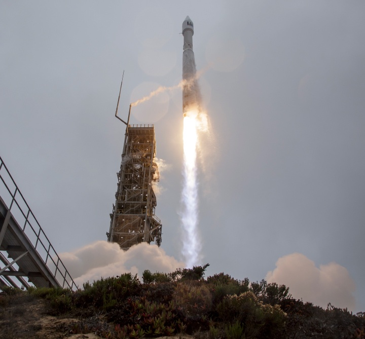
Ukrainians urge satellites to publicly share real-time images of the Russian invasion

On the morning of February 24th, after years of proxy conflict in the border region, Russia invaded the neighboring country of Ukraine. This invasion was the culmination of eight years of conflict that began with the removal of Ukrainian President Viktor Yanukovych (a long-time ally of Russian President Vladimir Putin) and Russia’s subsequent annexation of Crimea. This invasion has prompted the global community to mobilize and find ways to support Ukraine!

For instance, you have Earth Observatory System Data Analytics (EOSDA), a California-based “all-in-one cloud workspace” for Earth observation solutions. In a recent statement, EOSDA CEO Max Polyakov appealed to satellite imagery firms and space agencies worldwide to share their recent and real-time high-to-medium resolution optical and radar satellite imagery with EOSDA to assist military and humanitarian aid efforts in the region.

Continue reading “Ukrainians urge satellites to publicly share real-time images of the Russian invasion”

Tonga’s Incredible Underwater Volcano Eruption Seen From Space

The Tonga Hunga volcanic eruption sent a tsunami across the Pacific. Air pressure disturbances from the tsunami distorted GPS signals. GOES imagery courtesy NOAA,NESDIS.
The Tonga Hunga volcanic eruption as seen by a GOES satellite. Credit: NOAA,NESDIS.

An undersea volcano erupted near the Pacific island of Tonga, and several satellites caught the incredible explosion in action. The blast of the Hunga Tonga Hunga Ha’apai volcano created a  plume of ash, steam and gas mushrooming above the Pacific Ocean, with a quickly expanding shockwave visible from orbit. Japan’s Himawari-8 weather satellite recorded this dramatic video:

Continue reading “Tonga’s Incredible Underwater Volcano Eruption Seen From Space”

The Recent Killer Tornado’s Track is Visible From Space

On December 12, 2021, the Moderate Resolution Imaging Spectroradiometer (MODIS) on NASA’s Aqua satellite acquired this natural-color image of the tornado track across western Kentucky near Mayfield. This area endured some of the worst damage of the fierce storm front. Credit: NASA/NOAA.

During the night of December 10, 2021, severe weather tore through several US states, Arkansas, Illinois, Kentucky, Mississippi, Missouri and Tennessee. At least 70 tornado-like events were reported, and one storm cell was tracked on radar for approximately four hours as it traveled for more than 400 km (250 miles.)

While the destruction these storms left behind is visible even from space, the heartbreaking devastation on the ground is sobering; over 100 people killed, with hundreds more injured.

Continue reading “The Recent Killer Tornado’s Track is Visible From Space”

The Severe Pacific Northwest Flooding Seen From Space

The State of Washington and the Province of BC are in a state of emergency following days of severe wind, rain, and flooding. The situation began when an “atmospheric river” (a plume of moisture) extended over the Pacific Northwest, triggering severe rainfall that caused already-rising rivers to overflow. This led to blocked roads, mudslides, fallen bridges, and thousands of animals drowning in farmland areas.

This extensive damage was photographed from space by Earth observation satellites, one of which was the European Space Agency’s (ESA) Copernicus Sentinel mission and the International Space Station (ISS). These images captured the extent of the floods in the Nooksack and Fraser River valleys this week, which both spilled over their banks this week, leading to washed-out roads and forcing the evacuation of thousands of people.

Continue reading “The Severe Pacific Northwest Flooding Seen From Space”

Landsat 9’s First Images are Here

Landsat 9 carries two instruments designed to work together to capture a broad range of wavelengths: the Operational Land Imager 2 and the Thermal Infrared Sensor 2. Data from both instruments are shown in this image. Credits: NASA

The latest satellite in the Landsat family of Earth observation spacecraft has collected its “first light” images of our planet. Landsat 9 launched on September 27, 2021 and it continues the nearly 50-year tradition of making critical observations to help with energy and water management, forest monitoring, human and environmental health, urban planning, disaster recovery and agriculture.

Continue reading “Landsat 9’s First Images are Here”

Landsat 9 Joins a Fleet of Earth Observation Satellites

Landsat 9 lifted off from Vandenberg Space Force Base on September 27, 2021 on an an Atlas V 401 rocket. Credit: NASA

Earth has a new eye in orbit to monitor our changing planet.  

Landsat 9 launched on September 27, 2021 continuing the Landsat family of satellite’s nearly 50-year tradition of making critical observations to help with energy and water management, forest monitoring, human and environmental health, urban planning, disaster recovery and agriculture.

Continue reading “Landsat 9 Joins a Fleet of Earth Observation Satellites”

Satellite Images Can Help Predict When Underwater Volcanos are About to Erupt

Predicting volcanic eruptions is notoriously tricky. In large part this is because volcanos are unique, each with their own quirks and personalities: the lessons learned from studying one volcano may not apply directly to another. Luckily, researchers are getting better at finding warning signs that they can apply broadly. Some of the most well-known are heightened seismic activity, rising temperatures, expanding magma pools, and the release of gases. New research using satellite imagery now offers a new warning sign for underwater volcanos: a change in the color of the ocean.

Continue reading “Satellite Images Can Help Predict When Underwater Volcanos are About to Erupt”

After British Columbia’s Record-Breaking Heatwave, Here Come the Wildfires

Image taken by the Landsat 8 OLI on June 30th, 2021. Credit: NASA EO

Every day, there are more indications that show how anthropogenic factors are causing uncomfortable changes in our climate. Here in beautiful British Columbia, this means that wildfires are once again threatening countless acres of forests, communities, and wildlife. By the end of June 2021, more than 40 wildfires were raging across the province, including a rather substantial cluster around the town of Lytton.

Located just 150 km (about 93 mi) northeast of the city of Vancouver, Lytton, had to be evacuated on June 30th after an extreme heatwave led to wildfire sweeping through the area. These wildfires and the impact they were having at the time was being monitored by some of NASA’s Earth Observatory satellites. In a series of images recently shared on their website, they show the fires that were raging near Lytton just hours before the evacuation.

Continue reading “After British Columbia’s Record-Breaking Heatwave, Here Come the Wildfires”

This is Currently the World’s Largest Iceberg

An enormous iceberg has calved from the western side of the Ronne Ice Shelf, lying in the Weddell Sea, in Antarctica. Image by the Copernicus Sentinel-1 mission. Credit: ESA

A gigantic chunk of ice recently broke off from an ice shelf in Antarctica, and is currently the world’s largest iceberg. The iceberg, dubbed A-76, measures around 4,320 square km (1,670 square miles) in size. At 170 km (106 miles) in length and 25 km (15 miles) wide, the iceberg is slightly larger than the Spanish island of Majorca, and bigger than the state of Rhode Island in the US.

A-76 was captured in the above image by ESA’s Copernicus Sentinel-1 satellite. Below is an animation of the iceberg calving off the Ronne Ice Shelf.

Continue reading “This is Currently the World’s Largest Iceberg”

The Galápagos Islands From Space

A satellite image from the Copernicus Sentinel-2 mission showing the Galápagos Islands – a volcanic archipelago situated some 1000 km west of Ecuador in the Pacific Ocean. Credit: Modified Copernicus Sentinel data (2020), processed by ESA.

The Galápagos Islands hold an honored place in science history. I often wonder, if Charles Darwin could have seen this volcanic archipelago from this vantage point – a satellite view – how might have that aided or changed his research on evolution?

Continue reading “The Galápagos Islands From Space”