Curiosity’s Rambling Tracks Visible from Mars Orbit
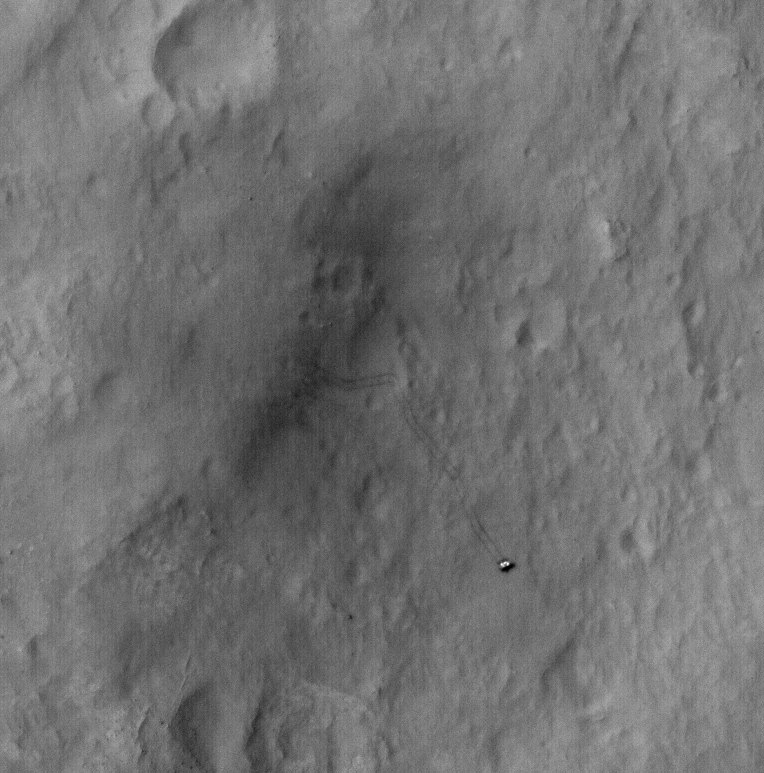
Tracks from the Curiosity rover were imaged by the HiRISE camera on the Mars Reconnaissance Orbiter on January 2, 2012. Credit: NASA/JPL/University of Arizona.
Look closely and see where the Curiosity rover has been roving about inside Gale Crater on Mars, from “Bradbury Landing” to its current location in “Yellowknife Bay.” This shot was taken by the HiRISE camera on board the Mars Reconnaissance Orbiter on January 2, 2013.
“This image shows the entire distance traveled from the landing site (dark smudge at left) to its location as of 2 January 2013 (the rover is bright feature at right),” wrote HiRISE principal investigator Alfred McEwen on the HiRISE website. “The tracks are not seen where the rover has recently driven over the lighter-toned surface, which may be more indurated [hardened] than the darker soil.”
You can compare this image to one taken on September 8, 2012 to see how much the rover has driven in Gale Crater:
And here’s a map of Curiosity’s travels that NASA released yesterday:
Mission scientists said at a briefing yesterday (January 15, 2013) that between Sol (Martian day) 120 and Sol 121 of the mission — which equates to Dec. 7 and Dec. 8, 2012 — Curiosity crossed over a terrain boundary into lighter-toned rocks that correspond to high thermal inertia values observed by NASA’s Mars Odyssey orbiter. The green dashed line marks the boundary between the terrain types.
The inset graphs the range in ground temperature recorded each day by the Rover Environmental Monitoring Station (REMS) on Curiosity. Note that the arrival onto the lighter-toned terrain corresponds with an abrupt shift in the range of daily ground temperatures to a consistently smaller spread in values. This independently signals the same transition seen from orbit, and marks the arrival at well-exposed, stratified bedrock.
Sol 124 (Dec. 11, 2012) marked the arrival into an area called “Yellowknife Bay,” where sulfate-filled veins and concretions were discovered, along with much finer-grained sediments providing evidence of past water interacting with the surface.
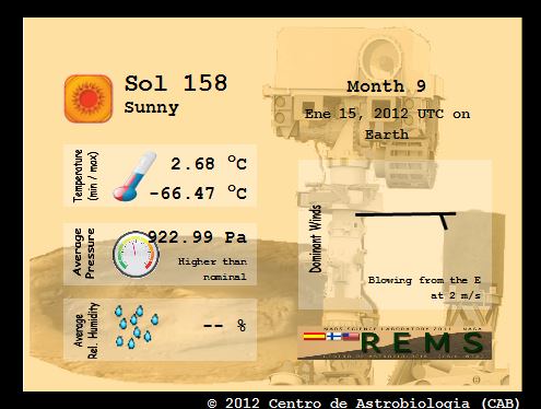
Here’s the Mars weather report provided by REMS for Sol 158 (January 15, 2013):
A video showing the new HiRISE image of Curiosity’s tracks:
Recent Posts
Enceladus’s Fault Lines are Responsible for its Plumes
The Search for Life in our Solar System leads seekers to strange places. From our…
Lunar Explorers Could Run to Create Artificial Gravity for Themselves
Few things in life are certain. But it seems highly probable that people will explore…

This is an Actual Picture of Space Debris
Space debris is a growing problem, so companies are working on ways to mitigate it.…
Insanely Detailed Webb Image of the Horsehead Nebula
Few space images are as iconic as those of the Horsehead Nebula. Its shape makes…
Binary Stars Form in the Same Nebula But Aren’t Identical. Now We Know Why.
It stands to reason that stars formed from the same cloud of material will have…
Earth Had a Magnetosphere 3.7 Billion Years Ago
We go about our daily lives sheltered under an invisible magnetic field generated deep inside…