[/caption]
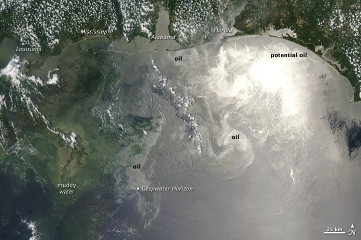
56 days into the the still-leaking Deepwater Horizon oil well spill in the Gulf of Mexico, satellite views are becoming a daily viewing habit. This latest image, taken on June 12, 2010 shows the oil particularly visible across the northern Gulf of Mexico when the Moderate Resolution Imaging Spectroradiometer (MODIS) on NASA's Aqua satellite captured this image at 1:55 p.m. CDT. Oil appears to have reached beaches and barrier islands in Alabama and the western Panhandle of Florida. The problem for wildlife, and particularly birds, is that from above, the water does not look different. And when they dive in for prey, the get soaked with oil. Estimates are that between 12,000 and 19,000 barrels a day are gushing from the damaged well. On June 3rd, BP lowered a containment cap onto a cut pipe to catch some of the flow. This cap, says the company, is now collecting more than 10,000 barrels of oil a day, ferrying it up to a tanker on the surface. But no one can be absolutely sure of the estimates.
As the oil is coming ashore along the gulf coast, everyone wonders how far the oil will travel. Researchers National Center for Atmospheric Research (NCAR) have completed a detailed computer modeling study that indicates the oil might soon extend along thousands of miles of the Atlantic coast and open ocean as early as this summer. The video of their results, captured in a series of dramatic animations, below, has caused quite a stir.
The results seem fairly dramatic, but Dr. Synte Peacock, an oceanographer at NCAR said in an interview in
EarthSky.org
on that the simulations used a dye, and not oil. A dye would travel to the Atlantic Ocean, but oil would behave differently.
However, her team still thinks it's very likely that oil will get into the Atlantic.
If it does, she said, people shouldn't expect oil to coat Atlantic beaches and wildlife. That's because, over the months it would take to travel there – if it does travel there – some oil will evaporate, be eaten by microbes, and become diluted in sea water.
Dr. Peacock added that in all the possible scenarios and simulations that were tested, oil from the oil spill traveled outside of the Gulf within 6 months. But she added that it's still unclear if or how the oil will affect beaches on the Atlantic Coast. That eventual outcome is partially dependent on local weather around the time the oil reaches a beach. [caption id="attachment_66364" align="aligncenter" width="580" caption="NASA Earth Observatory image created by Jesse Allen, using data provided courtesy of NASA/GSFC/METI/ERSDAC/JAROS, and U.S./Japan ASTER Science Team."]
[/caption]
This satellite image from the Advanced Spaceborne Thermal Emission and Reflection Radiometer (ASTER) on NASA's Terra satellite shows a false color image of on June 10, 2010, where parts of the oil slick are nearing the Mississippi Delta. Vegetation appears red and water appears in shades of blue and white.
Sources:
NASA Earth Observatory
,
EarthSky