Using archival radar images taken in the 1990s by NASA's Magellan spacecraft, scientists have found evidence of recent active volcanism on Venus. The images revealed a volcanic vent that changed shape and increased significantly in size over an eight-month period.
The scientists say their findings confirm long-held suspicions that the planet, which is known to have a very geologically young surface and evidence of past volcanic eruptions, is still active today.
"We made the discovery in the most likely place that there should have been new volcanism," said Robert Herrick, a geophysicist at the University of Alaska Fairbanks, speaking at a briefing on March 15, 2023 from the Lunar and Planetary Science Conference in Texas. "Extrapolating from a data set of one for an entire planet could be dangerous, but most scientists would say it's pretty good evidence that being able to catch an eruption in an eight-month time frame means that others are taking place as well. It confirms there is modern geological activity on Venus."
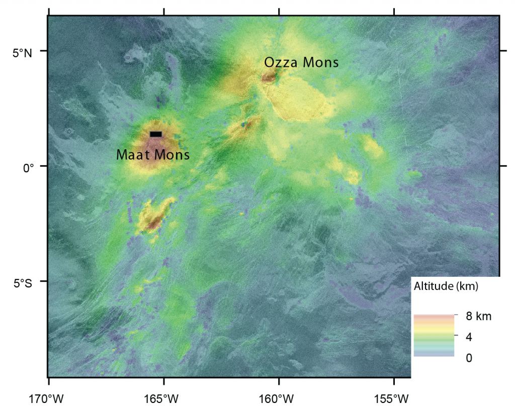
For the research Herrick teamed up with Scott Hensley, a radar scientist at NASA's Jet Propulsion Laboratory (JPL) to analyze full-resolution radar images captured by Magellan. They focused on an area containing two of Venus' largest volcanoes, Ozza Mons and Maat Mons. This area has long been thought to be volcanically active, however there has been no direct evidence of recent activity.
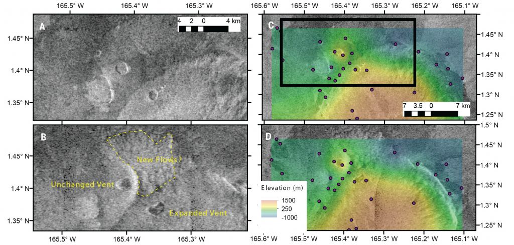
Comparing images taken in February and October 1991, they noticed that a volcanic vent measuring 2 square kilometers (0.7 square miles) showed a major change, growing considerably larger to about 4 square km (1.5 square miles.).
Herrick and Hensley then created computer models of the vent in various configurations to test different geological-event scenarios, such as landslides or other collapses. From those models, they concluded that only an eruption could have caused the change.
"Only a couple of the simulations matched the imagery, and the most likely scenario is that volcanic activity occurred on Venus' surface during Magellan's mission," Hensley said.
30 Year Old Data
The Magellan mission collected data for 4 years in 1991-1994 but only imaged the surface for 24 months of that period.
"It orbited over every place on Venus' surface three times, so once every eight months," Herrick explained, "but over the course of the mission the spacecraft's orbit was deteriorating, so the area of the planet that got imaged was reduced and changed."
Therefore, the images taken eight months apart ended up being taken at different angles and heights, Herrick said, and he compared them to images being taken from windows on different sides of a plane. That's where the computer modeling helped compare the data.
Why only now has this discovery been made?
Herrick said the purpose at the time of the mission was not to look for changes over time, but to look at as much of the planet as possible.
"You might ask, why didn't they search for something new way back when Magellan was operating? In order do this type of search for new activity, you need to be able to load in a few 100 gigabytes of datasets and be able to pan and zoom around the surface," he said. "That sort of hardware and software capability didn't really come into being until the last decade."
While the software Herrick and Hensley used is tailored for planetary science, it is similar to Google Earth or Google Maps.
Herrick said he started with a list he had created of the fifty top places that might have volcanism. "I bit the bullet and started working with the data and after about 200 hours, I hit paydirt in the area [of Maat Mons]," he said. That's when he brought in Hensley.
"Robbie approached me after he saw the change," Hensley recalled. "The Illumination differences or the shape of the topography could possibly be explained by the direction the spacecraft was looking, or how steeply it was looking. Because of the way radar imagery works, we had to filter out various artifacts, as we had to be sure. But it fits with the story of the volcanism."
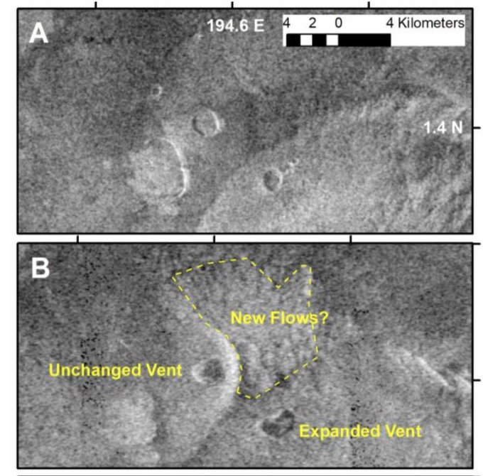
The image taken in October 1991 shows a kidney-shaped vent with collapsed walls perhaps a few hundred meters deep. Herrick also spotted a brighter patch on the ground farther downhill, which he thinks might be new lava flow that poured out of the volcano.
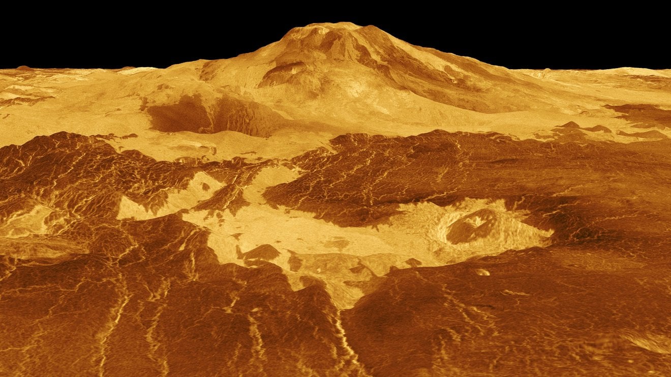
Maat Mons is located in Atla Regio, a vast highland region near Venus' equator. Herrick compared the size of the lava flow generated by the Maat Mons activity to the 2018 Kilauea eruption on the Big Island of Hawaii.
"On Hawaii, Kilauea erupts every few years" he said, "and on Venus there are volcanos that look somewhat the Big Island overall, so it's reasonable, and it leads you to a conclusion there could likely be eruptions on Venus every few months."
The Future of Venus Exploration
Can we find out more with new data? Maybe, but it will take a while, and this announcement of potential volcanos on Venus comes with a bittersweet revelation, as well. One planned mission, called VERITAS is currently in a delay, and scientists announced at LPSC that NASA has pulled funding for the mission.
After the potential finding of phosphine in Venus atmosphere, interest in Earth's sister planet has spiked. Plans were announced for a fleet of spacecraft to head to Venus by the 2030s: NASA's VERITAS (Venus Emissivity, Radio Science, InSAR, Topography and Spectroscopy) and DAVINCI (Deep Atmosphere Venus Investigation of Noble gases, Chemistry and Imaging) and Europe's EnVision missions.
DAVINCI will send an atmospheric probe into Venus' clouds, and VERITAS and EnVision are to peer through the planet's thick atmosphere from orbit, able to determine very small changes" on the planet's surface, more than ten times better than the resolution of Magellan.
DAVINCI is slated to launch in 2029. NASA recently announced a delay for VERITAS and it is now scheduled to launch between 2032 to 2034, followed closely by EnVision, which will fly between 2035 to 2039.
However, Sue Smrekar the Principal Investigator of the VERITAS mission has confirmed at the Venus Exploration Analysis Group (VEXAG) town hall at LPSC that NASA pulled all funding for her mission, except for $1.5M for the science team. The ramifications of that announcement have yet to be known in full.
