
Is this a closeup look at a tree stump, or an orbital view of an impact crater? At first glance, it might be hard to tell. But this image of a crater on Mars provides planetary scientists almost the same kind of climate history data about the Red Planet as tree rings provide to climate scientists here on Earth.
This picture was taken by the Colour and Stereo Surface Imaging (CaSSIS) camera onboard the ESA/Roscosmos ExoMars Trace Gas Orbiter (TGO), which arrived at Mars in 2016 and began its full science mission in 2018.
This unnamed crater is located in the vast northern plains of Acidalia Planitia. This plain is north of Valles Marineris, and the region contains the famous Cydonia region (where the "Face on Mars" butte is (it aoesn't actually look like a face), and well as heavily cratered highland terrain.
So, why does this crater look so unusual? Scientist from the ExoMars mission say the interior of the crater is likely composed of ice-rich material, and the quasi-circular and polygonal patterns of fractures could be the result of seasonal changes in temperature that cause cycles of expansion and contraction of those materials, eventually leading to the development of fractures.
Along the crater rim on the left, possible gullies are also visible.
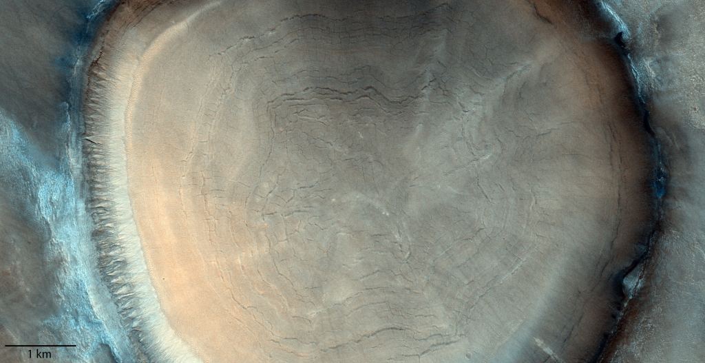
Any water-ice rich soil would have been laid down during an earlier time in Mars' history when the inclination of the planet's spin axis allowed such deposits to form at lower latitudes than it does today. Just like on Earth, Mars' tilt gives rises to seasons, but unlike Earth its tilt has changed dramatically over long periods of time.
"Understanding the history of water on Mars and if this once allowed life to flourish is at the heart of ESA's ExoMars missions," say mission scientists. "The spacecraft is not only returning spectacular images, but also providing the best ever inventory of the planet's atmospheric gases with a particular emphasis on geologically and biologically important gases, and mapping the planet's surface for water-rich locations."
The ExoMars orbiter will also provide data relay services for the second ExoMars mission which has the Russian built Kazachok lander that will bring the Rosalind Franklin rover to the surface of Mars. That mission is scheduled to launch in September of 2022. When it arrives on Mars in 2023, the rover will explore another region of Mars – not yet disclosed -- thought once to have hosted an ancient ocean, and will search underground for signs of life.
Source: ESA
