Does the life of an astronomer or planetary scientists seem exciting?
Sitting in an observatory, sipping warm cocoa, with high-tech tools at your disposal as you work diligently, surfing along on the wavefront of human knowledge, surrounded by fine, bright people. Then one day—Eureka!—all your hard work and the work of your colleagues pays off, and you deliver to humanity a critical piece of knowledge. A chunk of knowledge that settles a scientific debate, or that ties a nice bow on a burgeoning theory, bringing it all together. Conferences...tenure...Nobel Prize?
Well, maybe in your first year of university you might imagine something like that. But science is work. And as we all know, not every minute of one's working life is super-exciting and gratifying.
Sometimes it can be dull and repetitious.
It's probably not anyone's dream, when they begin their scientific education, to sit in front of a computer poring over photos of the surface of Mars, counting the craters. But someone has to do it. How else would we all know how many craters there are?
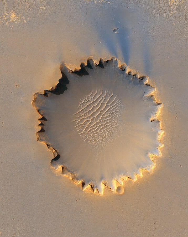
Mars is the subject of intense scientific scrutiny. Telescopes, rovers, and orbiters are all working to unlock the planet's secrets. There are a thousand questions concerning Mars, and one part of understanding the complex planet is understanding the frequency of meteorite strikes on its surface.
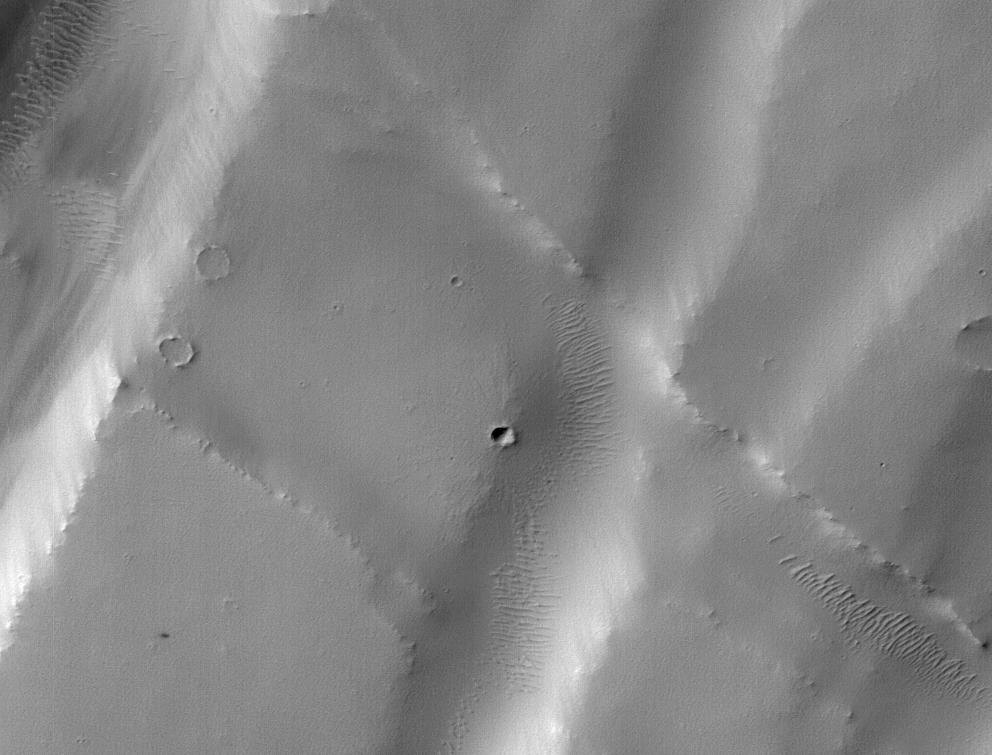
NASA's Mars Reconnaissance Orbiter (MRO) has been orbiting Mars for 14.5 years now. Along with the rest of its payload, the MRO carries cameras. One of them is called the Context (CTX) Camera. As its name says, it provides context for the other cameras and instruments.
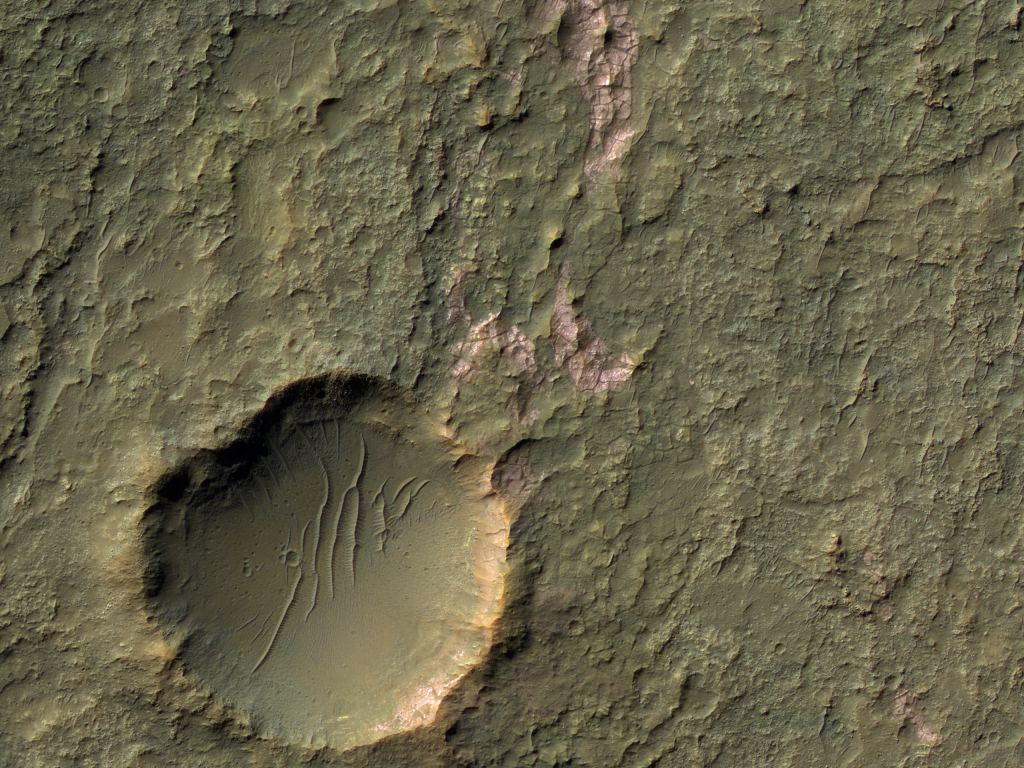
MRO's powerhouse camera is called HiRISE (High-Resolution Imaging Science Experiment). While the CTX camera takes wider view images, HiRISE zooms in to take precision images of details on the surface. The pair make a potent team, and HiRISE has treated us to more gorgeous and intriguing pictures of Mars than any other instrument.
But the cameras are kind of "dumb" in a scientific sense. It takes a human being to go over the images. As a NASA press release tells us, it can take 40 minutes for one researcher to go over a CTX image, hunting for small craters. Over the lifetime of the MRO so far, researchers have found over 1,000 craters this way. They're not just looking for craters, they're interested in any changes on the surface: dust devils, shifting dunes, landslides, and the like.
AI researchers at NASA's Jet Propulsion Laboratory in Southern California have been trying to do something about all the time it takes to find things of interest in all of these images. They're developing a machine learning tool to handle some of that workload. On August 26th, 2020, the tool had its first success.
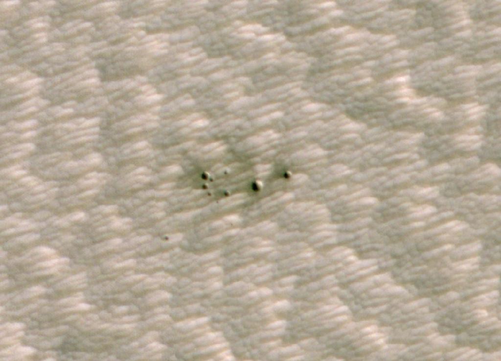
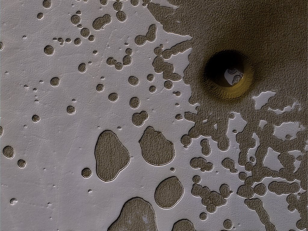
On some date between March 2010 and May 2012, a meteor slammed into Mars' thin atmosphere. It broke into several pieces before it struck the surface, creating what looks like nothing more than a black speck in CTX camera images of the area. The new AI tool, called an automated fresh impact crater classifier, found it. Once it did, NASA used HiRISE to confirm it.
That was the classifier's first find, and in the future, NASA expects AI tools to do more of this kind of work, freeing human minds up for more demanding thinking. The crater classifier is part of a broader JPL effort named COSMIC (Capturing Onboard Summarization to Monitor Image Change). The goal is to develop these technologies not only for MRO, but for future orbiters. Not only at Mars, but wherever else orbiters find themselves.
Machine learning tools like the crater classifier have to be trained. For its training, it was fed 6,830 CTX camera images. Among those images were ones containing confirmed craters, and others that contained no craters. That taught the tool what to look for and what not to look for.
Once it was trained, JPL took the system's training wheels off and let it loose on over 110,000 images of the Martian surface. JPL has its own supercomputer, a cluster containing dozens of high-performance machines that can work together. The result? The AI running on that powerful machine took only five seconds to complete a task that takes a human about 40 minutes. But it wasn't easy to do.
"It wouldn't be possible to process over 112,000 images in a reasonable amount of time without distributing the work across many computers," said JPL computer scientist Gary Doran, in a press release. "The strategy is to split the problem into smaller pieces that can be solved in parallel."
But while the system is powerful, and represents a huge savings of human time, it can't operate without human oversight.
"AI can't do the kind of skilled analysis a scientist can," said JPL computer scientist Kiri Wagstaff. "But tools like this new algorithm can be their assistants. This paves the way for an exciting symbiosis of human and AI 'investigators' working together to accelerate scientific discovery."
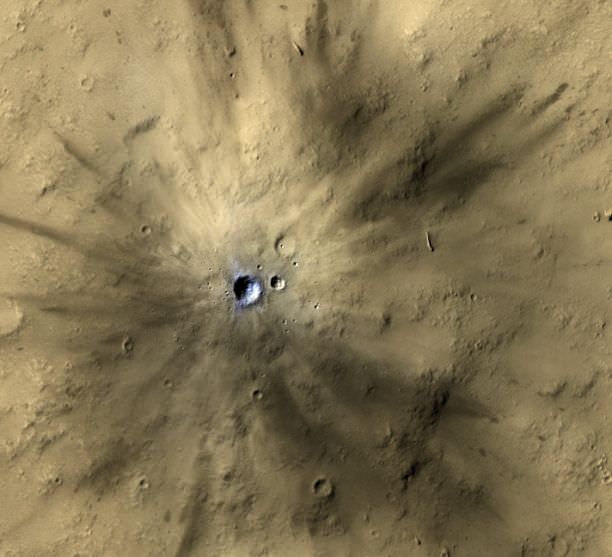
Once the crater finder scores a hit in a CTX camera image, it's up to HiRISE to confirm it. That happened on August 26th, 2020. After the crater finder flagged a dark smudge in a CTX camera image of a region named Noctis Fossae, the power of the HiRISE took scientists in for a closer look. That confirmed the presence of not one crater, but a cluster of several resulting from the objects that struck Mars between March 2010 and May 2012.
With that initial success behind them, the team developing the AI has submitted more than 20 other CTX images to HiRISE for verification.
This type of software system can't run on an orbiter, yet. Only an Earth-bound supercomputer can perform this complex task. All of the data from CTX and HiRISE is sent back to Earth, where researchers pore over it, looking for images of interest. But the AI researchers developing this system hope that will change in the future.
"The hope is that in the future, AI could prioritize orbital imagery that scientists are more likely to be interested in," said Michael Munje, a Georgia Tech graduate student who worked on the classifier as an intern at JPL.
There's another important aspect to this development. It shows how older, still-operational spacecraft can be sort of re-energized with modern technological power, and how scientists can wring even more results from them.
Ingrid Daubar is one of the scientists working on the system. She thinks that this new tool will help find more craters that are eluding human eyes. And if it can, it'll help build our knowledge of the frequency, shape, and size of meteor strikes on Mars.
"There are likely many more impacts that we haven't found yet," Daubar said. "This advance shows you just how much you can do with veteran missions like MRO using modern analysis techniques."
"Observe Much, Return Best"
This new machine learning tool is part of a broader-based NASA/JPL initiative called COSMIC (Content-based On-board Summarization to Monitor Infrequent Change.) That initiative has a motto: Observe much, return best.
The idea behind COSMIC is to "create a robust, flexible orbital system for conducting planetary surveys and change monitoring in the Martian environment." Due to bandwidth considerations, many images are never downloaded to Earth. Among other goals, the system will autonomously detect "changes in non-monitored areas, and provide relevant, informative descriptions of onboard images to advise downlink prioritization." The AI that finds craters is just one component of the system.
Data management is a huge and growing challenge in science. Other missions like NASA's Kepler planet-hunting spacecraft generated an enormous amount of data. In an effort that parallels what COSMIC is trying to do, scientists are using new methods to comb through all of Kepler's data, sometimes finding exoplanets that were missed in the original analysis.
And the upcoming Vera C. Rubin Survey Telescope will be another data-generating monster. In fact, managing all of its data is considered to be the most challenging part of that entire project. It'll generate about 200,000 images per year, or about 1.28 petabytes of raw data. That's far more data than humans will be able to deal with.
In anticipation of so much data, the people behing the Rubin Telescope developed the the LSSTC Data Science Fellowship Program. It's a two-year program designed for grad school curriculums that will explore topics including statistics, machine learning, information theory, and scalable programming.
It's clear that AI and machine learning will have to play a larger role in space science. In the past, the amount of data returned by space missions was much more manageable. The instruments gathering the data were simpler, the cameras were much lower resolution, and the missions didn't last as long (not counting the Viking missions.)
And though a system designed to find small craters on the surface of Mars might not capture the imagination of most people, it's indicative of what the future will hold.
One day, more scientists will be freed from sitting for hours at a time going over images. They'll be able to delegate some of that work to AI systems like COSMIC and its crater finder.
We'll probably all benefit from that.
More:
- Press Release: AI Is Helping Scientists Discover Fresh Craters on Mars
- NASA: Mars Reconnaissance Orbiter
- Universe Today: A Meteor Smashed Into Mars in 2005, Making this Crater