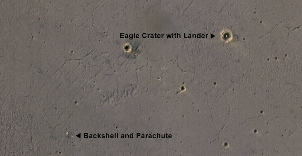
NASA's eagle-eyed Mars Reconnaissance Orbiter (MRO) has captured orbital images of Opportunity's Hole-In-One landing site, smack dab in the middle of Eagle Crater on the surface of Mars.
Opportunity arrived at Mars on January 25th, 2005. It's landing was slowed by parachute, and cushioned by airbags. Once it hit the surface, it bounced its way into "
Eagle Crater
", a feature a mere 22 meters across. Not a bad shot!
This is the first color image that the High Resolution Imaging Science Experiment (HiRise) has captured of Opportunity's landing site. It shows the remarkable landing site inside the crater, where the landing pad was left behind after Opportunity rolled off of it and got going. It also shows the rover's parachute and backshell.
It's amazing that, given the relatively smooth surface in Opportunity's landing area, the rover came to rest inside a small crater. When Opportunity "woke up" at its landing site, its first images were of the inside of Eagle Crater. This was the first look we ever got at the sedimentary rocks on Mars, taken by the rover's navigation camera.
[caption id="attachment_135171" align="alignnone" width="512"]
Opportunity's navigation camera took this picture, one of the rover's first, of the inside of Eagle Crater. Exposed Martian rocks are visible. NASA/JPL[/caption]
After leaving Eagle Crater, Opportunity took a look back and captured a panoramic image. Plainly visible is the rover's landing pad, the exposed sedimentary rock, and the rover's tracks in the Martian soil.
[caption id="attachment_135173" align="alignnone" width="900"]
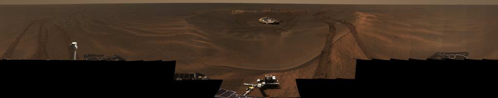
This panorama image, called "Lion King" was assembled from 558 images totalling over 75 megabytes. The rock outcrop, the landing pad, and the rover's tracks are all clearly visible. Image: NASA/JPL/Cornell[/caption]
MRO arrived at Mars a couple years later, and by that time Opportunity had already left its landing site and made its way south to the much larger
Victoria Crater
.
[caption id="attachment_135168" align="alignnone" width="461"]
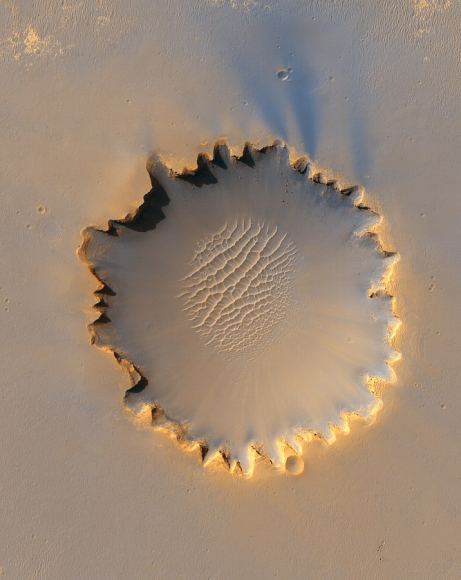
When the Mars Reconnaissance Orbiter arrived at Mars, 2 years after Opportunity touched down there, Opportunity had left Eagle Crater and travelled the 6 km to Victoria Crater. By NASA/JPL/University of Arizona - http://photojournal.jpl.nasa.gov/catalog/PIA08813, Public Domain, https://commons.wikimedia.org/w/index.php?curid=4211043[/caption]
Opportunity
is still chugging along, doing valuable work. And so is the
MRO
and its
HiRise
instrument. At this point, Opportunity has to be considered one of the most successful scientific undertakings ever.