Opportunity's final image before the global dust storm ended the rover's mission on Mars. Image Credit: NASA/JPL-Caltech/Cornell/ASU
Opportunity’s final message home is not much to look at on its own. If you’re old enough to remember film cameras, it looks like the final exposure on a roll of film, developed but partly missing. It’s a suitable epitaph for Opportunity’s mission.
NASA has shared Opportunity’s final photograph from the surface of Mars. The rover’s final resting place is in Endeavour Crater, and barring any statistically unlikely event, it will sit there for centuries, millennia, or even longer. And instead of a tombstone, we have this final image.
NASA’s Opportunity rover has reached the end of its life. Initially designed to last 90 days, and to travel only 1000 meters (1100 yards), the rover spent almost 15 years exploring the surface of Mars. During that time, it travelled more than 45 kilometers (28 miles.)
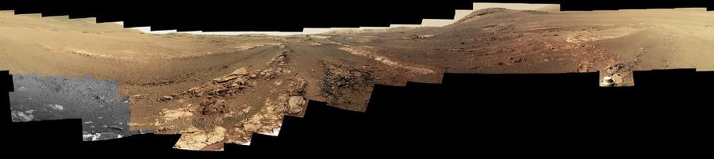
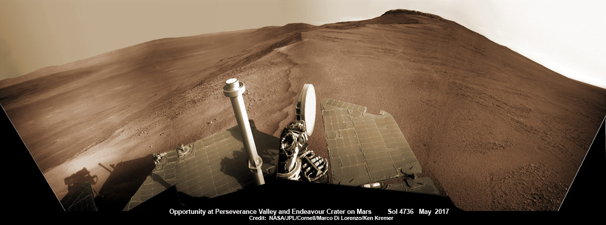
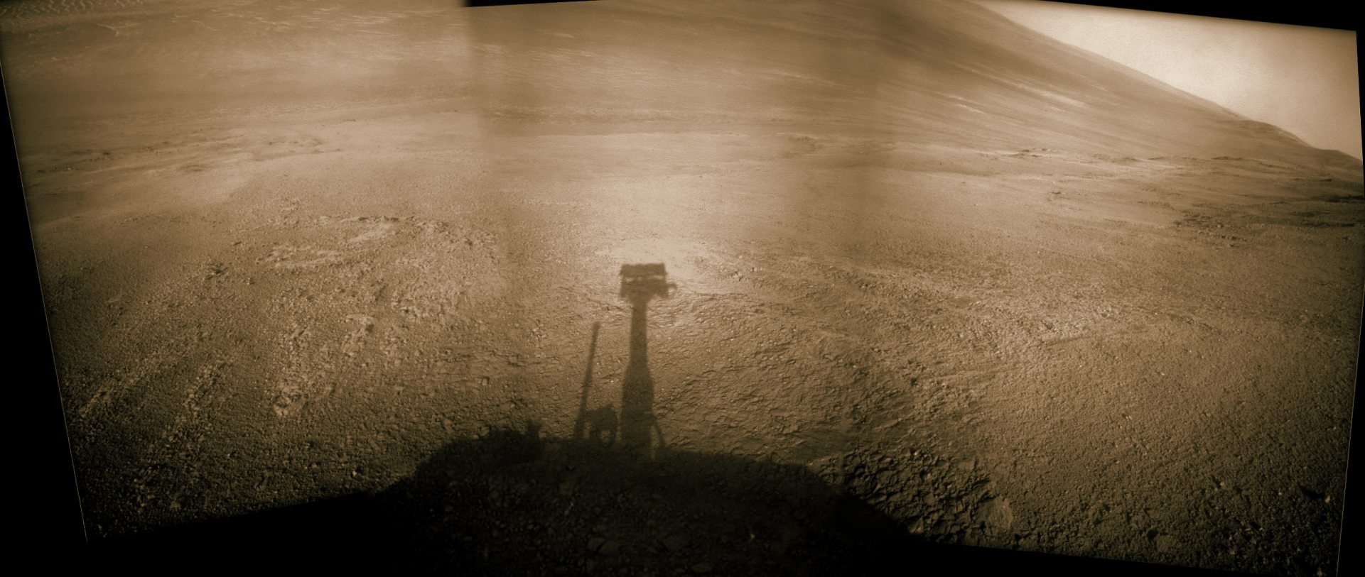
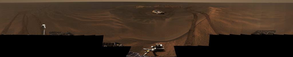
Opportunity rover looks south from the top of Perseverance Valley along the rim of Endeavour Crater on Mars in this partial self portrait including the rover deck and solar panels. Perseverance Valley descends from the right and terminates down near the crater floor. This navcam camera photo mosaic was assembled from raw images taken on Sol 4736 (20 May 2017) and colorized. Credit: NASA/JPL/Cornell/Marco Di Lorenzo/Ken Kremer/kenkremer.com
Could this be the end of the Opportunity rover? There’s been no signal from the rover since last summer, when a massive global dust storm descended on it. But even though the craft has been silent and unreachable for six-and-a-half months, NASA hasn’t given up.
When Opportunity landed at Meridiani Planum on Mars in January 2004, it’s planned mission length was only 90 days. Since that day, which seems so long ago now, 15 years have passed, and over one billion people have been born on Earth. Six months ago, the rover stopped working, maybe for good. So by every measure, Opportunity has been a stunning success.
This global map of Mars shows a growing dust storm as of June 6, 2018. The map was produced by the Mars Color Imager (MARCI) camera on NASA's Mars Reconnaissance Orbiter spacecraft. The blue dot indicates the approximate location of Opportunity. Image Credit: NASA/JPL-Caltech/MSSS
NASA’s Opportunity mission can rightly be called the rover that just won’t quit. Originally, this robotic rover was only meant to operate on Mars for 90 Martian days (or sols), which works out to a little over 90 Earth days. However, since it made its landing on January 25th, 2004, it has remained in operation for 14 years, 4 months, and 18 days – exceeding its operating plan by a factor of 50!
However, a few weeks ago, NASA received disturbing news that potentially posed a threat to the “little rover that could”. A Martian storm, which has since grown to occupy an area larger than North America – 18 million km² (7 million mi²) – was blowing in over rover’s position in the Perseverance Valley. Luckily, NASA has since made contact with the rover, which is encouraging sign.
NASA’s Mars Reconnaissance Orbiter first detected the storm on Friday, June 1st, and immediately notified the Opportunity team to begin preparing contingency plans. The storm quickly grew over the next few days and resulted in dust clouds that raised the atmosphere’s opacity, which blocked out most of the sunlight from reaching the surface. This is bad news for the rover since it relies on solar panels for power and to recharge its batteries.
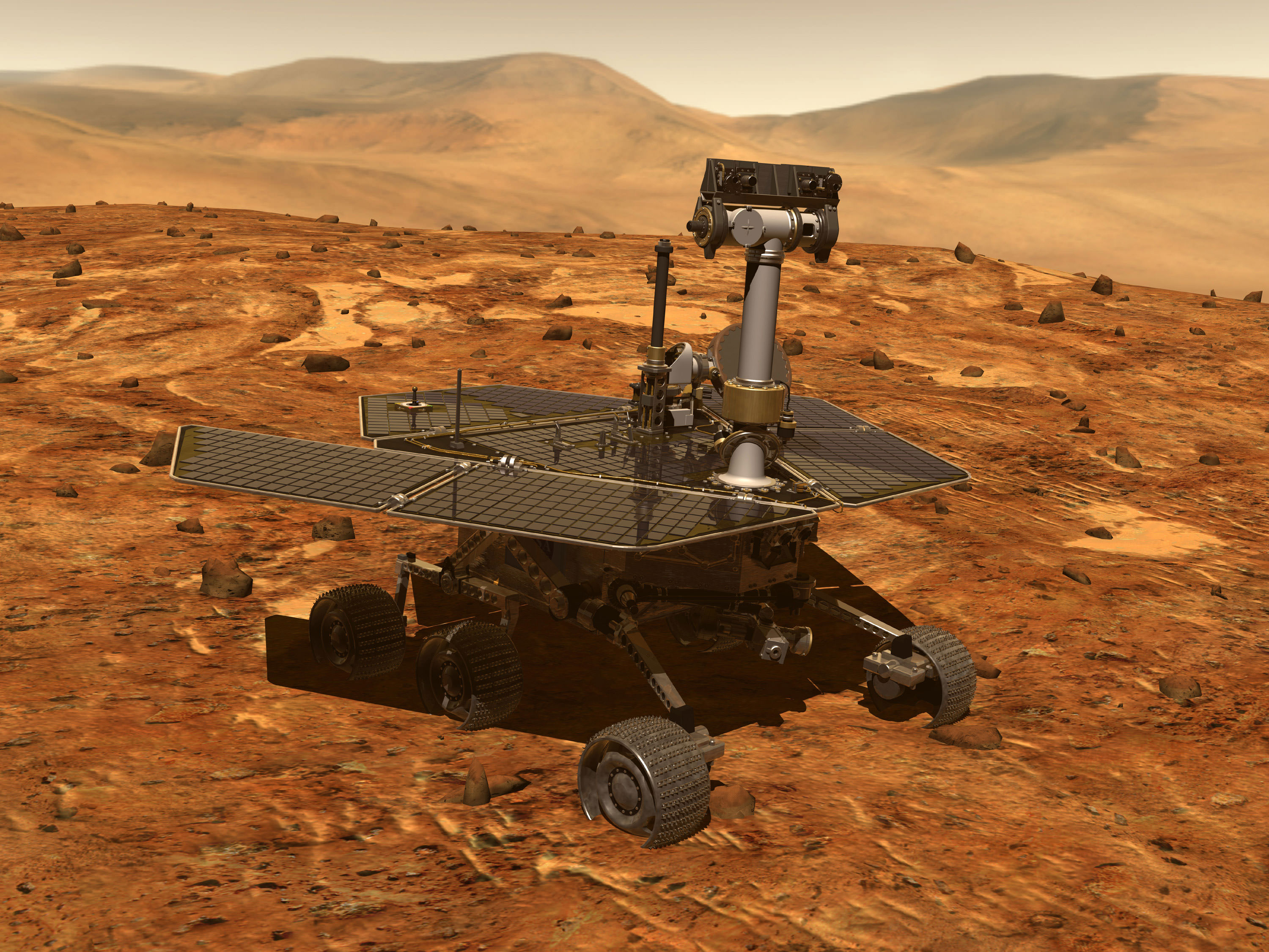
Artist’s conception of a Mars Exploration Rover, which included Opportunity and Spirit. Credit: NASA
By Wednesday, June 6th, Opportunity’s power levels had dropped significantly and the rover was required to shift to minimal operations. But beyond merely limiting the rover’s operations, a prolonged dust storm also means that the rover might not be able to keep its energy-intensive survival heaters running – which protect its batteries from the extreme cold of Mars’ atmosphere.
The Martian cold is believed to be what resulted in the loss of the Spirit rover in 2010, Opportunity’s counterpart in the Mars Exploration Rover mission. Much like Opportunity, Spirit‘s mission as only meant to last for 90 days, but the rover managed to remain in operation for 2269 days (2208 sols) from start to finish. It’s also important to note that Opportunity has dealt with long-term storms before and emerged unscathed.
Back in 2007, a much larger storm covered the planet, which led to two weeks of minimal operations and no communications. However, the current storm has intensified as of Sunday morning (June 10th), creating a perpetual state of night over the rover’s location in Perseverance Valley and leading to a level of atmospheric opacity that is much worse than the 2007 storm.
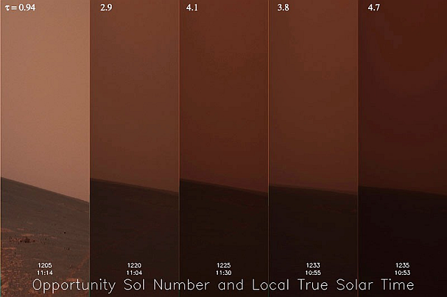
Whereas the previous storm had an opacity level (tau) of about 5.5, this new storm has an estimated tau of 10.8. Luckily, NASA engineers received a transmission from the rover on Sunday, which was a positive indication since it proved that the rover still has enough battery charge to communicate with controllers at NASA’s Jet Propulsion Laboratory. This latest transmission also showed that the rover’s temperature had reached about -29 °C (-20 °F).
This 30-day time-lapse of the Martian atmosphere was capture by Opportunity during the 2007 dust storm. Credit: NASA/JPL-Caltech/Cornell
Full dust storms like this and the one that took place in 2007 are rare, but not surprising. They occur during summer in the southern hemisphere, when sunlight warms dust particles and lifts them higher into the atmosphere, creating more wind. That wind kicks up yet more dust, creating a feedback loop that NASA scientists are still trying to understand. While they can begin suddenly, they tend to last on the order of weeks or even months.
A saving grace about these storms is that they limit the extreme temperature swings, and the dust they kick up can also absorb solar radiation, thus raising ambient temperatures around Opportunity. In the coming weeks, engineers at the JPL will continue to monitor the rover’s power levels and ensure that it maintains the proper balance to keep its batteries in working order.
In the meantime, Opportunity’s science operations remain suspended and the Opportunity team has requested additional communications coverage from NASA’s Deep Space Network – the global system of antennas that communicates with all of the agency’s deep space missions. And if there’s one thing Opportunity has proven, it is that it’s capable of enduring!
Fingers crossed the storm subsides as soon as possible and the little rover that could once again emerges unscathed. At this rate, it could have many more years of life left in it!
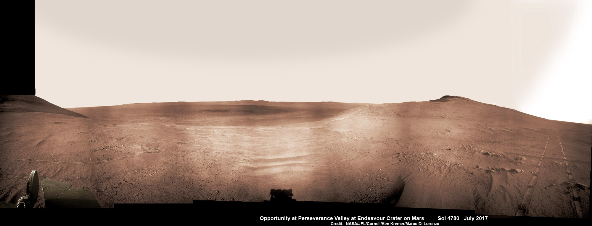
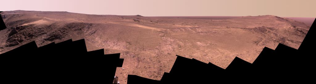
Historic 1st descent down Martian gully. Panoramic view looking down Perseverance Valley after entry at top was acquired by NASA’s Opportunity rover scanning from north to south. It shows numerous wheel tracks at left, center and right as rover conducted walkabout tour prior to starting historic first decent down a Martian gully - possibly carved by water - and looks into the interior of Endeavour crater. Perseverance Valley terminates down near the crater floor in the center of the panorama. The far rim of Endeavour crater is seen in the distance, beyond the dark floor. Rover mast shadow at center and deck at left. This navcam camera photo mosaic was assembled by Ken Kremer and Marco Di Lorenzo from raw images taken on Sol 4780 (5 July 2017) and colorized. Credit: NASA/JPL/Cornell/Ken Kremer/kenkremer.com/Marco Di Lorenzo
Historic 1st descent down Martian gully. Panoramic view looking down Perseverance Valley after entry at top was acquired by NASA’s Opportunity rover scanning from north to south. It shows numerous wheel tracks at left, center and right as rover conducted walkabout tour prior to starting historic first decent down a Martian gully – possibly carved by water – and looks into the interior of Endeavour crater. Perseverance Valley terminates down near the crater floor in the center of the panorama. The far rim of Endeavour crater is seen in the distance, beyond the dark floor. Rover mast shadow at center and deck at left. This navcam camera photo mosaic was assembled by Ken Kremer and Marco Di Lorenzo from raw images taken on Sol 4780 (5 July 2017) and colorized. Credit: NASA/JPL/Cornell/Ken Kremer/kenkremer.com/Marco Di Lorenzo
From the precipice of “Perseverance Valley” NASA’s teenaged Red Planet robot Opportunity has begun the historic first ever descent of an ancient Martian gully – that’s simultaneously visually and scientifically “tantalizing” – on an expedition to discern ‘How was it carved?’; by water or other means, Jim Green, NASA’s Planetary Sciences Chief tells Universe Today.
Since water is an indispensable ingredient for life as we know it, the ‘opportunity’ for Opportunity to study a “possibly water-cut” gully on Mars for the first time since they were discovered over four decades ago by NASA orbiters offers a potential scientific bonanza.
“Gullies on Mars have always been of intense interest since first observed by our orbiters,” Jim Green, NASA’s Planetary Sciences Chief explained to Universe Today.
“How were they carved? muses Green. “Water is a natural explanation but this is another planet. Now we have a chance to find out for real!”
Their origin and nature has been intensely debated by researchers for decades. But until now the ability to gather real ‘ground truth’ science by robotic or human explorers has remained elusive.
“This will be the first time we will acquire ground truth on a gully system that just might be formed by fluvial processes,” Ray Arvidson, Opportunity Deputy Principal Investigator of Washington University in St. Louis, told Universe Today.
“Perseverance Valley” is located along the eroded western rim of gigantic Endeavour crater – as illustrated by our exclusive photo mosaics herein created by the imaging team of Ken Kremer and Marco Di Lorenzo.
After arriving at the upper entryway to “Perseverance Valley” the six wheeled rover drove back and forth to gather high resolution imagery of the inner slope for engineers to create a 3D elevation map and plot a safe driving path down – as illustrated in our lead mosaic showing the valley and extensive wheel tracks at left, center and right.
Having just this week notched an astounding 4800 Sols roving the Red Planet, NASA’s resilient Opportunity rover has started driving down from the top of “Perseverance Valley” from the spillway overlooking the upper end of the ancient fluid-carved Martian valley into the unimaginably vast eeriness of alien Endeavour crater.
Water, ice or wind may have flowed over the crater rim and into the crater from the spillway.
“It is a tantalizing scene,” said Opportunity Deputy Principal Investigator Ray Arvidson of Washington University in St. Louis, in a statement. “You can see what appear to be channels lined by boulders, and the putative spillway at the top of Perseverance Valley. We have not ruled out any of the possibilities of water, ice or wind being responsible.”
Toward the right side of this scene is a broad notch in the crest of the western rim of Endeavour Crater. Wheel tracks in that area were left by NASA’s Mars Exploration Rover Opportunity as it observed “Perseverance Valley” from above in the spring of 2017. The valley is a major destination for the rover’s extended mission. It descends out of sight on the inner slope of the rim, extending down and eastward from that notch. The component pancam images for this view from a position outside the crater were taken during the span of June 7 to June 19, 2017, sols 4753 to 4765. Credit: NASA/JPL-Caltech/Cornell/Arizona State Univ.
“With the latest drive on sol 4782, Opportunity began the long drive down the floor of Perseverance Valley here on Endeavour crater, says Larry Crumpler, a rover science team member from the New Mexico Museum of Natural History & Science.
“This is rather historic in that it represents the first time that a rover has driven down an apparent water-cut valley on Mars. Over the next few months Opportunity will explore the floor and sides of the valley for evidence of the scale and timing of the fluvial activity, if that is what is represents.”
This mosaic view looks down from inside the upper end of “Perseverance Valley” on the inner slope of Endeavour Crater’s western rim after Opportunity started driving down the Martian gully. The scene behind the shadow of the rover’s mast shows Perseverance Valley descending to the floor of Endeavour Crater. This navcam camera photo mosaic was assembled from raw images taken on Sol 4782 (7 July 2017) and colorized. Credit: NASA/JPL/Cornell/Marco Di Lorenzo/Ken Kremer/kenkremer.com
NASA’s unbelievably long lived Martian robot reached a “spillway” at the top of “Perseverance Valley” in May after driving southwards for weeks from the prior science campaign at a crater rim segment called “Cape Tribulation.”
“Investigations in the coming weeks will “endeavor” to determine whether this valley was eroded by water or some other dry process like debris flows,” explains Crumpler.
“It certainly looks like a water cut valley. But looks aren’t good enough. We need additional evidence to test that idea.”
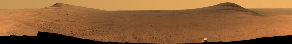
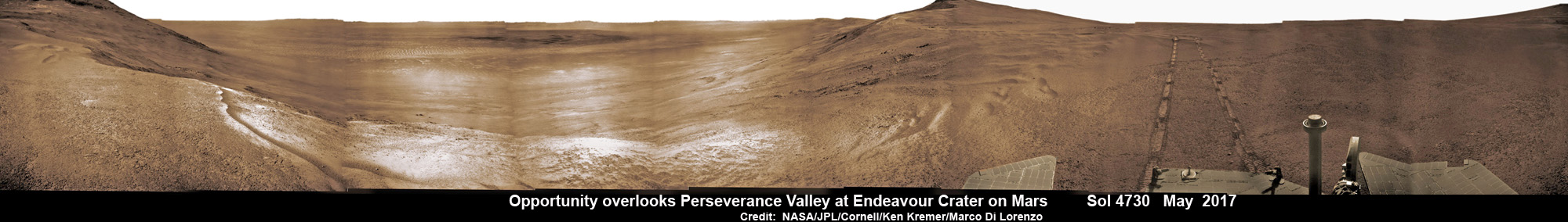
NASA’s Opportunity rover acquired this Martian panoramic view from a promontory that overlooks Perseverance Valley below – scanning from north to south. It is centered on due East and into the interior of Endeavour crater. Perseverance Valley descends from the right and terminates down near the crater floor in the center of the panorama. The far rim of Endeavour crater is seen in the distance, beyond the dark floor. Rover deck and wheel tracks at right. This navcam camera photo mosaic was assembled from raw images taken on Sol 4730 (14 May 2017) and colorized. Credit: NASA/JPL/Cornell/Ken Kremer/kenkremer.com/Marco Di Lorenzo
The valley slices downward from the crest line through the rim from west to east at a breathtaking slope of about 15 to 17 degrees – and measures about two football fields in length!
Huge Endeavour crater spans some 22 kilometers (14 miles) in diameter on the Red Planet. Perseverance Valley slices eastwards at approximately the 8 o’clock position of the circular shaped crater. It sits just north of a rim segment called “Cape Byron.”
Why go and explore the gully at Perseverance Valley?
“Opportunity will traverse to the head of the gully system [at Perseverance] and head downhill into one or more of the gullies to characterize the morphology and search for evidence of deposits,” Arvidson elaborated to Universe Today.
“Hopefully test among dry mass movements, debris flow, and fluvial processes for gully formation. The importance is that this will be the first time we will acquire ground truth on a gully system that just might be formed by fluvial processes. Will search for cross bedding, gravel beds, fining or coarsening upward sequences, etc., to test among hypotheses.”
Exploring the ancient valley is the main science destination of the current two-year extended mission (EM #10) for the teenaged robot, that officially began Oct. 1, 2016. It’s just the latest in a series of extensions going back to the end of Opportunity’s prime mission in April 2004.
Before starting the gully descent, Opportunity conducted a walkabout at the top of the Perseverance Valley in the spillway to learn more about the region before driving down.
“The walkabout is designed to look at what’s just above Perseverance Valley,” said Opportunity Deputy Principal Investigator Ray Arvidson of Washington University in St. Louis, in a statwemwent. “We see a pattern of striations running east-west outside the crest of the rim.”
“We want to determine whether these are in-place rocks or transported rocks,” Arvidson said. “One possibility is that this site was the end of a catchment where a lake was perched against the outside of the crater rim. A flood might have brought in the rocks, breached the rim and overflowed into the crater, carving the valley down the inner side of the rim. Another possibility is that the area was fractured by the impact that created Endeavour Crater, then rock dikes filled the fractures, and we’re seeing effects of wind erosion on those filled fractures.”
Opportunity rover looks south from the top of Perseverance Valley along the rim of Endeavour Crater on Mars in this partial self portrait including the rover deck and solar panels. Perseverance Valley descends from the right and terminates down near the crater floor. This navcam camera photo mosaic was assembled from raw images taken on Sol 4736 (20 May 2017) and colorized. Credit: NASA/JPL/Cornell/Marco Di Lorenzo/Ken Kremer/kenkremer.com
Having begun the long awaited gully descent, further movements are temporarily on hold since the start of the solar conjunction period which blocks communications between Mars and Earth for about the next two weeks, since Mars is directly behind the sun.
In the meantime, Opportunity will still collect very useful panoramic images and science data while standing still.
The solar conjunction moratorium on commanding extends from July 22 to Aug. 1, 2017.
As of today, July 27, 2017, long lived Opportunity has survived over 4800 Sols (or Martian days) roving the harsh environment of the Red Planet.
Opportunity has taken over 221,625 images and traversed over 27.95 miles (44.97 kilometers.- more than a marathon.
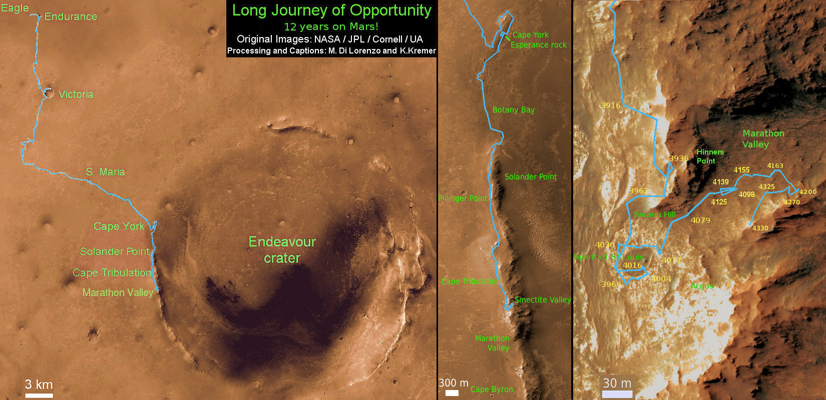
See our updated route map below. It shows the context of the rovers over 13 year long traverse spanning more than the 26 mile distance of a Marathon runners race.
The rover surpassed the 27 mile mark milestone on November 6, 2016 (Sol 4546) and will soon surpass the 28 mile mark.
As of Sol 4793 (July 18, 2017) the power output from solar array energy production is currently 332 watt-hours with an atmospheric opacity (Tau) of 0.774 and a solar array dust factor of 0.534, before heading into another southern hemisphere Martian winter later in 2017. It will count as Opportunity’s 8th winter on Mars.
Meanwhile Opportunity’s younger sister rover Curiosity traverses up the lower sedimentary layers at the base of Mount Sharp.
And NASA continues building the next two robotic missions due to touch down in 2018 and 2020.
NASA as well is focusing its human spaceflight efforts on sending humans on a ‘Journey to Mars’ in the 2030s with the Space Launch System (SLS) mega rocket and Orion deep space crew capsule.
Stay tuned here for Ken’s continuing Earth and planetary science and human spaceflight news.
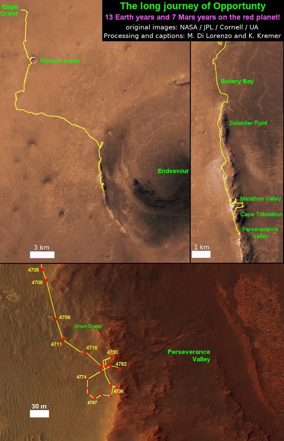
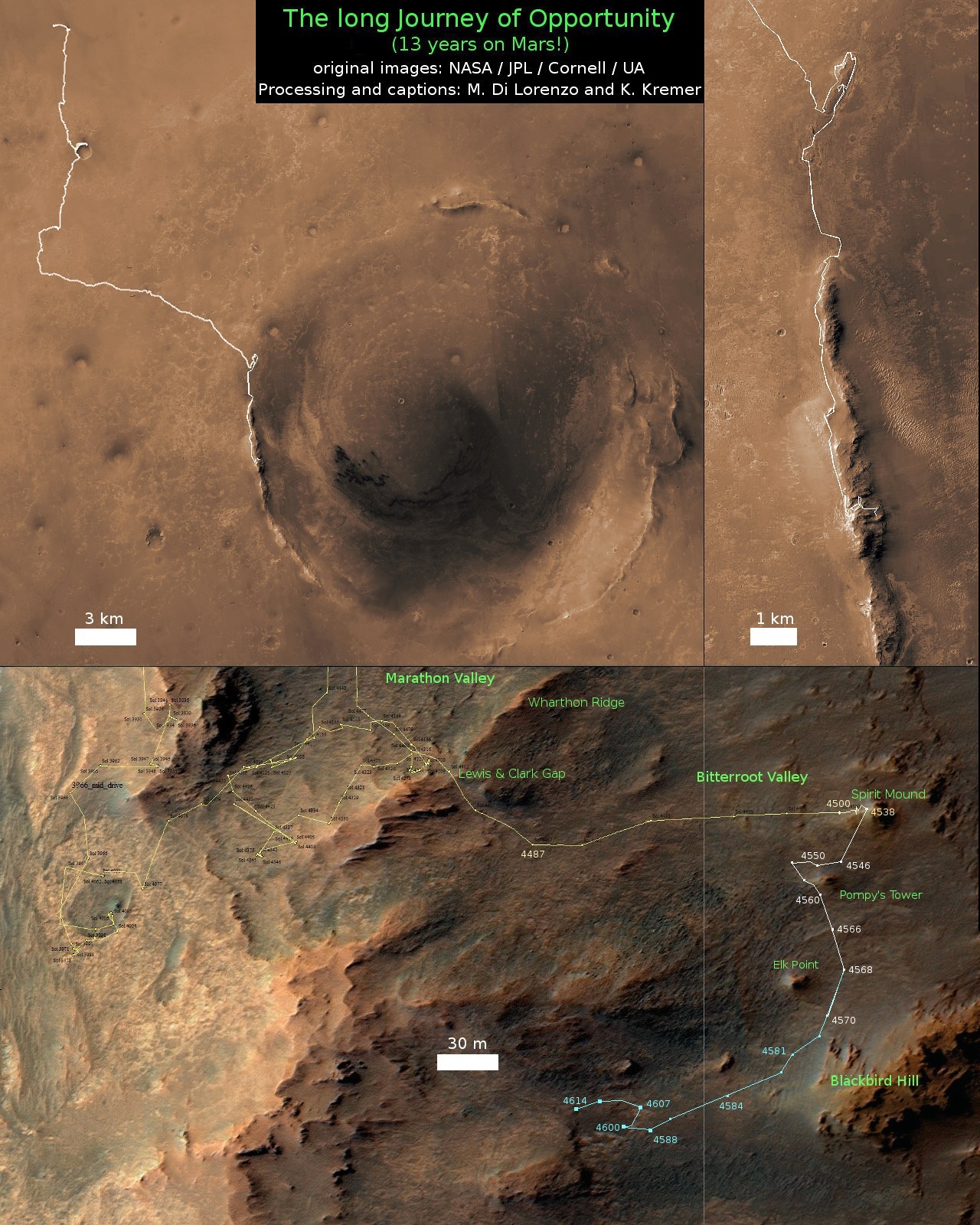
13 Year Traverse Map for NASA’s Opportunity rover from 2004 to 2017. This map shows the entire 43 kilometer (27 mi) path the rover has driven on the Red Planet during over 13 years and more than a marathon runners distance for over 4782 Sols, or Martian days, since landing inside Eagle Crater on Jan 24, 2004 – to current location at the western rim of Endeavour Crater. After studying Spirit Mound and ascending back uphill the rover has reached her next destination in May 2017- the Martian water carved gully at Perseverance Valley near Orion crater. Rover surpassed Marathon distance on Sol 3968 after reaching 11th Martian anniversary on Sol 3911. Opportunity discovered clay minerals at Esperance – indicative of a habitable zone – and searched for more at Marathon Valley. Credit: NASA/JPL/Cornell/ASU/Marco Di Lorenzo/Ken Kremer/kenkremer.com
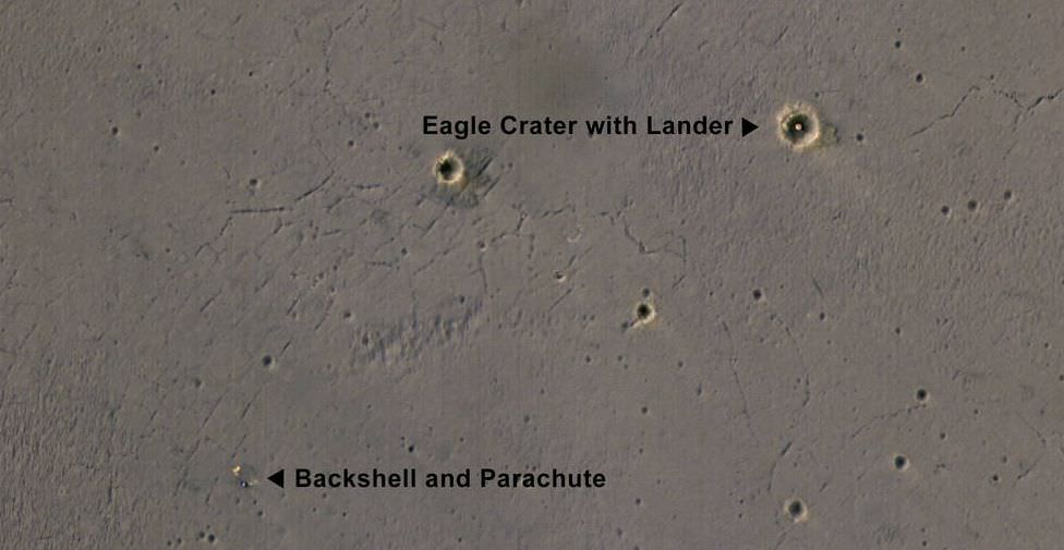
This image taken by the Mars Reconnaissance Orbiter's HiRise camera shows the bright landing platform left behind by NASA's Mars Exploration Rover Opportunity when it landed in 2004. Opportunity landed on the surface of Mars and then bounced and tumbled into the Eagle Crater. The image was taken on April 8, 2017. Image: NASA/JPL-Caltech/Univ. of Arizona
NASA’s eagle-eyed Mars Reconnaissance Orbiter (MRO) has captured orbital images of Opportunity’s Hole-In-One landing site, smack dab in the middle of Eagle Crater on the surface of Mars.
Opportunity arrived at Mars on January 25th, 2005. It’s landing was slowed by parachute, and cushioned by airbags. Once it hit the surface, it bounced its way into “Eagle Crater“, a feature a mere 22 meters across. Not a bad shot!
This is the first color image that the High Resolution Imaging Science Experiment (HiRise) has captured of Opportunity’s landing site. It shows the remarkable landing site inside the crater, where the landing pad was left behind after Opportunity rolled off of it and got going. It also shows the rover’s parachute and backshell.
It’s amazing that, given the relatively smooth surface in Opportunity’s landing area, the rover came to rest inside a small crater. When Opportunity “woke up” at its landing site, its first images were of the inside of Eagle Crater. This was the first look we ever got at the sedimentary rocks on Mars, taken by the rover’s navigation camera.
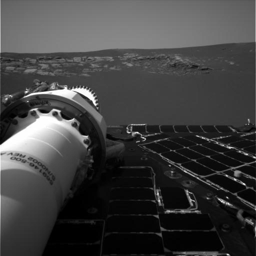
Opportunity’s navigation camera took this picture, one of the rover’s first, of the inside of Eagle Crater. Exposed Martian rocks are visible. NASA/JPL
After leaving Eagle Crater, Opportunity took a look back and captured a panoramic image. Plainly visible is the rover’s landing pad, the exposed sedimentary rock, and the rover’s tracks in the Martian soil.
This panorama image, called “Lion King” was assembled from 558 images totalling over 75 megabytes. The rock outcrop, the landing pad, and the rover’s tracks are all clearly visible. Image: NASA/JPL/Cornell
MRO arrived at Mars a couple years later, and by that time Opportunity had already left its landing site and made its way south to the much larger Victoria Crater.
When the Mars Reconnaissance Orbiter arrived at Mars, 2 years after Opportunity touched down there, Opportunity had left Eagle Crater and travelled the 6 km to Victoria Crater. By NASA/JPL/University of Arizona – http://photojournal.jpl.nasa.gov/catalog/PIA08813, Public Domain, https://commons.wikimedia.org/w/index.php?curid=4211043
Opportunity is still chugging along, doing valuable work. And so is the MRO and its HiRise instrument. At this point, Opportunity has to be considered one of the most successful scientific undertakings ever.
Opportunity took this panorama shot of "Rocheport Ridge" as it left Cape Tribulation. Rocheport is on the southern end of Cape Tribulation. Image:NASA/JPL-Caltech/Cornell Univ./Arizona State Univ.
You’d have to be an intrepid explorer to investigate something named ‘Cape Tribulation’. Opportunity, NASA’s long-lived rover on Mars’ surface, has been just that. But Opportunity is now leaving Cape Tribulation behind, after being in that area since late 2014, or for about 30 months.
Cape Tribulation is the name given to a segment of crater rim at Endeavour Crater, where Opportunity has been for over 5 1/2 years. During that time, Opportunity reached some important milestones. While there, it surpassed 26 miles in distance travelled, the length of a marathon race. It also reached its highest elevation yet, and in ‘Marathon Valley’, it investigated clay outcrops seen from orbit. Opportunity also had some struggles there, when its flash memory stopped working, meaning all data had to be transmitted every day, or lost.
Sol 3906, January 19, 2015. Summit panorama from Cape Tribulation from the Opportunity Mars Rover. Credit: NASA/Arizona State University.
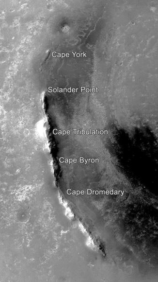
Before reaching Cape Tribulation 30 months ago, Opportunity investigated other parts of Endeavour Crater called “Cape York,” “Solander Point” and “Murray Ridge.”
Some of the named features at Endeavour Crater. Image: NASA/JPL-Caltech/MSSS
The rover’s next destination is Perseverance Valley, where it will investigate how it was carved out billions of years ago: by water, by wind, or perhaps flowing material lubricated by water. Before leaving Cape Tribulation, Opportunity captured the panoramic image of Rochefort Ridge, a section of the Endeavour Crater rim marked by grooves on its side.”The degree of erosion at Rocheport is fascinating,” said Opportunity Deputy Principal Investigator Ray Arvidson, of Washington University in St. Louis. “Grooves run perpendicular to the crest line. They may have been carved by water or ice or wind. We want to see as many features like this on the way to Perseverance Valley as we can, for comparison with what we find there.”
Endeavour crater is about 22km in diameter, and Perseverance Valley is about 2 football fields long. The goal at Endeavour is to investigate its segmented rim, where the oldest rocks ever investigated on Mars are exposed. Since the beginning of April, Opportunity has travelled about 98 meters, to a point where Cape Tribulation meets the plain around the crater.
“From the Cape Tribulation departure point, we’ll make a beeline to the head of Perseverance Valley…” – Opportunity Deputy Principal Investigator Ray Arvidson
“From the Cape Tribulation departure point, we’ll make a beeline to the head of Perseverance Valley, then turn left and drive down the full length of the valley, if we can,” Arvidson said. “It’s what you would do if you were an astronaut arriving at a feature like this: Start at the top, looking at the source material, then proceed down the valley, looking at deposits along the way and at the bottom.”
It’s the nature of those deposits that can give vital clues to how Perseverance Valley was formed. Arvidson said, “If it was a debris flow, initiated by a little water, with lots of rocks moving downhill, it should be a jumbled mess. If it was a river cutting a channel, we may see gravel bars, crossbedding, and what’s called a ‘fining upward’ pattern of sediments, with coarsest rocks at the bottom.”
Opportunity, and its sister rover Spirit, arrived at Mars in 2004, with a planned mission length of 90 days. Opportunity has surpassed that by over 12 years, and continues to perform extremely well in the Martian environment.
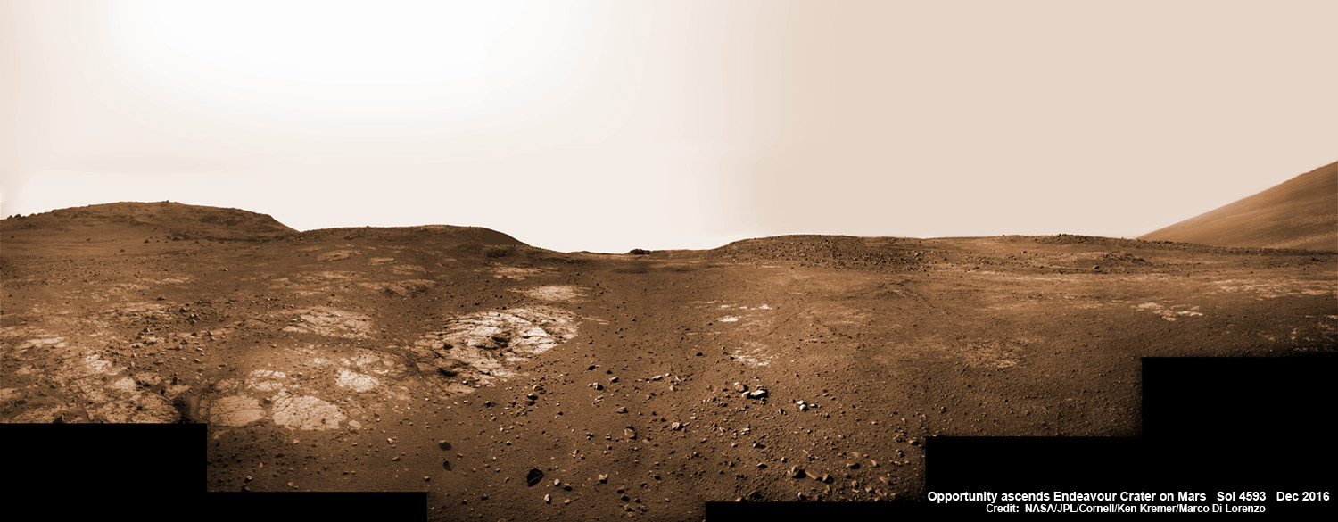
13 Years on Mars! On Christmas Day 2016, NASA’s Opportunity rover scans around vast Endeavour crater as she ascends steep rocky slopes on the way to reach a water carved gully along the eroded craters western rim. This navcam camera photo mosaic was assembled from raw images taken on Sol 4593 (25 Dec. 2016) and colorized. Credit: NASA/JPL/Cornell/Ken Kremer/kenkremer.com/Marco Di Lorenzo
13 Years on Mars!
On Christmas Day 2016, NASA’s Opportunity rover scans around vast Endeavour crater as she ascends steep rocky slopes on the way to reach a water carved gully along the eroded craters western rim. This navcam camera photo mosaic was assembled from raw images taken on Sol 4593 (25 Dec. 2016) and colorized. Credit: NASA/JPL/Cornell/Ken Kremer/kenkremer.com/Marco Di Lorenzo
NASA’s truly outstanding Opportunity rover continues “making new discoveries about ancient Mars” as she commemorates 13 Years since bouncing to a touchdown on Mars, in a feat that is “truly amazing” – the deputy chief scientist Ray Arvidson told Universe Today exclusively.
“Reaching the 13th year anniversary with a functioning rover making new discoveries about ancient Mars on a continuing basis is truly amazing,” Ray Arvidson, Opportunity Deputy Principal Investigator of Washington University in St. Louis, told Universe Today.
Put another way Opportunity is 13 YEARS into her 3 MONTH mission! And still going strong!
During the past year the world famous rover discovered “more extensive aqueous alteration within fractures and more mild alteration within the bedrock outcrops” at Endeavour crater, Arvidson elaborated.
And now she is headed to her next target – an ancient water carved gully!
The gully is situated about 0. 6 mile (1.6 km) south of the robots current location.
But to get there she first has to heroically ascend steep rocky slopes inclined over 20 degrees along the eroded craters western rim – and it’s no easy task! Slipping and sliding along the way and all alone on difficult alien terrain.
Furthermore she is 51 times beyond her “warrantied” life expectancy of merely 90 Sols promised at the time of landing so long ago – roving the surface of the 4th rock from the Sun during her latest extended mission; EM #10.
How was this incredible accomplishment achieved?
“Simply a well-made and thoroughly tested American vehicle,” Arvidson responded.
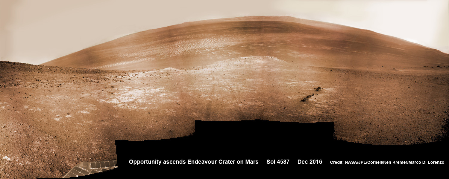
NASA’s Opportunity rover scans around and across to vast Endeavour crater on Dec. 19, 2016, as she climbs steep slopes on the way to reach a water carved gully along the eroded craters western rim. Note rover wheel tracks at center. This navcam camera photo mosaic was assembled from raw images taken on Sol 4587 (19 Dec. 2016) and colorized. Credit: NASA/JPL/Cornell/Ken Kremer/kenkremer.com/Marco Di Lorenzo
The six wheeled rover landed on Mars on January 24, 2004 PST on the alien Martian plains at Meridiani Planum -as the second half of a stupendous sister act.
Her twin sister Spirit, had successfully touched down 3 weeks earlier on January 3, 2004 inside 100-mile-wide Gusev crater and survived more than six years.
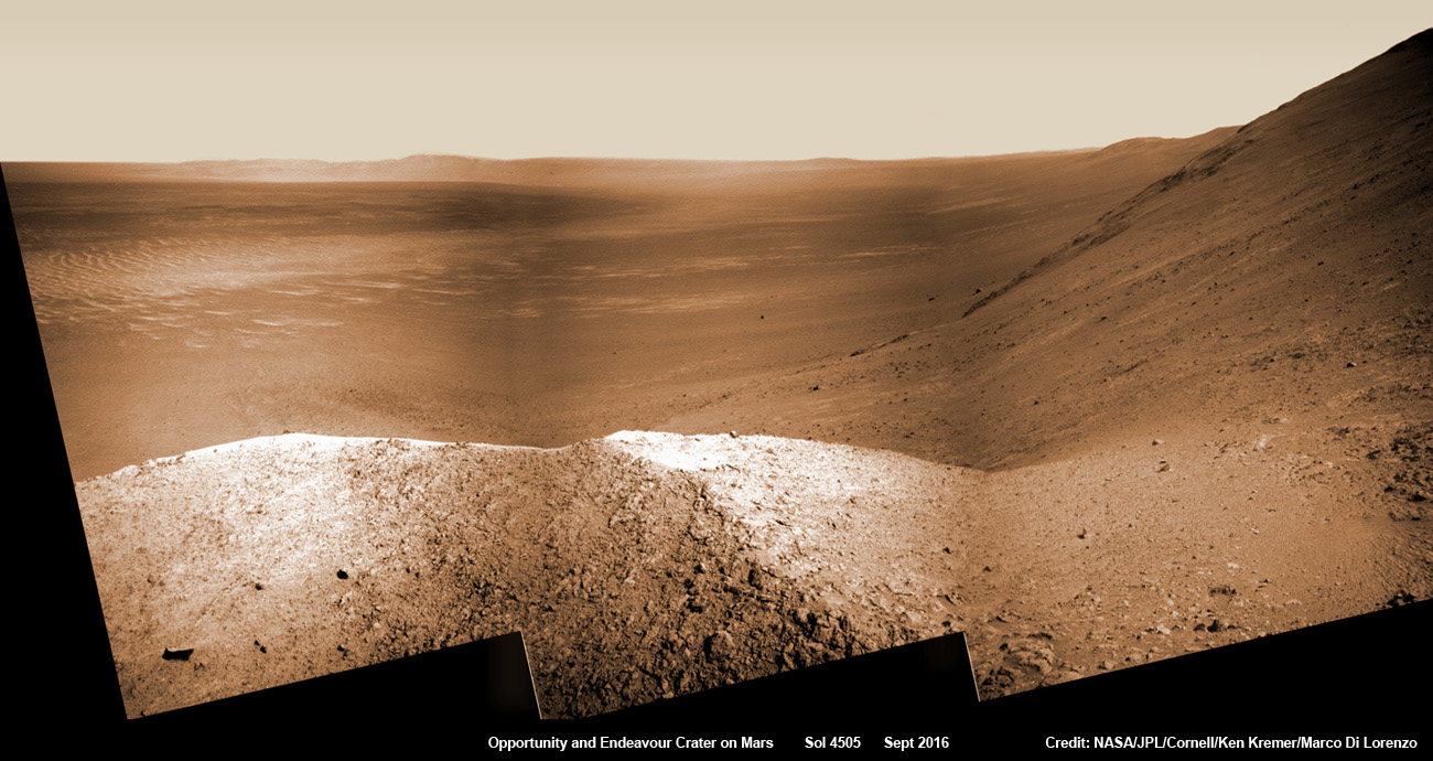
NASA’s Opportunity explores Spirit Mound after descending down Marathon Valley and looks out across the floor of vast Endeavour crater. This navcam camera photo mosaic was assembled from raw images taken on Sol 4505 (25 Sept 2016) and colorized. Credit: NASA/JPL/Cornell/ Ken Kremer/kenkremer.com/Marco Di Lorenzo
Opportunity concluded 2016 and starts 2017 marching relentlessly towards an ancient water carved gully along the eroded rim of vast Endeavour crater – the next science target on her heroic journey traversing across never before seen Red Planet terrains.
Huge Endeavour crater spans some 22 kilometers (14 miles) in diameter.
Throughout 2016 Opportunity was investigating the ancient, weathered slopes around the Marathon Valley location in Endeavour crater. The area became a top priority science destination after the slopes were found to hold a motherlode of ‘smectite’ clay minerals based on data from the CRISM spectrometer circling overhead aboard a NASA Mars orbiter.
The smectites were discovered via extensive, specially targeted Mars orbital measurements gathered by the CRISM (Compact Reconnaissance Imaging Spectrometer for Mars) spectrometer on NASA’s Mars Reconnaissance Orbiter (MRO) – accomplished earlier at the direction of Arvidson.
Opportunity was descending down Marathon Valley the past year to investigate the clay minerals formed in water. They are key to helping determine the habitability of the Red Planet when it was warmer and wetter billions of years ago.
What did Opportunity accomplish scientifically at Marathon Valley during 2016?
“Key here is the more extensive aqueous alteration within fractures and more mild alteration within the bedrock outcrops,” Arvidson explained to me.
“Fractures have red pebbles enhanced in Al and Si (likely by leaching out more soluble elements), hematite, and in the case of our scuffed fracture, enhanced sulfate content with likely Mg sulfates and other phases. Also the bedrock is enriched in Mg and S relative to other Shoemaker rocks and these rocks are the smectite carrier as observed from CRISM ATO data.”
Marathon Valley measures about 300 yards or meters long. It cuts downhill through the west rim of Endeavour crater from west to east – the same direction in which Opportunity drove downhill from a mountain summit area atop the crater rim.
Opportunity has been exploring Endeavour since arriving at the humongous crater in 2011. Endeavour crater was formed when it was carved out of the Red Planet by a huge meteor impact billions of years ago.
“Endeavour crater dates from the earliest Martian geologic history, a time when water was abundant and erosion was relatively rapid and somewhat Earth-like,” explains Larry Crumpler, a science team member from the New Mexico Museum of Natural History & Science.
Opportunity has been climbing up very steep and challenging slopes to reach the top of the crater rim. Then she will drive south to Cape Byron and the gully system.
“We have had some mobility issues climbing steep, rocky slopes. Lots of slipping and skidding, but evaluating the performance of the rover on steep, rocky and soil-covered slopes was one of the approved extended mission objectives,” Arvidson explained.
“We are heading out of Cape Tribulation, driving uphill to the southwest to reach the Meridiani plains and then to drive to the western side of Cape Byron to the head of a gully system.”
What’s ahead for 2017? What’s the importance of exploring the gully?
“Finish up work on Cape Tribulation, traverse to the head of the gully system and head downhill into one or more of the gullies to characterize the morphology and search for evidence of deposits,” Arvidson elaborated.
“Hopefully test among dry mass movements, debris flow, and fluvial processes for gully formation. The importance is that this will be the first time we will acquire ground truth on a gully system that just might be formed by fluvial processes. Will search for cross bedding, gravel beds, fining or coarsening upward sequences, etc., to test among hypotheses.”
How long will it take to reach the gully?
“Months to the gully,” replied Arvidson. After arriving at the top of the crater rim, the rover will actually drive part of the way on the Martian plains again during the southward trek to the gully.
“And we will be driving on the plains to drive relatively long distances with an intent of getting to the gully well before the winter season.”
As of today, Jan 31, 2017, long lived Opportunity has survived 4630 Sols (or Martian days) roving the harsh environment of the Red Planet.
Opportunity has taken over 216,700 images and traversed over 27.26 miles (43.87 kilometers) – more than a marathon.
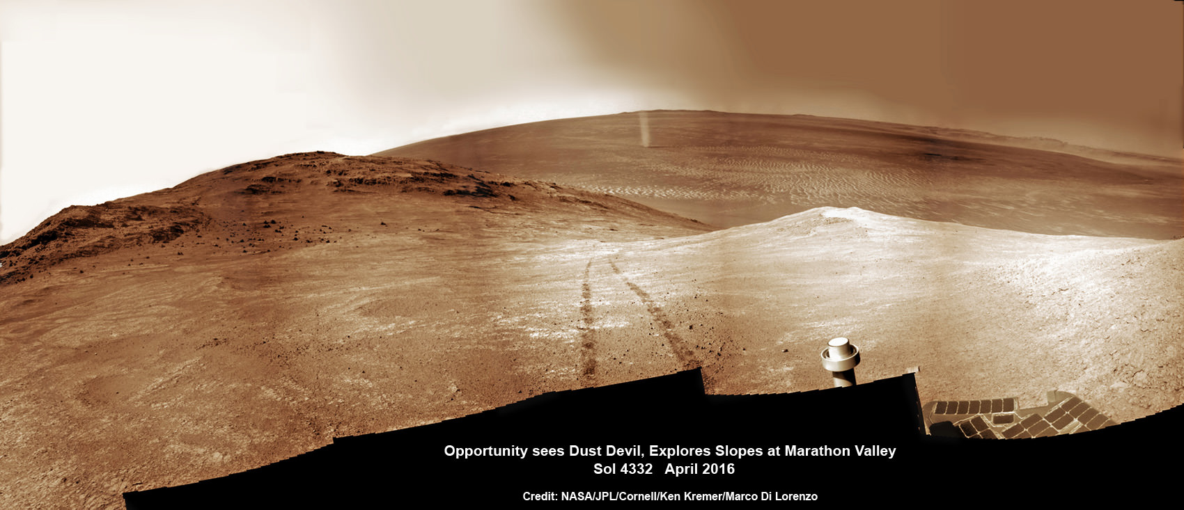
NASA’s Opportunity rover discovers a beautiful Martian dust devil moving across the floor of Endeavour crater as wheel tracks show robots path today exploring the steepest ever slopes of the 13 year long mission, in search of water altered minerals at Knudsen Ridge inside Marathon Valley on 1 April 2016. This navcam camera photo mosaic was assembled from raw images taken on Sol 4332 (1 April 2016) and colorized. Credit: NASA/JPL/Cornell/ Ken Kremer/kenkremer.com/Marco Di Lorenzo
See our updated route map below. It shows the context of the rovers over 13 year long traverse spanning more than the 26 mile distance of a Marathon runners race.
The rover surpassed the 27 mile mark milestone on November 6, 2016 (Sol 4546).
The power output from solar array energy production is currently 416 watt-hours, before heading into another southern hemisphere Martian winter in 2017. It will count as Opportunities 8th winter on Mars.
Meanwhile Opportunity’s younger sister rover Curiosity traverses and drills into the lower sedimentary layers at the base of Mount Sharp.
Stay tuned here for Ken’s continuing Earth and planetary science and human spaceflight news.
13 Year Traverse Map for NASA’s Opportunity rover from 2004 to 2017. This map shows the entire 43 kilometer (27 mi) path the rover has driven on the Red Planet during more than 13 years and more than a marathon runners distance for over 4614 Sols, or Martian days, since landing inside Eagle Crater on Jan 24, 2004 – to current location at the western rim of Endeavour Crater. After descending down Marathon Valley and after studying Spirit Mound, the rover is now ascending back uphill on the way to a Martian water carved gully. Rover surpassed Marathon distance on Sol 3968 after reaching 11th Martian anniversary on Sol 3911. Opportunity discovered clay minerals at Esperance – indicative of a habitable zone – and searched for more at Marathon Valley. Credit: NASA/JPL/Cornell/ASU/Marco Di Lorenzo/Ken Kremer/kenkremer.com
NASA’s Opportunity rover discovers a beautiful Martian dust devil moving across the floor of Endeavour crater as wheel tracks show robots path today exploring the steepest ever slopes of the 13 year long mission, in search of water altered minerals at Knudsen Ridge inside Marathon Valley on 1 April 2016. This navcam camera photo mosaic was assembled from raw images taken on Sol 4332 (1 April 2016) and colorized. Credit: NASA/JPL/Cornell/ Ken Kremer/kenkremer.com/Marco Di Lorenzo
NASA’s Opportunity rover discovers a beautiful Martian dust devil moving across the floor of Endeavour crater as wheel tracks show robots path today exploring the steepest ever slopes of the 13 year long mission, in search of water altered minerals at Knudsen Ridge inside Marathon Valley on 1 April 2016. This navcam camera photo mosaic was assembled from raw images taken on Sol 4332 (1 April 2016) and colorized. Credit: NASA/JPL/Cornell/ Ken Kremer/kenkremer.com/Marco Di Lorenzo
A “beautiful dust devil” was just discovered today, April 1, on the Red Planet by NASA’s long lived Opportunity rover as she is simultaneously exploring water altered rock outcrops at the steepest slopes ever targeted during her 13 year long expedition across the Martian surface. Opportunity is searching for minerals formed in ancient flows of water that will provide critical insight into establishing whether life ever existed on the fourth rock from the sun.
“Yes a beautiful dust devil on the floor of Endeavour Crater,” Ray Arvidson, Opportunity Deputy Principal Investigator of Washington University in St. Louis, confirmed to Universe Today. Spied from where “Opportunity is located on the southwest part of Knudsen Ridge” in Marathon Valley.
The new dust devil – a mini tornado like feature – is seen scooting across the ever fascinating Martian landscape in our new photo mosaic illustrating the steep walled terrain inside Marathon Valley and overlooking the crater floor as Opportunity makes wheel tracks at the current worksite on a crest at Knudsen Ridge. The colorized navcam camera mosaic combines raw images taken today on Sol 4332 (1 April 2016) and stitched by the imaging team of Ken Kremer and Marco Di Lorenzo.
“The dust devils have been kind to this rover,” Jim Green, Director of NASA Planetary Sciences at NASA HQ, said in an exclusive interview with Universe Today. They are associated with prior periods of solar array cleansing power boosts that contributed decisively to her longevity.
“Oppy’s best friend is on its way!”
Spotting dust devils has been relatively rare for Opportunity since landing on Mars on Jan. 24, 2004.
“There are 7 candidates, 6 of which are likely or certain,” Mark Lemmon, rover science team member from Texas A & M University, told Universe Today. “Most were seen in, on the rim of, or adjacent to Endeavour.”
Starting in late January, scientists commanded the golf cart sized Opportunity to drive up the steepest slopes ever attempted by any Mars rover in order to reach rock outcrops where she can conduct breakthrough science investigations on smectite (phyllosilicate) clay mineral bearing rocks yielding clues to Mars watery past.
“We are beginning an imaging and contact science campaign in an area where CRISM spectra show evidence for deep absorptions associated with Fe [Iron], Mg [Magnesium] smectites,” Arvidson explained.
A shadow and tracks of NASA’s Mars rover Opportunity appear in this March 22, 2016, image, which has been rotated 13.5 degrees to adjust for the tilt of the rover. The hillside descends to the left into “Marathon Valley.” The floor of Endeavour Crater is seen beneath the underside of a solar panel. Credits: NASA/JPL-Caltech
This is especially exciting to researchers because the phyllosilicate clay mineral rocks formed under water wet, non-acidic conditions that are more conducive to the formation of Martian life forms – billions of years ago when the planet was far warmer and wetter.
“We have been in the smectite [phyllosilicate clay mineral] zone for months, ever since we entered Marathon Valley.”
The smectites were discovered via extensive, specially targeted Mars orbital measurements gathered by the CRISM (Compact Reconnaissance Imaging Spectrometer for Mars) spectrometer on NASA’s Mars Reconnaissance Orbiter (MRO) – accomplished earlier at the direction of Arvidson.
So the ancient, weathered slopes around Marathon Valley became a top priority science destination after they were found to hold a motherlode of ‘smectite’ clay minerals based on the CRISM data.
“Marathon Valley is unlike anything we have ever seen. Looks like a mining zone!”
At this moment, the rover is driving to an alternative rock outcrop located on the southwest area of the Knudsen Ridge hilltops after trying three times to get within reach of the clay minerals by extending her instrument laden robotic arm.
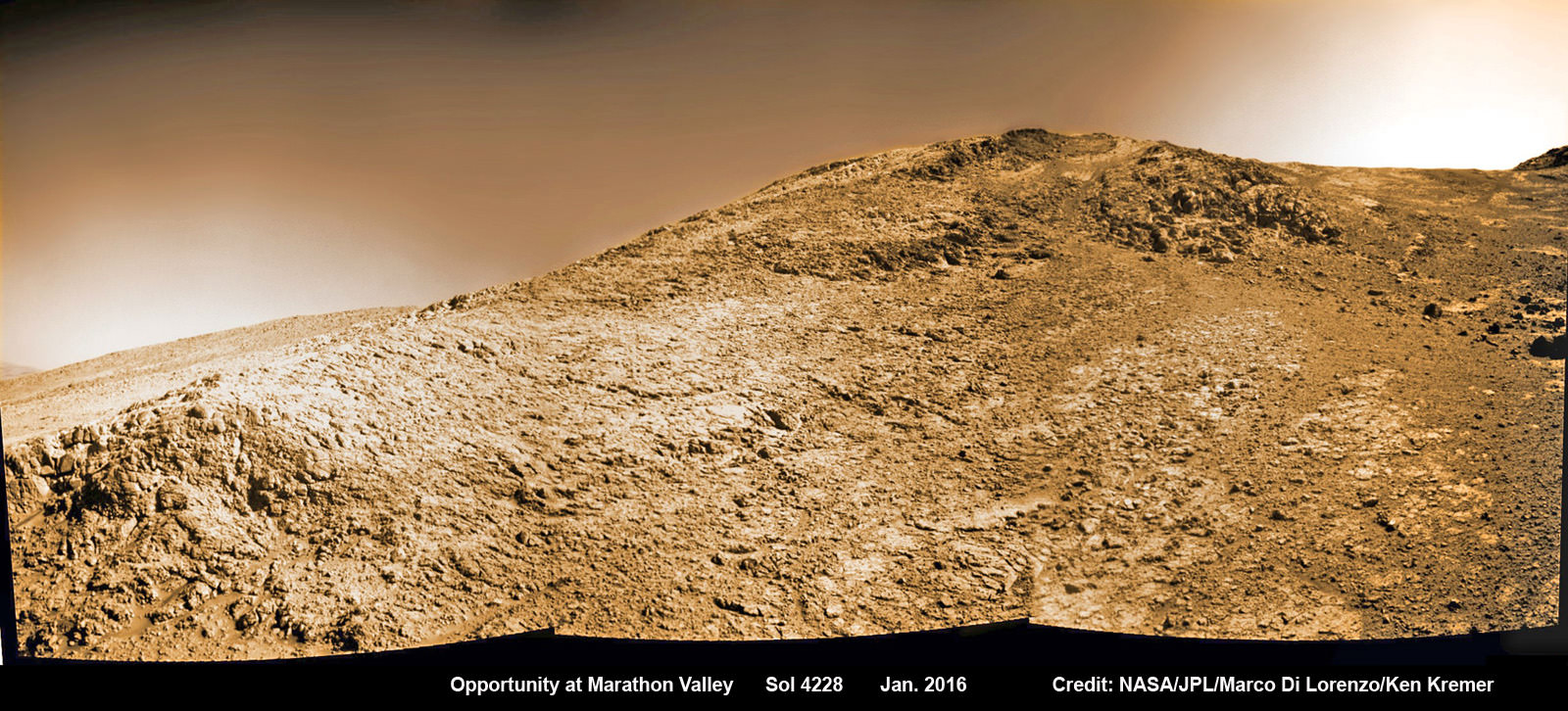
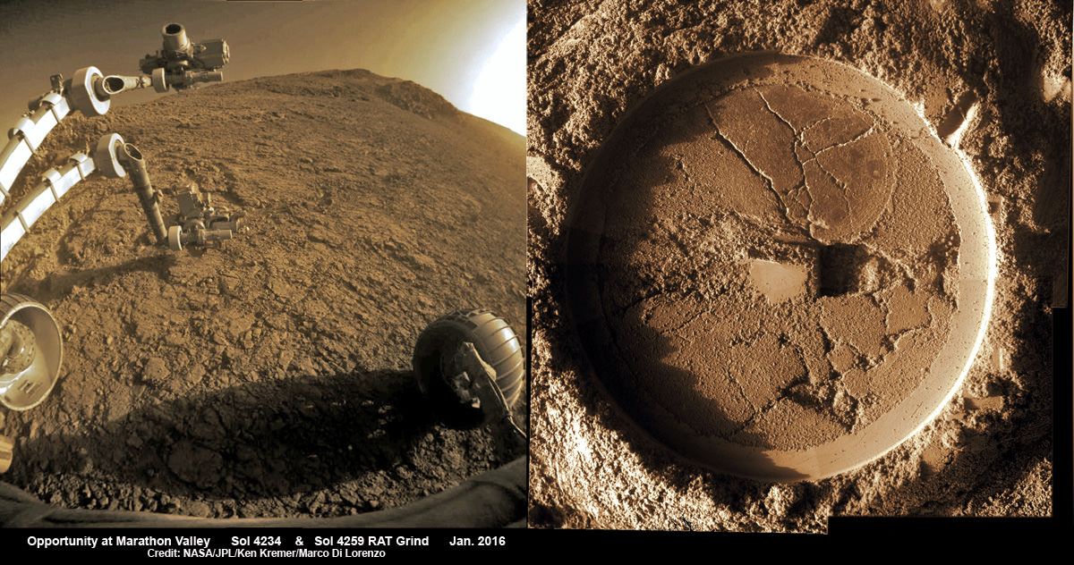
NASA’s Opportunity rover images current worksite at Knudsen Ridge on Sol 4228 where the robot is grinding into rock targets inside Marathon Valley during 12th Anniversary of touchdown on Mars in Jan. 2016. Credit: NASA/JPL/Cornell/Marco Di Lorenzo/Ken Kremer/kenkremer.com
Unfortunately, but not unexpectedly, the rover kept slipping on the steep walled slopes – tilted as much as 32 degrees – while repeatedly attempting close approaches to the intended target. Ultimately she came within 3 inches of the surface science target ‘Pvt. Joseph Whitehouse’ – named after a member of the Corps of Discovery.
In fact despite rotating her wheels enough to push uphill about 66 feet (20 meters) if there had been no slippage, engineers discerned from telemetry that slippage was so great that “the vehicle progressed only about 3.5 inches (9 centimeters). This was the third attempt to reach the target and came up a few inches short,” said NASA.
“The rover team reached a tough decision to skip that target and move on.”
So they backed Opportunity downhill about 27 feet (8.2 meters), then drove about 200 feet (about 60 meters) generally southwestward and uphill, toward the next target area.
NASA officials noted that “the previous record for the steepest slope ever driven by any Mars rover was accomplished while Opportunity was approaching “Burns Cliff” about nine months after the mission’s January 2004 landing on Mars.”
Marathon Valley measures about 300 yards or meters long. It cuts downhill through the west rim of Endeavour crater from west to east – the same direction in which Opportunity is currently driving downhill from a mountain summit area atop the crater rim. See our route map below showing the context of the rovers over dozen year long traverse spanning more than the 26 mile distance of a Marathon runners race.
Endeavour crater spans some 22 kilometers (14 miles) in diameter. Opportunity has been exploring Endeavour since arriving at the humongous crater in 2011.
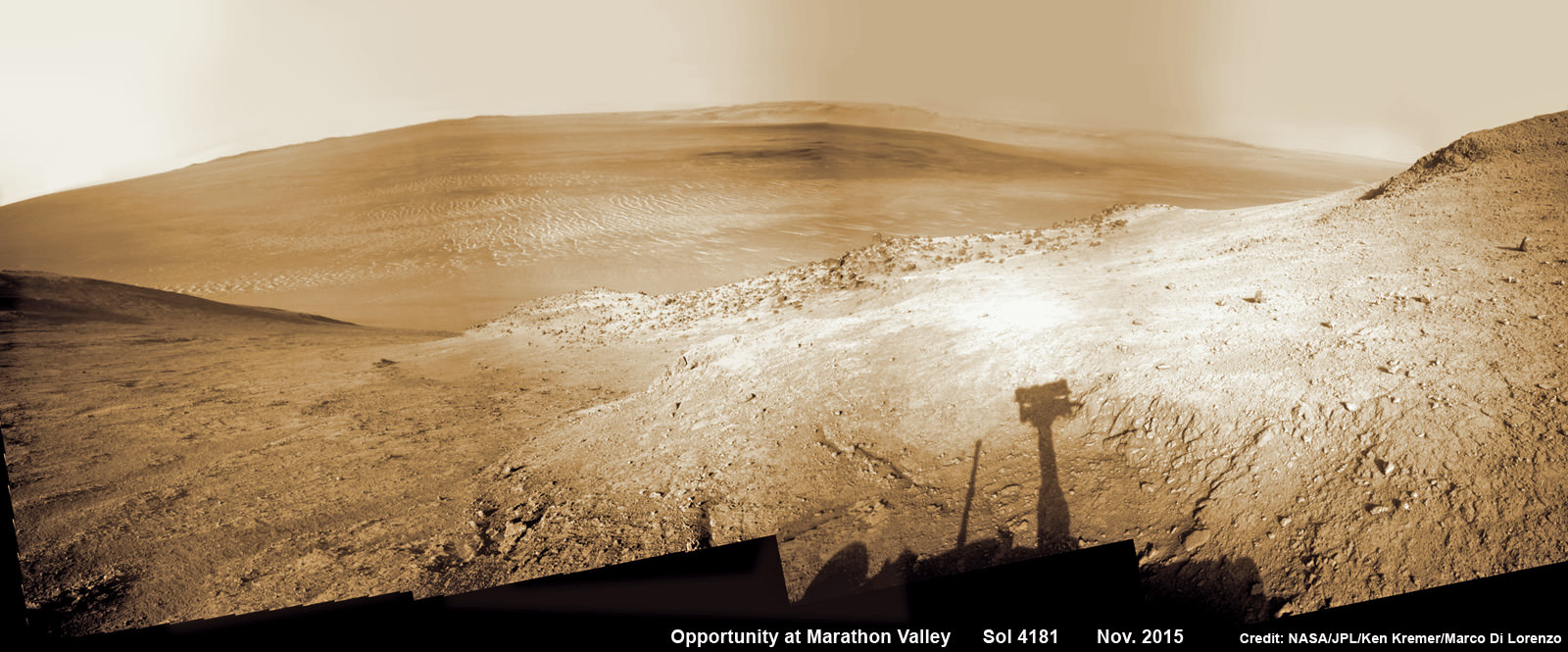
NASA’s Opportunity rover peers outwards across to the vast expense of Endeavour Crater from current location descending along steep walled Marathon Valley in early November 2015. Marathon Valley holds significant deposits of water altered clay minerals holding clues to the planets watery past. Shadow of Pancam Mast assembly and robots deck visible at right. This navcam camera photo mosaic was assembled from images taken on Sol 4181 (Oct. 29, 2015) and colorized. Credit: NASA/JPL/Cornell/Ken Kremer/kenkremer.com/Marco Di Lorenzo
Why are the dust devils a big deal?
Offering more than just a pretty view, the dust devils actually have been associated with springtime Martian winds that clear away the dust obscuring the robots life giving solar panels.
“Opportunity is largely in winter mode sitting on a hill side getting maximum power. But it is in a better power status than in many past winters,” Jim Green, Director of NASA Planetary Sciences at NASA HQ, told Universe Today exclusively.
“I think I know the reason. As one looks across the vistas of Mars in this mosaic Oppys best friend is on its way.”
“The dust devils have been kind to this rover. Even I have a smile on my face when I see what’s coming.”
12 Year Traverse Map for NASA’s Opportunity rover from 2004 to 2016. This map shows the entire path the rover has driven during almost 12 years and more than a marathon runners distance on Mars for over 4332 Sols, or Martian days, since landing inside Eagle Crater on Jan 24, 2004 – to current location at the western rim of Endeavour Crater and descending into Marathon Valley. Rover surpassed Marathon distance on Sol 3968 and marked 11th Martian anniversary on Sol 3911. Opportunity discovered clay minerals at Esperance – indicative of a habitable zone – and is currently searching for more at Marathon Valley. Credit: NASA/JPL/Cornell/ASU/Marco Di Lorenzo/Ken Kremer/kenkremer.com
As of today, Sol 4332, Apr. 1, 2016, Opportunity has taken over 209,200 images and traversed over 26.53 miles (42.69 kilometers) – more than a marathon.
The power output from solar array energy production has climbed to 576 watt-hours, now just past the depths of southern hemisphere Martian winter.
Meanwhile Opportunity’s younger sister rover Curiosity traverses and drills into the basal layers at the base of Mount Sharp.
This March 21, 2016, image from the navigation camera on NASA’s Mars rover Opportunity shows streaks of dust or sand on the vehicle’s rear solar panel after a series of drives during which the rover was pointed steeply uphill. The tilt and jostling of the drives affected material on the rover deck. Credits: NASA/JPL-Caltech
Stay tuned here for Ken’s continuing Earth and planetary science and human spaceflight news.
Learn more about NASA Mars rovers, Orion, SLS, ISS, Orbital ATK, ULA, SpaceX, Boeing, Space Taxis, NASA missions and more at Ken’s upcoming outreach events:
Apr 9/10: “NASA and the Road to Mars Human Spaceflight programs” and “Curiosity explores Mars” at NEAF (NorthEast Astronomy and Space Forum), 9 AM to 5 PM, Suffern, NY, Rockland Community College and Rockland Astronomy Club – http://rocklandastronomy.com/neaf.html
Apr 12: Hosting Dr. Jim Green, NASA, Director Planetary Science, for a Planetary sciences talk about “Ceres, Pluto and Planet X” at Princeton University; 7:30 PM, Amateur Astronomers Assoc of Princeton, Peyton Hall, Princeton, NJ – http://www.princetonastronomy.org/
Apr 17: “NASA and the Road to Mars Human Spaceflight programs”- 1:30 PM at Washington Crossing State Park, Nature Center, Titusville, NJ – http://www.state.nj.us/dep/parksandforests/parks/washcros.html
A shadow and tracks of NASA’s Mars rover Opportunity appear in this March 22, 2016, colorized hazcam camera image, which has been rotated 13.5 degrees to adjust for the tilt of the rover. The hillside descends to the left into “Marathon Valley.” The floor of Endeavour Crater is seen beneath the underside of a solar panel. Credits: NASA/JPL-Caltech/Marco Di Lorenzo/Ken Kremer/kenkremer.com
Composite hazcam camera image (left) shows the robotic arm in motion as NASA’s Mars Exploration Rover Opportunity places the tool turret on the target named “Private John Potts” on Sol 4234 to brush away obscuring dust. Rover is actively working on the southern side of “Marathon Valley” which slices through western rim of Endeavour Crater. On Sol 4259 (Jan. 16, 2016), Opportunity completed grinds with the Rock Abrasion Tool (RAT) to exposure rock interior for elemental analysis, as seen in mosaic (right) of four up close images taken by Microscopic Imager (MI). Credit: NASA/JPL/Cornell/Ken Kremer/kenkremer.com/Marco Di Lorenzo