The
*Mars Express*
probe was the European Space Agency's first attempt to explore Mars. Since its arrival around the Red Planet in 2003, the probe has helped determine the composition of the atmosphere, map the mineral composition of the surface, studied the interaction between the atmosphere and solar wind, and taken many high-resolution images of the surface.
And even after 14 years of continuous operation, it is still revealing interesting things about Mars and its past. The latest find comes from the Kasei Valles region, where the probe captured new images of the giant system of canyons. As one of the largest outflow channel networks on the Red Planet, this region is evidence of a massive flood having taken place billions of years ago.
This region formed between 3.6 and 3.4 billion years ago, when a combination of volcanic and tectonic activity in the Tharsis region triggered groundwater releases from Echus Chasma. This chasm, located in the Lunae Planum plateau, contains clay deposits that indicate the presence of liquid water at one time. This water then flooded through Kasei Valles, emptying into the Chryse Planitia region and leaving behind signs of water erosion.
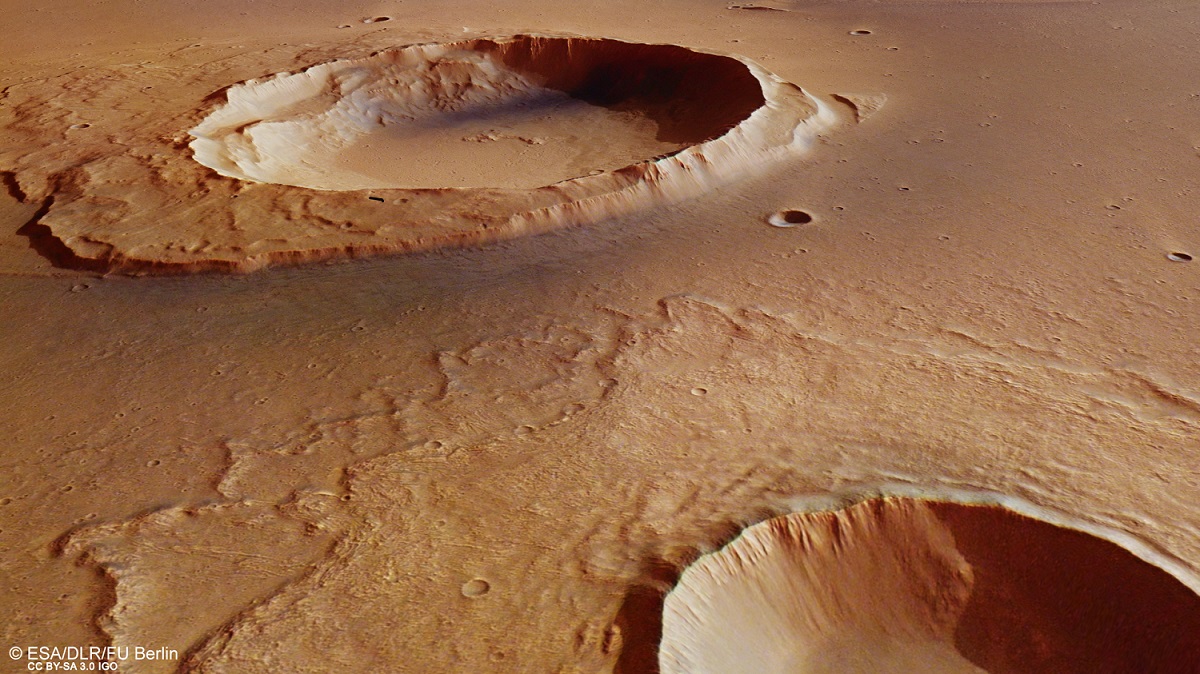
[caption id="attachment_134147" align="aligncenter" width="580"]
Colour-coded topographic view of the mouth of Kasei Valles, showing the Worcester Crater. Credit: ESA/DLR/FU Berlin.
[/caption]
The Mars Express probe has captured images of this region before. But these latest images, which were snapped n May 25th, 2016, captured the topography of an area that lies at the mouth of the system. Of particular interest was the 25-km-wide Worcester Crater, the remains of an impact that has managed to remain intact despite the erosive force of the mega-flood.
The appearance of this crater and the features around it - which resemble an island - tell us much about the region and its history. For instance, the island has a stepped topography, which is likely the result of its interaction with the flood waters. After the impact threw up material around the crater, moving water pushed it downstream, creating a rigid wall facing towards Kasei Valles and a sloping wall trailing away from it.
The topography of the island is also suggestive of variations in water levels, or possibly different flood episodes. As the water rose and fell, or multiple streams formed over time, the downstream portion of the "island" was affected. There is also the larger crater that appears to the upper right of the image, which sits in a plateau 1 km (0.6 mi) higher than the plains below.
There is a small depression in its center, which would imply that a weaker layer - possibly made of ice - existed under the plateau during the time of impact. This is consistent with the patterns noted in Worcester's debris blanket, which also suggest the area was rich in water or water-ice during the flooding. The presence of small branch-like channels (aka. dendritic channels) around the plateau are another indication that water levels here varied over time.
[caption id="attachment_134148" align="aligncenter" width="580"]
Context image shows a region of Mars where Kasei Valles empties into the vast Chryse Planitia. Credit: NASA/MGS/MOLA Science Team
[/caption]
Many smaller craters are also visible in this photo across the mouth of the Kasei Valles region, which also appear to have "tails" of ejected material. This is also true of the crater that sits adjacent to Worchester, who's debris blanket appears to be largely intact. This would suggest that these craters were formed after the flooding, and any tails that formed were the result of wind.
From all this, it can be concluded that roughly three and a half billion years ago, the mouth of the Kasei Valles region still had water on its surface - possibly still in liquid form but most likely in the form of ice. Volcanic activity - which Mars was still experiencing at the time - then triggered the release of flood waters, which created debris and erosion features throughout the region.
As a result, this latest image manages to capture a preserved record of the geological activity in this region, one which goes back billions of years. And in addition to proving that Mars still had water on its surface, it also confirms that Mars was still experiencing volcanism. It is because of ongoing discoveries like these that the Mars Express mission has been extended several times, the most recent of which extended the mission to end of 2018.
Further Reading: ESA