An Incredible Journey, Mars Curiosity Rover Reaches the Base of Mount Sharp

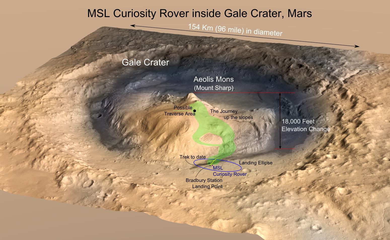
Scientists at the Jet Propulsion Laboratory have announced that the Mars Science Lab (MSL), Curiosity Rover, has reached the base of the central peak inside Gale Crater, Aeolis Mons also known as Mount Sharp. Mount Sharp is a prime objective of NASA’s Curiosity journey. The mountain is like a layer cake, holding a chronology of past events, one after the other, stacked upon each other over billions of years. It took two years and one month to reach this present point and what lies ahead is the beginning of an upward trek towards the peak of Mount Sharp, 5500 meters (18,000 feet) above the floor of Gale Crater. However, it is worth a look back and to consider what Mount Sharp represents to the mission.

For over 17 years, NASA robotic spacecraft have maintained a constant presence above or upon the surface of Mars. The Mars Pathfinder mission arrived on July 4, 1997, then quickly followed by Mars Global Surveyor on September 11 and since this time, there has always been at least one active Mars mission.

"Seven Minutes of Terror" - the Entry, Descent and Landing (EDL) of the Mars Science Lab (MSL) - Mars Curiosity Rover. (Credit: NASA/JPL)
“Seven Minutes of Terror” – the Entry, Descent and Landing (EDL) of the Mars Science Lab (MSL) – Mars Curiosity Rover. (Credit: NASA/JPL)

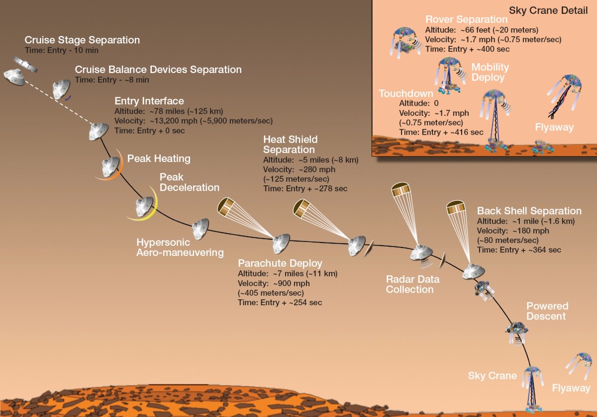
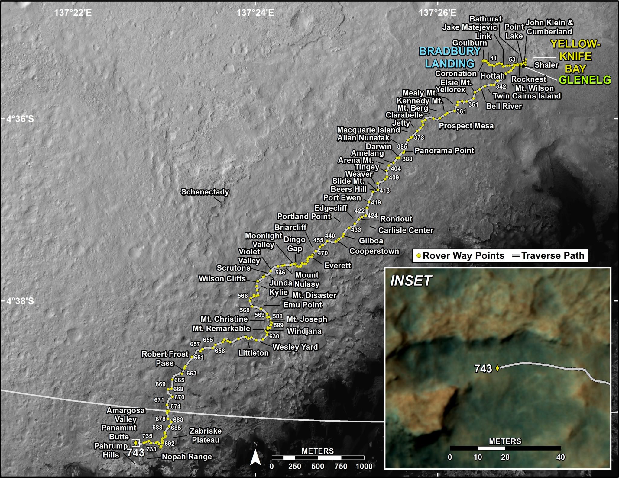
On November 26, 2011, the voyage of Mars Curiosity Rover began as a trek across 320 million kilometers (200 million miles) of the inner Solar System and culminated in the coined “Seven Minutes of Terror”. For seven long minutes, the MSL, the Mars Curiosity Rover, plowed straight into the Martian atmosphere – the entry, deployed a parachute – the descent, to slow down to about 320 km/hour (200 mph) then the Sky Crane with Rover under foot was released – the landing. With only seconds before an imminent hard impact, the Sky Crane hit the breaks, firing its rockets, then released Curiosity Rover on a tether. This was the Entry, Descent and Landing (EDL). All the while, it was the computer inside the Rover in control. When the tether was cut, the Sky Crane was forced to switch to a simpler processor within its system to complete a final scuttling of itself a few hundred meters away.

The Sky Crane gently lowered Curiosity to the landing point, christened Bradbury Station after the celebrated science fiction writer, Ray Bradbury, writer of the Martian Chronicles(c.1950), who passed away at age 91, 61 days before the landing on August 5, 2012. (recommended video – R. Bradbury reading “If Only We had been Taller” at the public event marking the arrival of Mariner 9 at Mars, November 12, 1971)


The ultimate Selfie - a self-protrait taken on anoher planet. This is the capability of the Mars Hand Lens Imager (MAHLI) camera, one of 5 instruments on the turret at the end of the 2.1 meter (7 ft), 30 kg (66 lb) Robotic Arm. On numerous occasions, Curiosity has taken self-portraits, many as mosaics. This on is on Sol (Mars day) 85, post landing, showing Curiosity with its destination - Aeolis Mons (Mt. Sharp) in the background. (Credit: NASA/JPL-Caltech/MSSS/Ken Kremer/Marco Di Lorenzo, "Curiosity Celebrates 90 Sols Scooping Mars and Snapping Amazing Self-Portrait with Mount Sharp")
The ultimate Selfie – a self-protrait taken on anoher planet. This is the capability of the Mars Hand Lens Imager (MAHLI) camera, one of 5 instruments on the turret at the end of the 2.1 meter (7 ft), 30 kg (66 lb) Robotic Arm. On numerous occasions, Curiosity has taken self-portraits, many as mosaics. This on is on Sol (Mars day) 85, post landing, showing Curiosity with its destination – Aeolis Mons (Mt. Sharp) in the background. (Credit: NASA/JPL-Caltech/MSSS/Ken Kremer/Marco Di Lorenzo, “Curiosity Celebrates 90 Sols Scooping Mars and Snapping Amazing Self-Portrait with Mount Sharp“)
September 27, 2012: A rock outcrop called Link pops out from a Martian surface taken by the 100-millimeter Mast Camera on NASA’s Curiosity Mars rover September 2, 2012. Rounded gravel fragments, or clasts, up to a couple inches (few centimeters) in size are in a matrix of white material. The outcrop characteristics are consistent with a sedimentary conglomerate, or a rock that was formed by the deposition of water and is composed of many smaller rounded rocks cemented together. Scientists enhanced the color in this version to show the Martian scene as it would appear under the lighting conditions we have on Earth, which helps in analyzing the terrain. (NASA/JPL-Caltech/MSSS/Handout/Reuters)
Mars Curiosity at the "John Klein" site on January 10, 2013 (Mars Sol 153). The Mastcam mosaic was taken from 5 meters (16 ft). The area is full of fractures and veins with intervening rock with concretions (small spherical concentrations of minerals). The enlargements show particular areas of interest. (A) Ridge-like veins protruding from the surface. (B) Shows discontinuities in the veins that likely extend beneath the surface. (C) Shows a hole developed in the sand that overlies a fracture, implying infiltration of sand down into the fracture system. To this author, the area around (A) seems like the remnants of dried mud chips or scales one finds in the dry areas of estuaries on Earth. (Credits: NASA/JPL)
Mars Curiosity at the “John Klein” site in Yellow Knife Bay on January 10, 2013 (Mars Sol 153). The Mastcam mosaic was taken from 5 meters (16 ft). The area is full of fractures and veins with intervening rock with concretions (small spherical concentrations of minerals). The enlargements show particular areas of interest. (A) Ridge-like veins protruding from the surface. (B) Shows discontinuities in the veins that likely extend beneath the surface. (C) Shows a hole developed in the sand that overlies a fracture, implying infiltration of sand down into the fracture system. To this author, the area around (A) seems similar to the remnants of dried mud chips or scales one finds in the dry areas of estuaries on Earth. (Credits: NASA/JPL)

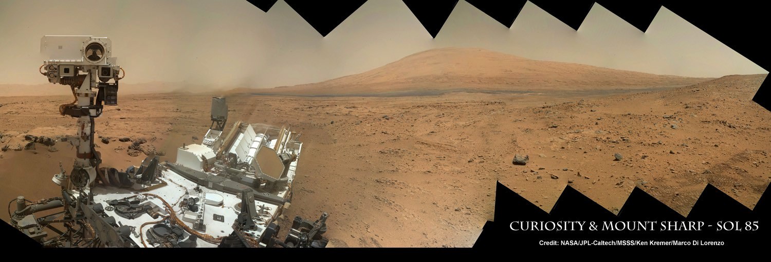
What has followed in the last 25 months since the landing is simply staggering. Mars Curiosity Rover, with the most advanced array of instruments and tools ever delivered to a celestial body, has already delivered an immense trove of images and scientific data that is improving and changing our understanding of Mars.

HIRISE images from the orbiting MRO spacecraft are used to show the old and new routes of NASA's Mars Curiosity rover. The new route provides excellent access to many features in the Murray Formation. And it will eventually pass by the Murray Formation's namesake, Murray Buttes, previously considered to be the entry point to Mt. Sharp. (Credit: NASA/JPL-Caltech/Univ. of Arizona)
HIRISE images from the orbiting MRO spacecraft are used to show the old and new routes of NASA’s Mars Curiosity rover. The new route provides excellent access to many features in the Murray Formation. And it will eventually pass by the Murray Formation’s namesake, Murray Buttes, previously considered to be the entry point to Mt. Sharp. (Credit: NASA/JPL-Caltech/Univ. of Arizona)

Curiosity had been making progress towards an entry point to Mount Sharp called Murray Buttes, however, because of challenges that the terrain posed – sand dunes and treacherous rocks, they have chosen to enter at Pahrump Hills. Furthermore, the new entry to the lower slopes of Mount Sharp are considered scientifically more interesting. The boundary between the mountain and the crater-floor deposits is not an exact one but NASA scientists explained the reason for the announcement at this point:

“Both entry points lay along a boundary where the southern base layer of the mountain meets crater-floor deposits washed down from the crater’s northern rim.” The terrain is now primarily material from the mountain from here on upward.

Image taken by the MastCam of Curiosity Rover on August 23, 2012 which shows the buttes representing the base of Mount Sharp, including Murray Buttes. Today, two years later, Mars Curiosity now stands at entry points in the region of the buttes at 6.6 km (direct line distance). In the middle of the image is the boulder-strewn area in which much of Curiosity's wheel damage occurred. At top are the expansive series of sendiments that is the great interest of Mars researchers. (Credit: NASA/JPL)
Image taken by the MastCam of Curiosity Rover on August 23, 2012 which shows the buttes representing the base of Mount Sharp, including Murray Buttes. Today, two years later, Mars Curiosity now stands at entry points in the region of the buttes at 6.6 km (direct line distance). In the middle of the image is the boulder-strewn area in which much of Curiosity’s wheel damage occurred. At top are the expansive series of sendiments that is the great interest of Mars researchers. (Credit: NASA/JPL)

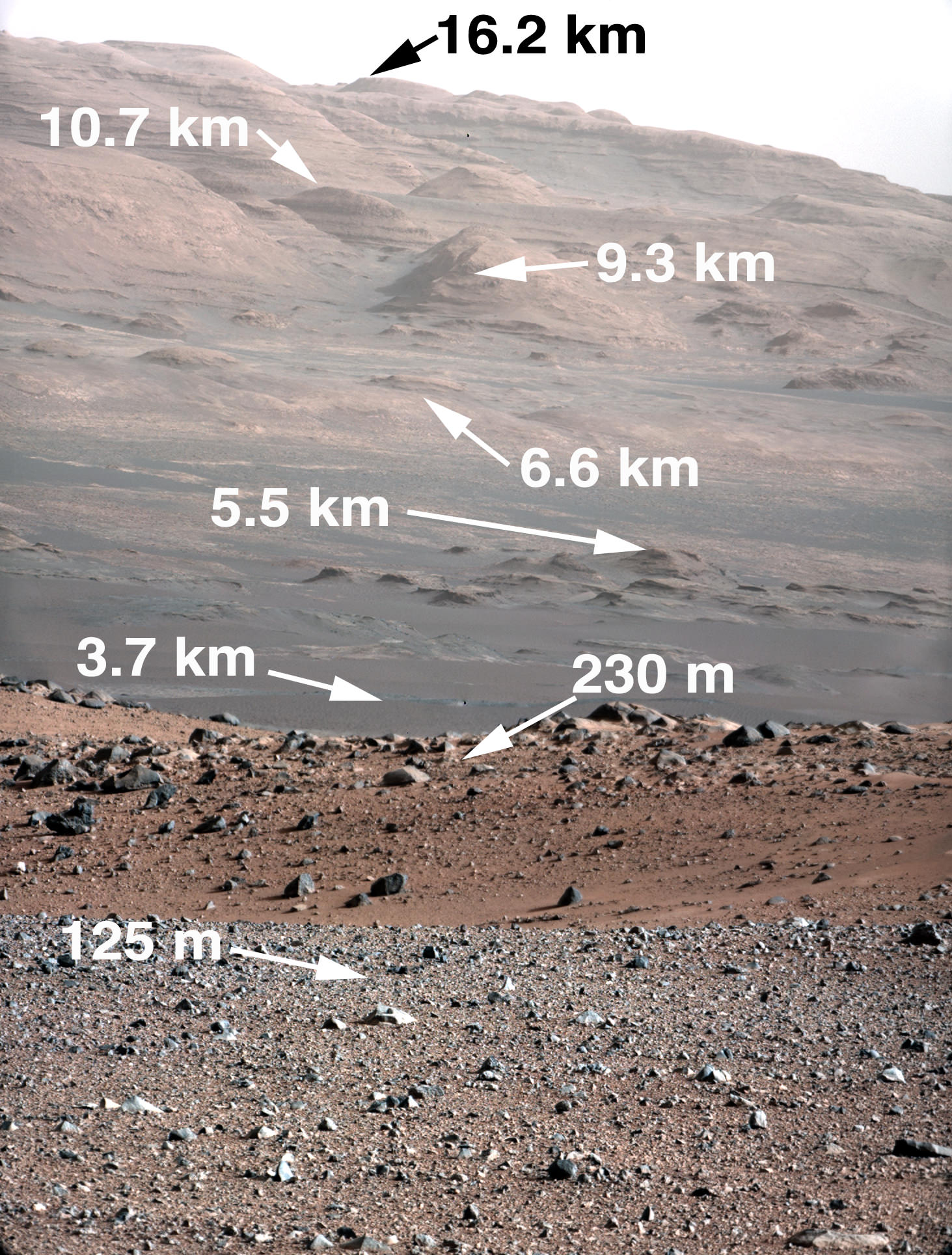
Mount Sharp is anything but the normal central peak of an impact crater. Gale crater at 154 km (96 miles) in diameter is what is called a complex crater. Beyond a certain size, depending on the gravity of the planet, craters will have a central peak. It is similar to the spike of water which is thrust upwards when you drop an object into a pool of water. Like the spike of water, an impact, thrusts regolith upwards and it collapses and coalesces into a central peak. However, with Mount Sharp there is something more. If the peak was nothing but a central impact peak, NASA with Mars Curiosity would not be trekking inside Gale Crater.

As data and analysis has accumulated from not just Mars Curiosity Rover but rather from all the active Mars missions, the models and hypotheses describing the structure and morphology on Mars has become more complex. This model and explanation of how Mount Sharp built up over billions of years uses deposition of ice and dust. Click to enlarge to review the five steps to making a layer cake mountain - Aeolis Mons (Mount Sharp). It is a process which is comparable to how the Martian polar caps formed. Illustration presented by Paul Niles (NASA Johnson Space Center) and Joseph Michalski (Planetary Science Insitute, UK)at the 43rd Lunar and Planetary Science Conference, The Woodlands, Texas)
As data and analysis has accumulated from not just Mars Curiosity Rover but rather from all the active Mars missions, the models and hypotheses describing the structure and morphology on Mars have become more complex. This model and explanation of how Mount Sharp built up over billions of years uses deposition of ice and dust. Click to enlarge and review the five steps to making a layer cake mountain – Mount Sharp. (Credit:  Illustration presented by Paul Niles (NASA Johnson Space Center) and Joseph Michalski (Planetary Science Insitute, UK)at the 43rd Lunar and Planetary Science Conference, The Woodlands, Texas)

Mars scientists believe that Gale crater after its creation was completely filled with sedimentary material from a series of huge floods passing over the surrounding terrain or by dust and ice deposits such as happened at the Martian polar caps. The deposition over 2 billion years left a series sedimentary layers that filled the crater.

Following the deposition of the layers, there was a long period of erosion which has finally led to the condition of the crater today. The erosion by some combination of aeolean (wind) forces and water (additional flooding), scooped out the huge crater, re-exposing most of the original depth. However, covering the original central peak are many sedimentary layers of debris. Gale crater’s original central peak actually remains completely hidden and covered by sedimentation. This is what has attracted scientists with Curiosity to the base of Mount Sharp.

The Mars Trek of NASA's Curiosity Rover from Bradbury Station (landing site) up to Martian Sol 743. The announcement that Curiosity has reached the base of Mt. Sharp is Sol 746. (Credit: NASA/JPL)
The trek of NASA’s Curiosity Rover from Bradbury Station (landing site, Sol 1) up to Martian Sol 743. The announcement that Curiosity had reached the base of Mt. Sharp is Sol 746. On Martian Sol 675, the Rover took its first step beyond its landing ellipse. (Credit: NASA/JPL)

Within the sedimentary layers covering Mount Sharp, there is a sequential record of the events that laid down the layers. Embedded in each of those layers is a record of the environmental conditions on Mars going back over 2 billion years. At the base are the oldest sedimentary layers and as Curiosity climbs the flanks of the mountain, it will step forward in time. The advanced instrumentation residing on and inside Curiosity will be able to analyze each layer for material content and also determine its age. Each layer and its age will reveal information such as how much water was present, whether the water was alkaline or acidic, if there is any organic compounds. The discovery of organic compounds on Mount Sharp could be, well, Earth shaking. There are organic compounds and then there are organic compounds that are linked to life and this search for organics is of very high importance to this mission.

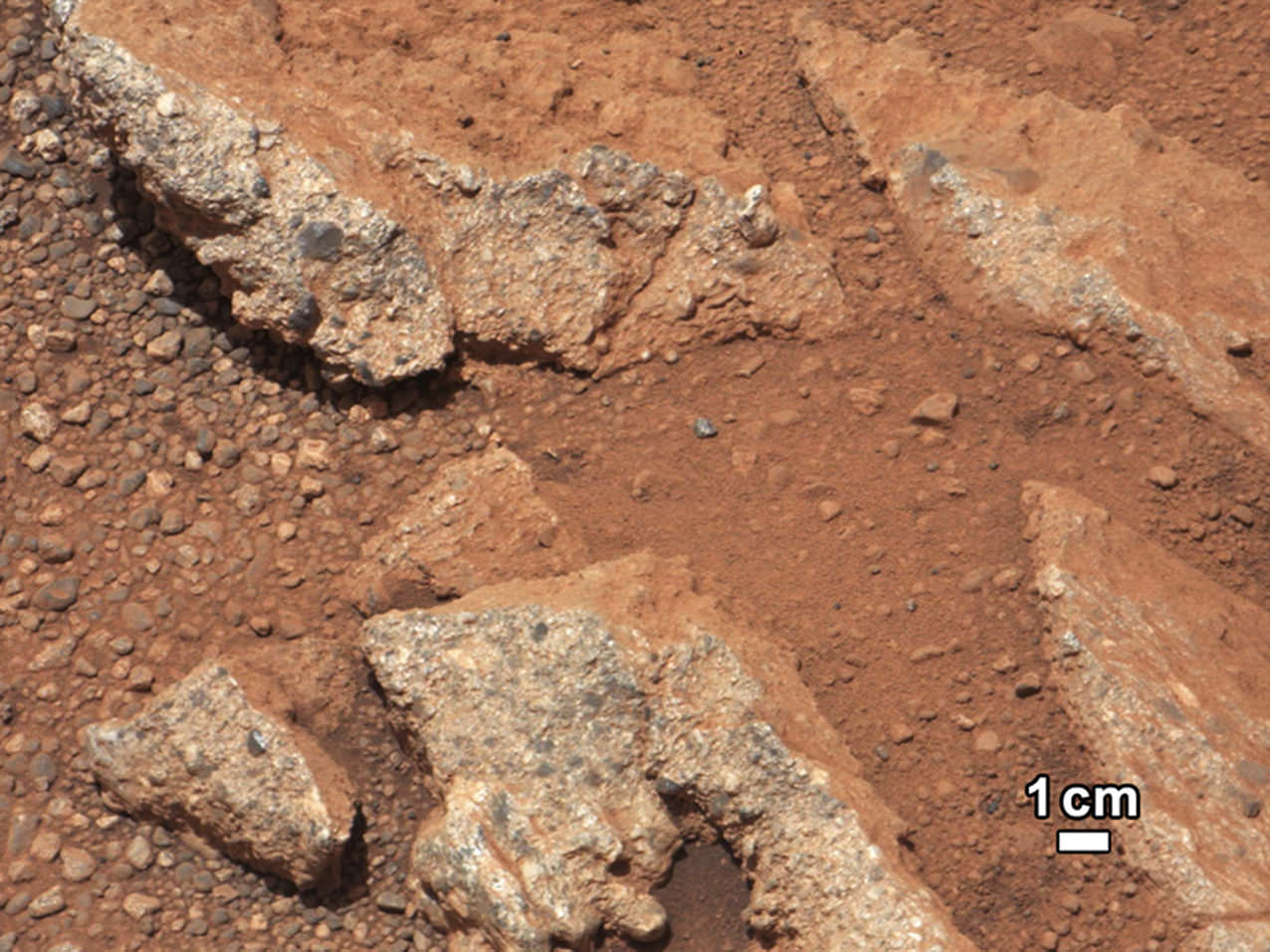
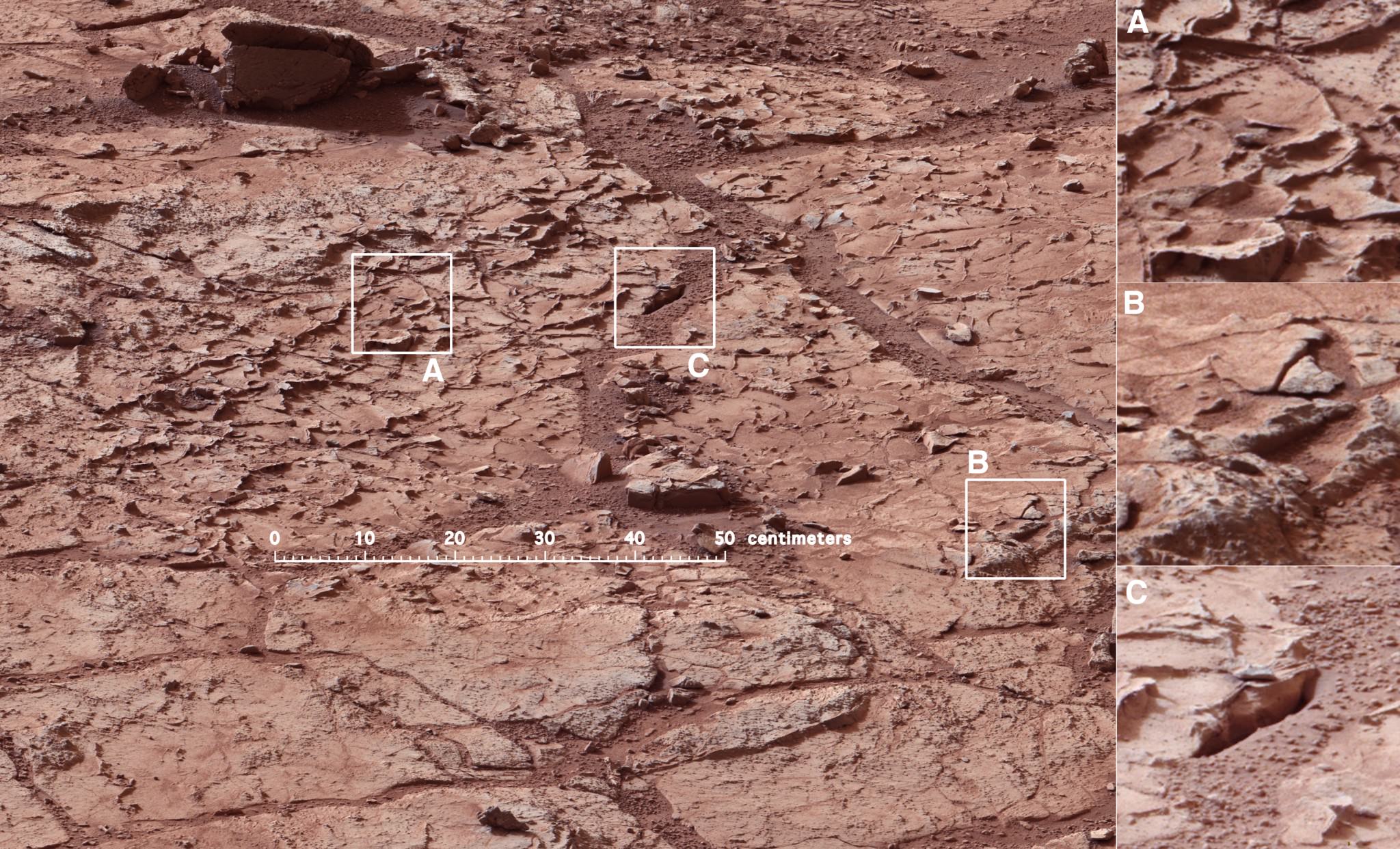
Already, over the two year trek, Curiosity has seen numerous signs of the flow of water and sedimentation. At its first major waypoint, Glenelg, Curiosity stepped into an area called Yellow Knife Bay that showed numerous signs of past water. There were veins of magnesium  salt deposits embedded in the soil, sedimentation and even conglomerate rock such as that found in river beds.

In late 2013, wear and tear accelerated on Curiosity's wheels, the result of crossing boulder-strewn terrain. Clearly signs of punctures, tears and dents are seen in the photo taken by Curiosity performing a self-inspection. While it certainly raised alarm, mission planners remain confident that it can be handled and will not limit the duration of the mission.(Credits: NASA/JPL)
In late 2013, wear and tear accelerated on Curiosity’s wheels, the result of crossing boulder-strewn terrain. Clearly signs of punctures, tears and dents are seen in the photo taken by Curiosity performing a self-inspection. While it certainly raised alarm, mission planners remain confident that it can be handled and will not limit the duration of the mission.(Credits: NASA/JPL)

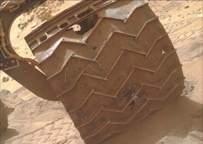
There is another side to the terrain that Curiosity is traversing. The crater floor, essentially a flood plain has been particularly hard on the mobility system of Curiosity. This is to say that the sharp rocks it continues to encounter under foot are taking a toll on the wheels. Curiosity is now being operated in reverse in order to reduced the impact forces on its wheels.

Furthermore, while scientists are helping to choose the path of the rover, the Curiosity drivers who must assess the field ahead must find paths with fewer sharp rocks in order to slow the damage being done. The Mars Curiosity team is concerned but remain confident that the mobility system will be capable of surviving the ten year life span of the rover’s power supply. So, the momentous occasion is hardly a time to pause and reflect, the trek moves upward, northward to see what the layers on Mount Sharp will reveal.

There are competing hypotheses on how Mount Sharp evolved. Here are two worthy web pages with additional reading.

Crater mound a prize and puzzle for Mars rover“, Eric Hand, August 3, 2012

Big pile in Gale Crater“, R. Burnham, March 30, 2012

For further reading –

NASA’s Mars Curiosity Rover Arrives at Martian Mountain“, September 11, 2014

Recommended gateway to the Mars Curiosity web pages – a Curiosity Slide Show

Recent Universe Today articles on Curiosity: Sept 9,  Sept. 4,  Aug 23, Aug 20, Aug 16

One Reply to “An Incredible Journey, Mars Curiosity Rover Reaches the Base of Mount Sharp”

  1. Good job with the graphics! This is the clearest explanation I’ve read (except for a few typos?) and seen describing how Aeolis Mons was created. Nice!

    Now if only the comments section allowed posts again….

Comments are closed.