Curiosity rover panorama of Mount Sharp captured on June 6, 2014 (Sol 651) during traverse inside Gale Crater. Note rover wheel tracks at left. She will eventually ascend the mountain at the ‘Murray Buttes’ at right later this year. Assembled from Mastcam color camera raw images and stitched by Marco Di Lorenzo and Ken Kremer. Credit: NASA/JPL/MSSS/Marco Di Lorenzo/Ken Kremer-kenkremer.com
Story updated[/caption]
Within the past Martian day on Friday, June 6, NASA’s rover Curiosity captured a stunning new panorama of towering Mount Sharp and the treacherous sand dunes below which she must safely traverse before reaching the mountains foothills – while ‘On The Go’ to her primary destination.
See our brand new Mount Sharp photo mosaic above – taken coincidentally by humanity’s emissary on Mars on the 70th anniversary of D-Day on Earth.
Basically she’s eating desiccated dirt while running a Martian marathon.
Having said ‘Goodbye Kimberley’ after drilling her third bore hole deep into a cold red slab of enticing bumpy textures of Martian sandstone in the name of science, our intrepid mega rover Curiosity is trundling along with all deliberate speed towards the inviting slopes of sedimentary rocks at the base of mysterious Mount Sharp which hold clues to the habitability of the Red Planet.
The sedimentary layers of Mount Sharp, which reaches 3.4 miles (5.5 km) into the Martian sky, is the six wheeled robots ultimate destination inside Gale Crater because it holds caches of water altered minerals.
Such minerals could possibly mark locations that sustained potential Martian microbial life forms, past or present, if they ever existed.
Mars was far wetter and warmer – and more conducive to the origin of life – billions of years ago.
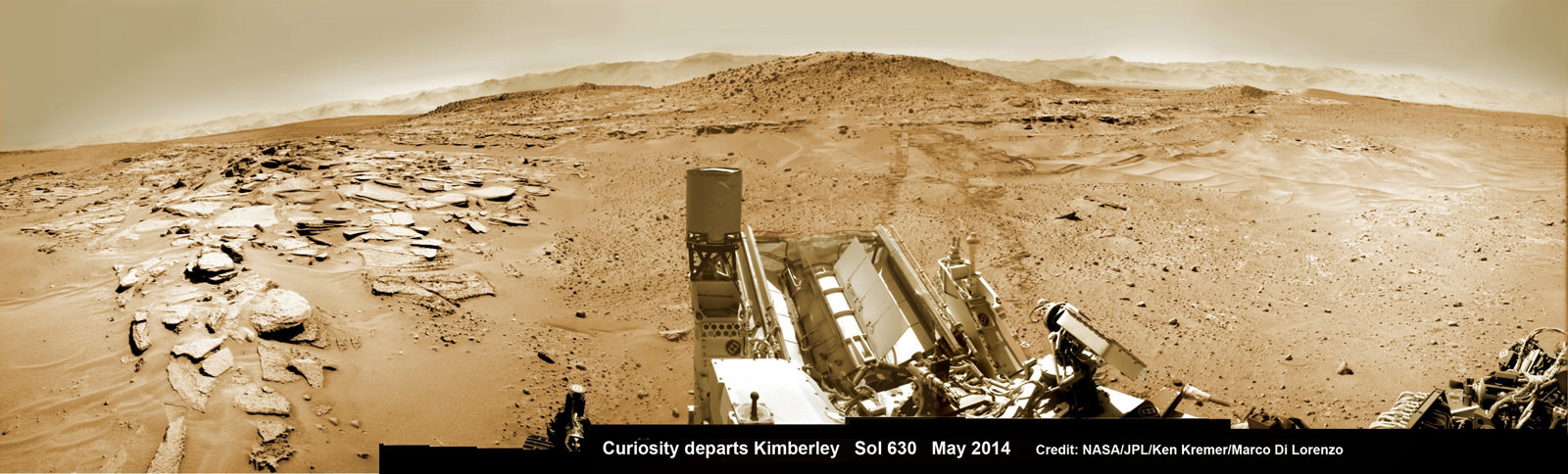
The 1 ton robot is driving on a path towards the Murray Buttes which lies across the dunes on the right side of Mount Sharp as seen in our photo mosaic above, with wheel tracks on the left side.
She will eventually ascend the mountain at the ‘Murray Buttes’ after crossing the sand dunes.
Curiosity still has roughly another 4 kilometers of driving to go to reach the foothills of Mount Sharp sometime later this year.
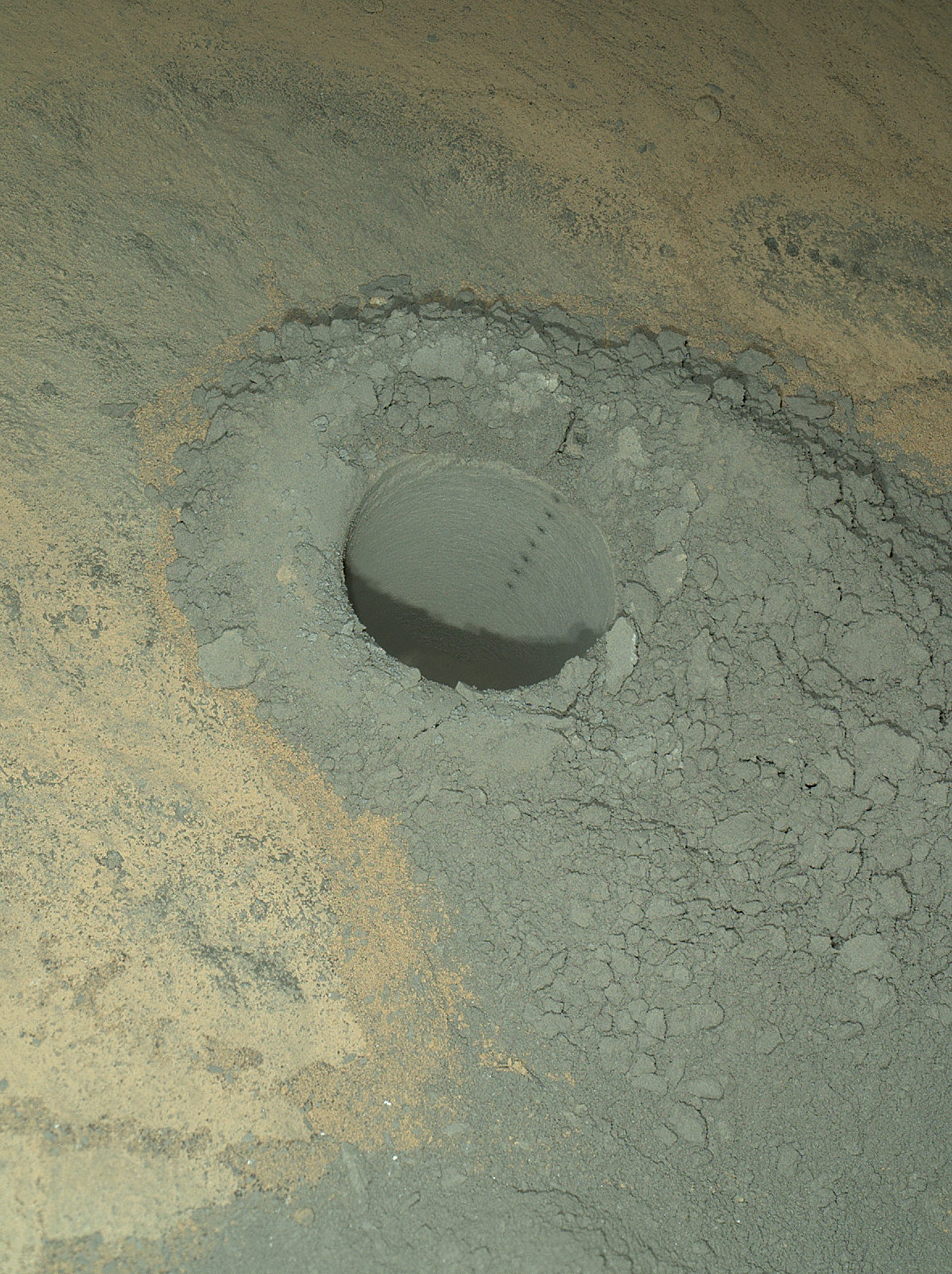
Approximately four weeks ago, Curiosity successfully completed her 3rd drilling campaign since landing at the science waypoint region called “The Kimberley” on May 5, Sol 621, into the ‘Windjana’ rock target at the base of a 16 foot tall ( 5 Meter) hill called Mount Remarkable.

The fresh hole drilled into “Windjana” was 0.63 inch (1.6 centimeters) in diameter and about 2.6 inches (6.5 centimeters) deep and resulted in a mound of dark grey colored drill tailings piled around. It looked different from the initial holes drilled at Yellowknife Bay in the spring of 2013.
Windjana lies some 2.5 miles (4 kilometers) southwest of Yellowknife Bay.
Curiosity then successfully delivered pulverized and sieved samples to the pair of onboard miniaturized chemistry labs; the Chemistry and Mineralogy instrument (CheMin) and the Sample Analysis at Mars instrument (SAM) – for chemical and compositional analysis.
Before departing, Curiosity blasted the hole multiple times with her million watt laser on the Mast mounted Chemistry and Camera (ChemCam) instrument , leaving no doubt of her capabilities or intentions.
And she completed an up close examination of the texture and composition of ‘Windjana’ with the MAHLI camera and spectrometers at the end of her 7-foot-long (2 meter) arm to glean every last drop of science before moving on.
“Windjana” is named after a gorge in Western Australia.
While ‘On the Go’ to Mount Sharp, the rover is keeping busy with science activities by investigating the newly cored Martian material.
“Inside Curiosity we continue to analyse the Kimberley samples with CheMin and SAM,” wrote mission team member John Bridges in an update.
To date, Curiosity’s odometer totals 3.8 miles (6.1 kilometers) since landing inside Gale Crater on Mars in August 2012. She has taken over 154,000 images.
Stay tuned here for Ken’s continuing Curiosity, Opportunity, Orion, SpaceX, Boeing, Orbital Sciences, commercial space, MAVEN, MOM, Mars and more planetary and human spaceflight news.

Featured on APOD – Astronomy Picture of the Day on May 7, 2014