If you could spend a few months -- or even a few
days
-- living aboard the ISS, what would you take pictures of? Earth, most likely, with your favorite landforms and your family's and friends' hometowns ranking high on the list. After a while, I'm sure plenty of other Earthly features would become photo targets -- weather, aurorae, world cities at night, etc. -- but ultimately, over the course of your stay in orbit, you would be able to see a trend in the pictures you take, and where you took them.
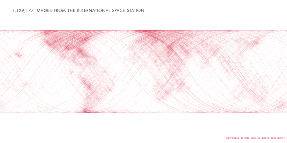
And over the span of 35 missions across more than 12 years, the graph above shows the trend of
all
the astronauts' pictures. Look familiar?
[caption id="attachment_101166" align="alignright" width="250"]
Nighttime photo of the Nile delta region taken from the ISS (NASA)[/caption]
Created by open-source NASA data aficionado Nate Bergey, the image above is a map made up of over a million points (1,129,177, to be exact) each representing the global coordinates of an JSC-archived photograph taken from the ISS.
Clearly the continents are astronauts' favored photo subjects, with the populous urban areas of North America, Europe, Egypt and the Middle East, as well as the western and southern coasts of South America standing out.
"This makes sense, photos of clouds over an otherwise blank ocean get old after a while," Nate Bergey wrote on his blog,
open.nasa.gov
. "I'm sure every astronaut has taken at least one photograph of the town they grew up in."
Of course, the map doesn't create an image of the
entire
globe. This is because the points denote actual over-ground coordinates of the Station (not necessarily what the photos themselves are of) and "the ISS stays between about 50° and -50° latitude as it orbits the Earth," as noted by Bergey.
A map of the world with the points overlaid onto it, color-coded by mission, shows the difference:
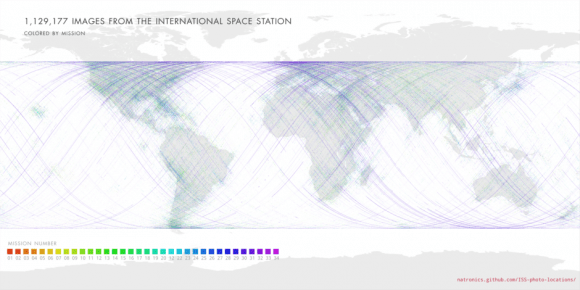
Bergey also notes the proliferation of purple-colored dots... these indicate the hundreds of images taken by
NASA astronaut Don Pettit
during Expedition 30/31, when he created incredible time-lapse videos of the Earth from the ISS.
[caption id="attachment_101164" align="aligncenter" width="580"]
One of many long-exposure images taken by Don Pettit aboard the ISS (NASA/JSC). See more
here
.[/caption]
With such a unique and lofty perspective of our world, it's no wonder that astronauts spend so much time snapping photos -- I can't say I'd be able to tear myself away from the window myself! Read more about Nate Bergey's project and how he created his map
on his open.NASA blog here.